|

|
|
Water Resources Data - Texas Water Year 2001 Volume 2. Trinity River Basin
Water Data Report TX-01-2
By S.C. Gandara
Abstract: Water-resources data for the 2001 water year for Texas are presented in six volumes, and consist of records of
stage, discharge, and water quality of streams and canals; stage, contents, and water-quality of lakes and reservoirs; and water levels and water quality of ground-water
wells. Volume 2 contains records for water discharge at 50 gaging stations; stage only at 2 gaging stations; stage and contents at 21 lakes and reservoirs; water quality at
32 gaging stations; and data for 2 partial-record stations comprised of 1 flood-hydrograph and 1 crest-stage stations. Also included are lists of discontinued surface-water
discharge or stage-only stations and discontinued surface-water-quality stations. Additional water data were collected at various sites, not part of the systematic
data-collection program, and are published as miscellaneous measurements. These data represent that part of the National Water Data System operated by the U.S. Geological
Survey and cooperating Federal, State, and local agencies in Texas. Records for a few pertinent stations in the bordering States also are included.
|
|
Volume 2. Trinity River Basin: Water Data Report TX-01-2
Vol. 2 Compressed (.zip) 2,541,000 Bytes (6 minutes at 56K)
Vol. 2 Uncompressed (.pdf) 4,588,000 Bytes (12 minutes at 56K) |
|
| Other Volumes In This Set: |
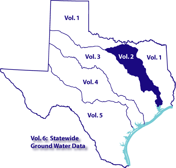
Volume 1. Arkansas River Basin, Red River Basin, Sabine River Basin, Neches River Basin, and
Intervening Coastal Basins: Water Data Report TX-01-1
Volume 3. San Jacinto River Basin, Brazos River Basin, San Bernard River Basin, and
Intervening Coastal Basins: Water Data Report TX-01-3
Volume 4. Colorado River Basin, Lavaca River Basin, and Intervening Coastal Basins: Water
Data Report TX-01-4
Volume 5. Guadalupe River Basin, Nueces River Basin, Rio Grande Basin, and Intervening
Coastal Basins: Water Data Report TX-01-5
Volume 6. Ground Water: Water Data Report TX-01-6
|
| Volumes 1-6 Complete Set: Compressed (.zip) 24,495,000 Bytes (58 minutes at
56K) |
Choosing The Proper Volume: The 2001 water resources data were published in
six volumes. Volumes 1 through 5 focus on streamflow and water-quality data within
a specific basin or group of basins. Volume 6 contains all published ground-water
data. To assist you in downloading the proper volume, we have provided the
following resources:
Volumes 1 - 5 listing by station identification number
Volumes 1 - 5 listing by station name
|
|
|
CONTENTS
Preface
List of gaging stations, in downstream order, for which records are published
List of discontinued surface-water discharge or stage-only stations
List of discontinued surface-water-quality stations
Introduction
Cooperation
Hydrologic conditions
Streamflow
Water quality
Special networks and programs
Explanation of the records
Station identification numbers
Downstream order numbering
Records of stage and water discharge
Data collection and computation
Data presentation
Station manuscript
Data table of daily mean values
Statistics of monthly mean data
Summary statistics
Identifying estimated daily discharge
Accuracy of the records
Other records available
Records of surface-water quality
Classification of records
Arrangement of records
On-site measurements and sample collection
Water temperature
Sediment
Laboratory measurements
Data presentation
Remarks codes
Water Quality-Control Data
Blank samples
Reference samples
Replicate samples
Spike samples
Access to USGS water data
Definition of terms
Publications of techniques of water-resources investigations
Gaging-station records
Discharge at crest-stage partial-record stations
Index
|