 Introduction
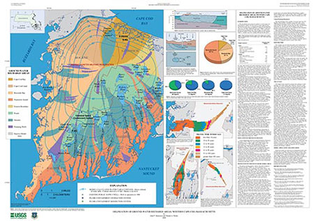
The unconfined sand-and-gravel aquifer in western Cape Cod,
Massachusetts, which is the sole source of water supply for the
communities in the area, is recharged primarily from precipitation.
The rate of recharge from precipitation is estimated to be about 26
inches per year (in/yr), or about 60
percent of the precipitation rate. This recharge rate yields a flow
through the aquifer of about 180 million gallons per day (Mgal/d).
Groundwater flows radially outward from the top of
the water-table mound in the north-central part of the flow system
toward the coast, as indicated by the water-table contours on the
large map on this sheet. Recharge that reaches the water
table near the top of the mound travels deeper through the aquifer
than recharge that reaches the water table closer to the coast.
All recharge to the aquifer ultimately discharges to pumping wells,
streams, or coastal areas; however, some of this recharge may flow
first through kettle ponds before eventually reaching these
discharge points.
Continued land development and population growth on
western Cape Cod, and activities related to the operation of the
Massachusetts Military Reservation (MMR), have created concerns
regarding the supply of potable water in western Cape Cod and the
quality and quantity of water discharging to ponds, streams, and
coastal areas. Recent investigations estimated the future demand
for drinking water in western Cape Cod, as well as the areas that contribute
water to existing and proposed public-supply wells. Determining the source of freshwater that discharges
to ponds, streams, and coastal areas is of critical importance in the
protection of these natural resources for the communities of western
Cape Cod.
The purpose of this report is to illustrate concepts of
ground-water recharge areas under average pumping and recharge
conditions. This report presents results of an investigation
conducted by the U.S. Geological Survey (USGS), in cooperation
with the Air Force Center for Environmental Excellence (AFCEE),
to delineate the areas that contribute recharge to public-supply
wells, ponds, streams, and coastal areas on western Cape Cod for
average annual pumping and recharge rates for the period of
1994–1996.
The time period of 1994–1996 was selected for this analysis
because it represents the average stress conditions prior to
large-scale pumping, treatment, and reinjection of water from the
MMR Installation Restoration Program's ground-water remediation
systems. The pumping and reinjection of large amounts of water
from these remediation systems would complicate greatly the
delineation of ground-water recharge areas and therefore is beyond
the scope of this analysis. The Chemical Spill-4 plume-containment
system, however, is included in the simulation since it has
been operating since 1993 and has been pumping, treating, and
reinjecting only about 0.2 Mgal/d of water.
Since 1996, however, AFCEE has constructed remediation
systems for seven additional contaminant plumes that are not included in this analysis.
Currently (1999), these systems are pumping, treating, and
reinjecting about 9.7 Mgal/d. By 2002, when all of these systems,
including those being designed, are expected to be operating, it is
estimated that they will be pumping, treating, and reinjecting as
much as 15.6 Mgal/d of water in the western Cape Cod aquifer.
For additional information on the hydrology and geology of
western Cape Cod, the reader is referred to the following reports:
LeBlanc and others (1986), Barlow and Hess (1993), Masterson and
others (1997a), Masterson and others (1997b), Masterson and others
(1998), Ogden Environmental and Energy Services, Inc. (1998) and
Jacobs Engineering Group, Inc. (1999).

