Water-Resources Investigations Report 02-4082
![]() This report is available online in pdf format (6 MB): USGS WRIR02-4082 (
This report is available online in pdf format (6 MB): USGS WRIR02-4082 (![]() )
)
Elizabeth A. Frick, M. Brian Gregory, Daniel L. Calhoun, and Evelyn H. Hopkins
U.S. Geological Survey Water-Resources Investigations Report 02-4082, 72 pages (Published 2002)
 Cumberland Island is the southernmost and largest barrier island along the coast of Georgia. The island contains about 2,500 acres of freshwater wetlands that are located in a variety of physical settings, have a wide range of hydroperiods, and are influenced to varying degrees by surface and ground water, rainwater, and seawater. In 19992000, the U.S. Geological Survey, in cooperation with the National Park Service, conducted a water-quality study of Cumberland Island National Seashore to document and interpret the quality of a representative subset of surface- and ground-water resources for management of the seashores natural resources. As part of this study, historical ground-water, surface-water, and ecological studies conducted on Cumberland Island also were summarized.
Surface-water samples from six wetland areas located in the upland area of Cumberland Island were collected quarterly from April 1999 to March 2000 and analyzed for major ions, nutrients, trace elements, and field water-quality constituents including specific conductance, pH, temperature, dissolved oxygen, alkalinity, tannin and lignin, and turbidity. In addition, water temperature and specific conductance were recorded continuously from two wetland areas located near the mean high-tide mark on the Atlantic Ocean beaches from April 1999 to July 2000. Fish and invertebrate communities from six wetlands were sampled during April and December 1999. The microbial quality of the near-shore Atlantic Ocean was assessed in seawater samples collected for 5 consecutive days in April 1999 at five beaches near campgrounds where most recreational water contact occurs.
Ground-water samples were collected from the Upper Floridan aquifer in April 1999 and from the surficial aquifer in April 2000 at 11 permanent wells and 4 temporary wells (drive points), and were analyzed for major ions, nutrients, trace elements, and field water-quality constituents (conductivity, pH, temperature, dissolved oxygen, and alkalinity). Fecal-coliform bacteria concentrations were measured, but not detected, in samples collected from two domestic water-supply wells. During the 12-month period from April 1999 to March 2000 when water-quality and aquatic-community samples were collected, rainfall was 12.93 inches below the 30-year average rainfall.
Constituent concentrations were highly variable among the different wetlands during the study period. Rainfall and tidal surges associated with tropical storms and hurricanes substantially influenced water quantity and quality, particularly in wetland areas directly influenced by tidal surges. Although surface waters on Cumberland Island are not used as sources of drinking water, exceedances of U.S. Environmental Protection Agency primary and secondary standards for drinking water were noted for comparative purposes. A nitrate concentration of 12 milligrams per liter in one sample from Whitney outflow was the only exceedance of a maximum contaminant level. Secondary standards were exceeded in 26 surface-water samples for the following constituents: pH (10 exceedances), chloride (8), sulfate (5), total dissolved solids (4), iron (2), fluoride (1), and manganese (1). The total-dissolved-solids concentrations and the relative abundance of major ions in surface-water samples collected from wetlands on Cumberland Island provide some insight into potential sources of water and influences on water quality. Major-ion chemistries of water samples from Whitney Lake, Willow Pond, and South End Pond 3 were sodium-chloride dominated, indicating direct influence from rainwater, salt aerosol, or inundation of marine waters. The remaining wetlands sampled had low total-dissolved-solids concentrations and mixed major-ion chemistriesNorth Cut Pond 2A was magnesiumsodiumchloridesulfate dominated and Lake Retta and the two beach outflows were sodiumcalciumbicarbonatechloride dominated. The higher percent calcium and bicarbonate in some wetlands suggests a greater influence from ground-water discharge.
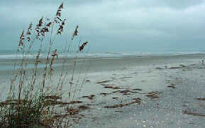
Aquatic insects whose life cycles and behavioral adaptations allow them to inhabit wetlands characterized by a range of hydroperiods, water-quality, and habitat conditions dominated aquatic-invertebrate communities in upland wetlands of Cumberland Island. In foredune areas adjacent to the Atlantic Ocean, estuarine wetlands contained marine invertebrates such as shrimp and crabs, along with aquatic insects typically associated with freshwater wetlands. The richest invertebrate communities were present in floating and emergent aquatic vegetation of Whitney Lake. Fish communities of Cumberland Island wetlands were typically dominated by species that tolerate highly variable water-quality conditions and bear their young live, attributes that allow these species to quickly populate water bodies with short or variable hydroperiods. The most diverse wetland areas in terms of fish communities were the beach outflows. Species inhabiting beach outflows consisted of fishes able to tolerate fresh- to brackish-water conditions and species typically associated with marine waters.
 Cumberland Island is within the cone of depression associated with large withdrawals for industrial use that have occurred since 1939 in Fernandina Beach, Fla. and in St Marys, Ga. In 1999, the potentiometric surface of the Upper Floridan aquifer ranged from a maximum of about 40 feet above sea level at the northern most well measured to a minimum of about 18 feet above sea level near the southern end of Cumberland Island. Limited ground-water-level measurements in wells on Cumberland Island indicate seasonal and annual variability in water levels; however, water-level data are not sufficient to make conclusions about trends in water levels on Cumberland Island during the last decade.
U.S. Environmental Protection Agency maximum contaminant levels and secondary standards for drinking water were not exceeded in five domestic water-supply wells open to the Upper Floridan aquifer that were sampled in 1999. Chloride concentrations ranging from about 31 to 37 mg/L and limited evidence related to the depth and location of the freshwater/saltwater interface indicate that saltwater intrusion is currently not a problem in the Upper Floridan aquifer on Cumberland Island. Saltwater intrusion into the shallow surficial aquifer at the southern end of Cumberland Island is the primary reason for common exceedances of the secondary standards for chloride, sulfate, total dissolved solids, and manganese.
Abstract
Introduction
Purpose and scope
Surface water
Ground water
Previous investigations
Acknowledgments
Methods of investigation
Surface water
Surface-water quality
Aquatic communities
Ground-water quality
Surface water
Surface-water quality
Aquatic communitiesDescriptions of water bodies
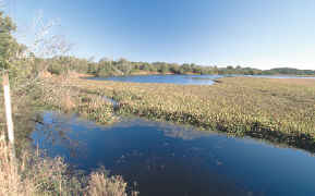
North Cut Ponds
Whitney Lake
Willow Pond
Lake Retta complex
Beach outflows
South End Ponds
Ground water
Ground-water levels
Ground-water quality
Summary
References cited
Glossary
Appendix A.Surface-water-quality data, Cumberland Island, April 1999 through March 2000
Appendix B.Enterococci concentrations of the near-shore Atlantic Ocean, Cumberland Island, April 2630, 1999
Appendix C.Ground-water-quality data, Cumberland Island, April 1999 and March 2000
Appendix D.Ground-water-quality data for wells screened in the surficial aquifer, southern end of Cumberland Island, 1989
Appendix E.Ground-water-quality data for a well open to the Upper Floridan aquifer, Cumberland Island, 19942000
![]() This report is available online in pdf format (6 MB): USGS WRIR02-4082 (
This report is available online in pdf format (6 MB): USGS WRIR02-4082 (![]() )
)
To view the PDF document, you need the Adobe Acrobat® Reader installed on your computer. (a free copy of the Acrobat® Reader may be downloaded from Adobe Systems Incorporated.)
Recent USGS publications on Georgia or Georgia Water-Resources Information
For more information, please contact webmaster-ga@usgs.gov .

![]() U.S. Department of the Interior |
U.S. Geological Survey
U.S. Department of the Interior |
U.S. Geological Survey
URL: https://pubsdata.usgs.gov/pubs/wri/wri02-4082/index.html
Page Contact Information: Publications Team
Page Last Modified: Wednesday, 07-Dec-2016 13:31:39 EST
