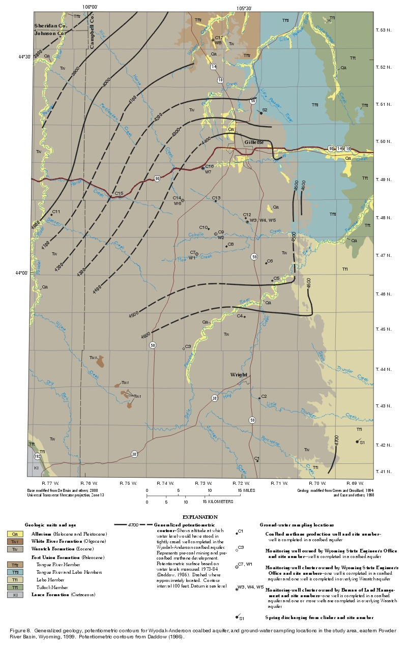
![]()
Table 1. Identification numbers, well-completion information, water levels, geologic units, and assigned hydrogeologic units for wells sampled in the study area
[P, perforated well casing; S, commercial well screen; O, open hole; L, well liner; --, water level not recovered from well installation; LS, water level at land surface]
| Site number (fig. 8) | U.S. Geological Survey site-identification number | Local well number | Land-surface elevation (feet above sea level) | Depth of well (feet below land surface) | Elevation of bottom of well (feet above sea level) | Date of water-level measurement |
|---|---|---|---|---|---|---|
| W1 | 440253105385702 | 47-073-16cbc02 | 4,850 | 910 | 3,940 | 6-16-99 |
| W2 | 440542105351802 | 48-073-36bcc02 | 4,740 | 700 | 4,040 | 6-17-99 |
| W3 | 440724105291301 | 48-072-22adc01 | 4,574 | 410 | 4,164 | 6-24-99 |
| W4 | 440724105291302 | 48-072-22adc02 | 4,574 | 185 | 4,385 | 6-25-99 |
| W5 | 440724105291303 | 48-072-22adc03 | 4,574 | 80 | 4,490 | 6-25-99 |
| W6 | 441019105414502 | 49-074-36ddc02 | 4,915 | 1,100 | 3,815 | -- |
| W7 | 441451105375502 | 1,249-073-03cc02 | 4,775 | 750 | 4,025 | 6-17-99 |
| W8 | 443241105360801 | 53-073-26dba01 | 4,045 | 3200 | 3,844 | 6-29-99 |
| C1 | 433408105270101 | 242-072-36dbc01 | 4,998 | 765 | 4,233 | 45-17-98 |
| C2 | 434252105264301 | 243-072-12dac01 | 4,861 | 5650 | 4,211 | 45-08-99 |
| C3 | 434941105412001 | 45-074-36dad01 | 4,883 | 61,220 | 3,663 | 6-22-99 |
| C4 | 435411105294001 | 45-072-03dbd01 | 4,876 | 7703 | 4,173 | 412-20-96 |
| C5 | 435915105242201 | 46-071-05dda01 | 4,625 | 340 | 4,285 | 42-18-97 |
| C6 | 440139105253301 | 47-071-30aaa01 | 4,709 | 399 | 4,310 | 46-18-96 |
| C7 | 440253105385701 | 47-073-16cbc01 | 4,850 | 1,219 | 3,631 | 6-15-99 |
| C8 | 440358105331401 | 247-072-07acc01 | 4,776 | 853 | 3,603 | 44-22-98 |
| C9 | 440542105351801 | 48-073-36bcc01 | 4,740 | 905 | 3,835 | 6-16-99 |
| C10 | 440623105364101 | 48-073-27dac01 | 4,836 | 81,057 | 3,779 | 45-21-99 |
| C11 | 440808106070601 | 248-077-16acc01 | 4,093 | 91,224 | 2,869 | 46-18-99 |
| C12 | 440756105293301 | 248-072-15dcc01 | 4,613 | 565 | 4,048.4 | 45-24-93 |
| C13 | 441017105352201 | 248-073-02aac01 | 4,718 | 842 | 3,876.3 | 42-04-98 |
| C14 | 441019105414501 | 49-074-36ddc01 | 4,915 | 101,234 | 3,681 | 6-23-99 |
| C15 | 441047105535401 | 49-075-32adb01 | 4,439 | 111,795 | 2,598 | 6-24-99 |
| C16 | 441451105375501 | 249-073-03ccc01 | 4,775 | 905 | 3,870 | 6-17-99 |
| C17 | 443241105360802 | 53-073-26dba02 | 4,044 | 297 | 3,747 | 410-9-98 |
| Site number (fig. 8) | Water level (feet below land surface) | Water-level elevation (feet above sea level) | Open interval (feet below land surface) | Type of open interval | Date construction completed | Geologic unit | Hydrogeologic unit |
|---|---|---|---|---|---|---|---|
| W1 | 365.9 | 4,484.1 | 850-910 | P | 10-06-98 | Wasatch Formation | Wasatch aquifer |
| W2 | 260.2 | 4,479.8 | 670-700 | P | 10-24-98 | Wasatch Formation | Wasatch aquifer |
| W3 | 94.6 | 4,479.4 | 340-410 | P | 02-07-93 | Wasatch Formation | Wasatch aquifer |
| W4 | 36.0 | 4,534.0 | 140-180 | S | 04-22-98 | Wasatch Formation | Wasatch aquifer |
| W5 | 17.5 | 4,552.5 | 15-80 | S | 04-22-98 | Wasatch Formation | Wasatch aquifer |
| W6 | -- | -- | 1,050-1,100 | P | 06-18-99 | Wasatch Formation | Wasatch aquifer |
| W7 | 291.3 | 4,483.7 | 690-750 | P | 10-14-98 | Wasatch Formation | Wasatch aquifer |
| W8 | 21 | 4,024.0 | 3140-200 | S | 05-21-98 | Tongue River Member of the Fort Union Formation above Wyodak-Anderson coal zone | Wasatch aquifer |
| C1 | 4406 | 44,592.0 | 667-765 | O | 05-17-98 | Wyodak-Anderson coal zone | Coalbed aquifers |
| C2 | 4272 | 44,589.0 | 5531-650 | O | 05-08-99 | Wyodak coal bed of the Wyodak-Anderson coal zone | Coalbed aquifers |
| C3 | 241.7 | 4,641.3 | 61,050-1,070 | P | 12-11-98 | Wyodak-Anderson coal zone | Coalbed aquifers |
| C4 | 4319.5 | 44,556.5 | 7661-703 | O | 12-20-96 | Upper Wyodak coal bed of the Wyodak-Anderson coal zone | Coalbed aquifers |
| C5 | 4155 | 44,470.0 | 275-340 | O | 02-18-97 | Wyodak-Anderson coal zone | Coalbed aquifers |
| C6 | 4338 | 44,371.0 | 340-399 | O | 06-18-96 | Wyodak-Anderson coal zone | Coalbed aquifers |
| C7 | 410.9 | 4,439.1 | 1,187-1,219 | P | 10-26-98 | Wyodak-Anderson coal zone | Coalbed aquifers |
| C8 | 4278 | 44,498.0 | 760-853 | O | 05-28-99 | Wyodak coal bed of the Wyodak-Anderson coal zone | Coalbed aquifers |
| C9 | 307.6 | 4,432.4 | 860-905 | P | 10-22-98 | Wyodak-Anderson coal zone | Coalbed aquifers |
| C10 | 4360 | 44,476.0 | 8980-1,057 | O | 05-21-99 | Wyodak coal bed of the Wyodak-Anderson coal zone | Coalbed aquifers |
| C11 | 4LS | 44,093 | 91,003-1,224 | O | 06-11-99 | Big George coal bed | Coalbed aquifers |
| C12 | 4203 | 44,410.4 | 482-565 | O | 05-24-93 | Wyodak-Anderson coal zone | Coalbed aquifers |
| C13 | 4703 | 44,015.3 | 768.5-842.0 | O | 02-04-98 | Wyodak coal bed of the Wyodak-Anderson coal zone | Coalbed aquifers |
| C14 | 481.4 | 4,433.6 | 101,156-1,234 | L | 11-17-98 | Wyodak-Anderson coal zone | Coalbed aquifers |
| C15 | 133.16 | 4,305.8 | 111,728-1,795 | P | 02-10-90 | Coal bed or zone below the Wyodak-Anderson coal zone | Coalbed aquifers |
| C16 | 328.9 | 4,446.1 | 845-905 | L | 10-11-98 | Upper Wyodak coal bed of the Wyodak-Anderson coal zone | Coalbed aquifers |
| C17 | 432.8 | 44,011.2 | 221-297 | O | 07-06-96 | Canyon coal bed of the Wyodak-Anderson coal zone | Coalbed aquifer |
1Plots in section 4 when using Global Positioning System (GPS) location; well is assigned to section 3 on well permit, so this location was used.
2Well located in center of quarter-quarter section.
3Well was drilled to a depth of 201 feet below land surface but was completed to a depth of 200 feet below land surface.
4Water level from Wyoming State Engineer's Office well permit.
5Well was drilled to a depth of 675 feet below land surface but was completed to a depth of 650 feet below land surface.
6Well was cased to a depth of 1,220 feet below land surface but was perforated 1,050 to 1,070 feet below land surface.
7Well was drilled to a depth of 722 feet below land surface but was completed to a depth of 703 feet below land surface.
8Well was drilled to a total depth of 1,066 feet below land surface, and well casing was installed to a depth of 980 feet below land surface; well is open from 980 to 1,057 feet below land surface.
9Well is open to sandstone and shale from 1,003 to about 1,070 feet below land surface and coal from 1,070 to 1,224 feet below land surface.
10Well was drilled to a total depth of 1,263 feet below land surface but was completed to a depth of 1,234 feet below land surface.
11Well was drilled to a total depth of 1,868 feet below land surface, plugged back to 1,841 feet below land surface, cased to 1,841 feet below land surface, and perforated from 1,728 to 1,795 feet below land surface.