|
|
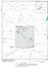
IntroductionMiller Creek is a tributary of Soda Butte Creek in south-central Montana (fig. 1) near the northeast corner of Yellowstone National Park. Miller, Fisher, and Daisy Creeks are the three primary streams (fig. 1) draining the highly mineralized New World Mining District. The New World Mining District extends about 10 miles north and about 5 miles east of the southwest corner at the intersection of the 45th parallel and the 110th meridian (Lovering, 1929). Mining for gold, copper, silver, lead, and zinc began in the late 1800s and continued through the early 1900s, resulting in mining wastes that have been sporadically distributed throughout the Miller Creek watershed. These metal-enriched wastes have the potential to degrade the water quality of Miller Creek.
Metal-loading studies have been a useful tool in characterizing water quality and identifying metal sources in historical mining areas (Kimball, 1997; Kimball and others, 1999; Cleasby and others, 2000; Nimick and Cleasby, 2001). In these studies, detailed profiles of metal loads (mass of metal transported over a given time) along a stream are developed. Metal loads are calculated at many closely spaced sites by multiplying streamflow and metal concentration. Metals can enter the stream from metal-rich surface inflows such as tributaries, discharge from mine adits, and runoff from waste-rock and tailings piles; or from ground-water discharge (subsurface inflow). In addition, intense rainstorms and snowmelt runoff can flush tailings into streams and cause short-term increases in total-recoverable concentration and load (John H. Lambing, U.S Geological Survey, written commun., 2001). Results from metal-loading studies conducted in the nearby Fisher and Daisy Creek watersheds document elevated metal concentrations and show that substantial metal loads enter both creeks from natural and mining-related sources (Kimball and others, 1999; Nimick and Cleasby, 2001). Periodic water-quality samples collected in the Miller Creek watershed (URS Operating Services, Inc., 1998) indicate that metal concentrations are typically low and metal loads entering Miller Creek are small compared to the other two watersheds in the mining district. However, a detailed metal-loading study along Miller Creek, similar to those along Fisher and Daisy Creeks, was needed to obtain information to identify sources contributing metals to the stream. Potential metals sources in the Miller Creek watershed were thought to include abandoned mines or tailings piles, natural weathering of the pyrite-rich mineralized rock that surrounds the ore zones and occurs as regional alteration in intrusive rocks, or ground-water discharge from faults that cross the watershed. Identification of metal sources along Miller Creek will aid resource managers in planning and conducting effective remediation activities in this part of the New World Mining District. |
|
Home page for USGS Water Resources Investigations Report 02-4148
|