|
|
|
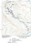
Purpose and ScopeThe purpose of this report is to characterize metal concentrations and identify possible sources contributing metals to Miller Creek during low flow. This study was conducted during August 28-31, 2000. Surface-water samples were collected at 55 mainstem and inflow sites along Miller Creek (fig. 2) and analyzed for pH, major ions, and metals. Streambed-sediment samples were collected at 16 sites and analyzed for metal concentrations. The study reach was about 15,000 ft in length (about 2.8 miles) and covered almost the entire length of Miller Creek. This study was conducted by the U.S. Geological Survey (USGS) in cooperation with the U.S. Department of Agriculture (USDA)-Forest Service.
|
Home page for USGS Water Resources Investigations Report 02-4148
| AccessibilityFOIAPrivacyPolicies and Notices | |
 |
|