Nutrient and Chlorophyll Relations in Selected Streams of the New England Coastal Basins in Massachusetts and New Hampshire, June-September 2001
Nutrients are essential to the health and diversity of surface waters. In excessive amounts, however, they can be harmful. Chronic symptoms of excessive nutrient enrichment include algal blooms, low dissolved oxygen, fish kills, turbid water, and loss of desirable flora and fauna. Human activities that may affect levels of algal biomass include (1) discharge of nutrient-rich wastewater; (2) development that increases impervious surfaces in the drainage basin; (3) reduction of flows; (4) removal of streamside vegetation, which increases light and the flux of nutrients and sediment from riparian zones because of reduced uptake from plants; and (5) construction of residential development with individual septic systems (U.S. Environmental Protection Agency, 2000a).
Factors that control the response of algal biomass to nutrient inputs include hydrologic disturbance, days of algal accrual (Biggs, 2000), light availability (Spahr and Deacon, 1998), turbidity, consumption of algae by invertebrate grazers (Deacon and Spahr, 1998), and possible toxic responses associated with herbicides and other organic contaminants. The importance of any one or any combination of these factors in limiting the growth of algae appears to vary among streams. Nutrient concentrations and light availability, however, often are regarded as the most important factors affecting the primary production in streams that may result in excessive algal growth (Mosisch and others, 1999). Light can be a limiting factor in small streams where there is dense riparian cover. Kjeldsen (1996) found that differences in algal growth between a shaded stream reach and an unshaded stream reach were highly significant (p < 0.05) if the sampling reaches differed only with respect to light availability but the water chemistry and other physical factors remained the same. Welch and others (1992) found that lower than expected algal biomass levels were associated with riparian shading and high macroinvertebrate-grazer densities.
Approaches for assessing the effects of nutrients on algae in streams and rivers are not as well developed as the approaches for lakes. For lakes and reservoirs, a strong quantitative framework has been developed over the past three decades that allows prediction of algal biomass and other water-quality parameters from nutrient loading and nutrient concentrations; however, there is no generally accepted system for classifying streams and rivers (Reckhow, 1979). The U.S. Environmental Protection Agency (USEPA) has developed guidance to assist states in developing nutrient and algal criteria for rivers and streams to protect water quality for designated uses from impairment (U.S. Environmental Protection Agency, 2000a).
Nutrient concentrations that lead to water- quality degradation and impairment of designated use (for example, recreation and aquatic life) differ because of regional variations in geology, climate, and soil types. To be most effective, therefore, water-quality criteria need to take into account ecoregional variations (U.S. Environmental Protection Agency, 2000a). Currently (2003), most states use qualitative criteria based on “best professional judgment” to assess impairment. To control nutrient loading to streams more effectively, however, quantitative nutrient criteria would be valuable to water-resources managers. The numerical criteria could translate qualitative criteria into quantitative endpoints and range along the transition from a desirable mesotrophic (moderately enriched) condition to an undesirable eutrophic condition.
The USEPA has established preliminary recommendations for reference concentrations of total nitrogen and total phosphorus in rivers and streams for ecoregions of the country. These concentrations represent the 25th-percentile concentrations of nitrogen and phosphorus for all sites, which are expected to prevent nuisance algal growths. Concentration thresholds based on the 25th percentile from all sites for USEPA subecoregion 59 (the region of this study) are 0.57 milligram per liter (mg/L) for total nitrogen (dissolved nitrite + nitrate + total ammonia + organic nitrogen) and 0.024 mg/L for total phosphorus (phosphorus in an unfiltered water sample) (U.S. Environmental Protection Agency, 2000b). Another method is to choose the 75th percentile of concentrations of total nitrogen and total phosphorus from a reference population of streams that are minimally affected. Analyses of national nutrient data to date indicate that the 25th percentile from an entire population roughly approximates the 75th percentile for a reference population (U.S. Environmental Protection Agency, 2000b). Although the USEPA did not publish preliminary recommendations for concentrations of periphyton chlorophyll a to maintain suitable levels of algal growth in streams, according to Biggs (1996), streams with chlorophyll a concentrations of 100 milligrams per square meter (mg/m2) or greater for periphyton are generally characterized as eutrophic.
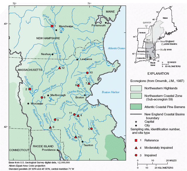
Currently, because of the lack of nutrient and algal data for New England streams, it is difficult to define a precise range of nitrogen and phosphorus concentrations that would promote excessive algal growth and result in water-quality impairments. In an effort to define such a range for the New England Coastal Basins (fig. 1), the U.S. Geological Survey (USGS) National Water-Quality Assessment Program (NAWQA) performed a study from June through September 2001 to derive more quantitative relations between total nitrogen and total phosphorus to periphyton chlorophyll a in wadeable streams in the Northeastern Coastal Zone (fig. 1).
|
| Figure 1. Sampling sites, site-identification numbers, and site types in the New England Coastal Basins study area in Massachusetts and New Hampshire. (Site identification numbers are show in table1.) |
|
Table 1. Selected characteristics for the study
sites in the New England Coastal Basins study area in Massachusetts and New
Hampshire [No., number; fig., figure; mi2, square mile; --, no impairment designation; latitude and longitude are given in degrees �, minutes ', and seconds "] |
||||||||
| Site No. ( fig. 1 ) | Site name | USGS station No. | Site type | Impairment justification | Canopy | Latitude | Longitude | Drainage area (mi2) |
|---|---|---|---|---|---|---|---|---|
| 1 | Black Brook, Dunbarton Road near Manchester, N.H. | 01090477 | Reference | -- | Open4 Closed5 |
43�01'31" | 71�30'17" | 20.72 |
| 2 | Stillwater River near Sterling, Mass. | 01095220 | Reference | -- | Open Closed |
42�24'39" | 71�47'30" | 31.6 |
| 3 | Charles River at Maple Street at North Bellingham, Mass. | 011032058 | Impaired | 305b report1
303d list2 |
Closed | 42�07'11" | 71�27'10" | 21.0 |
| 4 | East Branch Neponset River at Canton, Mass. | 01105504 | Moderately impaired |
Nutrients exceed standards3 | Closed | 42�09'31" | 71�09'17" | 28.13 |
| 5 | Matfield River at North Central Street at East Bridgewater, Mass. | 01106468 | Impaired | Nutrients greatly exceed standards | Open Closed |
42�02'01" | 71�58'21" | 30.61 |
| 6 | Mill River at Summer Street near Blackstone, Mass. | 01112262 | Moderately impaired |
Nutrients exceed standards | Open Closed |
42�02'27" | 71�30'56" | 28.46 |
| 7 | Saugus River at Saugus Ironworks at Saugus, Mass. | 01102345 | Moderately impaired |
Nutrients exceed standards | Closed | 42�28'05" | 71�00'27" | 23.3 |
| 8 | Aberjona River (head of Mystic River) at Winchester, Mass. | 01102500 | Impaired | 303d list | Closed | 42�26'50" | 71�08'22" | 24.1 |
| 9 | Assabet River at Allen Street at Northborough, Mass. | 01096710 | Impaired | 305b report 303d list |
Open Closed |
42�19'46" | 71�37'48" | 29.5 |
| 10 | Ipswich River at South Middleton, Mass. | 01101500 | Impaired | 305b report 303d list |
Closed | 42�34'10" | 71�01'39" | 44.5 |
| 11 | Neponset River at Norwood, Mass. | 01105000 | Impaired | 305b report 303d list |
Closed | 42�10'39" | 71�12'05" | 34.7 |
| 12 | Stony Brook at School Street at Chelmsford, Mass. | 01096544 | Moderately impaired |
Nutrients exceed standards | Open Closed |
42�37'04" | 71�24'08" | 41.6 |
| 13 | Wading River (head of Threemile River) near Norton, Mass. | 01109000 | Moderately impaired |
Nutrients exceed standards | Closed | 41�56'51" | 71�10'38" | 43.3 |
| 1 U.S. Environmental Protection Agency, 2002, Waterbody
system database for the Clean Water Act for 305(b) reporting. 2 Commonwealth of Massachusetts, Final Massachusetts section 303(d) list of waters, 1998. 3 Previous data shows that site exceeded U.S. Environmental Protection Agency preliminary standards. 4 Sampling site located in an open-canopy section of the stream. 5 Sampling site located in a closed-canopy section of the stream. |
||||||||
The objective of this report is to develop potential methods that could guide water-resource managers in the development of nutrient criteria for New England streams on the basis of water-quality data collected at sites in the New England Coastal Basins study area. This report (1) summarizes water-quality data at selected wadeable streams, (2) examines the response of algae to nutrients and incident light (as measured by tree canopy) from June through September 2001, and (3) provides potential methods for nutrient-criteria development. The results presented are relevant only to the data analysis performed in this study. However, examples are presented in this report of how nutrient criteria could be developed by water-resource managers for the Northeastern Coastal Zone.
The New England Coastal Basins (NECB) study area is a 23,000 square mile (mi2) area that encompasses central Maine, eastern New Hampshire, eastern Massachusetts, and Rhode Island. Major rivers in the NECB study area include the Kennebec, Androscoggin, Saco, Merrimack, Charles, and Blackstone Rivers. Land use in the NECB study area consists of 74 percent forest, 11 percent urban development, 8 percent surface-water bodies, and 6 percent agriculture (Flanagan and others, 1999). A more detailed description of the physical and cultural settings of the NECB study area is found in Flanagan and others (1999). All sites for this specific investigation were in subecoregion 59 of the NECB, which is the Northeastern Coastal Zone (fig. 1).
Thirteen wadeable stream sites, primarily in eastern Massachusetts, were selected on the basis of previous nitrogen, phosphorus, and dissolved oxygen data. Six of the 13 sites were classified as impaired because of existing nutrient problems, low levels of dissolved oxygen, or extensive algal growth. Five of these sites were considered impaired, or not meeting narrative standards, on the basis of the State's 305(b) water-quality report or Clean Water Act 303(d) list (U.S. Environmental Protection Agency, 2002; Commonwealth of Massachusetts, 1999). The sixth site was classified as impaired because previous water samples collected at that site had nutrient concentrations that greatly exceeded preliminary standards. Five additional sites were selected on the basis of previous water-quality data (Karen Beaulieu, U.S. Geological Survey, written commun., 2002). Water samples collected at these sites were categorized as moderately impaired because their total nitrogen and total phosphorus concentrations slightly exceeded preliminary standards for subecoregion 59. Two additional sites were selected to represent reference conditions (table 1, fig. 1).
Riparian zones dominated by trees that provided substantial canopy cover (closed canopy) characterized all 13 sites. Additional locations with increased patchiness of riparian-tree cover provided an unshaded stream-sampling area (open canopy) at 6 of the 13 sites where supplementary periphyton samples were collected to compare with data from the closed-canopy sites.
The authors thank Karen Beaulieu, Kimberly Campo, and Maureen Thomas for their assistance with field work. The authors also thank Stephen Porter, USGS Denver, Colo., and Jacob Gibs, USGS West Trenton, N.J., for their critical review of the manuscript. Appreciation is extended to the following USGS employees: Ann Marie Squillacci for manuscript preparation, Laura Hayes and Anita Cotton for graphics assistance, and Matthew Cooke and Mary Ashman for editorial review of this report.
Next: Data Collection and Analysis
Back: Abstract
| AccessibilityFOIAPrivacyPolicies and Notices | |
 |
|