National Water-Quality Assessment (NAWQA) Program
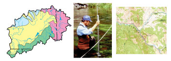
Stream habitat is characterized in the U.S. Geological Survey's National Water-Quality Assessment (NAWQA) Program as part of an integrated physical, chemical, and biological assessment of the Nation's water quality. The goal of stream habitat characterization is to relate habitat to other physical, chemical, and biological factors that describe water-quality conditions. To accomplish this goal, environmental settings are described at sites selected for water-quality assessment. In addition, spatial and temporal patterns in habitat are examined at local, regional, and national scales.
This habitat protocol contains updated methods for evaluating habitat in NAWQA Study Units. Revisions are based on lessons learned after 6 years of applying the original NAWQA habitat protocol to NAWQA Study Unit ecological surveys. Similar to the original protocol, these revised methods for evaluating stream habitat are based on a spatially hierarchical framework that incorporates habitat data at basin, segment, reach, and microhabitat scales. This framework provides a basis for national consistency in collection techniques while allowing flexibility in habitat assessment within individual Study Units. Procedures are described for collecting habitat data at basin and segment scales; these procedures include use of geographic information system data bases, topographic maps, and aerial photographs. Data collected at the reach scale include channel, bank, and riparian characteristics.
This report is available online in Portable Document Format (PDF). If you do not have the Adobe Reader, it is available for free download from Adobe Systems Incorporated.
Document Accessibility: Adobe Systems Incorporated has information about PDFs and the visually impaired. This information provides tools to help make PDF files accessible. These tools convert Adobe PDF documents into HTML or ASCII text, which then can be read by a number of common screen-reading programs that synthesize text as audible speech. In addition, an accessible version of Adobe Reader 8.0 for Windows (English only), which contains support for screen readers, is available. These tools and the accessible reader may be obtained free from Adobe at Adobe Access.
For further information about this report, contact the National Water-Quality Assessment Program office.
| AccessibilityFOIAPrivacyPolicies and Notices | |
 |
|