Twelve monitoring wells were installed in 1997 at seven sites in and near Oasis Valley, Nevada. The wells, ranging in depth from 65 to 642 feet, were installed to measure water levels and to collect water-quality samples. Well-construction data and geologic and geophysical logs are presented in this report. Seven geologic units were identified and described from samples collected during the drilling: (1) Ammonia Tanks Tuff; (2) Tuff of Cutoff Road; (3) tuffs, not formally named but informally referred to in this report as the "tuff of Oasis Valley"; (4) lavas informally named the "rhyolitic lavas of Colson Pond"; (5) Tertiary colluvial and alluvial gravelly deposits; (6) Tertiary and Quaternary colluvium; and (7) Quaternary alluvium. Water levels in the wells were measured in October 1997 and February 1998 and ranged from about 18 to 350 feet below land surface. Transmissive zones in one of the boreholes penetrating volcanic rock were identified using flowmeter data. Zones with the highest transmissivity are at depths of about 205 feet in the "rhyolitic lavas of Colson Pond" and 340 feet within the "tuff of Oasis Valley."
Between 1957 and 1992, 828 underground tests consisting of 921 underground nuclear detonations were reported beneath the Nevada Test Site (NTS), most in Pahute Mesa, Rainier Mesa, and Yucca Flat (U.S. Department of Energy, 1994). These nuclear devices were detonated underground to contain their explosive force and radioactive by-products. Although water levels in the NTS region are generally more than 800 ft below land surface, many of the intermediate- and large-yield devices were detonated at depths near or below the water table. Some of these detonations have resulted in the introduction of radioactive and chemical contaminants into the regional ground-water flow system (Laczniak and others, 1996).
The investigation and remediation of radioactive and other contaminants at the NTS are the focus of the U.S. Department of Energy (USDOE) Environmental Restoration Program (U.S. Department of Energy, 1991). One of the objectives of the long-term program is to assess the extent of contamination on, and potentially off, the NTS. The U.S. Geological Survey (USGS) is contributing to this objective by providing USDOE with a hydrogeologic understanding of the NTS and vicinity. The USGS is involved with drilling and monitoring test wells for geologic, hydrologic, and chemical characterization. The information from these characterizations is used to identify ground-water flow paths and quantify ground-water flow through areas of interest. A more complete understanding of the ground-water flow system on and adjacent to the NTS will provide for future evaluation of environmental risks and remediation strategies.
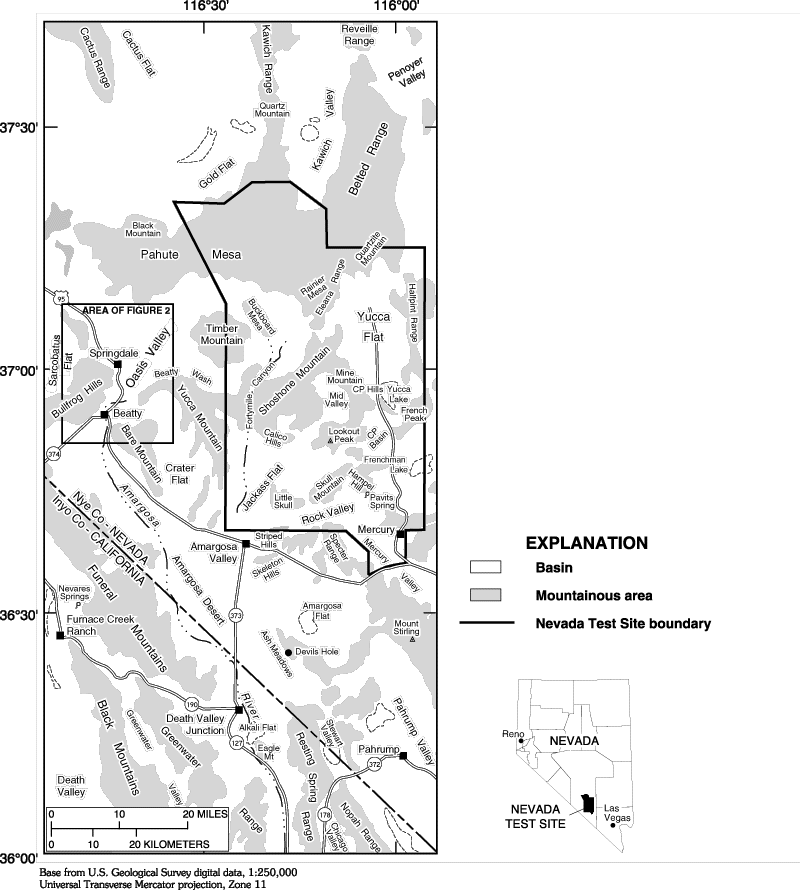
Oasis Valley is a USDOE area of concern because it is downgradient from Pahute Mesa, one of the sites of intensive underground nuclear testing (fig. 1). Because ground water from parts of western and central Pahute Mesa may discharge into Oasis Valley (Laczniak and others, 1996), the USGS installed a network of wells in the valley to help characterize the geology and understand the ground-water flow system. Additionally, water-quality samples were collected from these wells during November 3-19, 1997, by the following agencies (types of analyses are listed after agency name): USGS (dissolved organic carbon, chlorofluorocarbons, and strontium and uranium isotopes); Lawrence Livermore National Laboratory (noble gasses, tritium, and dissolved inorganic carbon); Desert Research Institute (major ions, deuterium, oxygen-18, and dissolved inorganic carbon); HSI-GeoTrans, Inc. (trace elements); and State of Nevada, Department of Environmental Protection (radionuclides). Waterquality data are not included in this report. The wells in Oasis Valley have been incorporated as part of a regional NTS ground-water-monitoring network under the USDOE Environmental Restoration Program.
The purpose of this report is to present geologic, geophysical, and hydrologic data obtained from the drilling of test holes in Oasis Valley in support of the USDOE Environmental Restoration Program at the NTS. The report documents drilling procedures and well-completion information for the 12 monitoring wells that were installed in 11 test holes during 1997. A geologic interpretation for each test hole is provided. Hydrologic information presented consists of two sets of water levels measured in October 1997 and one set in February 1998, and data obtained from a heat-pulse flowmeter in well ER-OV-06a. The relative transmissivities of different water-bearing zones in this well are interpreted from the flowmeter data.
The study area is the central part of the Oasis Valley Hydrographic Area1, about 14 mi west of NTS. The altitude of Oasis Valley ranges from approximately 3,500 to 4,000 ft above sea level. From its southern extent near Beatty, Nev., the valley trends north-northwest for approximately 14 mi (figs. 1 and 2). The valley is bounded by Pahute Mesa on the north, Oasis Mountain and the Bullfrog Hills on the west, Bare Mountain on the south, and Timber Mountain and Beatty Wash on the east and southeast. The Amargosa River, an ephemeral steam, flows south through the center of the valley. Although the river is usually dry, local seeps provide for wetlands along its course. Beatty Wash, an ephemeral tributary to the Amargosa River, flows only during periods of heavy rain. Hot and cold springs are found within the Amargosa River valley and some of the tributary drainages.
Approximately 1,600 of the 4,200 people living in Oasis Valley on July 1, 1997, were residents of Beatty (State Demographer, State of Nevada, written commun., 1998). The remainder of the population is distributed throughout the valley between Beatty and Springdale. The town of Springdale, about 8 mi north of Beatty, has a population of about 75.
The rocks of hydrogeological significance that underlie the region surrounding Oasis Valley are grouped into several major units. These include a sequence of Paleozoic and older sedimentary and metamorphic rock (600 to 280 million years before present [Ma]), an assemblage of Miocene volcanic rocks (16 to 8 Ma), and locally thick deposits of post-volcanic valley fill composed of gravel, sand, and silt (fig. 3).
The Paleozoic and older rocks in this region consist of (1) a basement unit and (2) a younger regional carbonate-rock unit (Laczniak and others, 1996). The rocks that make up the basement unit consist of quartzite, micaceous quartzite, siltstone, and dolomite of Cambrian and older age. The regional carbonate-rock unit consists of about 15,000 ft of limestone, dolomite, and some shale and quartzite, of Cambrian through Devonian age.
The Miocene volcanic rocks were deposited along an east-trending belt of several partly overlapping caldera or caldera complexes (fig. 3), which were subsequently filled by lava and vast blankets of tuff. The volcanic activity took place between 16 and 8 Ma, overlapping the latter phases of Basin and Range extensional faulting (Byers and others, 1976; Hamilton, 1988; Wernicke and others, 1988; Sawyer and others, 1994). Deposits associated with the caldera complexes include glassy and crystalline lava flows; air-fall, ash-flow, and reworked tuffs; and tectonic, eruptive, and flow breccias. These rocks vary in age, composition, amount of hydrothermal alteration, and diagenesis. Principle volcanic rocks in Oasis Valley consist of rhyolitic lava and variably welded ash-flow tuffs of the Timber Mountain Group and the Thirsty Canyon Group. Extensional faulting during and after the eruptions caused tilting and lateral crustal-block movement.
Alluvial deposits are the dominant fill in Oasis Valley and other basins that formed as a result of the extensional faulting. The basins contain gravel, sand (eolian and fluvial), silt, clay, and locally fine-grained playa-lake deposits. In the northeastern part of Oasis Valley, the thickness of basin fill (referred to as alluvium) ascertained from drilling logs and from geophysical studies, ranges from 0 to more than 830 ft (G.L. Dixon, U.S. Geological Survey, written commun., 1997).
Oasis Valley is centrally located within the Death Valley ground-water flow system, one of the major hydrologic subdivisions of the southern Great Basin (Harrill and others, 1988). An estimated 70,000 acre-ft of ground water flows through the system annually (Blankennagel and Weir, 1973; Winograd and Thordarson, 1975; Harrill and others, 1988; Dettinger, 1989). Most ground water moves through the thick sequences of volcanic and carbonate rocks, from high-altitude areas of recharge north and east of Oasis Valley, toward areas of surface discharge at Oasis Valley, Ash Meadows, Alkali Flat, and Death Valley. Ground water has been used for domestic and public supplies, agriculture, and mining at many locations in the valleys. In addition, springs and seeps in these valleys sustain wetlands, which support a variety of wildlife.
Recharge for the Oasis Valley ground-water basin is derived primarily from precipitation that falls on mountain ranges to the north, which may include the Cactus Range, Quartz Mountain, Black Mountain, and the western part of Pahute Mesa (Laczniak and others, 1996). Annual discharge in Oasis Valley was estimated by Malmberg and Eakin (1962) to be 2,000 acre-ft. Blankennagel and Weir (1973) suggested that rates may be two to three times higher than that. Outflow from Oasis Valley is thought to be controlled by a basement confining unit of clastic siliceous rocks, which crops out near Oasis Valley. The confining unit may divert water upward through faults in the area (Laczniak and others, 1996).
The major regional aquifers have been designated (1) the carbonate-rock aquifer, (2) the volcanic-rock aquifer, and (3) the valley-fill aquifer (Laczniak and others, 1996). The carbonate-rock aquifer is the primary aquifer within the Death Valley flow system because of its high transmissivity and large areal extent. It is underlain by the basement unit, which forms a lower confining zone. In places, the carbonate-rock aquifer is confined on top by the Eleana Formation; in other locations the Eleana Formation divides the aquifer into two parts--a lower and an upper carbonate-rock aquifer. In places where the confining unit is not present, the carbonates function as a single aquifer.
A series of complexly interbedded volcanic-rock aquifers and confining units overlie the carbonate-rock aquifer. The volcanic-rock aquifers consist of dense, highly fractured, welded tuffs outside the calderas and highly fractured lava flows and thick welded tuff bodies within the calderas. The volcanic confining units tend to be zeolitically altered, non-welded tuff units (Winograd and Thordarson, 1975; Byers and others, 1976).
Valley-fill aquifers have high porosity and permeability; however, they are commonly unsaturated or have little saturated material. In the northwestern part of Oasis Valley, the maximum saturated thickness of alluvium determined from well logs, static water levels, and geophysical studies is about 470 ft (G.L. Dixon, U.S. Geological Survey, written commun., 1997). Along the Amargosa River within the valley, data from well logs indicate the saturated thickness is greater than 150 ft.
This study was made in cooperation with the U.S. Department of Energy (Interagency agreement DE-AI08-96NV11967). The authors express their appreciation to the following individuals for their support during this study. Jeffery D. Eman and John C. Palmer, U.S. Geological Survey Central Region Drill Rig crew members, drilled and constructed all the wells in the heat of August and September. The following USGS personnel--Kevin D. Knutson, Barbara S. Corland, Richard E. Hodges, Thomas A. Wickham, Owen D. Young, and Douglas K. Maurer--did geophysical logging, on-site geology, and other work necessary to complete the drilling. Thomas Spicer allowed access to the sites through his property and allowed the water tanker to be filled from his supply. The Beatty Sanitation District allowed the storage of drilling supplies at their facility.
Footnote:
1 Formal hydrographic areas in Nevada were delineated systematically by the U.S. Geological Survey and Nevada Division of Water Resources in the late 1960's (Rush, 1968; Cardinalli and others, 1968) for scientific and administrative purposes. The official hydrographic-area names, numbers, and geographic boundaries continue to be used in Geological Survey scientific reports and Division of Water Resources administrative activities.
Table of Contents || Next Section: Well Drilling || Well Logs
The pathname for this page is <text1.htm>
These pages are maintained by S.C. DeMeo <email:
scdemeo@usgs.gov>
Last modified Monday, March 15,
1999 02:49 PM