 |
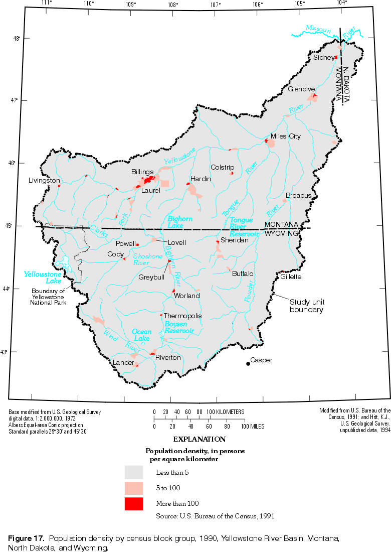
| Figure 17. Population density by census block group,
1990, Yellowstone River Basin. (Click on image for a larger version, 87 kb) |
The term "anthropogenic" means of, relating to, or involving the impact of humans on nature. Because human practices are the source of many water-quality contaminants in the YRB, they must be described as an integral part of the environmental setting. Agricultural runoff, urban runoff, point discharges of municipal and industrial wastes, mine drainage, septic-system effluent, landfill leachate, and contaminated atmospheric deposition are all sources of anthropogenic contamination in the study unit. These sources are directly related to population density, land cover and land use, water use, and waste disposal in the YRB. The major contaminants associated with human activities are summarized in table 8.
Table 8. Human activities contributing to contamination of surface and ground water
(modified from Risser and Siwiec, 1996, table 16)
|
Activity |
Contaminants frequently cited as results of activity |
Other remarks |
|---|---|---|
|
Land-use activities |
||
|
Agricultural activities: applications of commercial fertilizers, manure, and pesticides |
Nitrate, phosphate, bacteria, and pesticides |
Surface erosion washes chemical residues into streams; infiltrating water transports dissolved contaminants to ground water |
|
Mining activities: mining and spoil disposal |
Acids, iron, manganese, sulfate, uranium, thorium, radium, molybdenum, selenium, and other trace elements |
Leachates from spoil piles of coal, metallic-, and nonmetallic-mineral mining contain a variety of contaminants |
|
Urban activities |
Bacteria, hydrocarbons, dissolved solids, lead, cadmium, and other trace elements |
Urban runoff washes contaminants into streams; infiltration from detention basins and drainage wells can reach ground water |
|
Storage tanks |
Petroleum products, acids, metals, and organic compounds |
Useful life of steel tanks is 15-20 years; leaks, spills, and overflows may contaminate ground water |
Waste disposal |
||
|
Septic systems |
Bacteria, viruses, nitrate, phosphate, chloride, and synthetic organic compounds |
None |
|
Landfills |
Dissolved solids, iron, manganese, trace elements, acids, organic compounds, and pesticides |
Traditional disposal method used for municipal and industrial waste; number of abandoned landfills and dumps is unknown |
|
Surface impoundments |
Manure, trace elements, and organic compounds |
Used to store agricultural wastes, industrial liquid wastes, municipal sewage sludge, and other wastes |
|
Injection wells |
Dissolved solids, bacteria, sodium, chloride, nitrate, phosphate, organic compounds, pesticides, and acids |
Hazardous wastes also were injected in the past |
|
Surface applications of waste |
Bacteria, nitrate, phosphate, trace metals, and organic compounds |
Waste disposal from municipal sewage-treatment plants, septic systems, and drinking-water treatment plants |
|
Discharges from sewage-treatment plants |
Bacteria, nitrate, ammonia, phosphate, organic compounds, and suspended solids |
Base flow in receiving water body may be inadequate for proper dilution |
|
Industrial discharges |
Organic compounds and trace elements |
Treated effluent in many cases; discharged to surface water |
The early human populations of the YRB included the Crow Nation, which had pushed westward as far as the mouth of the Bighorn River in the mid-1700s, and by 1800 had displaced the Shoshone Tribe throughout the entire upper YRB (U.S. Department of the Interior, 1965). Fur trappers considered the YRB a prime area of production from 1805-35. However, permanent settlement by non-Native populations coincided with the mining booms, cattle drives, and westward railroad construction beginning in the 1860s. In 1874, commercial river boats began service on the Yellowstone River as far upstream as present-day Billings, but were abandoned in 1884, 2 years after the railroad reached Billings (U.S. Department of the Interior, 1965). The frontier was considered closed by 1890, and within another 20 years much of the YRB achieved its maximum population density to date (Missouri Basin Inter-Agency Committee, 1969).
From 1900-90, the rate of population growth in this region has lagged behind the National average. The YRB is sparsely populated (fig. 17), and the population was relatively stable during the decades preceding 1990. Population density in 1960 was less than two persons per km2 (Missouri Basin Inter-Agency Committee, 1969). From 1980-90 the population of the study unit decreased by about 2 percent (U.S. Bureau of the Census, 1980; 1991), and averaged less than two persons per km2 in 1990.
|
| Figure 17. Population density by census block group,
1990, Yellowstone River Basin. (Click on image for a larger version, 87 kb) |
According to the 1990 census, about 323,000 people resided in the study unit on April 1, 1990. The population distribution by State is 206,000 people in Montana, 116,000 people in Wyoming, and 1,000 in North Dakota. The major population center of the study unit is the Billings, Mont., metropolitan area, with a population of 113,419 in 1990 (U.S. Bureau of the Census, 1997c). No other cities in the YRB had a 1990 population greater than 14,000 residents (U.S. Bureau of the Census, 1997b). Gateway communities to Yellowstone National Park do not have a large resident population, but a substantial temporary population of visitors is typically present because of tourism and recreational opportunities. The summer seasonal peak of temporary population is pronounced.
Population within the study unit is estimated to have increased by 8.4 percent since 1990 to about 350,000 by July 1, 1996. These population increases have been centered in several areas experiencing rapid growth, largely by the conversion of ranch land to low-density residential use. During 1990-96, the six county area generally corresponding to the northwestern YRB experienced an 11 percent increase in estimated population--an increase of about 19,000 residents, and about half of this growth occurred in Billings (U.S. Bureau of the Census, 1997a; 1997b). Several Wyoming communities along the eastern front of the Bighorn Mountains also have had 1990-96 population growth, averaging nearly 8 percent (U.S. Bureau of the Census, 1997b).
Land-cover and land-use maps indicate the spatial distribution of management practices likely to affect the quality of water resources (Gallant and others, 1989). Activities such as grazing, logging, and mining on rangeland and forest land may affect water quality by increasing suspended-sediment loads and concentrations of metals or nutrients, and by altering hydrologic conditions. Pesticide and fertilizer applications, crop rotation, and tillage practices may affect both surface-water and ground-water quality on agricultural land. Water quality in urban areas is subject to runoff, pesticide and fertilizer usage, and waste disposal.
The available USGS data for land cover and land use (U.S. Geological Survey, 1986) are relatively detailed but also somewhat dated. The 1- by 2-degree quadrangles covering the YRB study unit were interpreted from aerial photography acquired during 1970-84 (U.S. Geological Survey, 1976-85). The USGS data (1:250,000 scale) are not a large-scale source, yet were the most spatially detailed with consistent coverage of the entire study unit. At the most general level of classification (Anderson and others, 1976), the land cover and land use of the YRB are shown in figure 18.
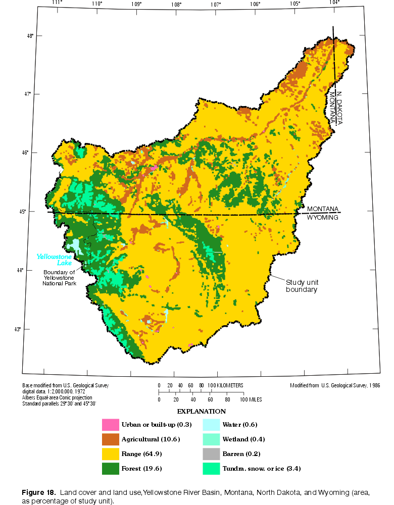 |
| Figure 18. Land cover and land use, Yellowstone
River Basin. (Click on image for a larger version, 87 kb) |
Agricultural, urban, and mineral-related land uses are discussed in separate sections that follow. Silviculture is another potentially important land-use activity. Forests cover about 20 percent of the YRB (U.S. Geological Survey, 1986). Most of the timber resources of the YRB are contained within the National Forest System lands. Each national forest has developed a Forest Plan that specifies the maximum volume of timber that may be sold from the suitable timber base during the specified planning period. For example, the allowable sale quantity (ASQ) of timber established by the 1986 Forest Plan of the Shoshone National Forest (fig. 19) was 11.2 million board feet per year on a suitable timber base of about 350 km2 (U.S. Dept. of Agriculture, Forest Service, 1997) (One board foot equals 0.0929 m2 [one foot square] by 25.4 mm [1 inch] thick). Following the wildfires of 1988, ASQs of timber were revised for some areas due to extensive burning of the timber base. Shoshone National Forest is currently using an ASQ of about 4.5 million board feet per year, and an additional 2.3 million board feet of other products (fuelwood, posts, and poles) are sold annually (U.S. Dept. of Agriculture, Forest Service, 1997).
 |
| Figure 19. Indian reservations, national forests and grasslands, and national parks and recreation areas, Yellowstone River Basin. (Click on image for a larger version, 92 kb) |
Agricultural activities, primarily livestock production and irrigated and dryland crop production, are the most areally extensive land-use industries in the study unit. Rangeland is the dominant land cover, with about 43 percent of the study unit composed of subhumid grassland and semiarid grazing land, about 16 percent grazed desert shrubland, and about 5 percent grazed open woodland. Cropland and pasture compose only about 11 percent of the study unit (U.S. Geological Survey, 1986), with about 36 percent of the harvested cropland in 1987 having been irrigated (Battaglin and Goolsby, 1994). Most irrigated cropland is located in the principal stream valleys.
The effects of agriculture on sediment, nutrient, bacteria, and pesticide concentrations are water-quality issues in the study unit. Grazing, especially when pasture or rangeland are stocked near or above their carrying capacities, has been shown to increase runoff and soil erosion as vegetative land cover decreases and stream banks become trampled (Owens and others, 1996). Even near-natural rangelands, such as those within national parks, may be subject to overgrazing, particularly when humans apply various management strategies to modify populations of herbivorous wildlife (Coughenour and Singer, 1991).
According to the 1987 Census of Agriculture, 9,584 farms covered 117,367 km2 in the YRB, of which 4,023 km2 was irrigated land. Cropland accounted for 15,011 km2 of this area, in which wheat (2,891 km2), alfalfa (2,231 km2), barley (1,249 km2), hay other than alfalfa (1,089 km2), corn (268 km2), oats (214 km2), and sugar beets (165 km2) were the principal crops harvested (Battaglin and Goolsby, 1994). A total of 8,360 km2 of cropland was harvested in 1987. Pasture, along with 1,971 km2 of woodland, composed the remainder of the farmland. The predominant crop rotation in the Wyoming part of the YRB is barley and sugar beets, with some producers also including corn and alfalfa as part of their rotation (P. Shelton, USDA Natural Resources Conservation Service, Casper, Wyo., written commun., 1998).
Commercial fertilizers (see table 9) were applied to 4,758 km2 of cropland. Estimates of commercial fertilizer usage do not include manure applications. Nutrients from manure are a potential problem because animal densities are high in localized areas. Although records are not kept of manure applications, the domestic livestock in the study unit (table 10) are counted regularly. Cattle raised for beef are the most numerous group of domestic livestock, followed by sheep, hogs, and poultry.
Table 9. Estimated annual applications of fertilizers in the Yellowstone River Basin
(Modified from Battaglin and Goolsby, 1994)
|
Fertilizer used |
Estimated application of active ingredient during 1987, in kilograms |
|---|---|
|
Nitrogen fertilizers: |
|
|
Anhydrous ammonia |
32,750,529 |
|
Urea |
7,009,657 |
|
Miscellaneous forms |
6,545,967 |
|
Nitrogen solutions |
6,254,551 |
|
Ammonium nitrate |
5,244,132 |
|
Total nitrogen fertilizer |
57,807,019 |
|
Phosphate |
19,309,058 |
|
Potash |
3,338,697 |
Table 10. Livestock numbers in the Yellowstone River Basin, 1987
(Modified from Battaglin and Goolsby, 1994)
|
Type of livestock |
Number raised |
|---|---|
|
Cattle and calves |
1,131,373 |
|
Beef cows |
565,762 |
|
Steers, steer calves, bulls, and bull calves |
266,136 |
|
Milk cows |
6,846 |
|
Sheep and lambs |
510,436 |
|
Horses and ponies |
36,960 |
|
Hogs and pigs |
35,810 |
|
Chickens (3 months or older) |
20,583 |
|
Hens and pullets of laying age |
14,182 |
|
Broilers and other meat-type chickens |
4,459 |
|
Turkeys |
1,247 |
Chemical pesticides often are applied to agricultural lands to control weeds, insects, and fungus. Applications to field crops are the dominant agricultural use of pesticides, followed by applications to pastures. Many of the chemical compounds applied are soluble in water and may be leached from the soil into surface or ground water.
The NAWQA program analyzed information on national and regional patterns of pesticide occurrence in surface water of the United States and the major influences on the sources and transport of pesticides (Larson and others, 1997). The following points are known in relation to surface water:
Low levels of pesticides have been widespread in the Nation's surface water for several decades.
Pesticide concentrations in surface water follow strong seasonal patterns that result from the timing of pesticide applications and runoff conditions.
Many pesticides are rarely detected in surface waters because of relatively low use, how they are applied, chemical properties, or relatively insensitive analytical methods.
In many streams, some pesticides exceed water-quality criteria for seasonal periods each year,
but annual average concentrations seldom exceed regulatory standards for drinking water.
Potential effects of pesticides on humans and aquatic ecosystems are difficult to evaluate because of inadequate information on effects of low-level mixtures, transformation products, and seasonal exposure.
Improved information is needed on long-term trends, pesticides and transformation products that have not been widely measured, and biological effects of typical exposure patterns.
NAWQA also analyzed information on national and regional patterns of pesticide occurrence in ground water of the United States and the major influences on the sources and transport of pesticides (Barbash and Resek, 1996). The following points are known in relation to ground water:
Pesticides from every major chemical class have been detected in ground water.
Pesticides are commonly present in low concentrations in ground water beneath agricultural areas, but seldom exceed water-quality standards.
Frequencies of pesticide detection are almost always low in low-use areas, but vary widely in areas of high use.
Pesticide levels in ground water show pronounced seasonal variability in agricultural areas, with maximum values often following spring applications.
Factors most strongly associated with increased likelihood of pesticide occurrence in wells are high pesticide use, high recharge by infiltration of either precipitation or irrigation, and shallow, inadequately sealed, or older wells.
NAWQA also analyzed information on national and regional patterns of pesticide occurrence in the atmosphere and the major influences on the sources and transport of pesticides (Majewski, 1995). The following points are known in relation to the atmosphere:
Existing data, gleaned from 132 studies, are unevenly distributed, with most of the data from the Great Lakes region and California.
Most of the pesticides studied have been detected in rain or air, but many that are used have never been studied.
Pesticides have been detected in the atmosphere in all areas of the Nation sampled.
Concentrations of a pesticide in air and rain are most affected by its use and resistance to environmental degradation.
The highest atmospheric concentrations of pesticides occur seasonally in high-use areas when applications are greatest.
Low levels of long-lived pesticides are present in the atmosphere throughout the year.
Atmospheric deposition of pesticides is most likely to affect stream-water quality during runoff events when precipitation and direct surface runoff are the major sources of streamflow, but the full significance to water quality is largely unknown.
Within the study unit, the small area devoted to row crops (sugar beets, corn, and beans, primarily) is reflected by the types and amounts of herbicides that are most widely used in the YRB (table 11). The chlorinated phenoxy 2,4-D is used mainly as a postemergence herbicide on grassland, small grains, and fallow land (Meister, 1996). Dicamba is a benzoic acid used to control broadleaf weeds in asparagus, corn, grassland, fallow land, and small grains; picloram is used on broadleaf weeds in small grains and pastures, and for brush control on rangeland and utility rights-of-way; cycloate is a selective herbicide used for sugar beet production; EPTC is effective on grassy weeds and some broadleaf weeds in beans and potatoes; triallate is a selective herbicide for use in producing small grains and some beans and peas (Meister, 1996).
Table 11. Estimated annual applications of the 12 most extensively used herbicides in the Yellowstone River Basin
(Data from Battaglin and Goolsby, 1994)
|
Pesticide |
Estimated application of active ingredient, in kilograms |
|---|---|
|
2,4-D |
308,184 |
|
dicamba |
127,223 |
|
picloram |
76,611 |
|
cycloate |
64,885 |
|
EPTC |
60,017 |
|
triallate |
57,883 |
|
MCPA |
17,634 |
|
2,4-DB |
14,526 |
|
diethatyl-ethyla |
10,189 |
|
alachlor |
9,566 |
|
ethofumesate |
7,152 |
|
cyanazine |
6,156 |
aDiscontinued by manufacturer in 1993.
The largest concentrations of pesticides detected in air and rain occur in those areas where they are used most frequently and in the largest quantities. Patterns of atmospheric pesticide concentrations from the early 1970s showed general correlations among atmospheric concentrations and regional use and cropping patterns (Majewski, 1995). Atmospheric pesticide concentrations within the YRB were low relative to areas of the Nation that have more intensive agricultural activity and more extensive cropland.
Urban and residential areas affect surface- and ground-water quality by altering the physical hydrology and by adding waste products. Streamflow and ground-water flow are altered where rooftops, paved surfaces, and sewers accelerate the movement of storm runoff to streams at the expense of ground-water infiltration. Urban runoff frequently carries large nonpoint-source loads of sediment and inorganic and organic constituents from paved surfaces, parks, lawns, and golf courses. Point sources of contamination from the populated urban environment include sewage-treatment facilities, industrial discharges, landfills, and leaking storage tanks. Contamination of ground water by volatile organic compounds is a special concern because of its widespread occurrence in urban areas (Risser and Siwiec, 1996).
Urban or built-up land accounts for only 0.3 percent of the study unit area. However, in this small area there are a large number of point sources having the potential to contaminate receiving waters. The U.S. Environmental Protection Agency (USEPA) regulates 341 facilities in Billings, Montana. These facilities include National Pollutant Discharge Elimination System permit holders, hazardous waste handlers, Superfund sites, facilities releasing and transferring toxic chemicals, and sources of air pollution.
Herbicides, pesticides, and fertilizers are sometimes applied to urban land at greater rates than typically applied to agricultural land and can contribute to water-quality impairment. Lawns, gardens, parks, and golf courses are subject to intense pesticide applications. NAWQA determined that the most commonly detected insecticides in streams across the U.S. have substantial urban and suburban use (Larson and others, 1997).
Recent population growth in urban and suburban areas of the YRB represents potential water-quality problems. As sparsely populated grazing land is converted to residential use, there is increased risk of water supplies becoming contaminated. Many housing developments rely on septic systems from which contaminants can leach into the ground-water supply.
In addition to agriculture and urban uses, other important land uses in the study unit include metals and coal mining and hydrocarbon production. These mineral industries are discussed in the following sections.
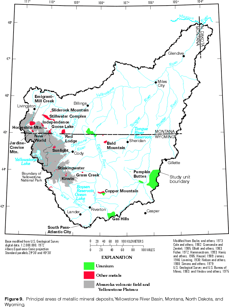
Metals Mining--The study unit contains few of the historically most productive metals mines in either Montana or Wyoming. However, there are some substantial deposits of metallic minerals within the YRB (fig. 9), and several areas experienced mining-related impacts. Potential water-quality problems associated with metals mining are increased sedimentation and the discharge of mine drainage that often exhibits water chemistry substantially different from the natural chemistry of the receiving water body. Mine dumps and tailings ponds are additional sources of potential concern. Surface-water quality could be affected by detention ponds used at uranium mines and tailings ponds at mills, but if operated properly, adverse effects are not likely (Lowry and others, 1993).
Metal deposits are known in some areas of the structural basins and at locations related to Cretaceous and Tertiary intrusions, but the Precambrian crystalline rocks have been the primary targets of prospectors and geologists seeking metallic ores. Early exploration for precious metals in the YRB led to the subsequent discovery of gold placer deposits in the vicinity of South Pass, Wyo. (fig. 9), in 1842, and in several tributaries of the upper Yellowstone River in the 1860s. However, lode deposits were not substantially developed until the 1860s near South Pass (Hausel, 1991) and in the 1870s at the Jardine and New World districts (fig. 9) of Montana (Hammarstrom and others, 1993a). Nickel, copper, and chromite deposits in the Precambrian Stillwater Complex (fig. 9) of Montana were discovered during 1883-90 (Hammarstrom and others, 1993a).
Historically, mines in the study unit have produced gold, silver, arsenic, tungsten, copper, lead, zinc, and chromium from lode deposits, as well as gold from placer deposits (Hammarstrom and others, 1993). But within the past 55 years, iron, chromium, uranium, and platinum have been the most important metallic mineral products of the YRB. The Atlantic City surface mine produced more than 80 million megagrams of iron ore from 1962 until operations ceased in 1983 (Hausel, 1984). (Although the Atlantic City mine pit lies just outside the study unit, part of the mine dump extends into the YRB [Hausel, 1991, plate 1], and is a potential influence on water quality in the study unit.) Some chromite was mined from the Stillwater Complex during and after World War II to provide government stockpiles of critical minerals (Hammarstrom and others, 1993), but large-scale chromite mining occurred during 1953-61 (Hammarstrom and others, 1993a). From the discovery of uranium in Tertiary sedimentary rocks in the early 1950s (Houston, 1979) until the rapid decline of the industry by the mid-1980s (Lowry and others, 1993), millions of megagrams of uranium ore were mined in the study unit. Development of the platinum-group elements (PGE) deposits of the Stillwater Complex began in the 1960s (Hammarstrom and others, 1993a).
In recent years, only four commercial mines have produced metallic ores in the study unit: (1) the Stillwater mine is producing PGE, gold, copper, and nickel from the Stillwater Complex (fig. 9); (2) the Mineral Hill mine had been producing gold and silver from lode deposits in the Jardine district (Hammarstrom and others, 1993) (fig. 9); (3) the Christiansen Ranch operation, an in-situ uranium producer located about midway between Casper and Gillette, is active (Harris, 1997); and, (4) a few kilometers north, the Irrigary uranium mine has become inactive recently (Anderson and others, 1993; R.E. Harris, Wyoming State Geological Survey, oral commun., 1998). The underground Stillwater mine recently expanded operations in order to increase the production goal to 1,800 megagrams per day. Closure of the Mineral Hill mine was recently announced (U.S. Geological Survey, 1997a). In the New World district, a proposed new project (underground mining of gold, silver, and copper) was on hold as Federal officials and environmental groups negotiated an exchange of private land holdings and unpatented mineral rights for surplus Federal property (U.S. Geological Survey, 1997a). In the Gas Hills, plans have been announced to construct a uranium mine and recovery plant (U.S. Geological Survey, 1997b).
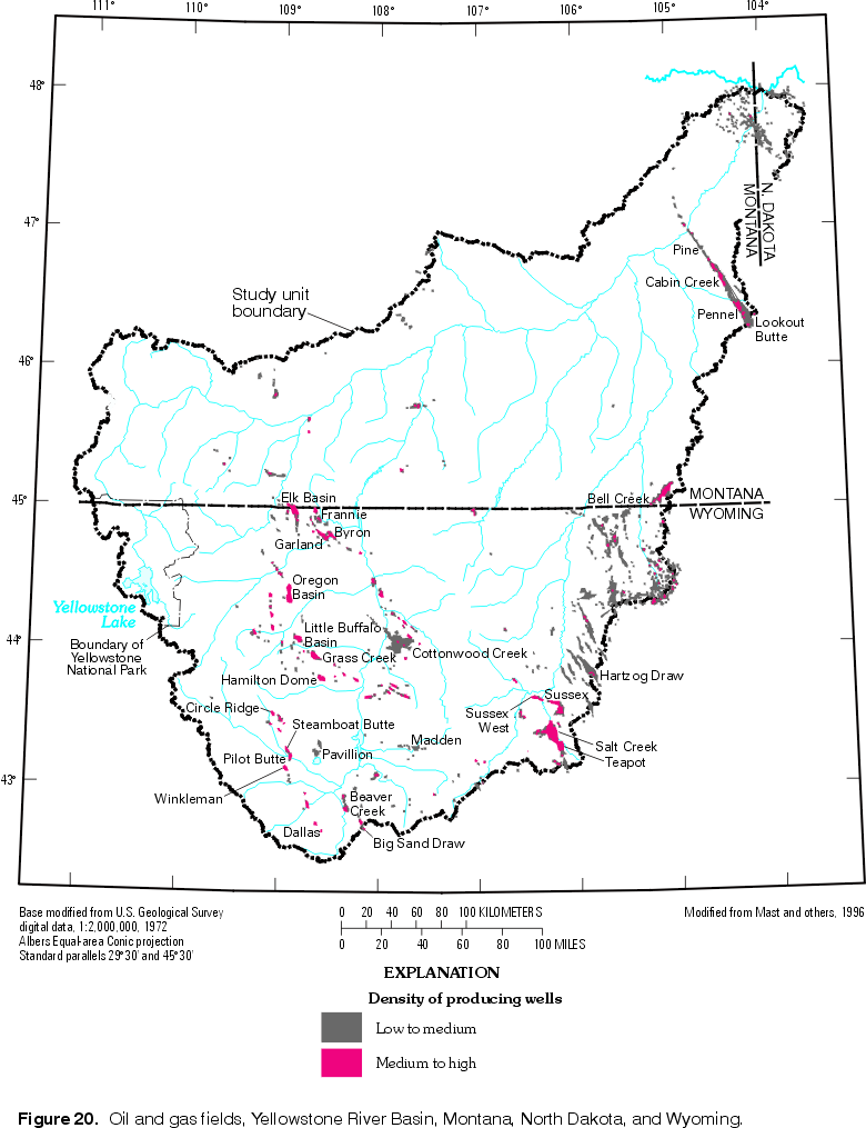 |
| Figure 20. Oil and gas fields, Yellowstone River Basin. (Click on image for a larger version, 85 kb) |
Hydrocarbon Production--Located within the study unit are three of the largest oil fields of the Rocky Mountain region--the Salt Creek field in the Powder River Basin, and the Elk and Oregon Basins in the
Bighorn Basin (fig. 20). Each field contained more than 500 million barrels of oil initially (Spencer, 1996). Two other YRB oil fields also rank among the top 120 nationally in annual production--Hartzog Draw in the Powder River Basin and Pennel in the Williston Basin (U.S. Department of Energy, Energy Information Administration, 1996). One of the Nation's largest natural gas fields lies within the study unit--the Madden field in the Wind River Basin. In addition to the well fields, two large oil refineries at Billings, Mont., and a third located 27 km west, process almost 50 million barrels of crude oil annually (Montana Oil and Gas Conservation Division, 1996).
The importance of oil fields for understanding water-quality conditions and aquatic biota lies in potential contamination by both hydrocarbons and associated brines. Large volumes of saline water typically are produced in conjunction with oil extraction and commonly are discharged to nearby streams. Also, evaporation pits located in oil fields sometimes contain a surface layer of floating oil, which has been blamed for the deaths of numerous migratory waterfowl each year (Marsden, 1997). Pipeline breaks and accidental discharges are other events that can cause water-quality impairment.
Commercial oil production began in 1884 with the Dallas oil field in the Wind River Basin, and in 1889 at what later became the Salt Creek field (DeBruin, 1993). From 1906 through 1928, about 10 major fields within the YRB were discovered on anticlines along the margins of the Bighorn, Powder River, and Wind River Basins. Recent production estimates for several of the largest oil fields within each of the four major structural basins in the study unit are listed in table 12.
Table 12. Principal oil fields in the Yellowstone River Basin (Data from Wyoming Oil and Gas Conservation Commission, 1997; and Montana Oil and Gas Conservation Division, 1996)
[Montana data are for 1995; Wyoming data are for 1996]
|
Structural basin |
Field |
Year discovered |
Annual oil production, 1995-96, in million barrels |
Cumulative oil production through 1995-96, in million barrels |
|---|---|---|---|---|
|
Bighorn |
Elk Basin |
1915 |
2.4 |
536 |
|
do. |
Oregon Basin |
1912 |
4.5 |
437 |
|
do. |
Hamilton Dome |
1918 |
1.8 |
248 |
|
do. |
Grass Creek |
1914 |
1.5 |
200 |
|
do. |
Garland |
1906 |
2.0 |
181 |
|
do. |
Little Buffalo Basin |
1914 |
.9 |
130 |
|
do. |
Byron |
1918 |
.7 |
126 |
|
do. |
Frannie |
1928 |
.3 |
116 |
|
do. |
Cottonwood |
1953 |
1.6 |
61 |
|
Powder River |
Salt Creek |
1889 |
2.4 |
653 |
|
do. |
Bell Creek |
1967 |
.1 |
132 |
|
do. |
Hartzog Draw |
1976 |
2.2 |
94 |
|
do. |
Sussex-Sussex West |
1948 |
.3 |
90 |
|
do. |
Teapot |
1922 |
.6 |
26 |
|
Williston |
Pine |
1952 |
.9 |
113 |
|
do. |
Cabin Creek |
1953 |
1.5 |
100 |
|
do. |
Pennel |
1955 |
2.3 |
91 |
|
do. |
Lookout Butte |
1961 |
1.0 |
29 |
|
Wind River |
Winkleman |
1917 |
.3 |
91 |
|
do. |
Steamboat Butte |
1943 |
.3 |
89 |
|
do. |
Big Sand Draw |
1918 |
.1 |
57 |
|
do. |
Beaver Creek |
1938 |
.3 |
57 |
|
do. |
Circle Ridge |
1923 |
.7 |
32 |
Hydrocarbon production in the Bighorn, Powder River, and Wind River Basins is predominantly from Cretaceous reservoirs and often is associated with structural features. About 90 billion m3 of natural gas has been produced from Rocky Mountain foreland structures in those three basins, with 97 percent of hydrocarbon production in the Bighorn Basin having come from reservoirs in foreland structures (Mullen and Barlow & Haun, 1993). In the Bighorn Basin, most hydrocarbon production has come from anticlines around the basin margins, predominantly in association with oil reservoirs (Broadhead and Robertson, 1993). In contrast, the most productive reservoirs in the Powder River Basin have substantial stratigraphic components (Mullen and Barlow & Haun, 1993). Gas production in the Wind River Basin is predominantly from structural traps on basin margins and from stratigraphic and structural/stratigraphic traps near the basin center, from gas reservoirs not substantially associated with oil (Broadhead and Robertson, 1993). Nearly half of the 34 billion m3 of structurally trapped gas produced in the Wind River Basin has come from the Beaver Creek field (fig. 20) near Riverton (Mullen and Barlow & Haun, 1993).
Foreland structures were primary targets for oil exploration through the 1950s, but early drilling in the Powder River Basin occurred near seeps that later were recognized as originating at stratigraphic traps (Mullen and Barlow & Haun, 1993). The large, shallow structural traps of the Bighorn Basin discovered prior to 1920 have produced more than half of its gas and three-fourths of the 2.2 billion barrels of oil produced through 1990 (Mullen and Barlow & Haun, 1993). In the Wind River Basin, many structural traps are related to basement block-fault adjustments and may have no surface expression (Mullen and Barlow & Haun, 1993).
The Frontier Formation of the Upper Cretaceous Series is the major hydrocarbon reservoir in the study unit. The nearshore marine sandstone of the Frontier Formation is particularly productive at the Salt Creek and Teapot fields north of Casper, Wyoming. From this 114 km2 area, about 375 million barrels of oil and 21 billion m3 of associated gas had been produced through 1990 using more than 2,000 wells (Doelger and others, 1993).
Contamination of streams or aquifers due to coal-bed methane development represents another hydrocarbon-related environmental concern (U.S. Geological Survey, Energy Resource Surveys Program, 1997). Partial pressure of the gas must be reduced to release it from the coal; this is achieved by removing water from the coal bed. The produced water is either discharged to the surface or injected underground. The salinity of the produced water is often greater than that of the receiving water body (U.S. Geological Survey, Energy Resource Surveys Program, 1997).
Coal Mining--In 1994, the United States produced 909 million megagrams and consumed 844 million megagrams of coal, with 88 percent used by electric utilities (U.S. Dept. of Energy, Energy Information Administration, 1995). About 30 percent (270 million megagrams) of the domestic coal production comes from beds in the Paleocene Fort Union Formation, which contains vast amounts of strippable coal (Flores, 1996), much of it located within the YRB. Production from the thick, sub-bituminous low-sulfur coal beds in the Powder River Basin is increasing rapidly in response to the demand for low-sulfur steam coal by electric utility consumers, primarily outside the YRB (U.S. Geological Survey, 1996b).
Coal was produced commercially in the YRB in the early 1880s near Red Lodge, Mont., in the 1890s in the Powder River Basin, and at several other locations by 1915-20 when early production peaked. Large-scale surface mining began in the 1920s from the Rosebud coal bed (fig. 21), but most of the YRB coal production prior to 1940 continued to be from under-ground mines (U.S. Department of Energy, Energy Information Administration, 1994). Another peak in coal production coincided with the war years of 1942-45, but most of the mines were closed prior to 1960 (Slagle and others, 1983; 1986). The present period of increased coal production began in 1962 with the opening of the Big Horn Mine (fig. 21) north of Sheridan, Wyo. (Slagle and others, 1983).
 |
| Figure 21. Coal types and major coal mine lease areas,
Yellowstone River Basin. (Click on image for a larger version, 94 kb) |
Since 1975 coal production from the study unit has increased dramatically, particularly in the Powder River Basin (U.S. Geological Survey, 1996b). The approximately ten-fold increase in production is due both to rising demand for fuel for electric power generation and to the unsuitability of coal from other regions for attaining environmental-quality goals. More than 25 percent of the Nation's present coal production is from 25 mines developing the Wyodak-Anderson, Anderson-Dietz, and Rosebud coal beds or zones in the Powder River Basin (Flores, 1996). Some individual mines in the Powder River Basin produce more coal than some of the major coal-producing States to the east (Milici, 1996). All of the active coal mines in the study unit are surface (strip) mines. Despite tremendous current production, most fields in this coal region remain in early stages of development because transportation networks and markets remain less than fully developed (Milici, 1996; U.S. Geological Survey, 1996b).
More than 10 large surface coal mines are active, or temporarily idled, in the YRB: six of these strip coal from the Wyodak-Anderson bed in the mining area near Gillette, Wyo. (fig. 21), and another four mine the Anderson-Dietz bed near or upstream of Tongue River Reservoir (Jones, 1990; Lowry and others, 1986; Slagle and others, 1983); four mines (fig. 21; not all active) developed in the Rosebud bed are located 40-50 km south of the Yellowstone River in Montana (Bergantino and others, 1980). The Wyodak-Anderson coal bed has an average thickness of 15-30 m with less than 15 m of overburden, and is the most important of several minable coal beds within the Tongue River Member of the Paleocene Fort Union Formation (Glass and Jones, 1991). The Anderson-Dietz coal bed is about 14 m thick north of Sheridan, Wyo. (Glass and Jones, 1991). The Rosebud coal bed is up to about 9 m thick with 6-15 m of overburden (U.S. Department of Energy, Energy Information Administration, 1994).
Although not yet extensively developed, a stratigraphically lower coal bed, the Knobloch, is about 23 m thick in a core area along the Tongue River valley about 50 km northeast from Tongue River Reservoir (Sholes and Daniel, 1992). At least one mine is actively strip-mining lignite beds about 45 km northeast of Glendive, Mont., but production is essentially negligible (U.S. Department of Energy, Energy Information Administration, 1994).
Surface mining may increase the potential for water-quality problems. Surface mining alters the configuration of the land surface and subsurface strata, and long-term detrimental effects may result if the area is not properly reclaimed. Mining operations, which include vegetation removal, excavation, and production of large volumes of unconsolidated spoil material, increase the potential for erosion and sedimentation. Channel filling by sedimentation can decrease the water-carrying capacity of the stream and may lead to increased flooding. The habitat of aquatic organisms may be altered substantially through burial and decreased dissolved-oxygen concentration of the water, owing to decreased depth and increased temperature. Dissolution of minerals contained in sediment derived from recently excavated overburden material may result in increased dissolved-solids and trace-element concentrations and decreased pH values.
Acid mine drainage from coal beds is virtually unknown in the Northern Great Plains and Rocky Mountain Provinces. Coal in these provinces has fewer sulfide minerals, and the semiarid climate results in less water to transport the acid, should it form. In addition, the natural alkalinity of water and soil in the Western United States generally neutralizes acid, should it form.
Erosion and sediment deposition, potential issues in any watershed affected by mining, generally are controlled at all active mine sites as required by State and Federal surface-mining regulations. Erosion is controlled by proper grading and revegetation of areas affected by mining, and sediment runoff is controlled through the use of settling ponds. However, channel scour can modify aquatic habitat downstream from settling ponds if the discharged water has suspended-
sediment concentrations that are substantially smaller than the natural, or premining concentrations (Britton and others, 1989).
The potential effects of mining on ground water have caused some concern. Regionally, however, there probably will be no measurable effect on the quantity of flow because flow is dominantly local, rather than regional, in the upper several hundred feet of the coal-bearing rocks. The possible effects on quality of water have not been fully assessed (Lowry and others, 1986), although results from geochemical modeling in the Powder River Basin indicate potential for improved postmining water quality (Martin and others, 1988).
"Ground-water levels may be affected by surface coal mining. Mines located above water-yielding zones have little, if any, effect on water levels. Ground-water levels can decline in and near surface-mined areas where excavation intersects a water-yielding zone. Water-level declines may cause a decrease or loss of production or flow in wells and springs. These effects generally will be temporary and occur only during and for a limited time after active mining. The areal extent of mining effects on water levels is largely dependent on the geologic and hydrologic setting of the mine and the duration of mine dewatering. Coal beds are characterized by fracture systems that provide limited paths for the movement of water. Consequently, each sand lens or fracture system not contiguous with another can be considered to be an individual and relatively isolated aquifer. Recharge available to this individual aquifer is limited to leakage through the surrounding confining layers; thus, the areal extent of water-level changes resulting from mining can be relatively local. In most instances, upon completion of mining, water levels will rise until premining equilibrium conditions are approximated" (Slagle and others, 1984, p. 22).
The quality of ground water in the vicinity of surface mines may be affected by the replacement of overburden material after the coal is removed. Replacement of overburden results in the exposure of fresh mineral surfaces and provides the opportunity for renewed chemical reactions. The actions of sulfate-reducing bacteria can decrease sulfate concentrations. Chemical analyses of spoil-derived water from the Powder River Basin (Rahn, 1975; Van Voast and others, 1978) have indicated that the median dissolved-solids concentration of water in spoils can be 160 to 173 percent of that in stock and domestic wells. Computer modeling designed to assess potential increases in dissolved solids in streams as a result of leaching of spoil materials (Woods, 1981) indicates that large increases in dissolved-solids concentration are local and dilution occurs downstream. Simulation of a hypothetical plan to simultaneously mine all Federally owned coal potentially available for mining in the Montana part of the Tongue River Basin resulted in a maximum increase of 4.7 percent in the average annual dissolved-solids concentration of the Tongue River at Miles City.
Cooperative and individual studies of effects of existing mines by the Montana Bureau of Mines and Geology and U.S. Geological Survey (1978) have shown that:
Ground-water inflow to mine pits generally has been small.
Mine effluents have not created serious water-quality problems.
Local water-level declines can be substantial during mining.
Water levels generally will recover toward premining positions after mining ceases.
Mine spoils generally transmit water as well as or better than the natural aquifers.
The problem of mineralization of water is small regionally.
Deeper aquifers are available to replace water supplies that are permanently lost.
"The largest impact on the hydrology probably will be caused by the increases in population and land use, rather than actual mining activities" (Lowry and others, 1986, p. 6).
An awareness of how water is used in the YRB is necessary to understand hydrologic conditions. In general, water use refers to a set of interactions between human activities and the hydrologic environment. Within the YRB, agriculture, mining, thermoelectric power generation, other industries, municipal and domestic supply are the chief purposes for which water is withdrawn, delivered, and consumed or returned.
Withdrawals are quantities of water removed from ground- or surface-water sources and are considered to be self supplied. Delivery is water withdrawn from a ground- or surface-water source by a municipal water supply and conveyed to customers. Consumptive use is water evaporated, transpired, combined into products or crops, or consumed by humans or livestock and not immediately available for reuse. Water that reaches a ground- or surface- water source after leaving the point of use is considered a return (Solley and others, 1993). Return flows commonly affect the temperature and suspended-solids, nutrient, and major-ion concentrations of the receiving water body.
About 98 percent of all water used in the study unit in 1990 was surface water (table 13). Most of this water--about 99 percent--was used for agricultural crop and livestock production. However, ground water is an important resource in the study unit. About 97 percent of the domestic supply and about 27 percent of the public supply is from ground water. About 61 percent of the ground-water use in 1990 was for agricultural purposes. Mining, power generation, and industry made up most of the remaining uses of surface and ground water in 1990 (fig. 22).
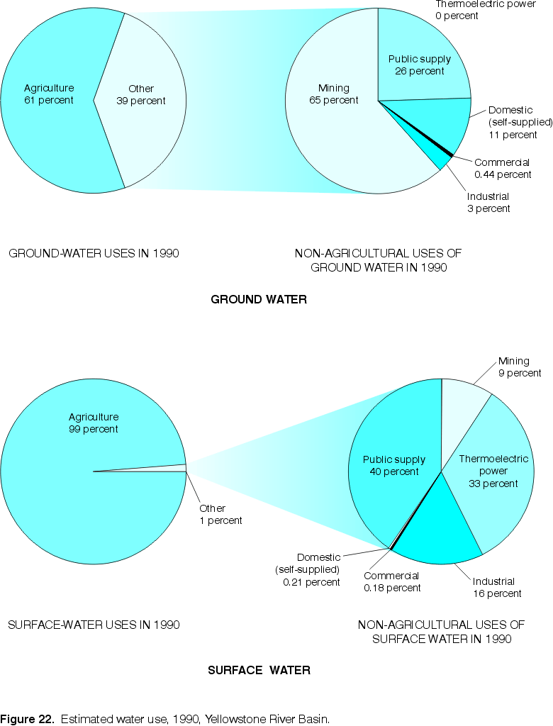 |
| Figure 22. Estimated water use, 1990, Yellowstone River
Basin. (Click on image for a larger version, 66 kb) |
Recreational uses, although important, are difficult to quantify. Many streams and lakes are heavily used for recreation, and the demand is increasing--affecting the water quality and aquatic organisms. The cold-water fisheries program stocked several million trout. Most of these were placed into high-quality cold-water streams.
There are no storage reservoirs on the mainstem of the Yellowstone River, though a proposal to build one at the narrows, just south of Livingston, was defeated in the 1970s (Chapple, 1997). However, hundreds of small impoundments for water supply, recreation, power, and flood control have been constructed within the study unit, in addition to several large dams on the major tributaries to the Yellowstone River. The six largest storage reservoirs in the study unit are listed in table 14.
Table 13. Reported surface- and ground-water use by category, 1990, Yellowstone River Basin
(Modified from Miller and Quinn, 1997) [m3/d, cubic meters per day; Mgal/d, million gallons per day]
|
|
Surface-water use |
Ground-water use |
||
|---|---|---|---|---|
|
Category |
m3/d |
Mgal/d |
m3/d |
Mgal/d |
|
Public supply |
150,000 |
40 |
57,000 |
15 |
|
Domestic |
800 |
.21 |
24,000 |
6.3 |
|
Commercial |
680 |
.18 |
950 |
.25 |
|
Industrial |
61,000 |
16 |
5,700 |
1.5 |
|
Thermoelectric power |
120,000 |
33 |
0 |
0 |
|
Mining |
34,000 |
9.0 |
140,000 |
37 |
|
Agriculture |
26,000,000 |
6,900 |
350,000 |
93 |
|
aTotal |
26,000,000 |
7,000 |
570,000 |
150 |
aValues expressed using two significant figures.
Reservoirs often have a dramatic effect on water quality and resident biota. The typically nutrient-rich, stilled water allows aquatic vegetation to flourish, which can greatly diminish dissolved-oxygen concentrations through respiration and decomposition (Cole, 1983). Reservoir construction causes a loss of riparian habitat through inundation, and alters the aquatic and riparian habitats downstream (Knight, 1994). Reservoirs can be very effective sediment traps; flowing water loses its transport capacity as it enters a calm water body and deposits its sediment load. In addition, reservoir water levels typically fluctuate considerably--high in the late spring to store snowmelt runoff for flood control and for the onset of the agricultural irrigation season, but low by the end of the growing season. Fluctuating water levels create nearly barren shores around such reservoirs when the water level is low, because most riparian plants cannot tolerate the drastic fluctuations of water levels (Knight, 1994).
Waste materials deposited into water, land, air, and underground disposal sites can become a source of surface- and ground-water contamination. Although substantial improvements have been made in recent years in their disposal, wastes have not always been properly handled. Hundreds of active or abandoned waste sites exist in the YRB, including two sites from the USEPA's Comprehensive Environmental Response, Compensation, and Liability Act (CERCLA) National Priorities List.
The USEPA's Toxics Release Inventory (TRI) is a publicly available database containing specific toxic-chemical release and transfer information from industrial facilities (table 15). Facilities that have the equivalent of 10 or more full-time employees and meet the established thresholds for manufacturing, processing, or otherwise using listed chemicals must report their releases and transfers. The TRI does not account for toxic emissions from automobiles and many other non-industrial sources.
Sewage and industrial wastes can cause problems associated with bacteria, nutrients, dissolved oxygen, suspended solids, organic compounds, and trace elements in streams. Many bacteria are pathogens. Nutrients, such as nitrogen and phosphorus, can stimulate growth of aquatic plants and contribute to algal blooms. An algal bloom is the rapid growth of one or more species of suspended (phytoplankton) or attached (periphyton) algae that leads to an accumulation of algal biomass. As the algae die, decomposition can consume more oxygen than the living algae produce; hence, the dissolved-oxygen concentration of the water can decrease below the level needed for fish to survive. Suspended solids decrease light penetration, can be harmful to fish in large concentrations, and, if deposited, decrease the water-carrying capacity of the stream and may lead to increased flooding. Organic compounds and trace elements are ubiquitous contaminants having the potential to bioaccumulate in living organisms.
The Federal Water Pollution Control Act of 1972 (commonly known as the Clean Water Act) requires wastewater dischargers to have a permit establishing pollution limits, and specifying monitoring and reporting requirements. National Pollutant Discharge Elimination System (NPDES) permits regulate household and industrial wastes that are collected in sewers and treated at municipal wastewater treatment plants. Permits also regulate industrial point sources and concentrated animal feeding operations that discharge into other wastewater collection systems, or that discharge directly into receiving water bodies. More than 200,000 sources are regulated by NPDES permits nationwide.
Table 14. Names and descriptions of major reservoirs in the Yellowstone River Basin
(Data from Brosz and Hasfurther, 1990; Harza Engineering and others, 1983; Shields and others, 1997)
[km, kilometer; km
3
, cubic kilometer]
|
Reservoir name |
Year completed |
Storage capacity, |
|---|---|---|
|
Bull Lakea |
1938 |
.189 (153,000) |
|
Boysen Reservoir |
1951 |
.989 (802,000) |
|
Buffalo Bill Reservoirb |
c1909 |
.857 (695,300) |
|
Bighorn Lake |
1967 |
1.695 (1,375,000) |
|
Tongue River Reservoir |
1939 |
.084 (68,040) |
|
Lake De Smetd |
e1921 |
.290 (235,000) |
aNot
shown in fig. 1; located 58 km west-northwest of Riverton, Wyo.
bNot
shown in fig. 1; located 11 km west of Cody, Wyo.
cDam
height increased by 7.6 meters, effective 1992; previous storage capacity was
0.746 km3 (424,000 acre-feet)
dNot
shown in fig. 1; located 39 km south-southeast of Sheridan, Wyo.
eDams
enlarging the storage capacity of this natural lake were completed in 1921,
1971, and 1978.
Table 15. Toxic Release Inventory emissions in the Yellowstone River Basin, 1993
(Data from U.S. Environmental Protection Agency, 1995)
[All values in thousands of kilograms]
|
Industry type |
Water |
Land |
Air |
Under-ground |
Total |
|---|---|---|---|---|---|
|
Petroleum refineries |
51 |
0.8 |
266 |
0 |
317 |
|
Chemical manufacturing |
0 |
0 |
20 |
0 |
20 |
|
Mining and extraction |
0 |
0 |
0.2 |
0 |
0.2 |
|
Other manufacturing |
27 |
12.6 |
245 |
0 |
285 |
|
Totala |
78 |
13.4 |
531 |
0 |
622 |
aValues expressed using three significant figures.
One-hundred thirty-two NPDES permitted facilities were listed in the YRB in 1997. Of these, 26 facilities are identified as major dischargers (12 municipalities, 4 beet-sugar manufacturers, 4 mines, 3 petroleum refineries, 2 electric power-generating plants, and 1 railroad yard).
The USEPA's TRI database listed about 78,000 kg of toxic releases to water in 1993 from manufacturing facilities in the YRB. About 65 percent of this total is attributable to petroleum refineries, with the remainder resulting from other manufacturing operations.
Wastes are disposed on land within the YRB by several methods including septic systems, landfills,
surface impoundments, and land application of treated substances. These methods generally have a more immediate potential to contaminate shallow ground-water resources than to affect stream water.
Septic systems contribute filtered sewage effluent directly into the ground. The septic effluent contains bacteria, nutrients, organic carbon, chlorides, and contaminants from household wastes. Septic systems are designed to use the soil to filter bacteria and attenuate as many of the other constituents as possible. However, where soil is thin, or where permeable rocks underlie the septic system, ground-water contamination is likely. A cesspool pit can pose a serious contamination threat to the nearby well-water supply (Risser and Siwiec, 1996). As ranch land is converted to rural residential use there is a greater risk of contamination of the water supply.
The USEPA's TRI database listed about 13,400 kg of toxic releases to land in 1993 from industrial facilities in the YRB. It is estimated that 90 percent of the industrial wastes that are considered to be hazardous are landfilled, primarily because it is the least expensive waste management option (Freeze and Cherry, 1979). The USEPA's Office of Solid Waste listed 41 active municipal solid-waste landfills in the YRB in 1995 (U.S. Environmental Protection Agency, 1996b). At a landfill, solid waste is reduced in volume by compaction and then is covered with earth. In North America a large number of the older sites that receive municipal wastes are open dumps or poorly operated landfills. Newer sites are generally better situated and better operated. Nevertheless, contamination of surface and ground water from landfills is possible from storm runoff and infiltration of leachate. Not only do the leachates contain contaminants derived from the solids, but many leachates contain toxic constituents from liquid industrial wastes placed in the landfill.
Surface impoundments are used primarily to store wastes. Surface- and ground-water contamination can result if the impoundment leaks. Nutrient contamination--nitrates in particular--of ground water is a concern arising from the storage of animal manure.
Land application is widely used to dispose of stabilized municipal sewage sludge, septic-tank wastes, sludge from drinking-water treatment plants, and composted leaves. Treated wastes are commonly applied directly to the land surface in the study unit. This disposal method employs natural properties of soil and biota to remove bacteria and excess nutrients in the waste (Metcalf and Eddy, Inc., 1972). Care, however, must be exercised to assure that the ability of the soil to assimilate wastes is not overloaded; otherwise, ground-water contamination will result.
In the Western United States, available data indicate that precipitation at individual sites has been acidified by anthropogenic emissions. The acidification generally has been attributable to localized sources and the time of initial acidification is undefined (Turk, 1983).
The USEPA's TRI database listed 531,250 kg of toxic releases to the air from industrial facilities in the YRB in 1993. About 50 percent of this total is attributable to petroleum refineries and another 46 percent resulted from other manufacturing operations. These amounts do not include small generators and non-point sources such as automobiles and agricultural-chemical applicators. Total emissions would likely be much greater if these other sources were included.
Precipitation cleans the atmosphere of airborne toxic vapors and particles and deposits them onto the earth's surface, including lakes, rivers, and streams. In addition, dry atmospheric deposition in the form of vapors and particulate matter also returns airborne compounds to the earth's surface. Toxic compounds in both precipitation and dry deposition reach surface water as direct deposition and in surface runoff, and can reach ground water by infiltration through the soil (Majewski, 1995).
Injection of liquid wastes, mainly of industrial origin, has been widely adopted as a waste disposal practice in North America (Freeze and Cherry, 1979). The purpose of this procedure is to isolate hazardous substances from the biosphere. As the discharge of pollutants to rivers and lakes has become increasingly objectionable, and as legislation for protection of surface water resources has become more stringent, the use of deep permeable zones for liquid waste disposal has become an increasingly attractive waste management option for many industries. Chemical, petrochemical, and pharmaceutical companies are the largest users of waste-injection wells. Other important users are petroleum refineries, gas plants, steel mills, potash mines, uranium mills, and processing plants (Freeze and Cherry, 1979). Large septic systems used for disposal of sanitary waste in establishments serving more than 20 people per day, or any septic system used for industrial wastewater, qualify as "underground injection wells" regulated by USEPA's Underground Injection Control program. The Wyoming Department of Environmental Quality lists several hundred sites of underground injection in the YRB (Bob Lucht, Wyoming Department of Environmental Quality, oral commun., 1998).
Return to Environmental Setting of the Yellowstone River Basin, WRIR 98-4269