 |
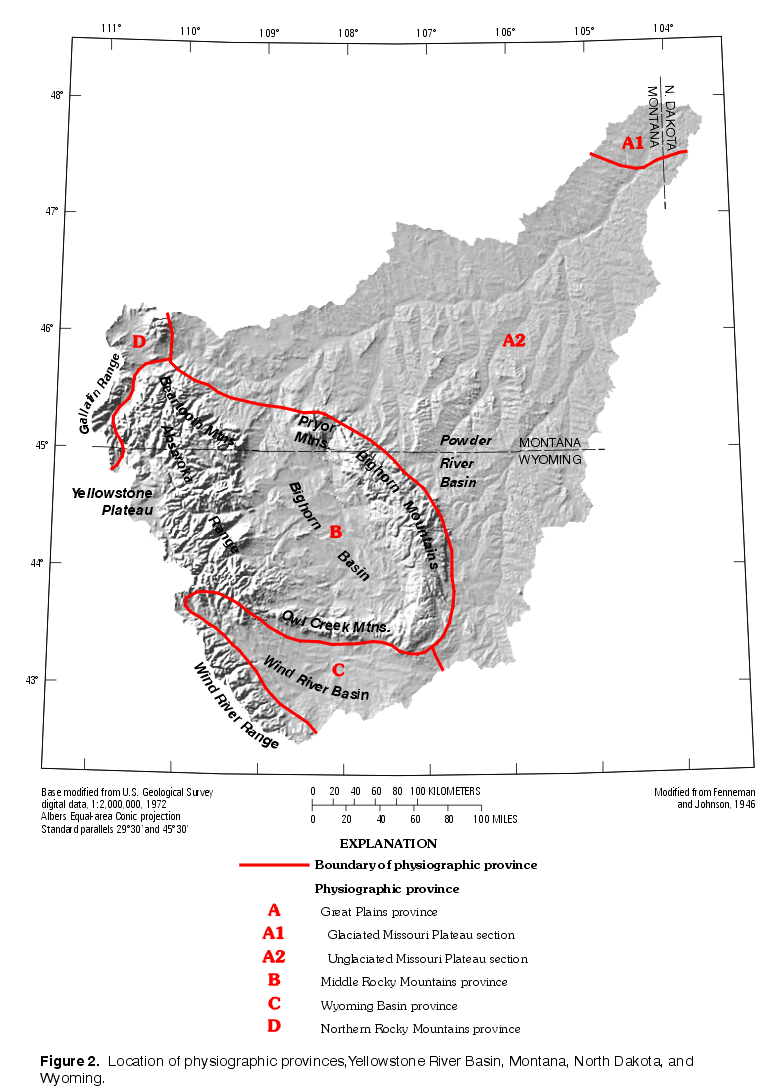
| Figure 2. Shaded relief map showing physiographic
provinces, Yellowstone River Basin. (Click on map for a larger version, 236 kb) |
The physical, chemical, hydrological, and ecological characteristics of an area are considered to compose its environmental setting (Stark and others, 1996). In a study unit as large and diverse as the YRB, strong contrasts among these characteristics exist. The water-quality characteristics of the study unit are expected to similarly be diverse and to reflect the environmental contrasts among the areas of water sources and those areas through which the water moves before exiting the YRB. This description of the environmental setting is not exhaustive, but concentrates on the factors believed to influence water quality and aquatic ecology in this study unit.
Both natural and anthropogenic factors affecting water quality are described. Natural factors discussed in this report are those which generally control water-quality characteristics in the absence of human activity. Although water and land use practices sometimes overshadow natural factors, understanding the natural diversity of the YRB is believed to be important in understanding its water-quality conditions. Natural factors include physiography, climate, geology, vegetation, and hydrology. Anthropogenic factors, including population, land cover and land use, water use, and waste disposal, are described following the natural factors.
Physiography refers to the physical morphology of the earth's surface. The study unit lies in parts of the Great Plains, Middle Rocky Mountains, Wyoming Basin, and Northern Rocky Mountains physiographic provinces (fig. 2) (Fenneman and Johnson, 1946). A digital map (G.P. Thelin, U.S. Geological Survey, unpub. data, 1992) of Fenneman's physical divisions at a nominal scale of 1:7,500,000 was used to summarize the distribution of physiographic provinces in the YRB. Digital elevation models (U.S. Geological Survey, 1987) for all 1- by 1-degree quadrangles of latitude and longitude in the study unit were assembled and used to summarize elevation. Elevation ranges from 564 m above sea level at the mouth of the Yellowstone River to about 4,200 m on the crest of the Wind River Range.
|
| Figure 2. Shaded relief map showing physiographic
provinces, Yellowstone River Basin. (Click on map for a larger version, 236 kb) |
Fifty-five percent of the study unit lies in the Great Plains Province (fig. 2). The Great Plains feature gently rolling topography in general, but some areas of sharply dissected badlands have developed in easily erodible shales. Most of this area is part of the unglaciated Missouri Plateau section of the Great Plains, but the extreme northeastern end of the YRB lies within the area subjected to continental glaciation. The unglaciated Missouri Plateau section displays the greatest variety of landforms in the Great Plains (Trimble, 1980). The topography of the unglaciated plains largely reflects fluvial dissection of the ancient outwash plain that extended eastward from the Rocky Mountains (Trimble, 1980). The sediments of this surface slope to the east at an average gradient of about 1.9 m/km (Howard and Williams, 1972). In places, the plateau is surmounted by higher erosional remnants of an older depositional surface (Trimble, 1980). Most rivers of this section flow in broad alluvial valleys established prior to the advance of continental ice sheets (Trimble, 1980). Elevations in the Great Plains Province range from 570 to 2,200 m within the study unit, averaging 1,070 m. Local relief typically is less than 150 m, but in parts of the Powder River Basin increases to about 300 m.
The Middle Rocky Mountains Province (fig. 2) contains 35 percent of the study unit and features landforms varying from mountain ranges and high plateaus to intermontane basins, such as the Bighorn Basin. Elevations in this province range from 1,040 to about 4,200 m within the study unit, averaging 2,090 m. Centered in this part of the study unit is the Bighorn Basin, bordered on the west by the Absaroka Range and Beartooth Mountains, on the south by the Owl Creek Mountains, and on the east and northeast by the Bighorn and Pryor Mountains. To the north, the basin is topographically open where it merges into the Crazy Mountains Basin (or Syncline) of south-central Montana (Lageson and Spearing, 1988), not shown in figure 5.
Most of the mountain ranges have a high axial crest surmounting a broad, high-elevation erosional surface that slopes gently outward until dropping off abruptly to the lowlands. Remnants of this surface are found on gravel-capped mesas in the adjacent basins. Lower erosional levels are evidenced by lower mesas and by broad, paired alluvial terraces (Howard and Williams, 1972, p. 29).Badlands topography has developed in parts of the Bighorn Basin where the Willwood Formation of Tertiary age crops out (Mears and Marston, 1990). Local relief is 150 to 300 m in this basin, which is topographically classified as plains with high hills (Mears and Marston, 1990).
The Bighorn and Wind River mountain ranges are broad anticlines flanked by hogbacks. The Beartooth Mountains are high plateaus atop several uplifted blocks that are dissected by numerous glaciated river valleys (Page and Zientek, 1985). The Absaroka Range consists of thick volcanic deposits presenting a rugged topography dominated by deep, steep-sided valleys with erodible slopes and large areas of cliffs and talus (Despain, 1990). All of these mountain ranges feature local relief typically in excess of 1,000 m.The volcanic Yellowstone Plateau lies west of the Absaroka Range and features an undulating, almost level surface averaging about 2,500 m in elevation. Both the Yellowstone Plateau and the Absarokas are topographically classified as tablelands with high relief, being 50 to 80 percent gently sloping terrain, with 50 to 75 percent of that occurring in uplands (Mears and Marston, 1990).
A few broad valleys with large meandering rivers are located within the Middle Rockies, but stream gradients within the mountainous areas generally are steep. Dense vegetation and armored streambeds resist erosion, but where soft rocks are exposed or vegetation is disturbed, rapid erosion occurs (Missouri Basin Inter-Agency Committee, 1969). The drainage network of the Middle Rocky Mountains Province features several deep canyons, such as the Bighorn and Wind River Canyons, where rivers cut through mountain ranges rather than following lowland courses around the barriers. These canyons are attributed to superimposition of stream courses from the surface of sediments that formerly filled the basins to higher levels than at present (Howard and Williams, 1972).
The part of the Wyoming Basin physiographic province contained within the study unit, composing about 7 percent of the study unit, corresponds to the Wind River Basin. The boundary between this province and the Great Plains is the subtle surface expression of the Casper Arch (fig. 5); this gap south of the Bighorn Range is the only area where the mountainous western border of the Great Plains is interrupted. The Wind River Basin is bounded on the north by the Owl Creek Mountains, on the west by the Wind River Range (fig. 2), and on the south by minor ranges associated with the Sweetwater uplift (fig. 5). Terrace and pediment surfaces form extensive tablelands, and locally prominent badlands are eroded into soft Tertiary sediments (Keefer, 1965). Elevation in this province ranges from 1,440 to 3,600 m within the study unit, averaging about 1,840 m. Local relief is typically 150 to 300 m.The Northern Rocky Mountains Province (fig. 2) contains about 3
percent of the study unit. This province is separated from the Middle Rocky
Mountains Province only by the Yellowstone River valley and
Yellowstone Plateau. Elevation in this province ranges from 1,310 to 3,350 m
within the study unit, averaging about 1,930 m.
 |
| Figure 3. Hypsometric curve for Yellowstone River Basin. (Click on image for a larger version, 19 kb) |
Climate in the study unit ranges from cold and moist in the mountainous areas to temperate and semiarid in the plains areas. Primarily because of its midcontinental location, the basin's weather is characterized by fluctuations and extremes (Missouri Basin Inter-Agency Committee, 1969). The interaction between air masses originating in the Gulf of Mexico, the northern Pacific Ocean, and the Arctic regions is largely responsible for the seasonal climate regimens found within the study area. The Gulf air tends to dominate in spring and early summer, but Arctic air dominates in winter (Missouri Basin Inter-Agency Committee, 1969).
Mean annual temperatures range from less than 0°C at Yellowstone Lake to about 10°C along the Bighorn River valley in Montana (National Climatic Data Center, digital data, 1994). Annual temperature extremes range from about -40°C during the winter to hotter than 38°C during the summer (Western Regional Climate Center, digital data, 1997). Temperatures generally are coldest in January, when average daily lows range from less than -18°C in higher elevations to about -8°C near Livingston, Mont. (Western Regional Climate Center, digital data, 1997), and average monthly temperature ranges from less than -13°C (fig. 4, part 1 and part 2) in Yellowstone National Park to about -3°C near Livingston, Mont. (National Climatic Data Center, digital data, 1994). July normally is the warmest month, with average daily highs ranging from about 22°C in higher elevations to about 32°C in some valleys of the Great Plains and Wyoming Basin Provinces (Western Regional Climate Center, digital data, 1997). Average July temperature ranges from about 12°C in higher elevations to about 24°C in some valley locations (National Climatic Data Center, digital data, 1994). The average frost-free period ranges from less than 10 days at high elevations (Marston and Anderson, 1991) to more than 140 days on the plains and in lower basins (U.S. Department of the Interior, 1965). The climate is cold enough at some sites to form permanent ice (permafrost) in the ground: local permafrost occurs at elevations as low as 2,400 to 2,600 m on north slopes near Yellowstone National Park (Pierce, 1979). |
 |
| Figure 4. Average annual precipitation, Yellowstone River Basin. (Click on image for a larger version, 228 kb) | Figure 4--continued. Graphs showing mean daily precipitation and temperature at selected stations. (Click on image for a larger version, 62 kb) |
In the YRB, 40 to 45 percent of the annual precipitation falls during April through June at most locations (fig. 4, part 1 and part 2), but this seasonality diminishes in mountainous areas. Mean annual precipitation ranges from about 150 mm (5.9 in.) in the central parts of the Bighorn and Wind River Basins to more than 1,500 mm (59 in.) at high elevations in the mountains near Yellowstone National Park (Oregon Climate Service, 1995a, 1995b). Snowfall composes a substantial part of annual precipitation in most years, with average annual snowfall ranging from less than 300 mm (12 in.) in parts of the Bighorn Basin to more than 5,200 mm (200 in.) near Yellowstone National Park (Western Regional Climate Center, digital data, 1997). The mountain ranges in the study unit cause precipitation to vary strongly with elevation, because in mountainous terrain, most of the spatial variation in precipitation is explained by orographic effects of the large-scale terrain features (Daly and others, 1994). Annual precipitation in the plains areas generally is more variable from year to year, and less than in the mountains (Slagle and others, 1983).
Evaporation varies with temperature, which, in turn, is strongly affected by elevation (Reider, 1990). Evaporation in the YRB is affected more by prevailing wind and sky conditions than by latitude, as shown by published maps of mean annual evaporation for 1956-70 (Farnsworth and others, 1982). Evaporation is greatest in the windswept basins and prairies where the mean annual total generally exceeds 900 mm (35 in.), and surpasses 1,100 mm (43 in.) in parts of the Bighorn and Powder River Basins and Yellowstone River valley. In the cool, often cloud-shrouded highlands of the Absaroka and Beartooth Mountains, mean annual evaporation is less than 500 mm (Martner, 1986). Evaporation and precipitation together distinguish the moist, mountain forest ecosystem from the lower-elevation regions where evaporation exceeds precipitation (Ostresh and others, 1990; Marston and Anderson, 1991).
Return to Environmental Setting of the Yellowstone River Basin, WRIR 98-4269