 |
| Figure 5.Generalized depth to Precambrian basement
structure, Yellowstone River Basin. (Click on image for a larger version, 132 kb) |
The YRB contains parts of three geologic provinces: the uplifts and basins of the Rocky Mountain foreland, the Yellowstone Plateau, and the Absaroka volcanic field (Snoke, 1993). The structural framework of uplifts and sedimentary basins is shown in figure 5. This section of the report presents a brief overview of the principal structural features of the study unit.
|
| Figure 5.Generalized depth to Precambrian basement
structure, Yellowstone River Basin. (Click on image for a larger version, 132 kb) |
The Absaroka volcanic field and the Yellowstone Plateau are the two major post-Laramide (Late Cretaceous through Paleocene) volcanic fields in the YRB. The Beartooth, Bighorn, Owl Creek, and Wind River Mountain ranges are the major uplifted areas. The basement-cored uplifts commonly feature complex structures, including foliation, small-scale folds, shear zones, and igneous dikes (Brown, 1993).
The Absaroka volcanic field of Tertiary age is the largest, least-studied volcanic province in the conterminous western United States (Snoke, 1993). This massive volcanic field covers about 23,000 km2 to a maximum thickness of about 1,500 m (Smedes and Prostka, 1972), and extends well beyond the Absaroka Range itself, so that some workers name it the Absaroka-Gallatin volcanic province (Chadwick, 1970). The volcanic rocks are mostly composed of andesite and dacite; units are chiefly flows, breccias, and stocks. Eruptive centers are aligned along two subparallel northwest-trending structural zones (Chadwick, 1970), one of which includes the Emigrant-Mill Creek, Independence, New World, and Sunlight mineral districts (fig. 9) (Elliott and others, 1983; 1993). An overall pattern of progressively younger eruptive centers transgressing from northwest to southeast has been suggested (Snoke, 1993). The vent areas for the volcanics were predominantly calc-alkaline stratovolcanoes and shield volcanoes composed of lava flows, flow breccias, mudflows, avalanche debris, and tuff in a chaotic assemblage called vent facies (Smedes and Prostka, 1972). Outward from the volcanic centers, the vent facies rocks interfinger with, and grade into, reworked volcanic sedimentary rocks--mainly volcanic conglomerate, breccia, volcanic sandstone and siltstone, and air-fall tuff that together are called alluvial facies (Smedes and Prostka, 1972). The volcanic field may have originally covered much of the Bighorn Basin (Love, 1939; Smedes and Prostka, 1972), and extends into the south-central part of the Beartooth uplift (Montagne, 1982, p. 12). However, there is no evidence to indicate what was the northernmost extent of this volcanic field (Smedes and Prostka, 1972).
The Yellowstone Plateau is the product of volcanic eruptions of Quaternary age. Each of three cycles of volcanic activity climaxed with an explosive eruption that produced a voluminous rhyolitic ash flow and a large collapse caldera (Christiansen and Blank, 1972). Rhyolites predominate among the volcanic rocks of the plateau, but basalts also occur. The enormous caldera, 70 by 45 km across and formed in the third volcanic cycle, has been partly filled by rhyolitic lava flows, and is surrounded by a ring of predominantly rhyolitic welded tuff (Christiansen and Blank, 1972). The ash flows cover several hundred km2, and eolian ash deposits are widespread throughout the western U.S. (Snoke, 1993). With the volume of expelled Quaternary volcanic material totalling about 8,000 km3, Yellowstone may be the world's largest center of active silicic volcanism (Smith and Braile, 1993). At the present time, the extremely high flow of heat from the Yellowstone Plateau (Smith and Braile, 1993) is evidence that magmas, partial melts, and extensive hydrothermal systems lie beneath the caldera.
A third volcanic area, the Sliderock Mountain (fig. 5) area, lies north of the Beartooth uplift and is underlain by mainly intrusive, volcanic, and volcaniclastic rocks that correlate with deposits of the Livingston Group that lie to the north and northwest (Elliott and others, 1993). The Livingston Group is a thick sequence of volcanic sedimentary rocks that was derived principally from a volcanic field to the northwest (Roberts, 1963) that lies well outside the YRB. However, within the Sliderock Mountain area the geology is dominated by the remains of a deeply eroded Upper Cretaceous stratovolcano composed of lahar deposits and andesite lava flows (Elliott and others, 1993).
The Beartooth uplift, a broad fault-bounded Laramide uplift, includes all of the Beartooth Mountains and merges with the northern Absaroka Range along the south-central part of the uplift (Elliott and others, 1993). The Beartooth uplift is bounded on the east by the Bighorn Basin, on the west by the alluvium-filled valley of the Yellowstone River, and on the south by the Clarks Fork Yellowstone River (Elliott and others, 1983). The Beartooth uplift contains a core of Precambrian crystalline rocks--gneiss, granitics, and supracrustal rocks (Page and Zientek, 1985)--flanked by Paleozoic and younger rocks, and is bounded by thrust faults (Casella and others, 1982). An upper plate of metasedimentary and plutonic rocks was displaced about 15 km toward the north-northeast along a low-angle thrust fault dipping approximately 30° to the southwest (Brown, 1993; Page and Zientek, 1985). Along the southwest marginal thrust fault, Precambrian rocks crop out from beneath the Absaroka volcanic field and Paleozoic sedimentary rocks; the western section of the uplift features metasedimentary rocks intruded by granitics; and the eastern two-thirds of the uplift contains mainly gneisses (Casella and others, 1982; Mueller and others, 1985).
Along the northern edge of the Beartooth Mountains, the Stillwater Complex (fig. 5) of Precambrian age, a mafic to ultramafic, layered igneous intrusion containing mineralized areas, crops out over an area about 50 km long and up to 8 km wide (Page, 1977). The parent magma of the complex was intruded as a horizontal sill into sedimentary rocks that were metamorphosed to hornfels. After crystallizing, the complex was tilted, beveled by erosion, later deformed during the Laramide orogeny, and today stands nearly vertical (Simons and others, 1979). As a result of the tilting, a 5,500-m thick section of layered igneous rocks is exposed (Elliott and others, 1993, p. 9).
The Bighorn Mountains (fig. 5) represent a major structural arch whose crystalline core is bounded and transected by faults. The northern part of the structural arch plunges northwesterly at a low angle (Van Gosen and others, 1996). The Bighorn Mountains are bounded on the north by a narrow, northwest-trending zone composed of a series of northeast-trending, normal faults (Blackstone, 1975). Along their eastern margin, the Bighorns have been displaced eastward along low-angle thrust faults (Brown, 1993). The northern part of the Bighorn Mountains lies on the upthrown side of an east-west trending thrust fault, and the southern part lies on the upthrown side of a high-angle fault trending northeast-southwest (Blackstone, 1993). The crystalline rocks remain buried beneath Paleozoic sedimentary rocks throughout much of the northern Bighorn uplift, including the Pryor Mountains.
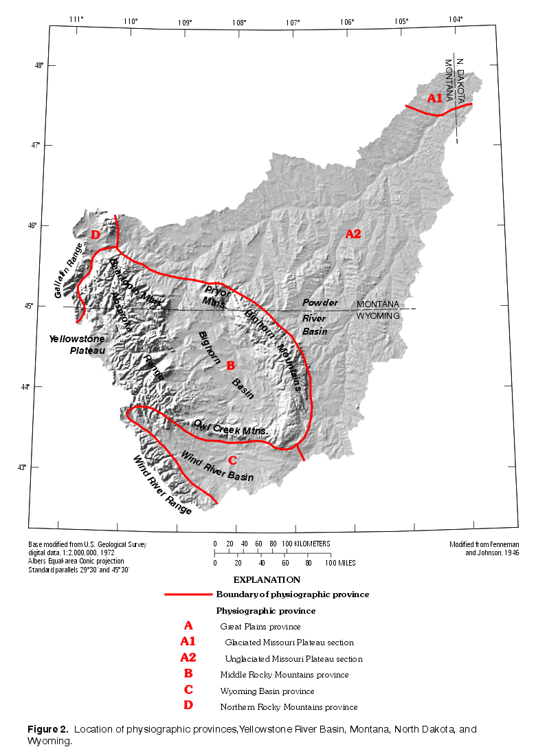
Although they are topographically distinct from the Bighorn Mountains, the Pryor Mountains (fig. 2) are the northwest extension of the Bighorn structural uplift (Blackstone, 1975). Five tilted fault blocks compose the Pryor Mountains, with each block being uplifted highest at its northeast corner (Blackstone, 1975). Block boundaries include faults and faulted or unfaulted folds (Van Gosen and others, 1996).
The Owl Creek Mountains (fig. 2) are a narrow, east-west trending, asymmetrical anticline. The north flank of the uplift is overlain by northward-dipping Paleozoic sedimentary rocks, and the southern flank is overlain by Tertiary strata. Concealed by the Tertiary deposits are Paleozoic and Mesozoic rocks that are overthrust by Precambrian crystalline rocks that form the core of the uplift (Hausel, 1989).
The Wind River Range (fig. 5) is an asymmetrical anticline having a Precambrian core of high-grade metamorphic and igneous rock. Along its eastern flank, Paleozoic and Mesozoic strata dip eastward, but along the northern and northeastern flanks the strata are folded and faulted. Major, moderately dipping faults bound the range on the south and west and overthrust the Precambrian igneous and metamorphic rocks above basin-filling sedimentary strata. The crystalline core of the range is a complex of migmatite, felsic orthogneiss, and paragneiss intruded by quartz diorite to granite plutons (Hausel, 1989). The southern margin of the early crystalline complex is intruded by a granodiorite batholith that also intrudes the gneiss complex adjacent to the South Pass greenstone belt (Hausel, 1991).
The names of several structural basins are identical with names of surface drainage basins. In most cases the geographic extent of both same-named basins is roughly equivalent. However, the reader is alerted to a substantial difference in the geographic extent of the hydrologic Powder River Basin (entirely within the study unit) and the structural basin of that same name (extending well beyond the study unit on its southeastern margin).
The Bighorn Basin is asymmetric, with its western flank being the steepest and its axis trending northwest-southeast; sedimentary rocks of the structural basin exceed a maximum thickness of 7,200 m along the basin axis southeast of Cody (Blackstone, 1993). On the east, the Bighorn Mountains are thrust westward onto basin sedimentary rocks at the northern and southern ends of the mountain range (Lageson and Spearing, 1988). Major deformation produced a zone of folded rocks around the flanks of the basin (Blackstone, 1988); some of these structural features are important reservoirs of oil and gas.
The Crazy Mountains Basin (or Syncline) (fig. 5) is a northwesterly trending structural basin filled with sedimentary, intrusive, volcanic, and volcaniclastic rocks (Elliott and others, 1993). Subsidence and deposition were greater in the western part of the basin (Roberts, 1963). The deposits attain a maximum thickness of about 9,000 m.
The Powder River Basin (fig. 5) is a gentle syncline between the Bighorn Mountains on the west and the Black Hills of South Dakota on the east (not shown on fig. 5) (Berryhill and others, 1950). The Miles City Arch separates the Powder River and Williston structural basins (fig. 5). The southern and southeast parts of the structural basin lie outside the study unit. The Powder River basin's axis trends northwest-southeast and lies near its more steeply dipping western flank along the Bighorn Mountains and the Casper Arch (Blackstone, 1993). The maximum thickness of sedimentary rocks in the Powder River Basin exceeds 5,400 m along the basin axis northeast of Casper.
The Williston Basin (fig. 5) is approximately oval shaped with the axis oriented north-northwest to south-southeast. The deepest part of the structural basin is in northwestern North Dakota, about 50 km east of the study unit. The maximum thickness of sedi-mentary rocks is about 5,200 m (Busby and others, 1995). The dip of the sedimentary strata varies, but is typically about 0.3 percent (Crosby and Klausing, 1984). The Cedar Creek anticline protrudes into the southwestern part of the Williston Basin and is the most pronounced positive structural feature in the northeastern YRB.
The Wind River Basin (fig. 5) is an east-west trending asymmetrical basin bounded by the Owl Creek Mountains to the north, the Wind River Range to the west, the Casper Arch to the east, and the Sweetwater uplift to the south. It is surrounded by folded and faulted Paleozoic and Mesozoic rocks on the flanks of the uplifts. On its northern and eastern margins, Precambrian blocks have been thrust south and west, respectively, to overhang the Paleozoic, Mesozoic, and Cenozoic sediments filling the basin (Brown, 1993). The deepest parts of the structural basin lie in the north, adjacent to the Owl Creek Mountains, where sedimentary rocks reach a thickness of about 7,600 m (Blackstone, 1993).
Sedimentary rocks in the study unit range from the Cambrian to Quaternary Systems, and include both continental and marine deposits. The outcrops of most units are shown on the individual State geologic maps for Montana (Ross and others, 1955; Raines and Johnson, 1996), North Dakota (Clayton, 1980), and Wyoming (Love and Christiansen, 1985; Green and Drouillard, 1994). A generalized composite of the outcrop maps is shown in figure 6.
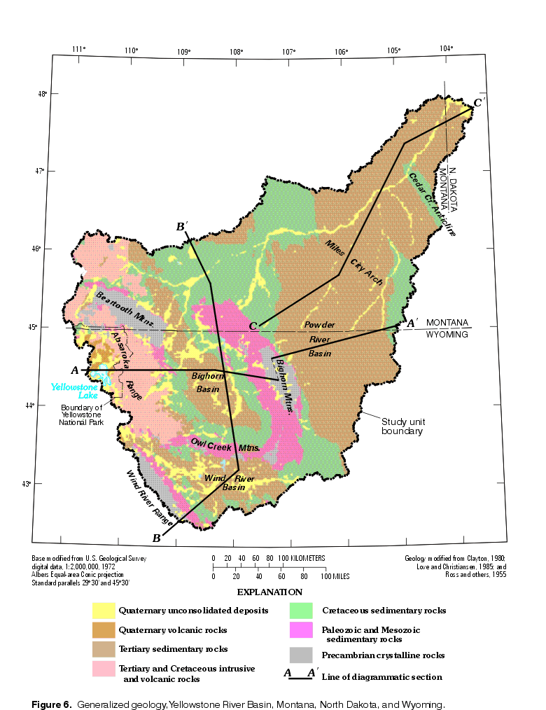 |
| Figure 6. Generalized geology, Yellowstone River Basin. (Click on image for a larger version, 184 kb) |
The distribution and thickness of the geologic units are controlled largely by the tectonic events that produced the basins, uplifts, and associated faults (Whitehead, 1996). Diagrammatic sections illustrating the association between generalized stratigraphy and the principal structural features are shown in figure 7.
 |
| Figure 7. Diagrammatic sections showing principal geologic structures and groupings of geologic units, Yellowstone River Basin. (Click on image for a larger version, 60 kb) |
A generalized correlation chart for Paleozoic, Mesozoic, and Cenozoic rocks (fig. 8) shows that the distribution of geologic units varies considerably across the YRB. Differences in nomenclature between parts of the YRB further complicate the discussion of stratigraphy. The following sections provide an overview of the stratigraphy of the study unit, but for individual description of many of the geologic units shown in figure 8, the reader is referred to the sources from which that figure was compiled.
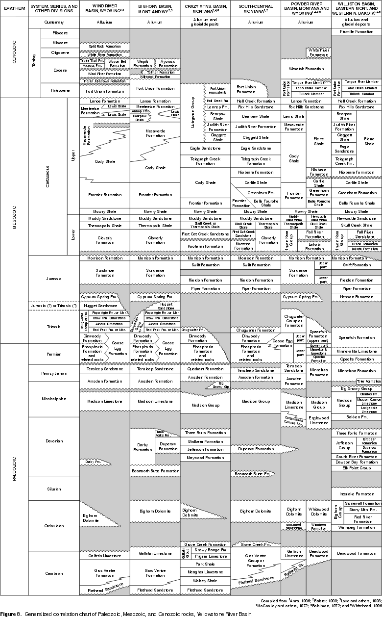 |
| Figure 8. Generalized correlation chart of Paleozoic, Mesozoic, and Cenozoic rocks, Yellowstone River Basin. (Click on image for a larger version, 118 kb) |
The Pre-Cretaceous rocks (Cambrian through Jurassic Systems) frequently are not differentiated with respect to series, groups, or formations on the State geologic maps, and are exposed in only 8.3 percent of the study unit. Where deeply buried, as they are in structural basins, these rocks are beyond the scope of the NAWQA study-unit investigations that focus on shallow ground water and surface water. Paleozoic rocks are exposed at the land surface in discontinuous, often small, and irregular areas within the YRB. These outcrops generally are on the flanks of uplifts or where erosion has exposed the folds of an anticline (Whitehead, 1996).
The Cambrian sequence is exposed in less than 1.4 percent of the study unit. A general decrease in carbonate rocks and an increase in sandstone and conglomerate exists from west to east across the YRB (Lochman-Balk, 1972).
Ordovician strata are exposed in less than 1 percent of the study unit and reach a maximum thickness greater than 240 m in the northeastern extremity of the YRB. Directly overlying Cambrian rocks in much of the YRB, is the Bighorn Dolomite that forms nearly all of the 150 m of Ordovician rocks present in much of northern Wyoming (Boyd, 1993). All Ordovician Formations are absent in the southeastern Powder River Basin (Boyd, 1993; Foster, 1972).
Silurian strata reach a maximum thickness within the study unit of about 220 m at the YRB outlet area, and thin steadily to the southwest (Gibbs, 1972, p. 87). Nowhere in the YRB are Silurian strata exposed at the surface. Devonian rocks are exposed over less than 1 percent of the study unit. The Devonian System is absent in the southeastern part of the study unit, generally thickens toward the northwest and northeast, and reaches a maximum thickness of about 430 m at the YRB outlet area (Baars, 1972, p. 94).
A thick carbonate sequence of Mississippian strata covers the structural basins of the study unit, ranging in thickness from about 60 m in the southeast to about 760 m in the YRB outlet area. In the Montana part of the YRB, thickness increases northward, whereas in Wyoming, thickness increases northward and westward (Craig, 1972, p. 103). Mississippian rocks are exposed over less than 3.5 percent of the study unit. Lower Mississippian rocks include lower and middle sections of the widespread Madison Limestone, or equivalently, the Lodgepole and Mission Canyon Limestones of the Madison Group (Boyd, 1993).
The Pennsylvanian System is less than 100 m thick in the northwestern YRB, thickens gradually to the south and southeast to an average thickness of about 150 m over the southern half of the study unit, and exceeds 210 m of thickness in the southern Powder River Basin (Mallory, 1972, p. 115). Pennsylvanian rocks are exposed over less than 0.5 percent of the study unit.
Permian rocks are exposed over less than 2.5 percent of the study unit. Lower Permian rocks are present only in the southern part of the Powder River Basin and northeastward from there along the eastern edge of the YRB (Boyd, 1993; Rascoe and Baars, 1972). In total, the Permian sequence is thickest in the southeastern part of the study unit, where it exceeds 160 m, and thins to the northwest, wedging out altogether along most of the northwestern margin of the YRB (Rascoe and Baars, 1972, p. 146).
Like the Paleozoic rocks that underlie them, the Triassic and Jurassic Systems are downwarped and deeply buried in the structural basins (Whitehead, 1996). The Triassic System is an eastward-thinning wedge that covers most of the YRB, has a maximum thickness of about 600 m in the southwestern Wind River Basin, and is absent along the northwestern margin of the study unit (MacLachlan, 1972, p. 169). Triassic rocks are exposed over less than 2 percent of the study unit.
The Nugget Sandstone (fig. 8) overlies the Upper Triassic rocks of the Wind River Basin to a maximum depth of about 120 m, but is absent elsewhere in the study unit (MacLachlan, 1972, p. 174). These coarse-grained, crossbedded eolian sandstones may be Upper Triassic in age but, according to Picard (1993), are probably Lower Jurassic.
Jurassic rocks are exposed over less than 1 percent of the study unit. The Jurassic sequence covers all the structural basins of the study unit, is thickest (about 380 m) near the YRB outlet and at the northwest end of the Wind River Range, and thins toward the southeastern and northwestern parts of the YRB (Peterson, 1972, p. 180).
Sedimentary rocks of the Cretaceous System extend over most of the plains and basins of the YRB, but are deeply buried at many locations. Where these rock units crop out, as they do in about 23 percent of the study unit, they usually are tilted and often beveled by erosion. The Lower Cretaceous rocks are thickest in the west and northwest (about 240 m), thin to generally less than 120 m in the east and southeast, and are absent only where removed by erosion on uplifts (McGookey and others, 1972; Steidtmann, 1993). Lower Cretaceous rocks generally outcrop in the YRB only on the flanks of uplifts and anticlines, or where displaced upward along faults.
The Upper Cretaceous rocks exceed 2,400 m in thickness in the southern Powder River and eastern Wind River basins, generally range between 1,200 and 2,400 m elsewhere, but are thinner in the southwestern and northeastern corners of the study unit (McGookey and others, 1972, p. 207). In ascending order, the Upper Cretaceous stratigraphic sequence in much of the YRB is the Mowry Shale, Frontier Formation, Cody Shale, Mesaverde Formation, Lewis Shale, Fox Hills Sandstone, and the Lance Formation. In the Bighorn and Wind River Basins, the marine Lewis Shale and nonmarine Meeteetse Formation interfinger and together occupy the interval between the Mesaverde and Lance Formations (fig. 8).
In the northwestern YRB is a thick Upper Cretaceous sequence of rocks consisting chiefly of volcanic debris that is named the Livingston Group (Roberts, 1972). The group is composed of four nonmarine formations: a basal unit of siltstone and sandstone, overlain by a unit of alternating beds of siltstone and sandstone, a unit of largely mudstone, and an upper unit of sandstone and conglomerate (Roberts, 1972).
A thick sequence of sedimentary rocks of Tertiary age unconformably overlies the eroded Cretaceous surface in most of the plains and basins of the study unit. Tertiary sedimentary rocks are exposed over about 43 percent of the study unit, and Tertiary volcanic rocks are exposed over nearly 8 percent. The Paleocene Fort Union Formation, Eocene Wasatch, Willwood, or Wind River Formations, and Oligocene White River Formation are widely found in the Tertiary stratigraphic sequence. Units other than the Fort Union Formation or equivalents are absent in many places, and Tertiary volcanic rocks are present chiefly in the vicinity of the Absaroka volcanic field.
Paleocene and Eocene sedimentary rocks consist chiefly of sandstone, siltstone, claystone, with interbedded coal and lignite (Whitehead, 1996). The Paleocene Fort Union Formation is widespread in three of the major structural basins of the study unit: the Bighorn, Powder River, and Wind River Basins. However, in the Eocene interval the different basins of the study unit display contrasting stratigraphy (fig. 8).
The Eocene rocks of the Absaroka volcanic field were named the Absaroka Volcanic Supergroup (Smedes and Prostka, 1972) because three stratigraphic groups are included: in ascending order, the Washburn Group, Sunlight Group, and Thorofare Creek Group. No column for this volcanic field is included in the generalized correlation chart (fig. 8); the reader is referred to Sundell (1993) for a recent overview. The Washburn Group is the oldest part of the volcanic deposits and makes up much of the northern Absaroka Range. Farther south, it is overlain by rocks of the Sunlight Group. Due to the lack of regional marker beds, correlations between different areas of the Absaroka volcanic field are not well established. The stratigraphy is greatly complicated by multiple source areas, reworking, and post-depositional deformation including regional tectonism, volcanism, and mass movements (Sundell, 1993).
Oligocene and Miocene sedimentary rocks consist mostly of semiconsolidated claystone, siltstone, sandstone, with some conglomerate (Whitehead, 1996). The Oligocene White River Formation is widespread in the south and eastern parts of the study unit, but is absent in the Bighorn Basin. According to Love and others (1963), at the conclusion of the period of Miocene deposition, only scattered knobs of Precambrian basement rocks protruded from the thick blanket of sedimentary rocks. Within the study unit, the Miocene is represented primarily by the Split Rock Formation in the Wind River Basin and the Colter Formation on the Yellowstone Plateau.
A great variety of Quaternary deposits occur within the study unit, including eolian, fluvial, glacial, landslide, and volcanic deposits. Valley-fill deposits consisting of unconsolidated gravel, sand, silt, and clay occur adjacent to most of the larger streams of the study unit (Whitehead, 1996). Although unconsolidated deposits, commonly being quite permeable and often located along streams, are likely to be important for understanding hydrology and water quality, they are not further discussed in this section because their spatial heterogeneity is so great that brief treatment is of minimal value. Of the consolidated Quaternary deposits, particular attention is given to the Quaternary volcanic rocks composing the Yellowstone Plateau.
The rocks of the Yellowstone Plateau are almost exclusively rhyolites and basalts, with the rhyolites being greatly predominant (Christiansen and Blank, 1972). The welded ash-flow tuffs that largely compose the outer part of the plateau are separated by unconformities into three major ash-flow sheets. The tuffs overlie rocks from the Precambrian through Quaternary Systems, but in the eastern plateau they chiefly overlie Eocene rocks of the Absaroka Volcanic Supergroup. At the center of the plateau, rhyolitic lava flows cover and partly fill the enormous elliptical caldera formed as a result of the eruption of the oldest ash-flow sheet.
The northeastern part of the study unit was subjected to three periods of glaciation that have not been radiometrically dated, but most likely the early Wisconsinan advance more than 20,000 years ago was the most recent glaciation (Clayton and others, 1980). Along the Yellowstone River valley, a high terrace surface (119 m above the river near Glendive, Mont.) converges with the present floodplain in the upstream direction. The two surfaces are only 38 m apart east of Billings, Mont. The upstream convergence of the two surfaces suggests that downcutting of the Yellowstone River was the result of base-level lowering following retreat of the ice sheet that had blocked the northeast-flowing rivers of Montana (Johns and others, 1982). During one of the glacial advances, the Missouri and Yellowstone Rivers apparently flowed into North Dakota at a point about 18 km south of where the present Yellowstone River crosses that boundary (Clayton and others, 1980). The transport of water and sediment from the upper Missouri River through that relict valley potentially could be reflected in distinctive alluvial ground-water characteristics.
Glacial sediments, other than scattered lag boulders, are found only behind the terminus of the most recent glacial advance into the study unit; there, lag boulders abound and glacial sediment is widely preserved (Clayton and others, 1980). Although about 2.5 percent of the YRB was subjected to continental glaciation (Fenneman and Johnson, 1946), less than 0.5 percent is presently overlain by sediments deposited by continental glaciation (Clayton, 1980).
Alpine glaciation was widespread in the high mountainous areas of the YRB during the Pleistocene Bull Lake and Pinedale Glaciations. During the Pinedale Glaciation, about 13,000 to 30,000 years ago, major ice streams from four source areas converged to form the northern Yellowstone outlet glacier that flowed 60 km down the Yellowstone valley (Pierce, 1979). Ice from the Pinedale icecap on the Yellowstone Plateau also flowed into adjacent basins and out to other glacial termini, some of which were outside the study unit. During the late Pleistocene, mountain glaciers in places extended several kilometers beyond canyon mouths onto basin floors (Mears, 1987). The icecap on the Beartooth uplift was a source area for numerous glaciers, the northern Yellowstone outlet glacier among them (Pierce, 1979).
Although their size and elevation were probably the most important factors affecting the glacial productivity of the source areas, geographic location with respect to incoming storms was also very significant (Pierce, 1979). Many storms probably moved eastward from the Pacific Northwest and dropped great amounts of snow when forced to rise over the icecaps on the Yellowstone Plateau (Pierce, 1979), Beartooth Mountains, and Wind River Range.
Today, only small remnant glaciers are present in the study unit, mostly concentrated in the Beartooth and Wind River Mountains. But glacial and periglacial landforms are quite extensive. Many of the mountain streams flow through U-shaped valleys characteristic of alpine glaciation. Pinedale Till, and Bull Lake Till at locations beyond the maximum limit of Pinedale Glaciation, dominate the lower hillslopes of many mountain valleys. Glacial-outwash terraces stand higher than Holocene stream terraces and present-day floodplains in many stream valleys.
Seismicity of the region, based on earthquake frequency and intensity, was described by Simon (1972). The westernmost section of the study unit has been an area of moderate seismic activity, whereas seismicity in the Bighorn and Wind River Basins has been substantially less (Simon, 1972, p. 50). Substantial areas where no recorded earthquakes have occurred include the Powder River Basin and the Beartooth and Bighorn Mountains. Most of the strong earthquakes in the study area have occurred in the vicinity of Yellowstone National Park, where the Yellowstone caldera lies at the apex of a parabola-shaped zone of seismicity with the axis centered on the eastern Snake River Plain of Idaho (Smith and Braile, 1993). As early as 1871, F.V. Hayden recognized that Yellowstone was at a great volcanic center and, after experiencing several earthquake shocks while camped along Yellowstone Lake, remarked that, "I have no doubt that if this part of the country should ever be settled and careful observations made, it will be found that earthquake shocks are of very common occurrence" (Hayden, 1872). Yellowstone Lake has persisted as a notable area of earthquake swarms (Smith and Braile, 1993).
The significance of seismic activity as a factor potentially affecting water quality is illustrated by the 1959 earthquake and associated landslide in the Madison River valley of Montana (just west of the YRB). That event deposited 32 million m3 of colluvium on the canyon floor, impounding water behind a 60-m high rock dam it created (Dunne and Leopold, 1978).
Most of the coal deposits in the YRB are located in the nearly horizontal Tertiary beds in the structural basins of the Northern Rocky Mountains and Northern Great Plains coal regions. Coal beds within the Paleocene Fort Union Formation are as much as 43 m thick (Flores, 1996). Vast amounts of subbituminous coal are found in extensive beds that are thick enough and near enough to the surface to be considered strippable deposits.
"Coals from the Powder River Basin analyzed for Hazardous Air Pollutants named in the 1990 Clean Air Act Amendments indicate lower * * * [pollutant] content than other coals from within this region and other regions in the United States. Thus, the unique chemical characteristics and thickness of these Fort Union coals make them an important resource for continued and expanded use within current and future environmental constraints" (Flores, 1996).
In the Bighorn Basin, the coal-bearing rocks are exposed around the rim of the basin in a belt 5 to 24 km wide, and consist of the Upper Cretaceous Mesaverde, Meeteetse, and Lance Formations and the Paleocene Fort Union Formation (Berryhill and others, 1950). Coal-bearing formations in the Wind River Basin crop out only around the basin rim and are overlain by thick units of younger, non-coal-bearing rock in the central part (Berryhill and others, 1950). Because coal beds in the Wind River Basin are relatively thin and steeply dipping, they are economically insignificant compared to those in the Bighorn Basin, which are small in comparison with those in the Powder and Tongue River Basins (Peterson and others, 1987). The aggregate thickness of coal in the Fort Union Formation exceeds 90 m in the Powder River Basin (Barlow and others, 1993), but many coal beds are discontinuous, "pod-shaped" deposits (Flores, 1997).
Coal beds also are important reservoirs of methane-rich gas, only recently recognized to represent an enormous "unconventional" energy resource (U.S. Geological Survey, Energy Resource Surveys Program, 1997). Large quantities of water, sometimes saline, are unavoidably produced along with the methane gas. Fractures that permeate coal beds are usually filled with water; the deeper the coal bed, the less water usually present, but the more saline it becomes (U.S. Geological Survey, Energy Resource Surveys Program, 1997).
Hydrocarbon minerals include natural gas and oil, in addition to the coal-bed methane just discussed. Productive reservoirs of hydrocarbon minerals in the Rocky Mountains and Northern Great Plains region are found in strata from the Cambrian through Tertiary Systems (Spencer, 1996). An estimated 99 billion m3 of gas and 2.5 billion barrels of oil are yet undiscovered, technically recoverable resources in the Bighorn, Powder River, and Wind River Basins (U.S. Geological Survey, 1996a).
In the Powder River Basin, hydrocarbon reservoirs are located mostly in Cretaceous or Paleozoic rocks; reservoirs in the Bighorn Basin are typically in Paleozoic rocks; and in the Wind River Basin, reservoirs in Paleozoic, Cretaceous, and Tertiary rocks are common (DeBruin and Boyd, 1991).
"In general, Paleozoic reservoirs are marine and eolian sandstone and marine carbonate and produce mostly oil and associated gas. Mesozoic reservoirs are mostly marine and fluvial sandstone; the Cretaceous is by far the dominant age of Mesozoic producing rocks. The Cretaceous produces oil and associated gas and non-associated gas. Tertiary reservoirs are dominantly continental, lenticular sandstone and * * * produce mostly gas" (Spencer, 1996).
Paleozoic hydrocarbon reservoirs include a few stratigraphic traps, such as at Cottonwood Creek in the Bighorn Basin, where the Permian Phosphoria Formation and related rocks are the reservoir rocks. The Pennsylvanian Minnelusa Formation also contains many stratigraphically trapped oil reservoirs in the Powder River Basin (DeBruin, 1993). Most of the many important Paleozoic reservoirs in the Bighorn Basin are associated with anticlines around the basin margins. Sandstone reservoirs of the Pennsylvanian Tensleep Sandstone, and carbonate reservoirs of the Phosphoria Formation and Mississippian Madison Limestone are among the major reservoirs of oil and gas (DeBruin, 1993).
In the Lower Cretaceous Series, the Muddy Sandstone hydrocarbon reservoirs are predominantly stratigraphic traps in the Powder River and Wind River Basins (Mullen and Barlow & Haun, Inc., 1993). The Frontier Formation is the major Upper Cretaceous hydrocarbon reservoir in the study unit. Within the YRB, major oil and gas reserves in the Frontier Formation are associated with nearshore marine sandstones and reworked marine sandstones (Doelger and others, 1993). The nearshore marine sandstone of the Frontier Formation is particularly important at the Salt Creek and Teapot fields north of Casper.
In the Tertiary System, the Paleocene Fort Union Formation produces gas in two separate areas of the YRB. Several reservoirs are located in the interior of the Wind River Basin, and sandstone reservoirs associated with coal beds are found in the northeastern Powder River Basin (DeBruin and Boyd, 1991).
Mineral deposits are the result of specific geologic processes and thus occur only in those geologic environments where those processes have been active (Anderson and others, 1993), or where mineral-enriched material eroded from those deposits has been re-deposited in sufficient concentration to produce secondary enrichment. Only a small fraction of any area is likely to contain recoverable mineral deposits, and such is the case for the study unit, where about 2 percent of the total area lies in the principal areas of metallic mineral deposits (fig. 9). Known, potentially important metallic mineral deposits are found in each of the major structural units of the YRB, except the Williston Basin. Uranium mineralization is particularly widespread, occurring in most of the stratigraphic units (Harris and King, 1993). Important or substantial mineral-deposit areas are discussed separately by structural unit in this section of the report.
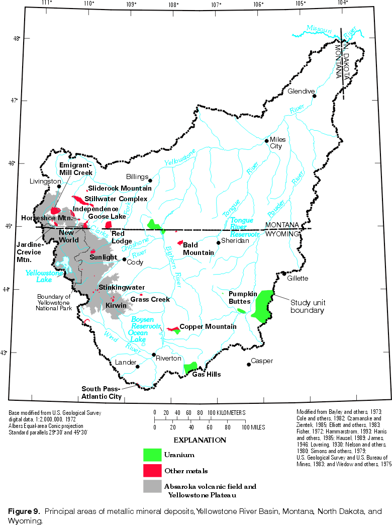 |
| Figure 9. Principal areas of metallic mineral deposits, Yellowstone
River Basin. (Click on image for a larger version, 91 kb) |
In the Absaroka volcanic field (fig. 9), the geologic environment associated with metallic mineral deposits consists of deeply eroded intrusive centers (volcanic-plutonic complexes), where the plutonic component represents the solidified magma chamber beneath the former volcano (Hammarstrom and others, 1993). Mineralization associated with Absaroka intrusive centers generally occurs as disseminations and stockworks in intensely altered rock and in fractures and veins. Hydrothermal alteration typically produced crudely zoned mineralization around the core of the intrusive complex. Porphyry copper deposits (veinlets and disseminated grains of copper-bearing minerals in plutonic rocks) may occur in the center of the complex (Hammarstrom and others, 1993), often associated with molybdenum, and sometimes traces of gold. Copper-gold skarns and replacement deposits form in limestone when adjacent to the complex; and zinc-lead-silver vein deposits (sulfide minerals containing large concentrations of these, and sometimes gold or other, minerals) occur laterally away from the center along faults and shear zones (Hammarstrom and others, 1993). In addition to the porphyry copper deposits, heavy minerals such as gold may also be found in placer deposits downstream from porphyry districts (Hausel, 1989).
Due to the presence of several large, porphyry copper deposits, the Absaroka Range has definite potential for becoming a metals mining district (Hausel, 1989). Within the Absaroka Range there are four substantially mineralized areas: the Kirwin, New World, Stinkingwater, and Sunlight districts (Nelson and others, 1980).
Several intrusive complexes penetrate the Eocene volcanic rocks of the Kirwin area (fig. 9). The layered, vent-facies volcanic rocks have been domed, hydrothermally altered, and radially fractured (Hausel, 1989). Copper, silver, molybdenum, and gold deposits are known.
The New World district (fig. 9), also known as the Cooke City district, was discovered in the 1860s. It is located in an eruptive center, but uplift and erosion have removed most of the volcanic material and exposed Precambrian gneiss, Paleozoic rocks, and Tertiary intrusive rocks throughout much of the district (Elliott, 1980b). With few exceptions, major ore bodies are localized adjacent to the stocks and mineralization extends outward in irregular metallogenic zones, from copper-gold-silver skarn and replacement deposits near intrusions to distal lead-zinc-silver vein deposits (Hammarstrom and others, 1993b; Hausel, 1989). Many of the copper-gold-silver deposits are gold-bearing skarns that formed in carbonate rocks, in breccia, and along faults (Hammarstrom and others, 1993b). Silver-lead-zinc ores occur in fissure-replacement deposits intruding into Paleozoic limestone south of Cooke City, more than 4 km south of the intrusive centers (Lovering, 1930). Since 1990, considerable exploration and development have focused on five copper-gold-silver deposits in the New World district (Hammarstrom and others, 1993a).
The Stinkingwater district (fig. 9) includes several mineralized porphyries. Mineral deposits in the Stinkingwater area include disseminated sulfide minerals in altered rocks adjacent to granodiorite and dacite intrusive stocks, and fracture-filling veins in adjacent, layered volcanic rocks (Hausel, 1989). Metal zonation is characterized by a central copper-molybdenum zone surrounded by a zone of veins bearing silver, gold, lead, zinc, arsenic, and possibly mercury (Fisher, 1972). Streambed sediments in the vicinity of this mineralized area contain small amounts of gold and mercury (Fisher, 1972).
Both disseminated deposits and vein mineralization occur in the Sunlight district (fig. 9). Disseminated deposits are localized around intrusives and include pyrite in altered zones, chalcopyrite in intrusive rocks, and copper-bearing stockworks (Hausel, 1989). Copper enriched veins tend to be near the stocks, and lead-silver bearing veins are found at distance from the intrusions (Elliott, 1980a). Samples of vein material collected in 1970 from 40 locations in the Sunlight mining region were analyzed spectrographically and showed consistently minor amounts of gold but locally substantial amounts of silver, copper, and lead (Nelson and others, 1980). Results of sampling bedrock and streambed sediment indicate a copper-gold zone associated with syenite stocks in the south and east part of the Sunlight region, and a lead-silver zone in the north and east (Elliott, 1980a).
Mineral deposits in the Beartooth uplift are of diverse types and metal suites (U.S. Geological Survey and U.S. Bureau of Mines, 1983). Six primary areas of mineral deposits are known in the western Beartooths: the Emigrant-Mill Creek area, Independence (Boulder) district, and Horseshoe Mountain area are associated with Tertiary intrusive rocks; the Goose Lake area is associated with a Cretaceous intrusion; and the Jardine-Crevice Mountain (Sheepeater) district and Stillwater Complex are in Precambrian rocks. In the eastern Beartooths, the Red Lodge chromite district is the primary known mineral area. North of the Beartooth Mountains front, is the Sliderock Mountain area, containing Cretaceous volcanic and intrusive rocks (Elliott and others, 1993).
In the Emigrant-Mill Creek area (fig. 9), numerous small deposits include such metals as copper, molybdenum, gold, silver, lead, zinc, tungsten, bismuth, manganese, and iron. The Emigrant stock and several smaller dikes, sills, and laccoliths intrude Precambrian gneiss and schist, Paleozoic sedimentary rocks, and Tertiary volcanic rocks (Elliott and others, 1983). Hydrothermal alteration, including widespread pyritic alteration, decreased with intensity outward from the stock and produced a zonation of metallic mineralization. Copper and molybdenum are concentrated near the center of the stock, gold is near its periphery, and lead, zinc, and silver occur mostly near or outside the stock periphery (Elliott and others, 1983). The placer gold deposits of Emigrant Creek were a particularly large and productive mineral resource (Hammarstrom and others, 1993).
In the Independence district (fig. 9), an Eocene intrusion into rocks similar to those at the Emigrant stock is associated with a suite of metals also similar to those in the Emigrant-Mill Creek area (Elliott and others, 1983). Zonation of the altered and mineralized rocks is again evident and is typical of porphyry copper systems (Hammarstrom and others, 1993b). The intrusive rocks of the area are more mafic than those of the Emigrant-Mill Creek area, and therefore considered to have less mineral potential for copper and molybdenum (Elliott and others, 1983). Placer gold is present in most of the surrounding streams (Hammarstrom and others, 1993b).
An altered dacite porphyry at Horseshoe Mountain (fig. 9), midway between the Cooke City and Independence districts, has been historically prospected for gold in both lode and placer deposits. Geochemical anomalies for molybdenum, tungsten, precious- and base-metals have been detected in sediments of streams draining this area (Hammarstrom and others, 1993b).
The Goose Lake area (fig. 9), located in the headwaters of the Stillwater River at the northeast corner of the New World district, contains mineralization associated with a locally altered Late Cretaceous syenite stock intruding Precambrian granitic gneiss. The deposit is considered an unusual occurrence of copper-gold-platinum mineralization that is an example of a magmatic segregation deposit associated with alkaline gabbros and syenites (Hammarstrom and others, 1993b). The principal minerals are chalcopyrite and bornite, occurring as disseminations and vein fillings. Shear zones away from the syenite stock also are mineralized (Simons and others, 1979). Copper, gold, silver, platinum, palladium, lead, and tungsten are present.
Gold discovered in placer deposits in 1862 led to discovery of gold-bearing quartz veins at Jardine in 1870. Substantial deposits of gold, arsenic and tungsten are present, as confirmed by geochemical analyses of rock and stream-bed sediment samples (Wedow and others, 1975). Extensively folded Precambrian metasedimentary rocks contain quartz veins and shear zones that are concentrated in two distinct belts, one through Mineral Hill and the other through Crevice Mountain (Hammarstrom and others, 1993b). The geologic setting of the Jardine-Crevice Mountain deposits (fig. 9) is typical of the metasedimentary parts of ancient greenstone belts, and the deposits are similar to other lode gold systems associated with a banded iron formation (Hammarstrom and others, 1993b).
Mineral deposits of the Stillwater Complex (fig. 9) include chromium, nickel, copper, and platinum-group elements (PGE). The deposits are stratiform and exhibit great lateral continuity (Elliott and others, 1983). The nickel-copper deposits are concentrated at the base of the complex as sulfide-rich zones that have been identified as large tonnage, low-grade resources (Zientek, 1993). PGE occur near the base of the complex and also a few thousand meters above the base in a thin, laterally persistent interval of PGE-enriched disseminated sulfide mineralization (Zientek, 1993). The Stillwater Complex contains the largest identified resources of PGE and chromium in the U.S., in addition to major nickel and copper resources (Hammarstrom and others, 1993a). Undiscovered deposits of copper, nickel, chromium, and platinum-group elements are likely to be present in the complex (Zientek, 1993).
Chromite was discovered in the Red Lodge district (fig. 9) in 1916 (James, 1946). The Red Lodge chromite occurs as lenses in masses of serpentinite intruded into granitic gneiss and is exposed at the edges of plateaus at an elevation of about 3,000 m (Simons and others, 1979). The relatively low-grade chromite deposits have been highly metamorphosed, tectonically disrupted, and isolated (Hammarstrom and others, 1993b). The deposits are dissimilar from the stratiform deposits in the Stillwater Complex (James, 1946). The mineral resources remaining in this district are relatively small, many deposits having been completely mined out.
The Sliderock Mountain area (fig. 9) features a diorite stock surrounded by lahar deposits, andesite flows, and flow breccias. Concentrically zoned hydrothermal alteration and geochemical anomaly patterns indicate the presence of a shallow subsurface porphyry copper-gold deposit (Hammarstrom and others, 1993b). Silver, lead, zinc, and molybdenum also are present.
The Precambrian granites and gneisses of the Bighorn Mountains are not considered likely hosts for major precious metal occurrences, but the possibility cannot easily be dismissed (Hausel, 1989). The known precious metal deposits are associated with mafic dikes, veins, and shear zones in the Precambrian core and with core debris in placers in the overlying Cambrian Flathead Sandstone. In the Bald Mountain area (fig. 9), mineral-enriched conglomerates in the Flathead Sandstone contain gold and other heavy minerals, such as ilmenite, magnetite, zircon, and monazite. Other minor deposits of metals in the Bighorn Mountains contain tungsten, silver, manganese, copper, and gold in quartz veins (Hausel, 1989); and numerous small deposits of uranium and vanadium are known in the Little Mountain area (Van Gosen and others, 1996).
In the eastern Owl Creek Mountains (fig. 2), Precambrian metamorphic rocks are exposed in the Copper Mountain district (fig. 9), which includes several known mineralized areas. In the western end of the district, a vein bearing sporadic sulfides and gold represents a relatively small deposit. Near the center of the Copper Mountain district, quartz veins and a banded iron formation are known to contain copper, titanium, gold, and silver (Hausel, 1989). In the eastern end of the district, a mafic dike is fractured and quartz veins fill the fractures; both the veins and the dike are mineralized with copper, nickel, gold, and silver (Hausel, 1989). Also at Copper Mountain, uranium mineralization occurs in the Eocene Tepee Trail Formation and in altered rocks, breccia zones, and fractures in the underlying Precambrian rocks (Yellich and others, 1978).
Numerous uranium-vanadium deposits were discovered in the Pryor Mountains (fig. 2) during 1955-58 (Van Gosen and others, 1996). These deposits are mostly small and are hosted by shallow collapse structures in the upper third of the Madison Limestone. The mineral deposits are found mostly within vugs, open fractures, and the most permeable cavern-fill materials (Van Gosen and others, 1996).
In the Bighorn Basin, titaniferous black sandstone deposits, hosted primarily in the Upper Cretaceous Mesaverde Formation, are found in several locations, with the Grass Creek deposit (fig. 9) being the largest high-grade deposit in Wyoming (Hausel, 1993). These deposits contain abundant heavy minerals, including zircon, monazite, and gold, in addition to titanium-bearing minerals (Hausel, 1989).
Uranium deposits (fig. 9) of economic significance in the Powder River Basin occur primarily in the Wasatch Formation of Tertiary age (Hausel, 1982). Most economic uranium deposits in the YRB are found in arkosic Eocene and Paleocene sandstones and conglomerates of continental origin, in which uranium minerals coat the grains and partly fill the interstices (Butler, 1972). Mineralization dominantly occurs as "roll-front" deposits located at contacts between oxidized (altered) and reduced (unaltered) zones (Hausel, 1982). Uranium, being soluble in the oxidized state but not in the reduced state, is readily leached from the oxidized rocks and deposited in zones where geochemical conditions change from oxidizing to reducing (Lowry and others, 1993). Uraniferous tuffaceous units, such as the Oligocene White River Formation, are the probable source of the leached uranium in the Powder River Basin (Harris and King, 1993).
Radium deposits are also found in Tertiary sediments, such as with uranium in concretionary occurrences in the Pumpkin Buttes (fig. 9) area (Harris and King, 1993). Radium is soluble in water, regardless of oxygen availability, but is strongly adsorbed by manganese and iron oxides, so its presence in an oxidizing environment varies with those of the manganese and iron oxides (Harris and King, 1993). There is no present economic interest in radium deposits, as it is readily available from production in nuclear reactors.
In the Gas Hills (fig. 9) uranium district at the southern end of the Wind River Basin, substantial uranium deposits occur in the Wind River Formation of Tertiary age (Hausel, 1982) and may be derived from leached or eroded uranium in the Precambrian granites of nearby mountains (Harris and King, 1993). Wyoming contains more than half of the Nation's uranium reserves (U.S. Dept. of Energy, Energy Information Administration, 1997), and a substantial percentage is located within the YRB in the Powder River and Wind River Basins.
Alluvial gravels along the Wind River, Little Wind River, and Popo Agie River (not labeled on
figures) contain gold, commonly occurring as very fine particles. The largest concentrations known were found in Wind River placer deposits west of Riverton and in a downstream reach now mostly submerged in Boysen Reservoir (Hausel,1989). Other placer deposits of gold and monazite occur in terrace deposits and gravels of Warm Spring Creek (not shown in figures) in the northern Wind River Range (Hausel, 1989). Placer gold also has been found in gravels of several other eastward-flowing streams draining the Wind River Range to the south.
The South Pass-Atlantic City (fig. 9) greenstone belt is known for rich deposits of gold and iron ore. The complexly folded rocks of the greenstone belt extend into the study unit at the southeast end of the Wind River Range (Hausel, 1989). Substantial lode deposits of silver, gold, and copper occur in shear-zone structures and quartz veins. Also, banded iron formation, or taconite, deposits are located along the northwestern flank of the greenstone belt.
Near the greenstone belt, precious-metal bearing Oligocene conglomerates were deposited as a giant alluvial fan at the mountain front. The source of the metals in the Oligocene conglomerate is believed to be a small area of metamorphic rocks cut by veins and probably now buried by strata of the Oligocene White River Formation (Antweiler and others, 1980). Other Tertiary conglomerates in this same general area are known to contain precious metals (Hausel, 1991).
Return to Environmental Setting of the Yellowstone River Basin, WRIR 98-4269