 |
| Figure 23. Ecoregions, Yellowstone River Basin. (Click on image for a larger version, 82 kb) |
Several sources of information are available that show the geographic distribution of environmental settings at national or continental scales as analyzed by previous investigators. Such settings integrate many interrelated characteristics, such as climatic, physiographic, geologic, biotic, and land-use features. One of the benefits of developing a regional framework of environmental settings is its use in selecting regional reference sites (Gallant and others, 1989). Such sites are used within the NAWQA Program to represent unimpaired or relatively unimpaired water-quality conditions for a specific environmental setting. Water-quality data collected from impaired sites can then be compared with those from environmentally similar reference sites.
Ecosystems of regional extent, also known as ecoregions, have been defined and mapped by a number of investigators. Two of the more widely used classification systems for ecoregions of the U.S. are those developed by R.G. Bailey and J.M. Omernik.
Bailey's ecoregions (1:7,500,000 scale) (Bailey and others, 1994) are based on associations of environmental factors that directly affect or indirectly express energy, moisture, and nutrient gradients that control the structure and function of ecosystems; these factors include climate, landforms, vegetation, and soil (Bailey, 1996). In Bailey's hierarchical system, developed to support ecosystem management on land administered by the U.S. Forest Service, the YRB lies in the dry climate domain, a subcontinental region of broad climatic similarity. Within the dry domain, several divisions are defined by vegetation differences corresponding to the levels of water deficit and winter temperatures (Bailey, 1995). Two of these divisions occur in the YRB. Eighty-two percent of the study unit is classified as temperate steppes, areas having shortgrass prairie or semidesert vegetation that is generally sparse, leaving much exposed soil (Bailey, 1995). Bailey maps the remainder of the YRB as temperate deserts, where vegetation is typically semidesert shrubs such as sagebrush.
Bailey's delineation places 53 percent of the study unit in the Great Plains Dry Steppe Province, characterized by grasslands with scattered trees and shrubs. Another 29 percent of the YRB lies in the Southern and Middle Rocky Mountain Steppe Provinces where local vegetation zones are controlled by a combination of altitude, latitude, prevailing winds, and slope exposure (Bailey, 1995). The Intermountain Semidesert Province occupies about 18 percent of the study unit and features sagebrush mixed with short grasses. On moist, alkaline soils, greasewood is an abundant shrub.
At the same scale of 1:7,500,000, Omernik (1987) mapped the principal ecoregions of the U.S. based on integrated patterns of a combination of factors including land use, morphology, potential natural vegetation, and soil. Omernik's map was developed specifically in support of water-resources management and is based on the premise that regional patterns of these environmental factors would be reflected in water-quality patterns (Gallant and others, 1989). Planned applications for the ecoregion maps include development of regional biological criteria and water-quality standards, and establishment of management goals for nonpoint-source water pollution (U.S. Environmental Protection Agency, 1996a).
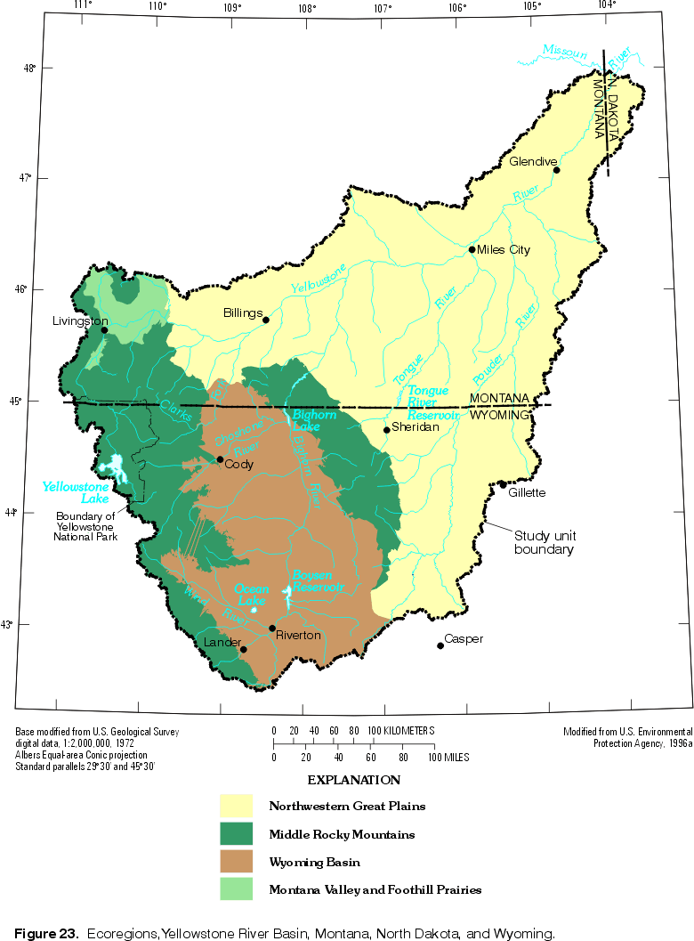
The authors have attempted to refine the current version of Omernik's ecoregions (U.S. Environmental Protection Agency, 1996a) within the YRB to more closely follow changes in land cover and geology seen on larger-scale sources of map data. Additional rationale for modification to the national-scale ecoregion map is found in the results from an adjacent NAWQA study unit, where patterns in fish-species distributions and assemblages did not correspond well with those ecoregion boundaries (Maret and others, 1997). On our modified map of Omernik's ecoregions (fig. 23), 55 percent of the study unit lies within the Northwestern Great Plains. This ecoregion has plains with open hills of varying height and tablelands of moderate relief; and predominant land cover is subhumid grasses used for grazing (Omernik, 1987). Twenty-one percent of the YRB lies in each of two other ecoregions, the Middle Rocky Mountains and the Wyoming Basin. The Middle Rocky Mountains ecoregion features high mountains covered by Douglas fir, western spruce-fir forests, and alpine meadows (Omernik, 1987); land use includes grazing and silviculture. The Wyoming Basin has plains with hills or low mountains, some irrigated agriculture, and potential natural vegetation is shrub steppe, desert shrubland, and juniper-pinyon woodland (Omernik, 1987). The remainder of the YRB lies in the Montana Valley and Foothill Prairies ecoregion, characterized as subhumid grassland used for grazing, and some irrigated land (Omernik, 1987).
|
| Figure 23. Ecoregions, Yellowstone River Basin. (Click on image for a larger version, 82 kb) |
Natural and anthropogenic factors, such as geology and land use, provide a framework for making comparative assessments of water quality within and among hydrologic systems at a range of scales and in different parts of the Nation (Gilliom and others, 1995). Characterizing this environmental framework is an important element in each study-unit investigation of the NAWQA Program. The environmental setting of a study unit is characterized by dividing it into several subareas (not necessarily contiguous) that have relatively homogeneous combinations of those natural and anthropogenic factors believed to be relevant to water quality (Gilliom and others, 1995). In terms of a design for a scientific study, this process is called stratification.
Six environmental data layers were included in a digital map overlay analysis to identify relatively homogeneous subareas for use in designing the YRB study-unit investigation. Three of the data layers have complete geographic coverage for the YRB: ecoregions, geologic units, and land cover or land use. The other three data layers are composed of localized areas where mineral deposits and (or) extraction activities occur or have a substantial likelihood of occurring: coal lease areas, metallic mineral deposits, and oil fields.
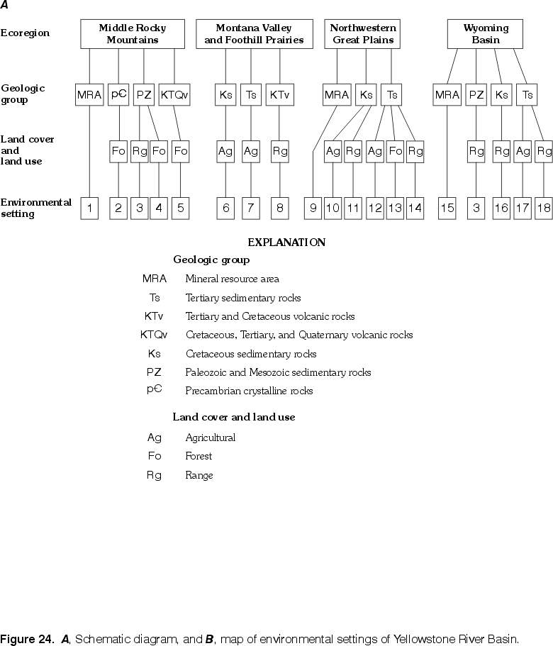
A three-tiered approach was used to stratify the study unit on the basis of environmental settings. Ecoregions represent an integration of multiple environmental controls and were distinguished by Omernik (1987) partly based on expected influence on water quality. Therefore, the four ecoregions (fig. 23) were selected as the first tier for the environmental stratification process.
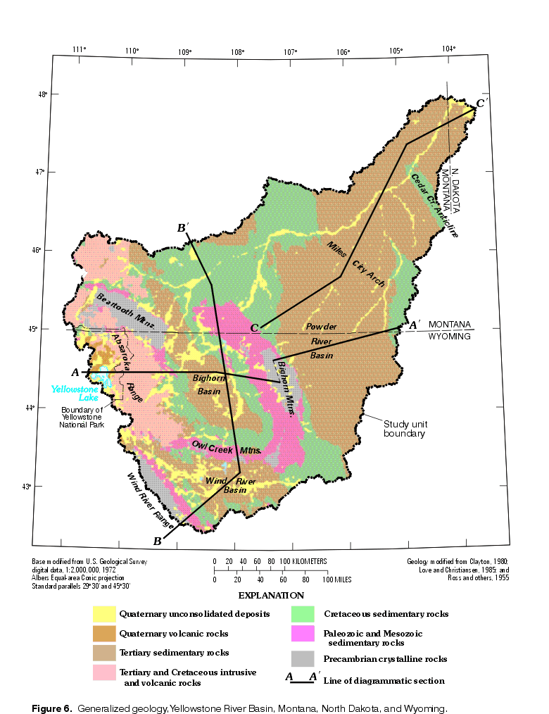
Geologic groups were selected as the second tier. The areas where mineral deposits and (or) extraction activities occur or may be likely were combined to form one geologic group, called mineral resource areas. The remainder of the study unit was assigned to geologic groups on the basis of generalized geologic units (fig. 6). Igneous rocks were grouped into Precambrian crystalline rocks and Cretaceous through Quaternary volcanic and intrusive rocks. The crystalline rocks crop out mainly at the core of three of the mountain uplifts in the YRB and typically produce water-quality characteristics distinct from either volcanic or sedimentary rocks (see Water-Quality Characteristics section of report). Sedimentary rocks were grouped into a "Paleozoics" group that also includes Mesozoic strata (Jurassic and Triassic rocks), a Cretaceous group, and a Tertiary group. Paleozoic units include numerous carbonate strata that exert a substantial influence on both water chemistry and hydrology. Water in Cretaceous aquifers typically contains considerably larger concentrations of dissolved solids than do many Tertiary aquifers. The areas of Quaternary unconsolidated deposits were assigned to the nearest neighboring geologic unit, and grouped accordingly.
For the third tier, land cover and land use, the categories used are those designated as Level I categories in the Anderson (1976) classification system. These major groupings of land cover and land use are associated with different, though generalized, expected impacts on water-quality characteristics.
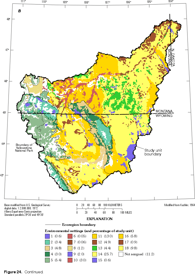
The results of the digital map overlay analysis were a large number of types of relatively homogeneous areas--many more than could be considered as separate environmental settings for the study design. Therefore, selected types of relatively homogeneous areas were designated as environmental settings. Selections were made first based on NAWQA Program priorities, and then based on relative areal extent within the study unit.
Specific environmental settings have been prioritized by the NAWQA Program for sampling by study-unit investigations, such as urban, agricultural, and mining areas. However, NAWQA is targeting large urban areas that have populations greater than 250,000 (Lopes and Price, 1997). In the YRB, no urban areas are large enough to qualify as targets for study. Mineral resource areas were given priority. The environmental factor combinations of mineral resource areas that were most a really extensive were selected as environmental settings, whereas less extensive factor combinations were left unassigned to any setting. For example, 91 percent of the metallic mineral deposits were located in five types of relatively homogeneous areas occurring in three ecoregions; consequently, those five types of relatively homogeneous areas were assigned to an environmental setting according to ecoregion, but the other 9 percent of the metallic mineral deposits were left unassigned. Areas of coal and oil resources were prioritized similarly.
After the higher priority environmental-setting assignments had been made, areal extent was used to rank the remaining combinations of environmental factors. Generally, factor combinations that covered at least 1.5 percent of the study unit were assigned to environmental settings. The notable exception to this generalization is that alpine tundra areas were not assigned to any setting even though two combinations (combinations of tundra with the Precambrian and volcanic geologic groups) do cover about 1.5 percent of the study unit. Alpine tundra areas do not carry sufficient priority within the NAWQA Program to warrant specific consideration for study.
 |
 |
| Figure 24 A. Schematic diagram, Yellowstone River Basin. (Click on image for a larger version, 39 kb) | Figure 24 B. Map of environmental settings, Yellowstone River Basin. (Click on image for a larger version, 114 kb) |
A total of 18 environmental settings (fig. 24 A) were thus defined for the YRB. Relatively homogeneous areas from different ecoregions were not assigned to the same environmental setting, except in one case. Rangeland underlain by the Paleozoic geologic group in both the Middle Rocky Mountains and Wyoming Basin ecoregions were assigned to the same environmental setting because this geologic group mainly occurs in the transitional areas along the boundary between these two ecoregions.
In figure 24 B, colors applied to environmental settings are unique within each ecoregion, but the same color is sometimes used for similar environmental settings located in different ecoregions. About 11 percent of the study unit is composed of environmental-factor combinations that were not assigned to any environmental setting. If this initial environmental stratification of the study unit is adopted in the final study design, those combinations will not be targeted for specific study, though some of those areas will unavoidably be included within watersheds or aquifer areas that will be selected for study. The 18 environmental settings are considered initial candidates for specific study components, but resource constraints will not allow all 18 settings to be studied during the current phase of the YRB study-unit investigation. However, the spatial heterogeneity of selected study areas with respect to the included environmental factors will be readily quantified using the results from the stratification analysis. The selected factors were included because of their perceived influence on water quality or aquatic ecology, so differences in these conditions measured during the study-unit investigation are expected to correspond to differences in environmental setting.
Return to Environmental Setting of the Yellowstone River Basin, WRIR 98-4269