 |
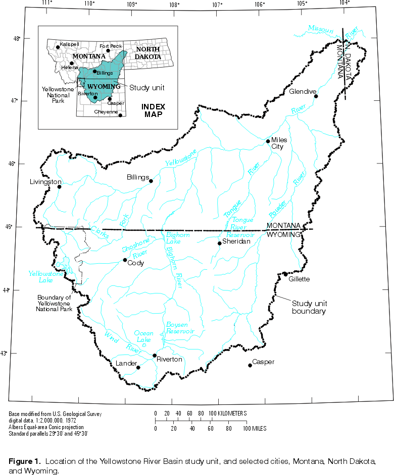
| Figure 1. Location of Yellowstone River Basin study unit
and selected cities. (Click on image for a larger version, 86 kb.) |
U.S. Geological Survey (USGS) to commence full-scale implementation of the National Water-Quality Assessment (NAWQA) Program. Goals of the program include the identification, description, and explanation of major natural and anthropogenic factors that influence water-quality conditions (Gilliom and others, 1995). Important components of the NAWQA Program are investigations of more than 50 major river basins and aquifers, called study units. Water-quality conditions measured at sites in these study units may be misinterpreted unless spatial patterns and environmental characteristics of associated drainages or flow-path areas are understood.
|
| Figure 1. Location of Yellowstone River Basin study unit
and selected cities. (Click on image for a larger version, 86 kb.) |
The Yellowstone River Basin (YRB) was among the set of 13 NAWQA study-unit investigations begun in 1997. The YRB study unit (fig. 1) consists of the entire 182,000 km2 area drained by the Yellowstone River and its tributaries, including the Wind/Bighorn, Powder, Tongue, and Clarks Fork Yellowstone Rivers. The Yellowstone River is the largest tributary of the Missouri River (Missouri Basin Inter-Agency Committee, 1969), and the mean annual discharge (361 m3/s) of the Yellowstone at its confluence with the Missouri in western North Dakota represents about 55 percent of their combined discharge (Shields and others, 1997).
The purpose of the study-unit investigation is to increase the scientific understanding of surface- and ground-water quality and the factors that influence water quality in the YRB. Important water-quality issues in the YRB generally are related to effects of land and water management practices, but some are related to natural factors. For example, sedimentation problems in streams and reservoirs in parts of the YRB are likely a result of naturally erodible soils and natural processes such as post-wildfire landslides and debris flows, as well as human land-use activities that remove vegetation, disturb soils, and steepen or overload slopes. Other major water-quality issues include trace elements, toxic compounds, and salinity (Miller and Quinn, 1997).
This report describes the environmental settings of the YRB, including natural and anthropogenic factors believed to influence water-quality conditions. Specifically, the report provides historical and baseline information for the topical studies to be undertaken as part of the NAWQA study-unit investigation of the YRB. An initial stratification (subdivision into areas having greater homogeneity than the whole YRB) of the study unit based on its environmental settings also is presented.
Early explorers of the YRB include Larocque in 1805, Clark in 1806, Colter in 1807-08, Drouillard in 1808, Henry in 1809, Hunt in 1811, Wyeth in 1833, and Raynolds and Maynadier in 1859-60 (U.S. Department of the Interior, 1965; Missouri Basin Inter-Agency Committee, 1969). The U.S. Army sent exploratory expeditions into the YRB, beginning with the 1856 expedition led by Lt. G.K. Warren, accompanied by geologist F.V. Hayden. Hayden mapped the general geology of the Wind River Basin in 1859-60 and the Yellowstone-Teton area in 1868. The Washburn-Doane expedition of 1870 ascended the Yellowstone River and received official credit for the "discovery" of what became Yellowstone National Park. Also in 1870, the Yale Scientific Expedition, led by O.C. Marsh, explored the Bighorn Basin. The U.S. Geological and Geographical Survey of the Territories began in 1871, under the direction of Hayden, and produced impressive documentation of the geologic and scenic wonders of the Yellowstone Plateau, due in large part to the photography by W.H. Jackson and paintings by Thomas Moran.
Settlement and development of the YRB followed the period of exploration. Numerous studies have been conducted in local areas and of individual resources or environmental factors within this vast area. Selected previous studies that were broad in geographic extent and that examined multiple geographic or environmental factors are the topic of the remainder of this section.
A general reconnaissance of the northern Great Plains was made by the USGS in 1924 to classify the public domain into three principal land-suitability categories: land that would be best suited to production under irrigation, by dry-farming methods, or as grazing land (Aldous and Deeds, 1929). That study included part of the YRB east of the Rocky Mountains and north of 43°N latitude, and described the physiography, soils, and vegetation.
The U.S. Department of the Interior's Missouri River Project was a basin development program active from 1945-65 that produced separate studies of seven subbasins that together compose the YRB (for examples, the reader is referred to U.S. Department of the Interior, 1949; 1965). The purpose of these studies was to promote the use and management of the public lands in the best interests of the public, consistent with proper conservation practices (U.S. Department of the Interior, 1965). A recommendation resulting from that program was the sale of a large part of the vacant, unreserved public domain that would contribute more to the local economy in private ownership (U.S. Department of the Interior, 1965).
During 1964-69, a comprehensive study of the Missouri River Basin was conducted to guide long-range planning for multipurpose development of water and related land resources during 1970-2020 (Missouri Basin Inter-Agency Committee, 1969). The recommendations made in the final report included the following: (1) construction of 78 reservoirs to provide 2.6 million m3 of additional storage; (2) development of 2,500 km2 of land for irrigation; (3) protecting 179 km of stream banks against erosion; (4) designating 507 km of scenic rivers; and (5) acquisition of 186 km2 of land for wildlife management (Missouri Basin Inter-Agency Committee, 1969). The planners foresaw conflicts between environmental values related to scenic beauty and preservation of wild streams and economic-development values related to an extensive system of reservoirs and irrigation projects. Given the surface-water emphasis of the interagency study, a subsequent study (Taylor, 1978) of the Missouri River Basin was done to describe its ground-water resources and indicate areas where information was lacking.
During the late 1960s and through the 1970s, a series of water-resources assessments were conducted in several moderately large study areas included in the YRB (for examples, the reader is referred to Miller, 1979; 1981; Taylor, 1968). The Yellowstone Impact Study, begun in 1974 by the Montana Department of Natural Resources and Conservation, evaluated potential physical, biological, and water use impacts of water development on the middle and lower sections of the Yellowstone River Basin in Montana (Newell, 1977). Due to the importance of ground water for domestic and stock consumption, studies of several areas of the Powder River Basin emphasized the major aquifers in those areas. Several ground-water studies from this period examined the potential hydrologic effects of the anticipated development of coal resources in the Powder River Basin (Slagle and others, 1985; Van Voast and others, 1978; Van Voast and Thompson, 1982). A notable large-area study examining a broader scope of effects of coal development was the Northern Great Plains Resource Program (1974)
Following enactment of the Surface Mining Control and Reclamation Act of 1977 (PL 95-87), requiring the assessment of hydrologic impacts prior to issuance of mining permits, a series of reports summarizing the hydrology of coal provinces were prepared by the USGS. The drainages of the Clarks Fork Yellowstone River, Pryor Creek, and smaller tributaries to the Yellowstone River in its westernmost Great Plains reach were characterized by Slagle and others (1986). Peterson and others (1987) described the resources of much of the area drained by the Bighorn-Wind and Shoshone Rivers upstream of Bighorn Lake. Slagle and others (1983) characterized the drainages of the Tongue River, Rosebud Creek, and smaller tributaries to the middle reach of the Yellowstone River. Lowry and others (1986) described the hydrology and setting of the Powder River Basin. Drainages of the lower reach of the Yellowstone River were characterized by Slagle and others (1984).
About the northeastern half of the YRB was included in the study area of the USGS' Northern Great Plains Regional Aquifer-System Analysis (RASA) that began in 1981. The objectives of that study were to describe the regional trends of ground-water chemistry, to determine the mechanisms controlling the water chemistry, and to identify flow directions and areas of recharge (Busby and others, 1995). The study focused on Lower Cretaceous through Paleozoic aquifers.
During 1986-90, the USGS conducted studies of the water-quality of the Powder River. The objectives were to (1) determine temporal trends in selected water properties and chemical constituents (Cary, 1989; 1991), and (2) develop a water-quality model of the river to evaluate water-management alternatives (Lindner-Lunsford and others, 1992). Also during the late 1980s, an atlas of the water resources and water hazards of Wyoming was compiled (Ostresh and others, 1990).
Return to Environmental Setting of the Yellowstone River Basin, WRIR 98-4269