 |
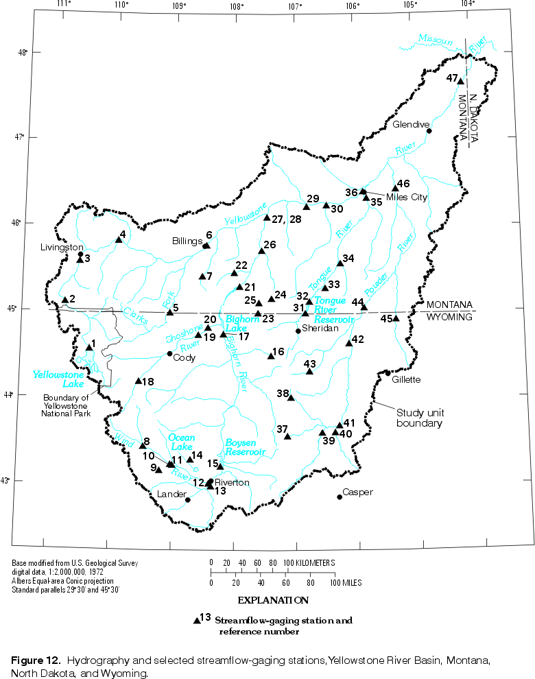
| Figure 12. Hydrography and selected streamflow-gaging
stations, Yellowstone River Basin. (Click on image for a larger version, 79 kb) |
The surface-water hydrology of the Yellowstone River Basin is characterized by the physiography of the basin and the flow and quality of its streams. Physiographic characteristics of the basin are important influences on the hydrology. Streamflows are characterized according to the origin of the streams as well as by the time of year. Characteristics of general stream-quality indicators illustrate the overall condition and variability in the quality of the basin surface-water.
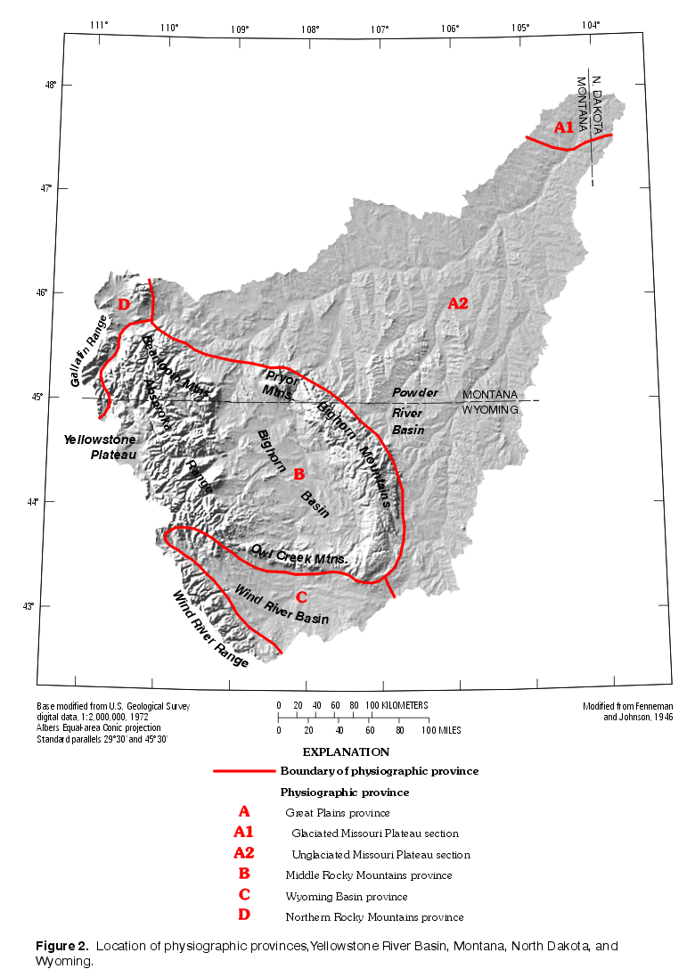
The diverse physiography of the YRB is an important factor in determining the surface-water hydrology. From its headwaters at the Continental Divide in northwestern Wyoming, the Yellowstone River flows out of the mountains and across the plains of south-central and eastern Montana to the confluence with the Missouri River in western North Dakota (fig. 12). The mainstem flows through the northwestern and northern parts of the study area only, resulting in an asymmetric drainage network. Most inflow to the mainstem is from the south from four major tributary basins: the Clarks Fork Yellowstone, Wind/Bighorn, Tongue, and Powder Rivers. The higher elevations of the Beartooth Mountains, Wind River Range, Absaroka Range, and Bighorn Mountains are the headwaters of most of the perennial streamflow in the basin (Wahl, 1970). Tributary to the major streams, as well as the mainstem, are many streams that originate in the lower elevations of the basins and plains areas.
|
| Figure 12. Hydrography and selected streamflow-gaging
stations, Yellowstone River Basin. (Click on image for a larger version, 79 kb) |
Basin relief is large; headwaters elevations exceed 3,900 m above sea level for streams originating in the mountains, while the mouth of the mainstem Yellowstone River is only 564 m above sea level. The mainstem is more than 1,130 km long. The combination of large relief in the mountainous areas and long stream lengths across the basins and plains results in a large range in slopes for the major tributaries. Grading downstream from steep to relatively flat, channel slope of the mainstem ranges from more than 8 m/km in the upper reaches to about 0.6 m/km for the lower 400 km of the river. Mean depth and width increase with distance downstream for many streams in the basin. Leopold and Maddock (1953) demonstrated that for a discharge of given frequency (or an approximation thereof, such as mean annual discharge), those channel dimensions can be approximated as power functions of that discharge at sites along the Powder and Wind/Bighorn River Basins and downstream along the mainstem Yellowstone River.
Streamflow characteristics in the YRB (table 1) vary by geographic location, time of year, and degree of human influence. For most streams in the basin with little or no flow modifications, streamflow characteristics can be described by annual streamflow and flow duration at representative locations. For streams where human activities have modified the natural drainage, regulation, diversion, and return flows affect streamflow characteristics to varying degrees. Variations in geography and weather cause severe floods and droughts in the basin. Flows resulting from these extreme hydrologic events affect water quality.
Table 1. Basin characteristics and annual streamflow statistics at selected sites, Yellowstone River Basin
[Number of years in analyses refers to complete years used in computation of annual statistics; km2, square kilometer; m3/sec, cubic meter per second; ft3/sec; cubic feet per second; Yellowstone River mainstem atations shown in light yellow; YNP; Yellowstone National Park; MT, Montana; WY, Wyoming; NR, not relevant]
|
Reference number (fig. 12) |
Station number |
Streamflow-gaging station |
Elevation |
Drainage area |
Annual streamflow |
|||
|---|---|---|---|---|---|---|---|---|
|
Mean annual |
Mean |
Coefficient of variation |
Number of years in analyses |
|||||
|
1 |
06186500 |
Yellowstone River at Yellowstone Lake Outlet, YNP |
2,356 |
2,606 |
37.6 |
1,328 |
0.23 |
67 |
|
2 |
06191500 |
Yellowstone River at Corwin Springs, MT |
1,548 |
6,794 |
87.9 |
3,104 |
.21 |
90 |
|
3 |
06192500 |
Yellowstone River near Livingston, MT |
1,385 |
9,197 |
105 |
3,731 |
.19 |
71 |
|
4 |
06200000 |
Boulder River at Big Timber, MT |
1,237 |
1,350 |
16.3 |
575 |
.24 |
47 |
|
5 |
06207500 |
Clarks Fork Yellowstone River near Belfry, MT |
1,215 |
2,989 |
26.5 |
934 |
.22 |
75 |
|
6 |
06214500 |
Yellowstone River at Billings, MT |
939 |
30,549 |
198 |
6,988 |
.23 |
68 |
|
7 |
06216000 |
Pryor Creek at Pryor, MT |
1,221 |
303 |
.973 |
34.4 |
.35 |
29 |
|
8 |
06220500 |
East Fork Wind River near Dubois, WY |
1,960 |
1,110 |
6.94 |
245 |
.30 |
28 |
|
9 |
06224000 |
Bull Lake Creek above Bull Lake, WY |
1,790 |
484 |
8.29 |
293 |
.20 |
42 |
|
10 |
06225000 |
Bull Lake Creek near Lenore, WY |
1,723 |
552 |
7.76 |
274 |
.25 |
75 |
|
11 |
06225500 |
Wind River near Crowheart, WY |
1,718 |
4,898 |
34.0 |
1,201 |
.21 |
51 |
|
12 |
06228000 |
Wind River at Riverton, WY |
1,494 |
5,980 |
23.1 |
815 |
.44 |
81 |
|
13 |
06235500 |
Little Wind River near Riverton, WY |
1,494 |
4,931 |
16.3 |
575 |
.19 |
55 |
|
14 |
06244500 |
Fivemile Creek above Wyoming Canal, near Pavillion, WY |
1,680 |
306 |
.0937 |
3.30 |
1.57 |
34 |
|
15 |
06253000 |
Fivemile Creek near Shoshoni, WY |
1,450 |
1,080 |
4.50 |
159 |
.21 |
44 |
|
16 |
06278300 |
Shell Creek above Shell Reservoir, WY |
2,760 |
59.8 |
.988 |
34.9 |
.21 |
40 |
|
17 |
06279500 |
Bighorn River at Kane, WY |
1,120 |
40,831 |
62.9 |
2,222 |
.27 |
67 |
|
18 |
06280300 |
South Fork Shoshone River near Valley, WY |
1,890 |
769 |
11.6 |
411 |
.22 |
39 |
|
19 |
06284500 |
Bitter Creek near Garland, WY |
1,240 |
208 |
4.05 |
143 |
.11 |
25 |
|
20 |
06285100 |
Shoshone River near Lovell, WY |
1,170 |
6,090 |
25.6 |
903 |
.34 |
30 |
|
21 |
06287000 |
Bighorn River near St. Xavier, MT |
963 |
50,938 |
98.8 |
3,490 |
.24 |
62 |
|
22 |
06288200 |
Beauvais Creek near St. Xavier, MT |
1,020 |
259 |
.668 |
23.6 |
.51 |
10 |
|
23 |
06289000 |
Little Bighorn River at State Line, near Wyola, MT |
1,330 |
500 |
4.25 |
150 |
.24 |
56 |
|
24 |
06290500 |
Little Bighorn River below Pass Creek, near Wyola, MT |
1,100 |
1,110 |
5.89 |
208 |
.32 |
55 |
|
25 |
06291500 |
Lodge Grass Creek above Willow Creek Diversion, near Wyola, MT |
1,270 |
209 |
1.37 |
48.4 |
.32 |
49 |
|
26 |
06294000 |
Little Bighorn River near Hardin, MT |
879 |
3,351 |
8.23 |
290 |
.44 |
43 |
|
27 |
06294500 |
Bighorn River above Tullock Creek, near Bighorn, MT |
823 |
58,052 |
108 |
3,810 |
.25 |
51 |
|
28 |
06294700 |
Bighorn River at Bighorn, MT |
NR |
59,272 |
a |
a |
NR |
NR |
|
29 |
06294995 |
Armells Creek near Forsyth, MT |
780 |
958 |
.163 |
5.75 |
1.04 |
18 |
|
30 |
06296003 |
Rosebud Creek at mouth, near Rosebud, MT |
756 |
3,372 |
.892 |
31.5 |
.98 |
22 |
|
31 |
06306300 |
Tongue River at State Line, near Decker, MT |
1,045 |
3,825 |
13.1 |
462 |
.33 |
36 |
|
32 |
06307500 |
Tongue River at Tongue River Dam, near Decker, MT |
1,019 |
4,580 |
12.6 |
446 |
.33 |
57 |
|
33 |
06307600 |
Hanging Women Creek near Birney, MT |
960 |
1,220 |
.0997 |
3.52 |
.97 |
21 |
|
34 |
06307740 |
Otter Creek at Ashland, MT |
889 |
1,830 |
.134 |
4.72 |
.91 |
21 |
|
35 |
06308500 |
Tongue River at Miles City, MT |
719 |
13,980 |
11.9 |
421 |
.44 |
53 |
|
36 |
06309000 |
Yellowstone River at Miles City, MT |
711 |
124,980 |
324 |
11,440 |
.23 |
69 |
|
37 |
06309200 |
Middle Fork Powder River near Barnum, WY |
2,200 |
117 |
.849 |
30.0 |
.35 |
35 |
|
38 |
06311000 |
North Fork Powder River near Hazelton, WY |
2,490 |
63.5 |
.423 |
14.9 |
.30 |
50 |
|
39 |
06313000 |
South Fork Powder River near Kaycee, WY |
1,400 |
2,980b |
1.03 |
36.5 |
.55 |
23 |
|
40 |
06313400 |
Salt Creek near Sussex, WY |
1,370 |
1,990 |
1.28 |
45.1 |
1.21 |
16 |
|
41 |
06313500 |
Powder River at Sussex, WY |
1,331 |
8,000 |
5.76 |
204 |
.48 |
25 |
|
42 |
06317000 |
Powder River at Arvada, WY |
1,100 |
15,700 |
7.85 |
277 |
.46 |
65 |
|
43 |
06318500 |
Clear Creek near Buffalo, WY |
1,580 |
311 |
1.75 |
61.9 |
.39 |
64 |
|
44 |
06324500 |
Powder River at Moorhead, MT |
1,016 |
20,950 |
12.8 |
452 |
.42 |
65 |
|
45 |
06324970 |
Little Powder River above Dry Creek, near Weston, WY |
1,040 |
3,199 |
.622 |
22.0 |
1.22 |
24 |
|
46 |
06326500 |
Powder River near Locate, MT |
727 |
34,160 |
16.6 |
586 |
.51 |
58 |
|
47 |
06329500 |
Yellowstone River near Sidney, MT |
573 |
178,980 |
361 |
12,750 |
.27 |
84 |
aFlow equivalent to USGS 06294500 (site 27).
bEstimated.
Annual streamflow can be characterized by measures of central tendency, such as the mean, and of variability, such as the coefficient of variation (COV), defined as the standard deviation divided by the mean. Most of the annual streamflow from the YRB originates in the mountainous areas of the upper Yellowstone River and the Clarks Fork Yellowstone River and Wind/Bighorn River Basins. Representing about half of the study unit's total drainage area, the combined mean annual flows from the upper Yellowstone, Clarks Fork Yellowstone, and Wind/Bighorn Rivers equal about 86 percent of the mean annual flow at the mouth of the basin (table 2). Runoff amounts from the basins and plains areas are lower than those from the mountainous areas. Annual runoff in the YRB ranges from less than 0.25 cm (0.1 in.) in the lower-elevation parts of the Wind/Bighorn River Basin to more than 75 cm (30 in.) in the higher elevations of the Wind River Range and Beartooth Mountains (U.S. Geological Survey, 1970a). Mean annual runoff from the Powder River Basin is less than 2 cm (0.8 in.), even though the drainage area for this major tributary is about 20 percent of the YRB study unit (table 2).
Table 2. Mean annual runoff for major tributaries and the mainstem as measured at selected sites, Yellowstone River Basin (Modified from Shields and others, 1997)
[km2, square kilometer; m3/sec, cubic meter per second; ft3/s, cubic feet per second; cm, centimeter; in., inches]
|
Site |
|
Mean annual flow |
Mean annual runoff |
Period represented |
||
|---|---|---|---|---|---|---|
|
Reference number (fig. 12) |
Station numbera |
Tributary and/or part of mainstem represented by station |
Drainage area |
|||
|
6 |
06214500 |
Yellowstone headwaters/Upper Yellowstone/Clarks Fork Yellowstone River |
30,549 |
198 |
20.4 |
1929-96 |
|
27 |
06294500 |
Wind/Bighorn River |
58,052 |
111 |
6.03 |
1967-96c |
|
35 |
06308500 |
Tongue River |
13,980 |
11.9 |
2.68 |
1938-96 |
|
46 |
06326500 |
Powder River |
34,160 |
16.6 |
1.51 |
1939-96 |
|
47 |
06329500 |
Yellowstone River Basin |
178,980 |
359 |
6.33 |
1967-96c |
aFor tributaries, station represents site closest to the tributary mouth.
bDrainage area at site is less than total area of river basin.
cPeriod after completion of Yellowtail Dam (Bighorn Lake).
Streams in the mountainous areas of the YRB generally are perennial (Wahl, 1970; Lowham, 1988). Most of the flow in mountain streams is from snowmelt runoff. Annual streamflows in the mountainous areas are dominated by a single snowmelt peak of moderate duration during late spring/early summer with low variability in daily mean discharge throughout the year (fig. 13 A and F). Variabilities in annual flows in streams in the mountainous areas of the basin are generally small. Relative to the intense localized convective rainstorms of the basins and plains areas, mountain snow accumulations are less variable in aerial extent and between years. The coefficients of variation in annual discharge at sites 1-4, 9, 16, and 18 (table 1) are about 0.2. Coefficients of variation are slightly larger (0.3 to 0.4) at sites on the northern and eastern flanks of the Bighorn Mountains (sites 7, 24, 25, 37, and 38).
 |
| Figure 13. Statistical summary of daily mean streamflow for period of record at selected streamflow-gaging stations, Yellowstone River Basin. (Click on image for a larger version, 112 kb) |
Most streams originating in the basins or plains areas of the YRB are ephemeral, flowing only as a result of local snowmelt or intense rainstorms (Wahl, 1970; Omang, 1992). Intense localized convective rainstorms can produce most of the total flow for any given year in these watersheds. The distribution and occurrence of these events vary between years (Lowham, 1988, p. 18). Because of the localized extent and annual variability of these storms, the resulting flows in any given watershed are variable between years. Annual flows of streams originating in the basin or plains areas often consist of multiple peaks: a lowland snowmelt peak of moderate duration occurring late winter/early spring and several rainstorm peaks of short duration occurring late spring through late summer (fig. 13 B).
Several streams that originate in the basins and plains areas of the YRB are characterized by large variability in annual streamflow. Coefficients of variation in annual mean discharge at representative sites are about 1.0 or larger (sites 29, 30, 33, 34, 40, and 45) (table 1).
Larger streams with headwaters in mountainous areas of the YRB that flow across the basins and plains exhibit a combination of annual streamflow characteristics of mountain, basin, and plains streams. Annual flows consist of a lowland snowmelt peak during late winter/early spring followed by a peak from the mountain snowmelt during late spring/early summer with several short to moderate duration rainstorm peaks superimposed on the snowmelt peak and throughout the remainder of the summer (fig. 13 C and G). Coefficients of variation are moderate at representative sites on the Tongue, Powder, and Yellowstone Rivers, ranging from more than 0.2 to about 0.5 (sites 35, 36, 41, 42, 44, 46, and 47) (table 1).
Flows in some streams in the YRB are affected by various flow modifications. In some watersheds where irrigated agriculture is a major land use, most of the streamflow results from agricultural return flows and sustained base flows. Formerly intermittent or periodically ephemeral streams often flow perennially upon the development of irrigation (Colby and others, 1956; Plafcan and others, 1993). Annual flows generally are uniform throughout the irrigation season, with a gradual decrease to a sustained base flow following the end of the growing season (fig. 13 D). Relative to the event-based annual flows in undeveloped ephemeral drainages, these flows are generally less variable between years. Variabilities in annual flows for two representative watersheds in the basin are very low; coefficient of variation at site 15 is 0.21 and at 19 is 0.11 (table 1). Streamflow characteristics of perennial streams below major diversions or reservoirs sometimes exhibit large variations during high flows (fig. 13 E). Coefficients of variations at representative sites in the Wind/Bighorn River Basins are moderate (sites 12 and 20) (table 1).
Streamflow duration is the time over which a given discharge is recorded at a site. For all discharges at a site during the period of record or interest, flow durations can be summarized graphically as a curve derived by plotting each discharge with the cumulative exceedance probability (in percent) for that discharge.
The resulting flow-duration curve shows the percentage of time during which a range of flows were equaled or exceeded during the period of interest without consideration for the chronology of the individual flows. Thus, the curve is a graphical representation of the variability of streamflow at a site over an entire period of interest. The shape of the flow-duration curve is a function of the basin hydrological and physical characteristics. If flow-duration curves are based on representative data, the curves are useful for predicting flow distributions for water-quality assessments (Searcy, 1959).
Most of the flow in perennial streams that originate in the mountainous areas of the YRB is from snowmelt (see previous section on Annual Streamflow). Site 9 (fig. 12) is representative of streams originating in the mountainous areas of the basin. The flow-duration curve for site 9 (fig. 14 A) is generally flat for high and low flows, illustrating the small variability in flows typical of perennial streams. The flatness of the curve for both small and large exceedances is typical of a perennial stream with consistent high flows and sustained low flows from snowmelt.
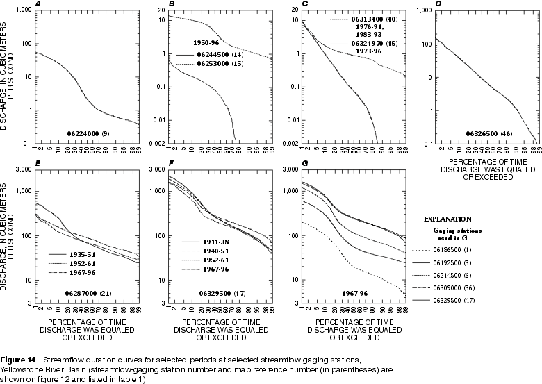 |
| Figure 14. Streamflow duration curves for selected periods at selected streamflow-gaging stations, Yellowstone River Basin. (Click on image for a larger version, 45 kb) |
Ephemeral streams that originate in the basins or plains areas of the YRB flow only as a result of snowmelt or rainstorms. As described previously (see Annual Streamflow section), these snowmelt and rainstorm events vary greatly in intensity, duration, frequency, and extent. Because flows in the basins and plains areas are in response to these discrete events, the variability in streamflows depends on the variability of the events. Similarly, periods of no flow are common; low or base flows from surface- or ground-water storage, if present, generally do not persist throughout the year nor throughout the stream reaches (Omang, 1983; Parrett, 1983; Rankl and Armentrout, 1986). Site 45 (fig. 12) is representative of streams, with few effects from flow modifications, that originate in the basin and plains areas of the YRB. The flow-duration curve for site 45 (fig. 14 C) is generally steep throughout most of the range of flows, illustrating the large variability in flows typical of ephemeral streams. The steepness of the curve for large exceedances also is typical of ephemeral streams, illustrating the lack of sustained low or base flows.
Streams that originate in the mountains and flow across the basins and plains areas generally are perennial. Larger drainage areas, snowmelt runoff, and ground-water sources minimize variability in high and low flows (Omang, 1986). The flatness of flow-duration curves for sites 6, 36, and 47 (fig. 14 G) on the mainstem Yellowstone River illustrates the low variabilities in flows in these types of streams. Some streams, however, lose flow in the plains areas of the basin, resulting in intermittent flow some years. Ringen and Daddow (1990) attributed net losses in streamflow along the Powder River during 1978-80 at sites 42 and 44 (fig. 12) to seepage and evapotranspiration. Such losses result in more variability in base flows, a condition illustrated by the moderately steep flow-duration curve for site 46 on the Powder River (fig. 14 D).
Flow modifications have affected flow durations of some streams in the YRB. In some watersheds, land-use practices augment natural flows to sites downstream. Inflows from irrigation drainage below site 14 have resulted in lower streamflow variability and sustained base flows at site 15 (fig. 12). The resulting flow-duration curve is similar to that of a perennial stream (fig. 14 B). Ground water is pumped and discharged as surface water during the production of oil and gas in some watersheds. Such produced water is discharged upstream from site 40, resulting in perennial flow in what was once an ephemeral stream (Lindner-Lunsford and others, 1992). The resulting flow-duration curve is flat for large exceedances, illustrating the sustained base-flows (fig. 14 C, site 40). Flows are completely regulated by reservoirs in some watersheds in the YRB. Variations in flow are low at site 21 (fig. 12) downstream of Bighorn Lake (Yellowtail Dam). The flow-duration curves for the periods after the completion of Boysen Reservoir (1952-61 and 1967-96) are flat throughout the range of all flows, illustrating that the regulated flows are sustained for most exceedances (fig. 14 E, site 21).
The composite effects of flow modifications in the YRB decrease streamflow variability. At the mouth of the basin, the decrease in streamflow variability over time is illustrated in flow-duration curves for site 47 (fig. 14 F). The curves represent periods between completion of major reservoirs in the basin. The cumulative effect of sustained regulated flows from reservoir releases results in the flattening of the flow-duration curve, indicating less variability in streamflows. In addition to flow modifications, climate changes influence the overall variability in streamflows in the basin. The period 1952-61 represents the time after which operation of Boysen Reservoir began and before which construction of Yellowtail Dam (Bighorn Lake) was completed (fig. 14 E and F). Overlapping this period, the drought of 1948-62 had severe effects on most of Wyoming and Montana (see following section).
Diverse geographic features and variable moisture systems combine to cause severe floods and droughts in the YRB (Druse, 1991; Merritt and others, 1991). Floods and droughts are extreme hydrologic events that can degrade ambient surface-water quality. The highest constituent loads from nonpoint sources, such as overland flow, occur during flooding (Novotny and Olem, 1994). Floodwaters can scour gravels and deposit sediment, processes that are detrimental to spawning beds for some fish species (Merritt and others, 1991). Decreased flows during drought periods lessen the diluting effect of streams on inflows (including surface and ground water), potentially resulting in increased concentrations of dissolved solids. Lower dissolved-oxygen levels and higher stream temperatures also may occur during extended periods of low flows, adversely affecting aquatic life (Matthai, 1979).
Flooding in the YRB can occur as a result of snowmelt, widespread rainfall, or intense thunderstorms. In mountainous areas of the basin, most flooding occurs during spring and early summer from rapid snowmelt. Flooding in the basins and plains areas occurs during winter and early spring from lowland snowmelt, during spring from large regional rainstorms, and during summer and fall from intense localized thunderstorms. High antecedent soil moisture, frozen ground, and rainfall on melting snowpacks contribute to the most severe floods (Craig and Rankl, 1978; Lowry and others, 1986; Lowham, 1988; Druse, 1991; Omang, 1992; Holnbeck and Parrett, 1996).
Flooding occurred during 1923 in parts of the YRB during July 23-25 and again during September 27-30 as a result of widespread thunderstorms and rainfall. Referred to by long-term residents as "the big floods of 1923," these were the most severe floods since 1880 and were during the period 1918-27 in which more large floods occurred in Wyoming than any other decade (Cooley, 1990). Peak flow recurrence intervals exceeded 100 years at several USGS stations in the Wind, Bighorn, and Powder River Basins (Druse, 1991). The 1923 peak discharge at site 42 (Powder River at Arvada, Wyoming; fig. 12) of 2,830 m3/sec (Smalley and others, 1997) is twice the next largest peak of record (period of record 1919-96).
Severe flooding occurred during May 1978 in southeastern and south-central Montana and northeastern Wyoming (Merritt and others, 1991). Watersheds affected in the basin included the Yellowstone River from near Billings, Montana, to Miles City, Montana; the Bighorn, Tongue, and Powder Rivers; and many smaller tributary watersheds (Parrett and others, 1984). Widespread rain on saturated soils combined with bankfull snowmelt runoff conditions in most streams to cause the flooding. Flood recurrence intervals exceeded 50 years for most of the affected area (Merritt and others, 1991). Sediment transport is often very high during floods. Record maximum daily suspended-sediment loads at four sites were measured on the Powder River (table 3). Other major floods occurred in the YRB during 1918, 1962, 1963, and 1981 (Druse, 1991; Merritt and others, 1991).
Table 3. Maximum daily suspended-sediment discharge, flood of May 1978, Powder River, Wyoming and Montana (From Parrett and others, 1984)
[m3/s, cubic meters per second, ft3/s, cubic feet per second]
|
Reference number |
Powder River streamflow-gaging station |
Date |
Maximum flood discharge |
Suspended-sediment
discharge |
|
|---|---|---|---|---|---|
|
Number |
Location |
||||
|
42 |
06317000 |
at Arvada, Wyoming |
May 20, 1978 |
a920 (32,500) |
2,550,000 |
|
44 |
06324500 |
at Moorhead, Montana |
May 20, 1978 |
935 (33,000) |
2,020,000 |
|
b |
06324710 |
at Broadus, Montana |
May 21, 1978 |
850 (30,000) |
1,420,000 |
|
46 |
06326500 |
near Locate, Montana |
cMay 22, 1978 |
776 (27,400) |
670,000 |
aApproximate measurement.
bLocation not shown on figure 12.
cMaximum flood discharge occurred on May 23.
Severe droughts of several-years duration have occurred in the YRB. Droughts with recurrence intervals greater than 25 years occurred during the periods 1929-42 and 1948-62 over most of Wyoming and Montana (Druse, 1991; Merritt and others, 1991), including nearly all of the YRB. Such regional drought conditions are common in the upper parts of the Missouri River Basin (Matthai, 1979). Droughts with recurrence intervals of 10 to 25 years occurred in the YRB between 1976 and 1982. Recent data for representative streamflow-gaging stations in the basin used in previous drought analyses by Druse (1991) and Merritt and others (1991) indicate lower than normal flows from about 1987 to about 1994 (table 4).
Table 4. Annual departure from mean annual discharge at selected streamflow-gaging stations, Yellowstone River Basin, water years 1987-96 (Modified from U.S. Geological Survey, 1997c)
[06191500 (2), station number and (reference number, fig. 12); --, no data]
|
Water year |
Annual departure from mean annual discharge, in percent |
|||||
|---|---|---|---|---|---|---|
|
06191500 |
06214500 |
06225500 |
06317000 |
06318500 |
06324500 |
|
|
1987 |
-32.5 |
-30.3 |
-11.4 |
21.7 |
-2.6 |
7.2 |
|
1988 |
-36.4 |
-36.4 |
-31.2 |
-43.8 |
-33.5 |
-40.2 |
|
1989 |
-9.8 |
-11.1 |
-22.1 |
-53.5 |
-22.5 |
-64.7 |
|
1990 |
-3.6 |
-10.3 |
-14.2 |
-31.6 |
6.3 |
-22.0 |
|
1991 |
3.0 |
4.2 |
10.2 |
-12.9 |
31.9 |
8.4 |
|
1992 |
-11.1 |
-9.5 |
-32.9 |
-39.5 |
31.7 |
-23.0 |
|
1993 |
11.9 |
9.0 |
-16.3 |
36.3 |
-- |
29.1 |
|
1994 |
-22.6 |
-30.3 |
-34.4 |
-34.1 |
-- |
-31.2 |
|
1995 |
6.9 |
12.6 |
4.7 |
130 |
-- |
75.9 |
|
1996 |
45.4 |
38.6 |
12.5 |
-8.8 |
-- |
2.1 |
The drought of 1977 affected most of the United States west of the Mississippi River (Matthai, 1979, fig. 2). In the YRB, the 1977 drought was part of the 1976-82 drought period; the most severely affected areas were the upper parts of the Wind and Yellowstone River watersheds (Druse, 1991; Merritt and others, 1991). Decreased streamflows during droughts can result in higher dissolved-solids concentrations. Median concentrations of total dissolved solids in samples collected during September through the following February of each year (that is, the period of year during which flows are lower) were significantly higher (Wilcoxon rank-sum test; p < 0.05) during the drought period 1976-82 than during non-drought years at sites 3 and 6 on the upper Yellowstone River (table 5). Dissolved-solids concentrations were higher during the 1976-82 drought than during non-drought periods at site 12 on the Wind River; however, the difference was not significant (table 5). Site 12 might not be representative of drought conditions in the upper parts of the Wind River watershed because of flow modifications upstream of the site.
Table 5. Statistics for total dissolved-solids concentration at selected sites, September-February, during non-drought and drought periods, upper Wind and Yellowstone Rivers, 1969-94
[n, number of analyses; mg/L, milligrams per liter; Y, yes; N, no]
|
Reference number |
Station number |
Non-drought periods |
1976-82 drought |
|||
|---|---|---|---|---|---|---|
|
n |
Median concentration |
n |
Median concentration |
Significance |
||
|
3 |
06192500 |
60 |
172 |
33 |
183 |
Y (p=0.0239) |
|
6 |
06214500 |
89 |
272 |
38 |
282 |
Y (p=0.0363) |
|
12 |
06228000 |
93 |
277 |
37 |
287 |
N (p=0.1752) |
aWilcoxin rank-sum test for significance; one-sided p value. Higher concentrations of total dissolved solids during the 1976-82 drought are significant at the 95-percent confidence level if p<0.05.
Concentrations of suspended sediments and dissolved solids in streams are indicators of water quality that are useful for characterizing the overall water-quality conditions of the YRB. Suspended-sediment and dissolved-solids concentrations are smaller in mountain streams overlying older rocks than in streams crossing the younger rocks of the basins and plains areas. Human activities that disturb the land contribute to suspended sediment and dissolved solids in surface water. Concentrations of suspended sediment and dissolved solids in streams in the basin vary with streamflow and season.
The concentration of sediment in suspension in a stream is an indicator of water quality. Suspended-
sediment data are useful in describing general basin water-quality conditions. Suspended sediment includes fragments of rock and soil that are transported in suspension by streams. Overland flow and channel scour are important erosional sources of suspended sediment in watersheds with little development; mass wasting contributes substantially to sediment loads in some systems (Colby and others, 1956). While much of the suspended sediment in streams is the result of natural factors, some human activities also contribute to sediment loads. Large suspended-sediment concentrations in streams tend to occur in range and agricultural land-use areas because of the high erodibility of soils in these areas (Smith and others, 1993).
Concentrations of suspended sediment in the YRB generally are lower in mountain streams than in streams draining the basins and plains areas. Most of the fluvial sediment in the basin is derived from the basins and plains areas (Hembree and others, 1952; Colby and others, 1956). About 30 percent of the annual sediment load at site 47 (fig. 12) is from the Powder River Basin, in spite of the fact it accounts for less than 5 percent of the annual streamflow (Knapton and Bahls, 1993). Statistical summaries of data from selected sites on the Wind and Powder Rivers illustrate the large concentrations of suspended sediment in the basins and plains streams (fig. 15). Suspended-sediment concentrations increase downstream in the Tongue River Basin (Litke and Knapton, 1983). A decrease in suspended-sediment concentrations between sites 42 and 46 (fig. 12) on the Powder River might be attributed to significant sediment deposition through this reach (fig. 15; also, Martinson and Meade, 1983; and, Ringen, 1986).
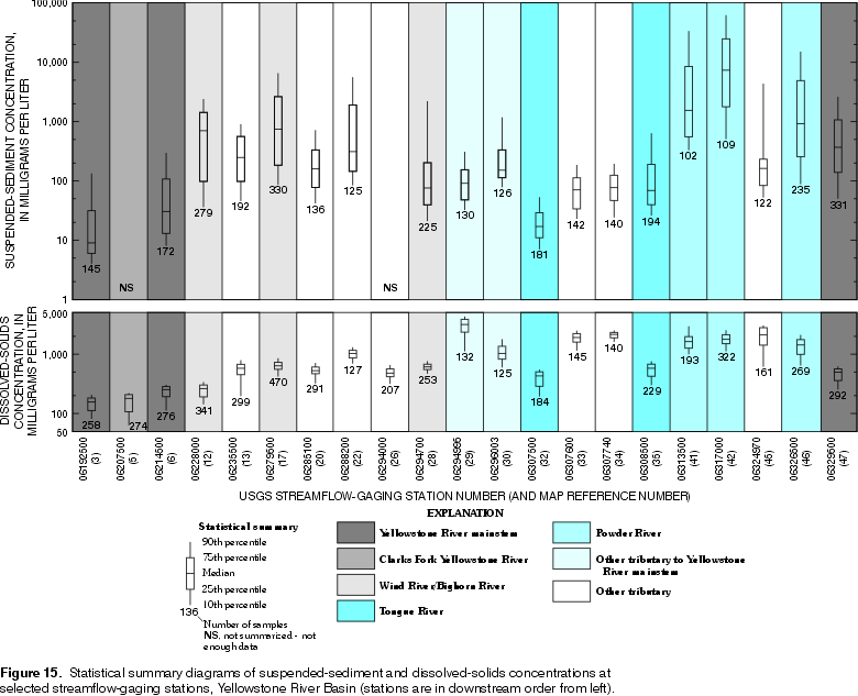 |
| Figure 15. Statistical summary diagrams of suspended-sediment and dissolved-solids concentrations at selected streamflow-gaging stations, Yellowstone River Basin. (Click on image for a larger version, 56 kb) |
Suspended-sediment concentrations in streams in the YRB generally are lower in watersheds where older rocks are exposed, such as resistant Precambrian and Paleozoic rocks. Concentrations of suspended sediment generally are larger in streams in contact with less resistant rocks of Mesozoic age and younger. Important sources of suspended sediment in the basins and plains watersheds include actively eroding gullies as well as erosion of the channel alluvium (Hembree and others, 1952; Colby and others, 1956).
Fluvial sediment is contributed by land-use activities in some watersheds in the YRB. Irrigation practices in the Clarks Fork Yellowstone River Basin, as well as natural factors, contribute a substantial part of the suspended sediment measured at site 6 (Knapton and Bahls, 1993). Prior to the completion of Boysen Reservoir, over half of the suspended-sediment load in the Bighorn River upstream of site 17 was contributed by Fivemile Creek (fig. 12, sites 14 and 15; see also Flow Duration section in this report). Colby and others (1956) determined 87 percent of the sediment load in Fivemile Creek originated within the irrigated area.
Suspended-sediment concentrations in alluvial streams with little or no flow modifications generally increase with increasing streamflow (Leopold and Maddock, 1953). In the YRB, the positive correlation between suspended-sediment concentrations and discharge is strong because of relatively high suspended-sediment concentrations and large seasonal and annual variability in streamflows. The largest concentrations in basins and plains streams usually occur during periods of direct runoff when erosion from overland flow and channel scour contribute the most sediment (Lambing, 1986). The correlation of suspended-sediment concentrations with discharge is generally poor in watersheds where natural flows are altered or where sources of sediment are limited.
Suspended-sediment concentration generally correlates well with discharge at selected sites in the YRB where suspended-sediment concentrations are relatively high. Suspended-sediment concentrations are the highest in the Powder River Basin; correlation coefficients range from about 0.7 to nearly 0.8 at selected sites (table 6; sites 41, 45, and 46). The good correlation between suspended-sediment concentration and discharge at site 12 (Spearman rank correlation coefficient = 0.84) might be more a function of sediment-flushing flows from a diversion dam upstream from the site rather than one of natural streamflow and suspended-sediment conditions.
Correlation of suspended-sediment concentration with discharge generally diminishes at selected sites in watersheds with streamflow modifications. Sites 17, 20, 28, and 35 are downstream from major reservoirs and irrigation diversions and returns. Suspended-sediment concentrations do not correlate well with discharge at site 28, where more than 90 percent of the mean annual flow is controlled by releases from Bighorn Lake (Yellowtail Dam). Decreased stream velocities at reservoir inlets result in the deposition of suspended sediment; consequently, suspended-sediment concentrations are limited in flows from reservoir outlets.
Dissolved-solids concentrations in surface waters are composite water-quality indicators that can be used to characterize the general water quality of a watershed. Total dissolved solids represents the sum of all dissolved constituents in a water sample. For watersheds without substantial development, the major dissolved constituents detected in streams result from the dissolution of minerals in soil and rock (Hem, 1985; Drever, 1988). Dissolved-solids concentrations are generally lower in forested watersheds and areas of higher precipitation; concentrations are generally higher in rangeland watersheds and regions of lower precipitation. Human activities that disturb the land, such as agriculture, mining, and other development, can increase dissolved solids in surface waters by exposing more minerals for dissolution (Smith and others, 1993). Concentrations of dissolved solids generally are inversely related to streamflow (Hem, 1985); thus, dissolved-solids concentrations vary with seasonal variations in streamflow.
Table 6. Correlation of suspended-sediment and dissolved-solids concentration with instantaneous discharge at selected sites, Yellowstone River Basin
[n, number of sample/discharge pairs; --, too few sample/discharge pairs: correlation not computed]
|
Reference number |
Station number |
Suspended-sediment concentration |
Dissolved-solids concentration |
||
|---|---|---|---|---|---|
|
n |
Spearman rank |
n |
Spearman rank |
||
|
3 |
06192500 |
141 |
0.62 |
147 |
-0.97 |
|
5 |
06207500 |
-- |
.-- |
124 |
-.86 |
|
6 |
06214500 |
170 |
.57 |
142 |
-.86 |
|
12 |
06228000 |
163 |
.84 |
131 |
-.57 |
|
13 |
06235500 |
92 |
.66 |
101 |
-.72 |
|
17 |
06279500 |
282 |
.56 |
137 |
-.81 |
|
20 |
06285100 |
114 |
.45 |
114 |
-.81 |
|
28 |
06294700 |
163 |
.28 |
149 |
-.26 |
|
35 |
06308500 |
156 |
.66 |
137 |
-.45 |
|
41 |
06313500 |
95 |
.79 |
170 |
-.58 |
|
42 |
06317000 |
-- |
.-- |
176 |
-.69 |
|
45 |
06324970 |
119 |
.71 |
161 |
-.50 |
|
46 |
06326500 |
196 |
.78 |
145 |
-.69 |
|
47 |
06329500 |
296 |
.65 |
186 |
-.53 |
aSee Helsel and Hirsch (1992) for description of Spearman rank correlation coefficient.
Concentrations of dissolved-solids in the YRB generally are lower in streams in mountainous areas than in those originating in the basins or plains areas (Knapton, 1983; Lambing, 1986; Larson, 1986; Peterson, 1987). Dissolved solids generally increase in streams flowing across the basins and plains areas of the YRB (Lowry, Smalley, and others, 1993; Peterson, 1993; Susong and others, 1993; Plafcan and Ogle, 1994). Statistical summaries of data from selected sites on streams in the Powder River Basin and tributaries to the Yellowstone and Tongue Rivers illustrate dissolved-solids concentrations are relatively high in streams originating in the plains areas of the YRB (fig. 15, sites 29, 30, 33, 34, and 45). Dissolved-solids increase downstream at representative sites on the Wind/Bighorn and Tongue Rivers, as well as on the mainstem Yellowstone River, which originate in the mountains and flow across the basins and plains areas (fig. 15, sites 12, 17, and 28; 32 and 35; and 3, 6, and 47, respectively).
Dissolved-solids concentrations in streams in the YRB are generally lower in watersheds overlying most older and some younger rocks. Dissolved solids are low in watersheds where Precambrian igneous and metamorphic rocks or more resistant Paleozoic sedimentary rocks predominate. Watersheds mostly underlain by Tertiary volcanic rocks also are low in dissolved solids. Concentrations of dissolved solids are generally higher in streams in contact with less resistant younger rocks. Dissolved solids are relatively high in watersheds draining mostly Mesozoic sandstones, siltstones, and shales, in particular, the Cody Shale and other Cretaceous marine shales (Hembree and others, 1952; Colby and others, 1956). Thermal springs along the upper Yellowstone and Bighorn Rivers are other geologic sources of dissolved solids (Knapton and Bahls, 1993; Peterson, 1993).
Various land-use practices contribute to dissolved solids in streams in some watersheds in the YRB. Irrigation practices contribute to dissolved solids in streams in the Clarks Fork Yellowstone, Wind/Bighorn, and Powder River Basins (Knapton and Bahls, 1993; Cary, 1991; Peterson and others, 1991; Lowry, Smalley, and others, 1993; Larson, 1986). Oil and gas development contributes to dissolved solids in the Wind/Bighorn (Lambing, 1986) and Powder River Basins. The Salt Creek watershed contributes approximately 25 to 30 percent of the dissolved solids at site 41 (fig. 12) on the Powder River; most of this load is from saline oil-production water (Lindner-Lunsford and other, 1992; Peterson, 1993).
Concentrations of dissolved solids generally are higher at lower discharges in most streams in the YRB. Ground water and other inflows contribute a substantial part of the lower flows in many streams of the basin and plains areas. Concentrations of dissolved solids in ground water, irrigation drainage, and wastewater discharge generally are higher than those in the receiving streams. Thus, the concentration of dissolved solids in streams increases during lower flows. Conversely, dissolved-solids concentrations are lower at higher discharges. Higher flows generally are the result of runoff from snowmelt or rainstorms, sources with very low concentrations of dissolved solids. Other inflows are diluted by the runoff, thereby decreasing the concentration of dissolved solids (Colby and others, 1956; Knapton, 1983; Lambing, 1986; Larson, 1986).
Correlation of dissolved-solids concentration with instantaneous discharge ranges from excellent to poor at selected sites in the YRB. Concentrations of dissolved solids correlate well with discharges at sites in the Clarks Fork Yellowstone and Wind/Bighorn Basins and on the upper mainstem Yellowstone River (table 6, sites 3, 5, 6, 13, 17, and 20). Dissolved-solids concentration does not correlate as well with discharge at site 12 (Spearman rank correlation coefficient = -0.57); upstream releases of very dilute reservoir waters contribute to a wide range of dissolved concentrations at lower flows (Colby and others, 1956, p. 123). Dissolved-solids concentrations do not correlate as well with discharges at selected sites in the Tongue and Powder River Basins (sites 35 and 45). Dissolved-solids concentrations increase initially during event-based flows in streams in the basins and plains areas from washoff of naturally occurring salts and larger ambient concentrations in tributary streams (Larson, 1986; Lindner-Lunsford and others, 1992; and, Lowry and others, 1993). Dissolved-solids concentrations do not correlate well with discharges at site 28 (Spearman rank correlation coefficient = -0.26) downstream from Bighorn Lake. Reservoirs function as holding and mixing basins in watersheds, affecting the quality of surface waters downstream (Hem, 1985).
Concentrations of dissolved solids vary by season at some sites in the YRB. Because dissolved-solids concentrations generally are related to streamflows and much of the variation in streamflows is seasonal, site-specific variation in dissolved-solids concentrations in the basin also is seasonal. Thus, dissolved-solids concentrations generally are higher during the fall and winter and lower during the spring and summer. Concentrations of dissolved solids are significantly higher (table 7) during the winter (January through March) than during any other season at site 26 (fig. 12). Dissolved-solids concentrations are lowest during the spring; however, the difference is only significant (table 7) when compared to the fall and winter months.
Table 7. Seasonal variability in total dissolved-solids concentration in stream samples collected at site 26, Little Bighorn River near Hardin, Montana, 1970-96[Site 26 shown in fig. 12; mg/L, milligrams per liter; Fall, October-December; Winter, January-March; Spring, April-June; Summer, July-September; Y, significant, N, not significant]
|
Season |
Significance (p-value)a |
Number of samples |
Sample median |
||
|---|---|---|---|---|---|
|
Summer |
Spring |
Winter |
|||
|
Fall |
Y |
Y |
Y |
45 |
492 |
|
Winter |
Y |
Y |
-- |
47 |
556 |
|
Spring |
N |
-- |
|
62 |
411 |
|
Summer |
-- |
|
|
50 |
438 |
aWilcoxin rank-sum test for significance; two-sided p-value (Helsel and Hirsch, 1992). Difference in concentration between any two seasons is signification at the 95-percent confidence level if p<0.05.
Return to Environmental Setting of the Yellowstone River Basin, WRIR 98-4269