|
WRIR 99-4079: Estimates of Ground-Water Discharge as Determined from Measurements of Evapotranspiration, Ash Meadows Area, Nye County, Nevada |
|
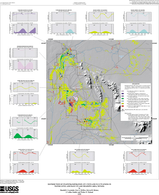
Table 6. Location and general description of sites equipped with micrometeorological instruments and used to determine evapotranspiration (ET) from Ash Meadows area, Nevada
[Geographic coordinates given in degrees, minutes, seconds.]
| Site name | Site identifier (pl. 1) |
Latitude | Longitude | Altitude (feet above sea level) |
Period of data acquisition | Description of dominant vegetation cover1 and soil-moisture conditions2 |
ET-unit identifier3 |
|---|---|---|---|---|---|---|---|
| Bole Spring North | BSNORT | 362227 | 1161811 | 2,180 | January 1996 - September 1997 | Sparse to very sparse cover of bunch grass; soil moisture varies from moist in winter to dry in summer | MBS |
| Bole Spring South | BSSOUT | 362213 | 1161817 | 2,175 | January 1996 - September 1997 | Sparse cover of saltgrass; surface periodically floods during late winter and early spring, otherwise soil moisture varies from moist in winter to very dry in summer | SGV |
| Carson Meadow | CMEADW | 362517 | 1162023 | 2,171 | March 1995 - March 19974 | Dense cover of mixed grasses, clover, and scattered shrubs; soil moisture varies from moist in winter to dry in summer | DMV |
| Fairbanks Meadow | FMEADW | 362859 | 1162018 | 2,249 | March 1997 - September 19975 | Dense cover of saltgrass; surface periodically floods during late winter, otherwise soil moisture varies from wet in winter to dry in summer | DGV |
| Fairbanks Swamp | FSWAMP | 362901 | 1162022 | 2,248 | March 1995 - September 1997 | Dense cover of cattails and reeds; surface flooded throughout year | DWV |
| Lower Crystal Flat | LCFLAT | 362422 | 1162006 | 2,148 | December 1995 - June 1996 | Very sparse cover of bunch grass; soil moisture varies from wet in winter to moist in summer | MBS |
| Peterson Reservoir | PRESVR | 362644 | 1162105 | 2,169 | April 1996 - September 1997 | Open-water body | OWB |
| Rogers Spring 1 | RGSPR1 | 362853 | 1162005 | 2,256 | December 1993 - February 1996 | Sparse to moderate cover of saltgrass; soil moisture varies from moist in winter to very dry in summer | SGV |
| Rogers Spring 2 | RGSPR2 | 362855 | 1161955 | 2,253 | December 1993 - February 1996 | Sparse to moderate cover of wire-grass and saltgrass; soil moisture varies from wet in winter to moist in summer | DGV |
| Spring Meadow | SMEADW | 362538 | 1162120 | 2,139 | June 1995 - September 1997 | Sparse to very sparse cover of saltgrass; soil moisture varies from dry in winter to very dry in summer | SGV |
1 Vegetation cover descriptors: very parse is less than 5 percent; sparse
is 5 to 25 percent; moderate is 25 to 75 percent; and dense is greater than 75 percent.
2 Soil moisture descriptors are presented as relative terms.
3 ET units are described in table 3.
4 Site was destroyed by fire and not replaced.
5 Site still active at time of publication.