
In cooperation with the Red Cedar Lakes Association

Balsam, Hemlock, and Red Cedar Lakes and Their Watershed
Sources of Water and Phosphorus
Modeling the Response in Water Quality to Changes in Phosphorus Loading
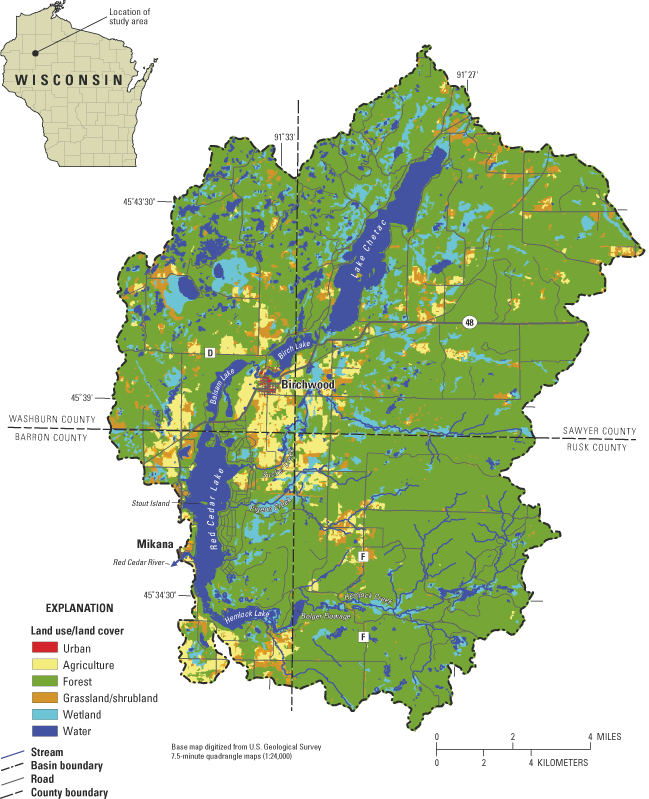
Figure 1. Drainage basin of the Red Cedar Lakes, Wisconsin. Land use/land c...
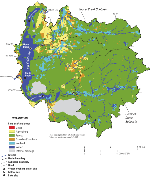
Figure 2. Direct drainage basin of the Red Cedar Lakes, Wisconsin, with dat...
Figure 3. Secchi depth (A), and near-surface concentrations of total phosph...
Figure 4. Secchi depth (A), and near-surface concentrations of total phosph...
Figure 5. Secchi depth (A), and near-surface concentrations of total phosph...
Figure 6. Average summer Trophic State Index (TSI) values based on water-qu...
Figure 7. Schematic of the hydrology of the Red Cedar Lakes, Wisconsin.
Figure 8. Daily average lake stages (above an arbitrary datum) for the Red ...
Figure 9. Water budget for the Red Cedar Lakes, Wisconsin, for October 1, 2...
Figure 10. Phosphorus and suspended sediment concentrations in the Red Ceda...
Figure 11. Phosphorus budget for the Red Cedar Lakes, Wisconsin, for Octobe...
Figure 12. Measured and simulated (with BATHTUB) average summer (May throug...
Figure 13. Simulated changes in near-surface total phosphorus concentration...
Figure 14. Simulated changes in near-surface chlorophyll a concentrations i...
Figure 15. Simulated changes in Secchi depth in Balsam, Red Cedar, and Heml...
Figure 16. Simulated changes in Trophic State Index (TSI) values in Balsam...
Figure 17. Simulated changes in the frequency (percent of days from May thr...
Conversion Factors and Abbreviated Water-Quality Units
Table 1. Morphometric characteristics of the Red Cedar Lakes, Wisconsin
Table 2. Land use/land cover in the Red Cedar Lake watershed, Wisconsin (to...
Table 3. Seasonal average (May through September 2001) water quality in the...
Table 4. Total annual hydrological inputs into the Red Cedar Lakes, Wiscons...
Table 5. Phosphorus inputs, in pounds (lb), to the Red Cedar Lakes, Wiscons...
Table 6. Number of capita years for septic systems used for homes within 50...
Table 7. Algorithms used within BATHTUB to simulate water quality in Red Ce...
Table 8. Calibration coefficients used in BATHTUB simulations of the Red Ce...
Table 9. Simulated algal bloom frequency in the Red Cedar Lakes, Wisconsin,...
Table 10. Measured and simulated phosphorus concentrations, in micrograms p...
Conversion Factors and Abbreviated Water-Quality Units
| Multiply | By | To Obtain |
|---|---|---|
| inch (in.) | 25.4 | millimeter |
| foot (ft) | .3048 | meters |
| mile (mi) | 1.609 | kilometer |
| acre | .004047 | kilometer squared |
| square mile (mi2) | 2.590 | kilometer squared |
| acre-foot (acre-ft) | 1,233. | cubic meter |
| inch per year (in/year) | 25.4 | millimeter per year |
| pound (lb) | 0.4536 | kilogram |
| pound per acre (lb/acre) | 1.121 | kilogram per hectare |
Temperature, in degrees Celsius (°C) can be converted to degrees Fahrenheit (°F) as follows:°F = [1.8 x °C] + 32.
Water year: Water year is defined as the period beginning October 1 and ending September 30, designated by the calendar year in which it ends.
Abbreviated water-quality units used in this report: Chemical concentrations and water temperature are given in metric units. Chemical concentration is given in milligrams per liter (mg/L) or micrograms per liter (µg/L). Milligrams per liter is a unit expressing the concentration of chemical constituents in solution as weight (milligrams) of solute per unit volume (liter) of water. One thousand micrograms per liter is equivalent to one milligram per liter. For concentrations less than 7,000 mg/L, the numerical value is the same as for concentrations in parts per million.
W. Reed Green, Hydrologist, U.S. Geological Survey, Little Rock, Ark.
Patrick W. (Buzz) Sorge, Lake Management Planner, Wisconsin Department of Natural Resources, Eau Claire, Wis.
Mary H. Hele, Red Cedar Lakes Association, Past President and Board Member, Birchwood, Wis.
Mary H. Hele, Red Cedar Lakes Association, Past President and Board Member, Birchwood, Wis.
Michelle M. Greenwood, Cartographer, U.S. Geological Survey, Middleton, Wis.
Jennifer L. Bruce, Geographer, U.S. Geological Survey, Middleton, Wis.
James L. Kennedy, Geographer, U.S. Geological Survey, Middleton, Wis.
Jack H. Green, Hydrologist, U.S. Geological Survey, Middleton, Wis.
Josef G. Schuler, Hydrologic Technician, U.S. Geological Survey, Rice Lake, Wis.
Bernard N. Lenz, Civil Engineer, U.S. Geological Survey, Rice Lake, Wis.
Angel Martin, Jr., Acting Reports Improvement Advisor, U.S. Geological Survey, Urbana, Ill.
The Red Cedar Lakes consist of three mainstem lakes (Balsam, Hemlock and Red Cedar) on the Red Cedar River in Barron and Washburn Counties, Wisconsin. These lakes are productive because of high phosphorus loading, and classified as mesotrophic to eutrophic. Because of concerns that the water quality of these lakes was degrading, three cooperative studies were conducted by the U.S. Geological Survey between 1993 and 2003. As part of these studies, water quality in the lakes was documented in 1993–94, 1996–97, and 2000–01, and water and phosphorus budgets were constructed for water year 2001. Historical water-quality data indicated that the lakes have changed little since the late 1980s. A detailed phosphorus budget indicated that most of the 14,100 pounds of phosphorus input to the lakes during 2001 came from the upstream lakes, streams draining relatively undeveloped land upstream of Hemlock Lake, and ground water. Simulation results from two water-quality models (BATHTUB and WiLMS) indicated that about a 50-percent reduction in phosphorus loading from that measured in 2001 is required for all three lakes to be classified as mesotrophic; therefore, appreciable improvements in the water quality would require improvements in the water quality of the upstream lakes. Although the water quality of the lakes has not changed appreciably in recent years and major improvements in water quality are unlikely without major improvements to upstream lakes, continued efforts to protect the susceptible watershed are necessary to maintain the current level of water quality.
The Red Cedar Lakes consist of three mainstem lakes (Balsam, Hemlock and Red Cedar) on the Red Cedar River in Barron and Washburn Counties, Wisconsin (fig. 1). Headwaters of the Red Cedar River originate as outflow from Lake Chetac (a large, shallow, productive lake), which then flow through Birch Lake (a small, deep, productive lake), Balsam Lake, and into Red Cedar Lake. Additional headwaters originate from Hemlock Creek, which flows through Bolger Flowage, through Hemlock Lake, and into Red Cedar Lake (fig. 1). The narrows separating Balsam and Hemlock Lakes from Red Cedar Lake are sufficiently large that all three lakes have the same water-surface elevation. The Red Cedar River then flows out of Red Cedar Lake and joins with the Brill River prior to flowing into Rice Lake. Approximately 70 mi downstream, the Red Cedar River joins with the Chippewa River; their confluence is in Dunn County, in west-central Wisconsin.
The Red Cedar Lakes have long been considered a highly desirable destination for residents and visitors; however, development within the watershed led to concerns over a possible decline in the water quality of the lakes. As a result of these concerns, the Red Cedar Lakes Association originally was formed around 1980, but disbanded shortly thereafter. The Association was brought back into action in 1990 when further development was proposed in the watershed (M. Hele, Red Cedar Lakes Association, written commun., 2002). The development eventually occurred, and state-of-the-art septic systems were installed to minimize the influence on lake-water quality. However, septic systems generally are not designed to remove nutrients. Once the soil-retention capacity of the soil is exceeded for phosphorus, septic systems can and often do discharge high concentrations of phosphorus to the ground water. By 1992, two issues were identified as primary to the mission of the Association: assessment of the water quality of the lakes and development of a management plan for the Red Cedar Lakes. These issues led to the first cooperative study with the U.S. Geological Survey (USGS) during which the three lakes were monitored in 1993–94. During this time, members of the Association also began collecting water-quality data as part of the Wisconsin Department of Natural Resource's (WDNR's) Self-Help Citizen Lake Monitoring Program (Wisconsin Department of Natural Resources, 2003). After the study with the USGS was completed, it was suggested that 2 additional years of water-quality data would be beneficial to developing a management plan. This suggestion led to the second cooperative study with the USGS, during which the three lakes were monitored in 1996–97.
During this same period, concern over the water quality in lakes throughout the area led to the WDNR's Red Cedar River Basin pilot project (Wisconsin Department of Natural Resources, 1997). The goal of this project was for the WDNR to work with stakeholders throughout the basin (down to the confluence with the Chippewa River) on an innovative approach to watershed management with an initial emphasis on phosphorus control. The first step in setting phosphorus goals for the entire basin was to focus on establishing lake-specific productivity goals that could be achieved by reducing phosphorus loading. It was recognized that management actions for specific mainstem lakes might not be sufficient to achieve their productivity goals unless other upstream lakes also implement management actions and achieve similar productivity goals. Therefore, the WDNR recommended that upstream mainstem lakes, like the Red Cedar Lakes, have initial priority in receiving funds to develop management plans.
As a result of the continuing concern over water quality of the Red Cedar Lakes and lakes throughout the basin, the Association with support of the Red Cedar River Basin pilot project obtained a WDNR Lake Protection grant to fund a third cooperative project with the USGS, during which data were collected in 2000–01. The goals of this project were to evaluate the water quality of the lakes in terms of long-term trends (1980s to the present), to quantify the sources of phosphorus to the lakes, and to determine how the lakes would respond to changes in phosphorus loading. To determine the sensitivity of each of the Red Cedar Lakes to decreases and increases in phosphorus loading, the water-quality model BATHTUB (Walker, 1996) and water-quality models within the Wisconsin Lake Modeling Suite (WiLMS; Panuska and Kreider, 2002) first were calibrated using lake and tributary data collected in 2000–01. The models then were used to simulate water quality with various phosphorus-loading scenarios. This report presents the results of this effort. The ultimate use of the results of this investigation is for the development of comprehensive lake-management plans for the Red Cedar Lakes, which would benefit the water quality in lakes throughout the entire Red Cedar River Basin.
Balsam Lake has a surface area of 295 acres and a volume of 7,400 acre-ft (table 1). Its maximum depth is 49 ft and average depth is 25.1 ft. Most of the water entering the lake is from the outflow from Birch Lake (fig. 1). Water leaves Birch Lake through a bottom withdrawal of a 28-ft high dam. Outflow from Balsam Lake is through a connecting channel to the North Basin of Red Cedar Lake.
Table 1. Morphometric characteristics of the Red Cedar Lakes, Wisconsin
| Lake/Basin | Area(acres) | Length(miles) | Maximum depth(feet) | Mean depth(feet) | Volume(acre-feet) | Drainage area(acres) | Residence time(days) | Phosphorus turnover ratio(for annual loading) |
|---|---|---|---|---|---|---|---|---|
| Balsam Lake | 295 | 1.99 | 49 | 25.1 | 7,400 | 146,500 | 46 | 13.0 |
| Hemlock Lake | 357 | 1.95 | 21 | 8.4 | 2,990 | 17,400 | 31 | 16.0 |
| Red Cedar Lake | 1,840 | 4.52 | 53 | 25.7 | 47,300 | 18,000 | 76 | 7.1 |
| Red Cedar - North Basin | 1,130 | 2.34 | 53 | 27.6 | 31,300 | 15,200 | 126 | 4.7 |
| Red Cedar - South Basin | 708 | 2.18 | 42 | 22.6 | 16,000 | 2,760 | 42 | 12.1 |
1Drainage area of Balsam Lake downstream of gage on County Trunk Highway D is 1,160 acres.
Hemlock Lake has a surface area of 357 acres and a volume of 2,990 acre-ft (table 1). Its maximum depth is 21 ft and average depth is 8.4 ft. Most of the water entering the lake is from Hemlock Creek after flowing through Bolger Flowage (fig. 1). Outflow from Hemlock Lake is through a connecting channel or narrows to the South Basin of Red Cedar Lake.
Red Cedar Lake has a total surface area of 1,840 acres and a volume of 47,300 acre-ft (table 1). Its maximum depth is 53 ft and average depth is 25.7 ft. For model-simulation purposes, the lake was subdivided into two basins (North and South Basins) near Stout Island (fig. 1). The North Basin has a total surface area of 1,130 acres, a volume of 31,300 acre-ft, a maximum depth of 53 ft, and an average depth of 27.6 ft. In addition to flow from Balsam Lake, there are two main tributaries to the North Basin: Sucker Creek and Pigeon Creek. The South Basin has a total surface area of 708 acres, a volume of 16,000 acre-ft, a maximum depth of about 42 ft, and average depth of 22.6 ft. The maximum depth connecting these two basins is about 30 ft. Outflow from Red Cedar Lake is through the dam at Mikana into the Red Cedar River from the South Basin of the lake.
The total drainage area or watershed of the Red Cedar Lakes is about 147 mi2 (fig. 1 and table 2). The area is predominantly forest and wetlands (78 percent). Lakes and streams represent 6.4 percent of the basin. Agriculture and grassland represent about 5.3 and 5.0 percent, respectively. Urban areas, mostly around Birch Lake (Birchwood) and near the outlet (Mikana), represent only about 0.1 percent of the basin. Much of the watershed drains into Lake Chetac and Birch Lake. The area draining directly into the Red Cedar Lakes (fig. 2 and table 2) is about 61 mi2. The area is predominantly forest and wetlands (83 percent). Agriculture and grassland represent about 6.0 and 3.6 percent of the basin, respectively. Most of the agriculture in the basin drains into Sucker Creek. Urban areas, near the outlet (Mikana), represent less than 0.1 percent of the basin. A few parts of the basin, mostly north and southeast of Hemlock Lake, do not drain directly into the lakes, but drain internally to closed depressions. The soils in the area consist mainly of well-drained sandy deposits. Ground water in various locations in the Red Cedar River Basin has been found to have naturally high background concentrations of phosphorus (exceeding 200 µg/L); however, most of the highest concentrations were found south of the Red Cedar Lakes watershed (Wisconsin Department of Natural Resources, 1997).
[Lillesand and others, 1998]
| Land use | Square miles | Percent of total |
|---|---|---|
| Total drainage area | ||
| Urban | 0.18 | 0.1 |
| Agriculture | 7.83 | 5.3 |
| Forest and forested wetland | 115.07 | 78.1 |
| Shrubland | 7.06 | 4.8 |
| Grassland | 7.41 | 5.0 |
| Barren | .46 | .3 |
| Water | 9.37 | 6.4 |
| Total | 147.38 | 100.0 |
| Direct drainage area | ||
| Urban | 0.04 | 0.1 |
| Agriculture | 3.68 | 6.0 |
| Forest and forested wetland | 50.78 | 83.4 |
| Shrubland | 3.11 | 5.1 |
| Grassland | 2.17 | 3.6 |
| Barren | .18 | .3 |
| Water | .95 | 1.6 |
| Total | 60.91 | 100.0 |
Water-quality sampling in each of the three Red Cedar Lakes (two locations in Red Cedar Lake: North and South Basin) was conducted by the USGS in 1993–94, 1996–97, and 2001. During each year, the lakes/basins were sampled near their deepest location (fig. 2) in late winter, spring (April or May), June, July, and August. In addition, in 2001, the four sites were sampled in September. During each sampling, profiles of water temperature, dissolved oxygen, specific conductance, and pH were measured with a multiparameter meter, and Secchi depths were measured with a standard black-and-white Secchi disk during open-water periods. At all locations, water samples were collected near the surface (1.5 ft) and bottom of the water column (approximately 3 ft above the bottom); however, in 2001, no near-bottom samples were collected in the South Basin of Red Cedar Lake in March, May, June, and July. Water samples were collected at additional depths near the top and middle of the hypolimnion (the deep colder layer of water in the lake) at each site in August and September 2001 to better describe the distribution of phosphorus and enable phosphorus release from the sediments to be quantified. All water samples were collected with a Van Dorn sampler and analyzed for total phosphorus. During all open-water samplings, surface samples also were analyzed for chlorophyll a. During spring overturn, the surface and bottom water samples also were analyzed for color, turbidity, hardness, alkalinity, solids, calcium, chloride, iron, magnesium, manganese, potassium, silica, sodium, and sulfate; only surface samples were analyzed for these constituents in 2001. These data were published in annual USGS data reports (the most recent report being U.S. Geological Survey, Wisconsin District Lake-Studies Team, 2002). Additional water-quality data have been collected from each of the lakes as part of the Wisconsin Self-Help Citizen Lake Monitoring Program (Wisconsin Department of Natural Resources, 2003). Self-help data included Secchi depth, surface total phosphorus and chlorophyll a concentrations, and perceived water-quality conditions. These data are archived in the Wisconsin Self-Help database that is available on the World Wide Web (Wisconsin Department of Natural Resources, 2002). All chemical analyses of water samples were done by the Wisconsin State Laboratory of Hygiene in accordance with standard analytical procedures described in the "Manual of Analytical Methods, Inorganic Chemistry Unit" (Wisconsin State Laboratory of Hygiene, 1993).
One method of classifying the water quality of a lake is by computing water-quality or trophic state index (TSI) values as developed by Carlson (1977) and modified for Wisconsin lakes by Lillie and others (1993). The indices, based on near-surface concentrations of phosphorus and chlorophyll a, and on Secchi depths, were developed to place these three characteristics on similar scales to allow comparison of different lakes. TSI values based on phosphorus concentrations (TSIP), chlorophyll a concentrations (TSIC), and Secchi depths (TSISD) were computed for each sampling with equations 1–3 and were used to compute summer (May through September) average TSI values:
TSIP =28.24 + 17.81 [log10P (in micrograms per liter)](1)
TSIC =34.82 + 17.41 [log 10 chlorophyll a (in micrograms per liter)](2)
TSISD = 77.13 – 33.2 [log 10 Secchi depth (in feet)](3)
Oligotrophic lakes (TSI values less than 40) have a limited supply of nutrients, typically are clear with low algal populations and low phosphorus concentrations, and typically contain oxygen throughout the year in their deepest zones (Wisconsin Department of Natural Resources, 1992). Mesotrophic lakes (TSI values between 40 and 50) have a moderate supply of nutrients, moderate clarity, and are prone to moderate algal blooms; occasional oxygen depletions in the deepest zones of the lake are possible. Eutrophic lakes (TSI values greater than 50) are nutrient rich with correspondingly severe water-quality problems, such as frequent seasonal algal blooms; oxygen depletion is common in the deeper zones of the lake, and clarity typically is poor.
To describe the flow, water quality, and phosphorus and sediment loading from the watershed and upstream lakes, three inflow sites were sampled (fig. 2). A site downstream of Birch Lake (at County Trunk D) was used to monitor all of the inputs to the Red Cedar Lakes entering from the upstream lakes. Sites on Sucker Creek (at Loch Lomond Boulevard near Birchwood) and Hemlock Creek (at County Trunk Highway F) were chosen because they are major tributaries and were thought to best represent conditions in the watershed. Sucker Creek has a 7,630-acre subwatershed with large agricultural areas, and Hemlock Creek has a 13,100-acre subwatershed dominated by forest and wetlands (fig. 2). To describe the flow, water quality, and nutrients leaving the lakes, the Red Cedar River (lake outlet) was monitored just downstream of the dam. Water levels at these four sites were measured continuously (every 15 minutes) and used to determine flow by use of stage-discharge relations. These data then were used to compute daily average flows for each site for water year (WY) 2001 (October 1, 2000, to September 30, 2001). The 15-minute data are stored in the National Water Information System database (U.S. Geological Survey, 1998) and daily average data were published in the annual USGS data report (Waschbusch and others, 2002). These data were used to estimate the total flow to and from the lakes, described in the section on "Sources of Water and Phosphorus."
Water samples were collected from each of the three inflow sites and analyzed for total phosphorus and suspended sediment concentrations. Storm-runoff samples were collected at Sucker and Hemlock Creeks by means of stage-activated automatic samplers. Additional samples were collected manually, by use of the equal-width-increment (EWI) method described by Edwards and Glysson (1999), at times when automated samples also were collected, to evaluate the representativeness of the automated samples. EWI samples also were collected at low flow at these sites to estimate loading during these conditions. A total of 98 and 74 samples were collected and analyzed in Sucker and Hemlock Creeks, respectively. At the outlet from Birch Lake, samples were collected manually at monthly intervals because only gradual changes in water quality were expected. About 20 percent of the inflow samples were analyzed for dissolved ortho-phosphorus. At the outlet from Red Cedar Lake, samples also were collected monthly, but only analyzed for total phosphorus. All total and dissolved ortho-phosphorus analyses were performed by the Wisconsin State Laboratory of Hygiene (Wisconsin State Laboratory of Hygiene, 1993) and suspended sediment analyses were performed by the USGS Iowa Sediment Laboratory in accordance with standard analytical procedures described by Fishman, and others (1994). Daily phosphorus and suspended sediment loads then were computed for each site, except the Red Cedar Outlet where only phosphorus loads were computed, for WY2001 by use of the integration method described by Porterfield (1972). All water-quality data and computed loads were published in annual USGS data reports (Waschbusch and others, 2002) and stored in the National Water Information System database (U.S. Geological Survey, 1998).
Daily lake stages were estimated from continuous (every 15 minutes) water-elevation measurements recorded at the outlet of Red Cedar Lake (fig. 2). During the snow-free period, precipitation was measured continuously at the stream gages near the Birch Lake outlet, Hemlock Creek, and near the Red Cedar Lake outlet. Precipitation on the lakes was assumed to be the average of that measured at these three gages. During the colder periods, daily precipitation was assumed to be the average of that measured by weather observers in Couderay and Rice Lake, Wisconsin (National Oceanographic and Atmospheric Administration Stations 1847 and 7132, respectively).
Water quality varies among the Red Cedar Lakes; therefore, the water quality of each lake is described separately and then compared. The most extensive year of water-quality data collection was in 2001; therefore, these data primarily were used to describe seasonal changes in the water quality of the lakes.
Balsam Lake is a dimictic lake, meaning that the lake thermally stratifies throughout summer and under the ice during winter. During summer, the thermocline (depth range where there is a rapid temperature change) developed in early June and stayed well established through September. The thermocline usually developed from around 13 to 16 ft from the surface. Bottom temperatures usually were from around 7 to 9°C, and changed little throughout summer. Dissolved oxygen concentrations were near saturation throughout the lake just after the ice melted, but oxygen quickly was depleted below the thermocline by mid June. Throughout most of summer, dissolved oxygen concentrations were near zero below the thermocline. During late fall, the lake completely mixed and dissolved oxygen concentrations at all depths were near saturation. Reverse thermal stratification developed under the ice, with bottom temperatures warming to near 5°C by late winter while temperatures just beneath the ice remained near 0°C. Dissolved oxygen concentrations usually decreased as winter progressed but usually remained above 5 mg/L in the upper 10 ft of the lake; however, below that depth, concentrations decreased to near 0 mg/L by late winter. The specific conductance throughout the lake at spring and fall overturn and near the surface during other periods was about 150 µS cm-1, but increased to over 200 µS cm-1 near the bottom of the lake during late summer and late winter. The pH throughout the lake was about 7 (all pH values are in standard units) during spring and winter, but photosynthesis by aquatic plants and algae during summer caused concentrations in the epilimnion (the shallower, warmer layer of water in the lake) to occasionally increase to just less than 9 (the State pH water-quality standard) in July and August.
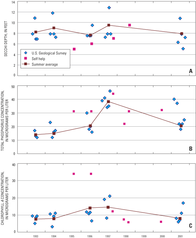
The summer average water clarity in Balsam Lake, as measured with a Secchi disk, was about 8.2 ft, but each year had at least one monthly measurement of about 11–13 ft (fig. 3a). Secchi depths less than 6 ft indicate eutrophic conditions. The average Secchi depth during May through September 2001 was 7.4 ft (table 3). Little change in Secchi depths were observed from 1993 to 2001 (fig. 3).
[µg/L, micrograms per liter, c.v., coefficient of variation]
| Lake/Basin | Total phosphorus | Secchi depth | Chlorophyll a | |||||
|---|---|---|---|---|---|---|---|---|
| µg/L | c.v. | feet | c.v. | µg/L | c.v. | |||
| Balsam Lake | 24.8 | 0.33 | 7.4 | 0.29 | 9.8 | 0.45 | ||
| Hemlock Lake | 35.8 | .24 | 5.2 | .16 | 13.7 | .73 | ||
| Red Cedar Lake1 | 26.2 | .20 | 7.6 | .26 | 9.1 | .52 | ||
| Red Cedar - North Basin |
26.2 | .20 | 7.7 | .24 | 10.5 | .51 | ||
| Red Cedar - South Basin |
26.2 | .19 | 7.4 | .28 | 7.7 | .53 | ||
1Values based on averaging water-quality data from the North and South Basins of Red Cedar Lake.
Phosphorus and nitrogen are essential nutrients for plant growth and are the nutrients that usually limit algal growth in Midwestern lakes. High nutrient concentrations can cause high algal populations (blooms) and can, therefore, be the cause of eutrophication (that is, accelerated aging and increased productivity) of lakes. Phosphorus concentrations greater than about 17–20 µg/L indicate eutrophic conditions. Near-surface total phosphorus concentrations ranged from 12 to 46 µg/L (fig. 3b). The average concentration in Balsam Lake during May through September 2001 was 24.8 µg/L (table 3). Phosphorus concentrations in the lake appear to have increased slightly since 1993. Near-bottom phosphorus concentrations increased dramatically after the onset of anoxic conditions, which indicates a release of phosphorus from the lake sediments. Near-bottom total phosphorus concentrations typically increased to over 500 µg/L in late summer and winter. A near-surface dissolved ortho-phosphorus concentration of 9 µg/L was measured during July 2001.
Near-surface total nitrogen concentration (computed as the sum of Kjeldahl nitrogen and dissolved nitrite plus nitrate) was measured at spring overturn in May 2001 and dissolved nitrogen was measured during July 2001. During spring overturn, the total nitrogen concentration was 787 µg/L and in July the near-surface dissolved nitrogen concentration was 220 µg/L.
The ratio of the concentrations of total nitrogen to total phosphorus (N:P ratio) often is used to determine the potential limiting nutrient in a lake. The specific value of this ratio that determines which nutrient potentially is limiting, varies under different conditions such as water temperature, light intensity, and nutrient deficiencies (Correll, 1998); however, a ratio greater than from about 12:1 to about 16:1, by weight, usually indicates that phosphorus should be the potentially limiting nutrient. The N:P ratio in Balsam Lake during spring was 21:1 and in July the near-surface dissolved N:P ratio was 24:1. Therefore, phosphorus typically should be the nutrient limiting algal growth in Balsam Lake and is the nutrient to focus on when considering management efforts to improve water quality.
Chlorophyll a is a photosynthetic pigment found in algae and other green plants. Its concentration, therefore, commonly is used as a measure of the density of the algal population of a lake. Concentrations greater than about 7–10 µg/L indicate eutrophic conditions and greater than 20–30 µg/L usually are considered to be associated with algal blooms. During the study period, near-surface chlorophyll a concentrations ranged from 3 to 34 µg/L (fig. 3). The highest concentrations were measured from 1995 through 1997. The average concentration in Balsam Lake during May through September 2001 was 9.8 µg/L (table 3). From 1993 to 2001, there was no apparent long-term change in chlorophyll a concentrations (fig. 3).
Hemlock Lake, the shallowest of the three lakes, also is a dimictic lake. During summer, the thermocline developed in early June and was present at about 13 ft in July and August. The temperature gradient in the thermocline was weaker in Hemlock Lake than in Balsam Lake. Bottom temperatures usually were from around 14 to 15°C and changed little throughout summer. Dissolved oxygen was quickly depleted below the thermocline (13 ft) by mid June. Thermal stratification developed under the ice, with bottom temperatures warming to near 4°C by late winter, whereas temperatures just beneath the ice remained near 0°C. Dissolved oxygen concentrations decreased as winter progressed but usually remained above 5 mg/L in the upper 5 ft of the lake; however, below that depth concentrations decreased to near 0 mg/L by late winter. The specific conductance in Hemlock Lake was the lowest of the three lakes. The specific conductance throughout the lake at spring and fall overturn and near the surface during other periods was near 100 µS cm-1, but increased to over 150 µS cm-1 near the bottom during late summer. The pH throughout the lake typically was about 7 to 8 during spring and winter, but occasionally increased to near 9 during July and August in the epilimnion. Only on one occasion (July 2001) did pH values in the epilimnion reach the State pH water-quality standard of 9.
Secchi depths in Hemlock Lake ranged from 2.5 to 11 ft (fig. 4a). The average Secchi depth during May through September 2001 was 5.2 ft (table 3). No long-term changes were found in Secchi depths from 1993 to 2001 (fig. 4a).
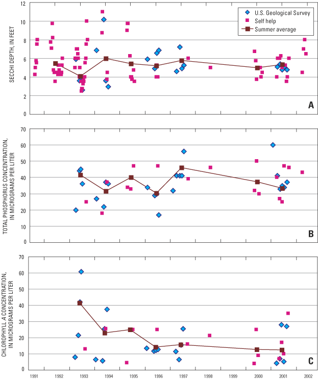
Hemlock Lake had the highest near-surface total phosphorus concentrations of the three lakes. Near-surface total phosphorus concentrations ranged from 17 to 60 µg/L (fig. 4b). The average concentration in Hemlock Lake during May through September 2001 was 35.8 µg/L (table 3). No long-term changes in phosphorus concentrations have occurred since 1993. A near-surface dissolved ortho-phosphorus concentration of 11 µg/L was measured during July 2001. Near-bottom phosphorus concentrations increased dramatically when anoxic conditions were present. Near-bottom total phosphorus concentrations were measured as high as about 700 µg/L in August, but were variable. Near-bottom total phosphorus concentrations increased little during winter.
In 2001, during spring overturn, the total nitrogen concentration was 595 µg/L and in July the near-surface dissolved nitrogen concentration was 280 µg/L. The N:P ratio in Hemlock Lake during spring was 15:1 and in July the near-surface N:P ratio was 25:1. Therefore, phosphorus typically should be the nutrient limiting algal growth.
Hemlock Lake had the highest chlorophyll a concentrations of the three lakes. Near-surface chlorophyll a concentrations ranged from 4 to 61 µg/L (fig. 4c), with an average concentration during May through September 2001 of 13.7 µg/L (table 3). Chlorophyll a concentrations may have decreased slightly from 1993 to 2001.
The extent of vertical mixing in the two basins in Red Cedar Lake is quite different. The North Basin, being deeper, is a dimictic lake, had strong thermal stratification set up in early June, and it stayed stratified through September. The South Basin, being shallower than the North Basin, had weak stratification set up and break down various times during summer. The thermocline in the North Basin developed in early June and was present at about 20 to 26 ft in July through September. Bottom temperatures in the North Basin were usually from around 10 to 11°C and changed little throughout summer; however, those in the South Basin gradually increased throughout summer. In the North Basin, dissolved oxygen was depleted quickly below the thermocline by mid July; however, in the South Basin low dissolved oxygen concentrations only were occasionally found just above the bottom.
Throughout Red Cedar Lake, thermal stratification developed under the ice, with bottom temperatures warming to near 4°C by late winter, whereas temperatures just beneath the ice remained near 0°C. Dissolved oxygen concentrations usually decreased as winter progressed but usually remained above 10 mg/L down to about 20 ft throughout the lake; however, below that depth concentrations quickly dropped to near 0 mg/L. Because most of the area near the center of the South Basin is only about 25 ft deep, dissolved oxygen concentrations throughout the basin usually were about 8 mg/L even in late winter. The specific conductance throughout the lake during spring and fall overturn and near the surface during other periods was near 125 µS cm-1, but in the North Basin increased to about 200 µS cm-1 near the bottom during late summer. The pH throughout the lake typically was about from 7 to 8 during spring and winter, but occasionally increased to just less than 9 in July and August.
Although differences are present in the near-surface water quality between the North and South Basins on individual dates, the summer average values for Secchi depth, total phosphorus, and chlorophyll a were similar when data only collected on the same dates were examined. Therefore, because the North Basin has more extensive long-term records because of the WDNR Citizen Lake Monitoring Program, only the data for the North Basin are presented in figure 5.
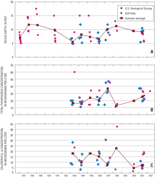
Secchi depths in Red Cedar Lake usually ranged from 5 to 17 ft (fig. 5a); however, one Secchi depth in the South Basin was as shallow as 4 ft. The average Secchi depth during May through September 2001 was 7.7 ft and 7.4 ft, in the North and South Basins, respectively (table 3). Although there is considerable interannual variability, no long-term changes were found in Secchi depths from 1987 to 2001 (fig. 5a). The longer period of record (starting in 1987) enables the data collected since 1993 to be placed in a better long-term perspective. Data from 1993 to 2001 would suggest that there was a long-term increase in Secchi depths; however, the earlier data indicate that the mid 1990s actually were from 4 to 5 years of poor clarity and no long-term trend in clarity is present.
Near-surface total phosphorus concentrations ranged from 11 to 60 µg/L (fig. 5b). The average concentration throughout Red Cedar Lake during May through September 2001 was 26.2 µg/L (table 3). A small increase in phosphorus concentrations may have occurred since 1993; however, most of the variance in phosphorus concentrations was associated with high concentrations in 1997. A near-surface dissolved ortho-phosphorus concentration of 11 µg/L was measured in the North Basin during July 2001. Near-bottom phosphorus concentrations dramatically increased with the onset of anoxic conditions in the North Basin. Near-bottom total phosphorus concentrations in the North Basin were measured as high as 885 µg/L in late summer. Anoxic conditions were not found in the South Basin and, therefore, concentrations did not increase during summer. In late winter, phosphorus concentrations were measured as high as 1,500 µg/L (in 1997) in the North Basin, although, other near-bottom measurements during winter in other years were much lower than this concentration.
In 2001, during spring overturn, the total nitrogen concentration in the North Basin was 900 µg/L and in July the near-surface dissolved nitrogen concentration was 281 µg/L. The N:P ratio in Red Cedar Lake during spring was 24:1 and in July the near-surface N:P ratio was 26:1. Therefore, phosphorus typically should be the nutrient limiting algal growth. Nitrogen concentrations were not measured in the South Basin.
Near-surface chlorophyll a concentrations ranged from 1.6 to 43 µg/L (fig. 5c), with an average concentration during May through September 2001 of 10.5 µg/L and 7.7 µg/L in the North and South Basins, respectively (table 3). Chlorophyll a concentrations may have decreased slightly from 1993 to 2001, which would agree with the changes observed in Secchi depths during this period. However, the longer Secchi depth record would suggest that there probably was no long-term change in chlorophyll a concentrations.
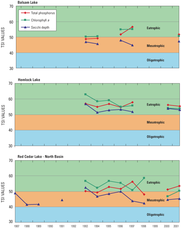
Average summer Trophic State Index values (TSIs), based on total phosphorus and chlorophyll a concentrations from May through September, indicate that Balsam, Red Cedar, and Hemlock Lakes are eutrophic (fig. 6). However, water clarity in all of the lakes was slightly better than would be expected based on total phosphorus and chlorophyll a concentrations. TSIs based on Secchi depth indicate that Balsam and Red Cedar Lakes should be classified as mesotrophic. When all three TSIs are considered, the lakes would be classified as mesotrophic to eutrophic. All three TSIs indicate that Hemlock Lake is more productive than the other two lakes. There were no consistent long-term trends in the TSIs for any of the lakes, except for the TSIs based on chlorophyll a concentrations in Hemlock Lake that may have improved (decreased) slightly.
Because the productivity in each of the lakes usually should be limited by the input of phosphorus, reduction in the phosphorus input to the lake would be a logical management goal. Most of the phosphorus enters the lake associated with the input of water. Therefore, to determine where the water and phosphorus originates and how changes in phosphorus loading would affect the trophic status of the lakes, water and phosphorus budgets were determined for each lake.
The hydrology of each of the lakes can be described in terms of components of their water budgets (fig. 7). The water budget for each lake may be represented by the equation
ΔS = (PPT + SWIn + GWIn) – (Evap + SWOut + GWOut),(4)
where ΔS is the change in the volume of water stored in the lake during the period of interest and is equal to the sum of the volumes of water entering the lake minus the sum of the volumes leaving the lake. Water enters the lake as precipitation (PPT), surface-water inflow (SWIn, including inflow from a connected upstream lake), and ground-water inflow (GWIn). Water leaves the lake through evaporation (Evap), surface-water outflow (SWOut, including that to a connected downstream lake), and ground-water outflow (GWOut).
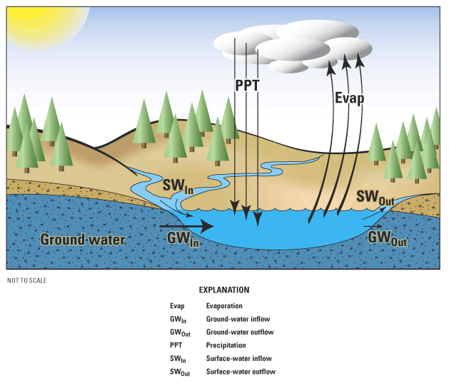
Figure 7. Schematic of the hydrology of the Red Cedar Lakes, Wisconsin.
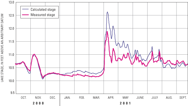
The water budget for all three lakes treated as single body of water, or the collective water budget, was estimated first, and then each individual lake's water budget was estimated. Each term in the collective water budget was computed on a daily basis from October 1, 2000, to September 30, 2001. Changes in the volume of the lakes were determined from lake stages monitored near the outlet dam, assuming a constant surface area. Lake stage ranged from a minimum of 10.14 ft (relative to an arbitrary datum) in late November to a maximum of 11.87 ft in mid April (fig. 8). The lake stage fluctuated by about ± 0.5 ft from October through late November, was relatively constant throughout winter, rose rapidly by about 1.5 ft during snow melt and rain in early April, decreased quickly through April, and then fluctuated only slightly until September. The lake stage at the end of September 2001 was the same as at the beginning of the 1-year period; therefore, ΔS = 0.0 for that year.
During the non-freezing period, precipitation (PPT) was estimated to be the average of the precipitation measured at the USGS gages at Birch Lake outlet, Hemlock Creek, and at the Red Cedar Lake outlet. For the freezing period, daily precipitation was estimated to be the average of precipitation measured by National Weather Service observers in Couderay and Rice Lake, Wisconsin. The total annual precipitation was 40.36 in. or 8,390 acre-ft on the surface of the lake (table 4), which is about 8 in. more than the long-term average for the area. The most unusual precipitation fell in April when there was about 7.8 in. of rain, which is over 5 in. more than normal.
[NA, not applicable]
| Hydrologic component | Balsam Lake | Hemlock Lake | Red Cedar North Basin | Red CedarSouth Basin | Red Cedar Lakes |
|---|---|---|---|---|---|
| Inputs (acre-feet) | |||||
| Precipitation | 993 | 1,200 | 3,810 | 2,380 | 8,390 |
| Inflow (gaged) | 50,000 | 20,400 | 8,860 | NA | 79,300 |
| Ungaged inflow | 1,340 | 5,040 | 8,810 | 3,200 | 18,400 |
| Upstream lake | NA | NA | 58,700 | 121,000 | NA |
| Ground water | 7,060 | 7,840 | 10,200 | 11,000 | 36,100 |
| Total inputs | 59,400 | 34,500 | 90,400 | 138,000 | 142,000 |
| Outputs (acre-feet) | |||||
| Evaporation | 738 | 894 | 2,830 | 1,770 | 6,230 |
| Outflow (or transport to adjacent lake/basin) | 58,700 | 33,600 | 87,500 | 136,000 | 136,000 |
| Total outputs | 59,400 | 34,500 | 90,400 | 138,000 | 142,000 |
Daily surface-water inflow, SWIn, was divided into that measured from Birch Lake, that measured at Sucker Creek (drainage area of 7,630 acres), that measured at Hemlock Creek (drainage area of 13,100 acres), and that estimated from the remaining ungaged areas (15,900 acres). The total annual surface-water input to all Red Cedar Lakes from gaged areas was 79,300 acre-ft (table 4), which equates to about 32 ft on the surface of the lakes. The total annual surface-water input from gaged areas into Balsam Lake (from Birch Lake) was 50,000 acre-ft, into Hemlock Lake (from Hemlock Creek) was 20,400 acre-ft, and North Basin of Red Cedar Lake (from Sucker Creek) was 8,860 acre-ft. Daily surface-water inflows from all the remaining ungaged areas were estimated from the unit-area water yields determined for the Sucker Creek watershed. Flows at Sucker Creek were used to estimate flow from all of the remaining ungaged areas because the drainage area upstream of the gage on Hemlock Creek had more wetlands and impounded flow than the other ungaged areas in the watershed. The total annual surface-water inflow from ungaged areas to all of the Red Cedar Lakes was estimated to be 18,400 acre-ft (table 4), which equates to about 7.4 ft on the surface of the lakes. Ungaged inflows to the individual lakes/basins are given in table 4.
Runoff during this period was higher than normal due to the higher than normal precipitation, especially in April. Many streams in northwestern Wisconsin had runoff approximately 130 to 140 percent above normal during the 1-year study period (Waschbusch, and others, 2002).
Total annual evaporation from the lake was estimated from the Evaporation Atlas for the United States (Farnsworth and others, 1982) to be 30 in/yr (6,230 acre-ft). The total evaporation was then partitioned to daily rates based on estimated monthly pan evaporation rates for LaCrosse, Wis. (Farnsworth and Thompson, 1982).
On the basis of the elevation of the surface of the Red Cedar Lakes relative to the elevation of water in nearby lakes and streams, it was assumed that ground water only moved from the aquifer to the lakes and not from the lakes to the aquifer. A total ground-water input to the lakes of 36,100 acre-ft (table 4), which equates to about a change in water level of about 14.5 ft, was then computed as the residual in the water-budget equation (Eq. 4). To determine the daily input of ground water, the temporal distribution of ground water flowing into the lakes was assumed to be similar to the temporal distribution of base flow in Sucker Creek. The total ground-water input was then partitioned to the individual lakes based on the relative proportion of shoreline. The shoreline length of Balsam Lake was about 20 percent of the entire shoreline of the Red Cedar Lakes and, therefore, received 20 percent of the daily ground-water input; the North Basin of Red Cedar Lake received 28 percent of the input; the South Basin received 30 percent of the input; and Hemlock Lake received 22 percent of the ground-water input.
The complete daily water budget fairly accurately simulated the changes in the water level of the lakes (fig. 8). The largest error in the hydrologic balance of the lakes was about 0.75 ft in early April during spring runoff. This difference probably was caused by overestimating the rate of input from ungaged areas. However, by the middle of May, the estimated and measured water levels were similar, which indicates the overall water budget was accurate.
A large component of the water budget of the individual lakes/basins is flow from one lake/basin to another. This flow was computed using an adaptation to equation 4. Because ΔS for the year was 0.0 and GWOut was assumed to be 0.0, outflow from a particular lake/basin was determined by the equation
SWOut = (PPT + SWIn + GWIn) – Evap,(5)
or by subtracting evaporation from the total annual inputs of water (table 4). Flow from Balsam Lake to the North Basin of Red Cedar Lake was estimated to be 58,700 acre-ft; flow from the North Basin to the South Basin was estimated to be 87,500 acre-ft, and flow from Hemlock Lake to the South Basin was estimated to be 33,600 acre-ft.
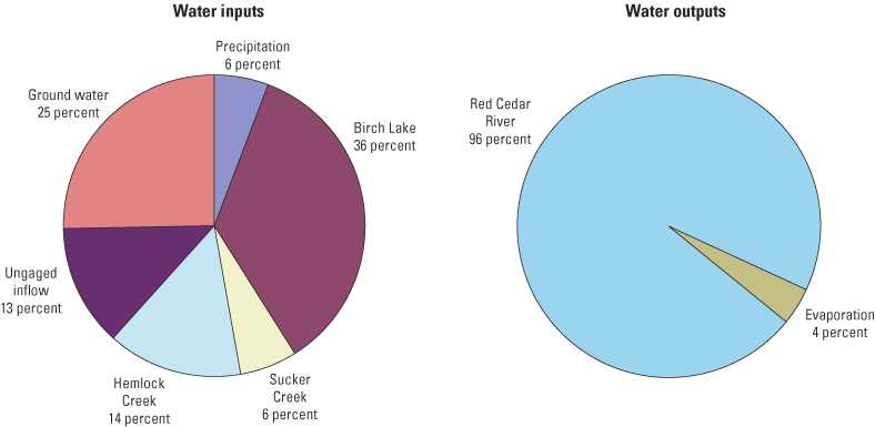
In summary, the major sources of water to the Red Cedar Lakes are from Birch Lake (36 percent), gaged and ungaged surface-water inflow (33 percent), and ground water (25 percent) (table 4 and fig. 9). Direct precipitation contributed 6 percent of the total water input to the lake. The major output of water from the lake was through its outlet (96 percent) and secondarily through evaporation (4 percent). The major output of water from Balsam Lake, Hemlock Lake, and the North Basin of Red Cedar Lake is to the next downstream lake/basin. These outputs are the major sources of water to the North and South Basins of Red Cedar Lake.
To help define where the phosphorus in the Red Cedar Lakes originates and how much leaves the lakes, a detailed phosphorus budget was computed for this 1-year study period. Sources of phosphorus to the lakes include precipitation, surface-water inflow (from gaged and ungaged flow including that transported from adjacent lakes/basins), ground water (including seepage out of the Birchwood Sewage-Disposal Pond that is considered a point source), and contributions from septic systems. Because some of the phosphorus transported in the streams is attached to suspended sediment particles, suspended sediment concentrations and loads in inflowing streams also were examined. Almost all of the phosphorus that enters the lake is either exported out the outlet of the lake or is deposited in the lake sediments.
The phosphorus concentration in precipitation was assumed to be constant at 7 µg/L, a value suggested by Rose (1993) for northern Wisconsin. Therefore, direct precipitation contributed about 160 lb of phosphorus to the lakes during the study year (table 5). Monthly loadings to individual lakes are given in table 5.
[NC, not computed; NCM, not computed on a monthly basis]
| Month | Precipitation | Gaged | Ungaged | Upstream lake | Ground water | Birchwood Disposal Pond | Septic systems | Total |
|---|---|---|---|---|---|---|---|---|
| Balsam Lake | ||||||||
| October | 0.4 | 221 | 1.5 | 1NC | 29.1 | 17.3 | 2.4 | 272 |
| November | 2.8 | 721 | 8.7 | 1NC | 40.7 | 17.3 | 2.4 | 793 |
| December | .4 | 360 | 2.4 | 1NC | 44.5 | 17.3 | 2.4 | 427 |
| January | .6 | 229 | 2.4 | 1NC | 41.4 | 17.3 | 2.4 | 293 |
| February | .7 | 219 | 2.6 | 1NC | 34.6 | 17.3 | 2.4 | 276 |
| March | .3 | 203 | 4.0 | 1NC | 35.4 | 17.3 | 2.4 | 263 |
| April | 3.1 | 1,630 | 80.9 | 1NC | 39.1 | 17.3 | 2.4 | 1,780 |
| May | 2.0 | 585 | 17.8 | 1NC | 48.6 | 17.3 | 2.4 | 673 |
| June | 2.5 | 531 | 23.4 | 1NC | 42.2 | 17.3 | 2.4 | 618 |
| July | 2.0 | 148 | 6.3 | 1NC | 39.4 | 17.3 | 2.4 | 216 |
| August | 3.0 | 312 | 9.9 | 1NC | 41.4 | 17.3 | 2.4 | 386 |
| September | 1.0 | 229 | 2.9 | 1NC | 43.1 | 17.3 | 2.4 | 296 |
| Total annual | 18.9 | 5,390 | 163 | 1NC | 480 | 207 | 28.7 | 6,290 |
| Hemlock Lake | ||||||||
| October | .5 | 27 | 5.8 | 0 | 32.3 | 0.0 | 1.9 | 67 |
| November | 3.4 | 76 | 32.5 | 0 | 45.2 | .0 | 1.9 | 159 |
| December | .5 | 61 | 9.1 | 0 | 49.4 | .0 | 1.9 | 122 |
| January | .8 | 102 | 9.0 | 0 | 46.0 | .0 | 1.9 | 159 |
| February | .9 | 121 | 9.8 | 0 | 38.5 | .0 | 1.9 | 172 |
| March | .4 | 156 | 14.9 | 0 | 39.3 | .0 | 1.9 | 212 |
| April | 3.8 | 716 | 304 | 0 | 43.5 | .0 | 1.9 | 1,070 |
| May | 2.4 | 243 | 67.0 | 0 | 54.1 | .0 | 1.9 | 369 |
| June | 3.0 | 275 | 87.9 | 0 | 46.9 | .0 | 1.9 | 414 |
| July | 2.4 | 170 | 23.8 | 0 | 43.8 | .0 | 1.9 | 242 |
| August | 3.6 | 284 | 37.2 | 0 | 46.0 | .0 | 1.9 | 373 |
| September | 1.2 | 74 | 10.8 | 0 | 47.9 | .0 | 1.9 | 136 |
| Total annual | 22.9 | 2,300 | 612 | 0 | 533 | 0.0 | 23.1 | 3,490 |
| Red Cedar - North Basin | ||||||||
| October | 1.5 | 10 | 10.1 | NCM | 42.1 | 0.0 | 8.1 | 72 |
| November | 10.7 | 57 | 56.8 | NCM | 58.8 | .0 | 8.1 | 191 |
| December | 1.6 | 16 | 15.9 | NCM | 64.3 | .0 | 8.1 | 106 |
| January | 2.4 | 16 | 15.7 | NCM | 59.7 | .0 | 8.1 | 102 |
| February | 2.8 | 17 | 17.1 | NCM | 50.0 | .0 | 8.1 | 95 |
| March | 1.2 | 26 | 26.1 | NCM | 51.1 | .0 | 8.1 | 113 |
| April | 12.1 | 534 | 531 | NCM | 56.5 | .0 | 8.1 | 1,140 |
| May | 7.7 | 118 | 117 | NCM | 70.3 | .0 | 8.1 | 321 |
| June | 9.4 | 154 | 154 | NCM | 60.9 | .0 | 8.1 | 386 |
| July | 7.7 | 42 | 41.6 | NCM | 56.9 | .0 | 8.1 | 156 |
| August | 11.4 | 65 | 65.1 | NCM | 59.8 | .0 | 8.1 | 210 |
| September | 3.9 | 19 | 19.0 | NCM | 62.3 | .0 | 8.1 | 112 |
| Total annual | 72.5 | 1,070 | 1,070 | 24,850 | 693 | 0.0 | 96.8 | 7,860 |
| Red Cedar - South Basin | ||||||||
| October | 1.0 | 0 | 3.7 | NCM | 45.3 | 0.0 | 8.1 | 58 |
| November | 6.7 | 0 | 20.6 | NCM | 63.3 | .0 | 8.1 | 99 |
| December | 1.0 | 0 | 5.8 | NCM | 69.2 | .0 | 8.1 | 84 |
| January | 1.5 | 0 | 5.7 | NCM | 64.3 | .0 | 8.1 | 80 |
| February | 1.8 | 0 | 6.2 | NCM | 53.9 | .0 | 8.1 | 70 |
| March | .7 | 0 | 9.5 | NCM | 55.0 | .0 | 8.1 | 73 |
| April | 7.5 | 0 | 193 | NCM | 60.9 | .0 | 8.1 | 269 |
| May | 4.8 | 0 | 42.5 | NCM | 75.7 | .0 | 8.1 | 131 |
| June | 5.9 | 0 | 55.8 | NCM | 65.6 | .0 | 8.1 | 135 |
| July | 4.8 | 0 | 15.1 | NCM | 61.3 | .0 | 8.1 | 89 |
| August | 7.1 | 0 | 23.6 | NCM | 64.4 | .0 | 8.1 | 103 |
| September | 2.5 | 0 | 6.9 | NCM | 67.0 | .0 | 8.1 | 85 |
| Total annual | 45.3 | 0 | 388 | 311,100 | 746 | 0.0 | 96.8 | 12,400 |
| All Red Cedar Lakes (total) | ||||||||
| October | 3.4 | 258 | 21.1 | 1NC | 149 | 17.3 | 20.4 | 469 |
| November | 23.5 | 854 | 119 | 1NC | 208 | 17.3 | 20.4 | 1,240 |
| December | 3.5 | 436 | 33.2 | 1NC | 227 | 17.3 | 20.4 | 738 |
| January | 5.3 | 346 | 32.7 | 1NC | 211 | 17.3 | 20.4 | 633 |
| February | 6.2 | 357 | 35.7 | 1NC | 177 | 17.3 | 20.4 | 614 |
| March | 2.6 | 385 | 54.5 | 1NC | 181 | 17.3 | 20.4 | 661 |
| April | 26.5 | 2,880 | 1,110 | 1NC | 200 | 17.3 | 20.4 | 4,250 |
| May | 17.1 | 946 | 245 | 1NC | 249 | 17.3 | 20.4 | 1,490 |
| June | 20.8 | 960 | 321 | 1NC | 216 | 17.3 | 20.4 | 1,550 |
| July | 16.9 | 360 | 86.9 | 1NC | 202 | 17.3 | 20.4 | 703 |
| August | 25.1 | 661 | 136 | 1NC | 212 | 17.3 | 20.4 | 1,070 |
| September | 8.7 | 322 | 39.6 | 1NC | 220 | 17.3 | 20.4 | 628 |
| Total annual | 160.0 | 8,760 | 2,230 | 1NC | 2,450 | 207 | 245 | 14,100 |
1Phosphorus inputs from upstream lakes are included in gaged inputs.
2Phosphorus input from Balsam Lake.
3Phosphorus input from the North Basin of Red Cedar Lake and from Hemlock Lake.
Phosphorus concentrations were determined approximately monthly at the outlet of Birch Lake, and approximately monthly and more frequently during flow events in Sucker and Hemlock Creeks (fig. 10). There were no strong seasonal variations in phosphorus concentrations at any of the sites, although concentrations may have increased slightly from May through August at the outlet of Birch Lake. The average total phosphorus concentration leaving Birch Lake was 42 µg/L (median concentration of 39 µg/L), and about 55 percent of the phosphorus was in the dissolved form. The high percentage of phosphorus in the dissolved form may have resulted from water being released well below the surface of the lake because of the 28-ft high dam. Suspended sediment concentrations generally were low, as was expected immediately downstream of a lake; however, concentrations of 7 and 16 mg/L were measured in June and July, respectively. The higher concentrations in June and July may have been associated with algal production in Birch and Chetac Lakes.
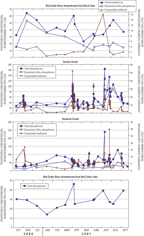
The average total phosphorus concentration in Sucker Creek was 56 µg/L (median concentration of 51 µg/L). Concentrations increased during high-flow events; concentrations over 100 µg/L were measured in April, July and August (fig. 10). About 60 percent of the phosphorus was in the dissolved form, with dissolved phosphorus concentrations over 60 µg/L measured in July and August. Suspended sediment concentrations generally were low (less than 10 mg/L); concentrations exceeded 20 µg/L only during high-flow events. The average particulate phosphorus content (particulate phosphorus concentration divided by the suspended sediment concentration) was about 3,000 micrograms per gram (µg/g). This value is high compared to other streams in the state (LaLiberte and Kampa, 1999).
The average total phosphorus concentration in Hemlock Creek was 56 µg/L (median concentration of 52 µg/L). Concentrations increased little during high-flow events, except during the early part of some events (fig. 10). During the first part of the events in late May and July, concentrations were over 100 µg/L. About 45 percent of the phosphorus was in the dissolved form. Suspended sediment concentrations generally were low (less than 10 mg/L); concentrations exceeded 20 µg/L only during a high-flow event in August. The average particulate phosphorus content was about 9,000 µg/g. This extremely high particulate phosphorus content compared to other streams in the state may be the result of the impounded water upstream of the gage trapping most of the mineralized sediment entering the stream.
The water-quality data and 15-minute-interval flow values were used to compute the total loadings of phosphorus and suspended sediment from these gaged tributaries and estimate the total monthly surface-water phosphorus loading to each lake during the 1-year study period (table 5). Approximately 5,390 lb of phosphorus were exported from Birch Lake to Balsam Lake (gaged). The highest monthly export (over 1,630 lb) was estimated in April. Approximately 1,070 lb of phosphorus were delivered from Sucker Creek (gaged) to the North Basin of Red Cedar Lake (0.141 lb/acre). Over half of the phosphorus was exported from Sucker Creek in April and about 75 percent was exported between April and June. Approximately 234,000 lb of suspended sediment were delivered from Sucker Creek (30.7 lb/acre). Approximately 2,300 lb of phosphorus were delivered from Hemlock Creek (gaged) to Hemlock Lake (0.176 lb/acre). The monthly exports of phosphorus from Hemlock Creek were more uniform than from Sucker Creek. Approximately 206,000 lb of suspended sediment were delivered from Hemlock Creek (15.8 lb/acre).
Phosphorus loading associated with surface-water inflow from all ungaged areas was estimated using the unit-area phosphorus yield determined for Sucker Creek. The unit-area yields from Sucker Creek watershed were used because this watershed is more similar to the other ungaged areas than is the Hemlock Creek watershed. The Hemlock Creek watershed contains more wetlands, impounded flow, and less agricultural areas than the ungaged areas. The unit-area yield for Sucker Creek (0.141 lb/acre) was multiplied by the total ungaged area (15,857 acres) to determine the loading from all ungaged areas. The total annual phosphorus loading from ungaged surface-water inflow to the Red Cedar Lakes was approximately 2,230 lb (table 5). Phosphorus loadings from ungaged inflows to the individual lakes/basins are given in table 5.
A large component of the phosphorus budget of the individual lakes/basins is associated with flow from the adjacent upstream lake/basin. The total annual transfer of phosphorus from the adjacent upstream lake/basin was computed from the product of the estimated annual flow (described in the previous section) and the average-annual, near-surface, phosphorus concentration measured in the lake. The average-annual concentration was computed from the measured monthly concentrations (concentrations for months without measurements were obtained by linearly interpolating between measured concentrations). Approximately 4,850 lb of phosphorus was transferred from Balsam Lake to the North Basin of Red Cedar Lake (table 5), 7,000 lb of phosphorus was transferred from the North Basin to the South Basin of Red Cedar Lake, and 4,090 lb was transferred from Hemlock Lake to the South Basin of Red Cedar Lake. Therefore, the South Basin of Red Cedar Lake receives a total of approximately 11,100 lb of phosphorus from the upstream adjacent lakes/basins (table 5).
Phosphorus loading from ground water to each of the lakes/basins was computed from the estimated daily ground-water flows described in the Water Budget section (based on the length of shoreline) and an estimated constant phosphorus concentration. The estimated constant total phosphorus concentration in ground water (25 µg/L) was based on the concentrations measured at Sucker and Hemlock Creeks during base-flow periods when flow mostly was from ground-water discharge to the streams (fig. 10). The daily ground-water loads of phosphorus then were computed as the product of daily average flow and 25 µg/L. The annual input of phosphorus from ground water was 2,450 lb. The annual and monthly phosphorus loads into the individual lakes/basins are given in table 5.
Only one documented "point" source of phosphorus is in the Red Cedar Lakes drainage basin: seepage out of the Birchwood Sewage-Disposal Pond. Effluent from this site is placed into a ground-water seepage pond about 0.5 mi east of Balsam Lake. Annual effluent to this pond is approximately 63.5 acre-ft with an average concentration of about 6 mg/L, or approximately 1000 lb/yr (P. Prusak, Wisconsin Department of Natural Resources Engineer, Cumberland, Wisconsin, oral commun., 2002). If it is assumed that 20 percent of this input is not retained by the soil, then 207 lb of phosphorus may reach Balsam Lake (table 5).
The input of phosphorus from septic systems (M) was estimated by use of equation 5 (Reckhow and others, 1980):
M = ES • (number of capita years) • (1 – SR),(5)
where M is a function of an export coefficient, ES, and a soil retention coefficient, SR. In applying equation 5, it was assumed that the most likely value for ES was 1.54 lb (0.7 kilogram) of phosphorus per capita per year. Typical export coefficients range from 1.1 lb per capita per year (Reckhow and others, 1980; Panuska and Kreider, 2002) to 1.8 lb per capita per year (Garn and others, 1996). The total number of capita years was estimated to be 530 (88 full-year households assumed to have 2 people and 354 3-month households assumed to have 4 people within 500 ft of the Red Cedar Lakes; table 6). The estimated number of capita years for each lake is given in table 6. It was assumed based on the soil conditions that the most likely value of SR was 0.7 (70-percent retention of phosphorus by the soil). The total annual input from septic tanks then was computed to be 245 lb (table 5). Because inputs from septic systems were not measured directly, low and high estimates were obtained by applying high and low estimates for SR (0.9 and 0.5). The possible low and high estimates of phosphorus from septic systems were 82 and 410 lb, respectively. Monthly loadings from septic systems into each lake/basin were assumed to be constant (table 5).
[Number of homes on each lake were obtained from E. Lund, Cedar Corporation, written commun., 2002]
| Lake/Basin | Total households | Full-time households | People per full-time household | Quarter-time households | People per quarter-time household | Capita years |
|---|---|---|---|---|---|---|
| Balsam Lake | 52 | 10 | 2 | 42 | 4 | 62 |
| Hemlock Lake | 42 | 8 | 2 | 34 | 4 | 50 |
| Red Cedar Lake | 348 | 70 | 2 | 278 | 4 | 418 |
| Red Cedar - North Basin | 174 | 35 | 2 | 139 | 4 | 209 |
| Red Cedar - South Basin | 174 | 35 | 2 | 139 | 4 | 209 |
| Red Cedar Lakes | 442 | 88 | 2 | 354 | 4 | 530 |
Phosphorus concentrations in the water leaving the lake, which were measured approximately monthly, varied little seasonally. Concentrations in the outflow ranged from 14 to 46 µg/L (fig. 10) and were similar to surface concentrations measured in the lake. The average total phosphorus concentration leaving Red Cedar Lake was 29 µg/L (median concentration of 28 µg/L). Daily phosphorus concentrations were obtained by linearly interpolating between measurements. The total output of phosphorus from Red Cedar Lake was estimated to be 10,200 lb; about 50 percent was exported between April and June.
The total input of phosphorus to the Red Cedar Lakes during this 1-year study period was 14,100 lb (table 5). The major source of phosphorus was from the gaged and ungaged tributaries that collectively contributed almost 80 percent of the total (table 5 and fig. 11). This load was almost equally divided between that coming from Birch Lake and that from the area directly draining into the lakes (Sucker Creek, Hemlock Creek, and ungaged areas). Just over half of this load was delivered to the lake between April and June. Loading was relatively uniform throughout the watershed; the yield from areas with minimal anthropogenic impact was similar to that from areas affected by agriculture. Ground water was estimated to contribute 17 percent of the load. Precipitation, seepage from the Birchwood Sewage-Disposal Pond, and septic systems were only minor contributors of phosphorus. Nearshore septic systems were estimated to have contributed between 0.6 and 2.9 percent of the total phosphorus input, depending on the assumptions on soil retention of phosphorus. Of the 14,100 lb of phosphorus that entered the lake during the 1-year period, about 10,200 lb (72.4 percent) were exported out of the lake; the remaining almost 3,900 lb were deposited in the lake-bed sediment. Precipitation during the study period was about 25 percent higher than normal; therefore, runoff and the estimated load were higher than would be expected in a year with normal precipitation.
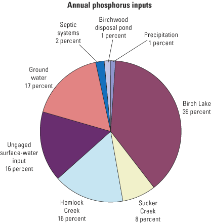
The contributions of phosphorus to each of the individual lakes/basins are given in table 5. For each of the lakes/basins, the relative contributions from individual sources were similar to that found for the Red Cedar Lakes as a whole (fig. 11). The main difference was that for some lakes/basins, the main source was transport from the adjacent upstream lake/basin. For example, the North Basin of Red Cedar Lake received 4,850 lb of phosphorus from Balsam Lake, and the South Basin received 11,100 lb collectively from the North Basin of Red Cedar Lake and from Hemlock Lake.
Phosphorus that is deposited in the lake-bed sediments is not permanently removed from the lakes and may be released back into the water column. The rate of phosphorus release from sediments is increased greatly when the sediment-water interface becomes anoxic (Wetzel, 1983), such as in the hypolimnion of all of the Red Cedar Lakes except the South Basin of Red Cedar Lake. Phosphorus released from hypolimnetic sediments typically results in a steady increase in phosphorus concentrations above the sediment-water interface after the onset of anoxia. This increase consistently was observed near the bottom in Balsam Lake, Hemlock Lake, and the North Basin of Red Cedar Lake during late summer and occasionally observed in Balsam and the North Basin of Red Cedar Lake in winter.
To quantify the internal loading of phosphorus in each basin, the accumulation of phosphorus in the hypolimnion was computed during summer stratification in 2001. The phosphorus accumulation during late winter was not quantified, but would be less than that estimated for summer stratification because near-bottom dissolved oxygen concentrations were higher and total phosphorus concentrations were lower than in the summer. In winter 2001, only Balsam Lake had a appreciable phosphorus accumulation. Total phosphorus accumulation in the hypolimnion was computed as the phosphorus mass in the hypolimnion in late summer (using detailed phosphorus profiles collected in August and September before the breakdown of stratification and morphometric data for each lake/basin) minus the phosphorus mass in the hypolimnion in May at the onset of stratification. It was assumed that phosphorus concentrations changed linearly with depth between vertical phosphorus measurement intervals, that the total accumulation from internal loading only occurred below the ther-mocline, and that phosphorus export from the hypolimnion to the epilimnion during summer and from bed sediments in oxic areas of the lake were small. The net accumulations of phosphorus in the hypolimnia were 1,280 lb for Balsam Lake, 480 lb for Hemlock Lake, 2,790 lb for the North Basin of Red Cedar Lake, and 118 lb for the South Basin of Red Cedar Lake. The total internal loading to the Red Cedar Lakes was 4,660 lb. If this loading were considered additional phosphorus added to the lake, the total annual loading would increase to about 18,700 lb, of which internal loading would represent about 25 percent. About 8,660 lb then would be retained in the Red Cedar Lakes (total input minus that exported from the lake). Therefore, the net annual result still is a loss of about 4,000 lb to the sediment. The contributions from the sediments can, however, drive seasonal productivity, such as fall algal blooms that may occur shortly after thermal stratification breaks down and the phosphorus that was accumulating in the hypolimnion is mixed into the entire water column.
Phosphorus release from the sediments is not expected to have a major effect on summer productivity because most of the internal phosphorus release is in late summer. Most of the loading from the watershed, however, is delivered when stratification is being established (during April though June when concentrations of almost all sources are about 30-50 µg/L). This range in concentration is relatively similar to that measured in the lakes during this period. Phosphorus release from the sediment could, however, have a larger effect on phosphorus concentrations (proportionally) in the lakes if external phosphorus loading is reduced. If external phosphorus loading was reduced, phosphorus release from the sediments would not be expected to decrease immediately, therefore, the internal loading would be higher (relative to external loading) for a few years and may result in higher in-lake phosphorus concentrations than expected given the external phosphorus loading.
The total external phosphorus input to the Red Cedar Lakes was estimated to be 14,100 lb in WY2001. One way to determine how much of this phosphorus would need to be eliminated to improve the present water quality of the lakes or to determine how increases in phosphorus loading would degrade water quality is by the use of empirical models that relate phosphorus loading to measured water quality. These models were developed on the basis of comparisons of hydrologic and phosphorus loading estimates determined for many different watershed/lake systems to specific measures describing lake-water quality, such as near-surface phosphorus and chlorophyll a concentrations, and Secchi depth. Some of these empirical models are contained within BATHTUB (Walker, 1996), and WiLMS (Panuska and Kreider, 2002). The BATHTUB model has hydrologic transport algorithms and is, therefore, capable of simulating changes in water quality in complex lakes (multi-basin lakes or lakes connected by short channels), whereas WiLMS is more suited for simulating changes in single-basin lakes. Therefore, to predict the expected changes in the water quality of the Red Cedar Lakes that should occur with changes in phosphorus loading, BATHTUB was applied to the entire system using the most applicable empirical model for each water-quality constituent. To determine if this response would vary if other models were used, some of the models within WiLMS also were applied to each of the individual lakes. When applying WiLMS, the two basins in Red Cedar Lake were treated collectively as one lake.
To predict the expected changes in water quality in the Red Cedar Lakes in response to changes in phosphorus loading, nine scenarios were simulated with BATHTUB: the conditions in 2001 (base case with which to compare other simulations), six basin-wide strategies (decreases in total external loading by 50, 25, and 10 percent and increases in total external phosphorus loading by 10, 25, and 50 percent, including that from ground water and septic input), and two additional specific scenarios with decreased phosphorus loads. The two specific phosphorus reduction scenarios were Scenario A—elimination of phosphorus inputs associated with Birchwood Sewage-Disposal Pond, private septic systems, and tributaries downstream of Birch Lake and the Hemlock Creek gage, and Scenario B—only the removal of inputs from the Birchwood Sewage-Disposal Pond and private septic systems. Scenario A represents the maximum reduction if all phosphorus that is directly input into the Red Cedar Lakes from septic systems and tributaries were eliminated (assumes phosphorus input from tributaries upstream from Balsam Lake and Hemlock Lake, ground water, and from precipitation remained unchanged). Only three scenarios were simulated with WiLMS: the conditions in 2001, and a 50-percent decrease and 50-percent increase in total external loading. Because the lakes are believed to be primarily phosphorus limited, only alterations to phosphorus loads were simulated.
Four types of data are required as input to these models for each lake/basin: morphometric data (table 1), water-quality data (table 3), hydrologic data (table 4), and nutrient-loading data for each source (table 5) . The time period for the hydrologic and nutrient loading used in the BATHTUB model is dependent on the phosphorus-turnover ratio (number of times the phosphorus mass in the lake is replaced in a specific time period). The model should be run for a period that results in a phosphorus-turnover ratio greater than 2. Annual simulations resulted in the phosphorus turnover ratios for each lake between 4.7 (North Basin of Red Cedar Lake) and 16.0 (Hemlock Lake) (table 1) and 5.0 for the four basins as a whole. Therefore, nutrient-loading data were summarized over the entire period from October 1, 2000, through September 30, 2001, and water-quality data for the basins/lakes were averaged from May through September. Even though loading data are summarized for the entire year, the model simulates water quality only for the growing season (May through September). The models within WiLMS all use annual hydrologic and phosphorus loadings, but simulate the water quality for different discrete seasons (described later). Phosphorus from internal loading (sediment release) was not included as a phosphorus source for BATHTUB and WiLMS because most empirical models already incorporate this source and only should be added when a lake/reservoir has abnormally high internal loading (W. Walker, Jr., U.S. Army Corps of Engineers, oral commun., 2002).
In applying BATHTUB, the dispersion coefficient for each basin (exchange of water with the adjacent upstream basin/lake) and the specific algorithms to simulate each water-quality constituent must be defined. The algorithms chosen to simulate total phosphorus and chlorophyll a concentrations are listed in table 7, all of which are default algorithms and applicable to most lakes and reservoirs. Non-algal turbidity factors (or the reduction in clarity caused by factors other than algae) were computed within BATHTUB. Calibration coefficients for each water-quality constituent may be applied for each lake/basin. The coefficients applied in simulating the Red Cedar Lakes are given in table 8. All of these coefficients are within the typical range applied for most lakes, except that for phosphorus in Balsam Lake. One possible explanation for the large calibration coefficient required to accurately simulate the phosphorus concentrations in Balsam Lake may be that the lake has a relatively short residence time (just over 1 month) and had total phosphorus concentrations entering the lake during May through September that were lower than other times of the year. The model is capable of only simulating one time period for the entire system, which, in this case, was 1 year. The 1-year period was needed because of the long residence time in the North Basin of Red Cedar Lake (over 4 months; table 1). Another possibility for the large calibration coefficient may be that the water entering from Birch Lake (from the bottom withdrawal dam) was cooler than Balsam Lake water and continuously sank below the epilimnion in the lake. Therefore, this loading did not affect near-surface phosphorus concentrations as much as it would have if the water did not sink. There are no calibration factors in WiLMS; however, the output can be adjusted to account for model biases by only interpreting the results as a percentage change from present conditions (described in detail later).
Table 7. Algorithms used within BATHTUB to simulate water quality in Red Cedar Lakes, Wisconsin
| Process | Algorithm number | Algorithm description |
|---|---|---|
| Phosphorus balance | 1 | Second order, available phosphorus |
| Nitrogen balance | 0 | Not computed |
| Chlorophyll a concentration | 2 | Function of phosphorus, light, and temperature |
| Secchi depth | 1 | Function of chlorophyll a and turbidity |
| Dispersion | 1 | Fisher numeric |
| Phosphorus calibration | 1 | Decay rates |
| Nitrogen calibration | 0 | None |
Table 8. Calibration coefficients used in BATHTUB simulations of the Red Cedar Lakes, Wisconsin
| Lake/Basin | Total phosphorus | Chlorophyll a | Secchi depth |
|---|---|---|---|
| Balsam Lake | 3.0 | 0.85 | 1.0 |
| Red Cedar - North Basin | .6 | 1.00 | 1.0 |
| Red Cedar - South Basin | 1.0 | 1.00 | 1.0 |
| Hemlock Lake | 2.0 | .85 | 1.0 |
To simulate the effects of basin-wide changes in phosphorus loading, the average volumetrically weighted total and dissolved ortho-phosphorus concentrations (total nutrient load divided by total water load) for each of the sources were decreased and increased by 50, 25, and 10 percent. To determine the response in water quality (total phosphorus, chlorophyll a and Secchi depth) to eliminating specific nutrient sources, the phosphorus concentrations for the eliminated sources were set to near 0 µg/L (0.1 µg/L). Nitrogen concentrations were not altered in the various phosphorus-loading scenarios. Because the lakes/basins are phosphorus limited, altering nitrogen concentrations was shown to have little effect on the simulated results.
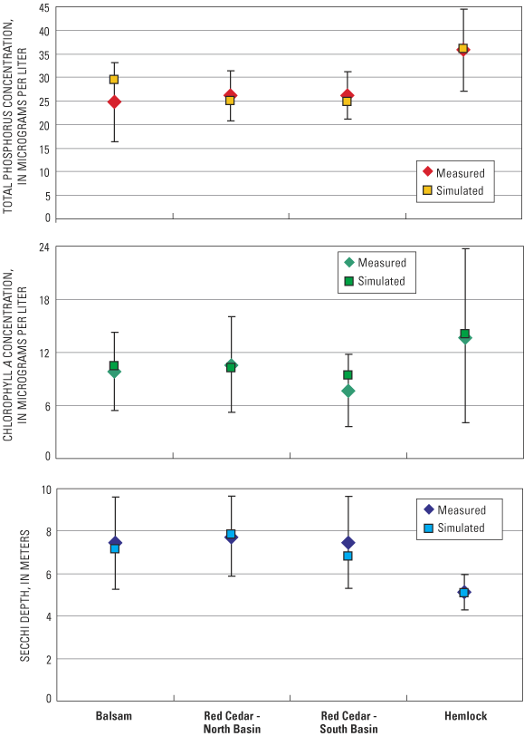
With the loading data from WY2001, BATHTUB was used to simulate the summer average water quality (May through September) in each lake/basin. The simulated values are compared with the measured values in the lakes/basin in 2001 (table 3) in figure 12. The coefficient of variation was computed for each measured value (on the basis of the monthly data) and used to calculate an estimate of the certainty (plus and minus one standard error around the average). After model calibration, BATHTUB accurately simulated total phosphorus (within ± 5 µg/L), chlorophyll a (within ± 2 µ/L), and Secchi depths (within ± 0.7 ft) in all of the lakes/basins for 2001.
On the basis of BATHTUB model simulations, phosphorus concentrations in each of the lakes/basins have a relatively linear response to a linear change in phosphorus loading (fig. 13); however, on a percentage basis, the changes in phosphorus concentrations are not as large as the changes in phosphorus loadings. Changes in phosphorus concentrations are about 60–70 percent of the changes in phosphorus loading. In other words, a 50-percent increase in phosphorus loading causes a 30–35-percent increase in phosphorus concentrations. This relation results in a larger absolute change in phosphorus concentration in Hemlock Lake for a given percent change in nutrient loading than the other lakes/basins because Hemlock Lake presently has the highest phosphorus concentration.
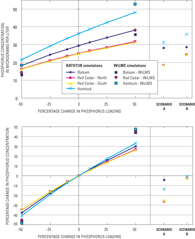
In response to Scenario A (elimination of all phosphorus input from the Birchwood Sewage-Disposal Pond, private septic systems, and tributary inputs downstream of Birch Lake and the Hemlock Creek gage), phosphorus concentrations change little in Balsam Lake, decrease by about 15 percent in Hemlock Lake, and decrease by about 30 percent in Red Cedar Lake. Most of the phosphorus reductions in Scenario A are associated with the reduction in nearby surface-water contributions, of which Balsam Lake has the least (other than that from Balsam Lake that was not reduced) and Red Cedar Lake has the most. Phosphorus inputs associated with the sewage-disposal pond and private septic systems are small compared to other sources; therefore, elimination of these sources (Scenario B) has little effect on the water quality of the lakes.
Chlorophyll a concentrations also have a relatively linear response to a linear change in phosphorus loading, except for high phosphorus-loading scenarios where there is a smaller percentage response (fig. 14). Changes in chlorophyll a concentrations are about 80–100 percent of the changes in phosphorus loading; however, with loadings greater than 25 percent, the increase only is between 50 and 80 percent of the increase in phosphorus loading. Chlorophyll a concentrations in Hemlock Lake again are most responsive to changes in phosphorus loading on the basis of concentration; however, the changes are similar on a percentage basis.
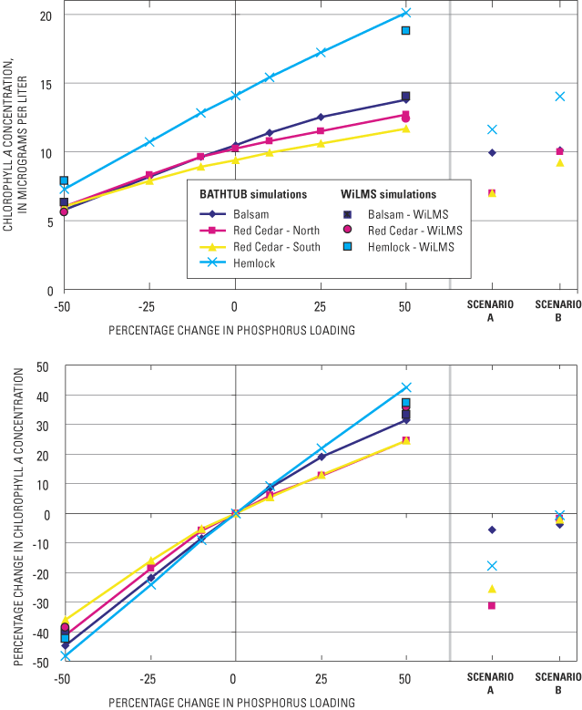
Changes in phosphorus loading with Scenario A has almost no effect on chlorophyll a concentrations in Balsam Lake, about a 15-percent decrease in chlorophyll a concentrations in Hemlock Lake, and about a 30-percent decrease in chlorophyll a concentrations in Red Cedar Lake. These percent changes are similar to those for total phosphorus concentrations. Elimination of phosphorus inputs associated with the sewage-disposal pond and private septic systems (Scenario B) has little effect on chlorophyll a concentrations in any of the lakes.
Water clarity is more responsive to decreases in phosphorus loading than to increases in loading (fig. 15). With a decrease in phosphorus loading of 50 percent, Secchi depths increase about 2–3 ft (20–40 percent); however, with a 50-percent increase in loading, Secchi depths only decrease by about 1 ft (10–20 percent). With Scenario A, Secchi depths increase about 2 ft (25 percent) in Red Cedar Lake and increase by about 1 ft in Hemlock Lake, but do not change in Balsam Lake. No changes in Secchi depths result in any of the lakes with Scenario B.
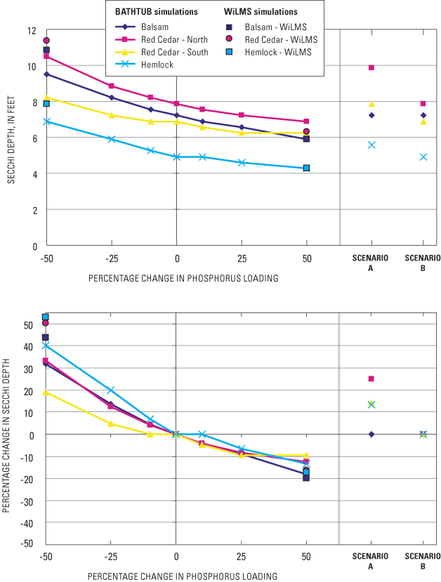
Trophic state index values indicate that Balsam Lake and Red Cedar Lake presently are borderline mesotrophic to eutrophic (mesotrophic with respect to Secchi depth and eutrophic with respect to phosphorus and chlorophyll a) and Hemlock Lake is eutrophic with respect to all three characteristics (fig. 6). On the basis of simulation results from BATHTUB, about a 50-percent reduction in phosphorus loading from that measured in WY2001 would be required for all three lakes to be classified as mesotrophic with respect to all three characteristics (fig. 16). The 50-percent reduction is needed for Hemlock Lake to be classified as mesotrophic with respect to its Secchi Depth; the other lakes already are classified as mesotrophic with respect to their Secchi depths. With Scenario A, changes in the water quality of Red Cedar Lake should result in it being classified as mesotrophic; however, the other lakes should remain eutrophic. Removal of all phosphorus from the sewage-disposal pond and private septic systems (Scenario B) should have little effect on the trophic state of any of the lakes.
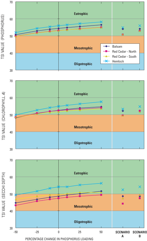
All of the above model simulations were based on changes in the average water quality during the growing season (May–September). However, often what is perceived as the biggest problem is the extremes in water quality, for example, algal blooms. The definition of what constitutes the occurrence of an algal bloom can be site specific and subjective. In what typically is a clear lake, it may be considered that the lake has an algal bloom when the lake has a slight green color, whereas for a typically productive lake, it may considered that the lake has an algal bloom only when it is very green. A chlorophyll a concentration of 10 µg/L represents a small amount of algae in a water body, whereas a concentration of 60 µg/L represents an extremely severe algal bloom. A chlorophyll a concentration of 30 µg/L represents what many would consider a moderate algal bloom. Results from BATHTUB simulations are used to demonstrate how the occurrence of algal blooms in each of the lakes (percent of days from May through September with a chlorophyll a concentration exceeding a certain value) should respond to variable phosphorus loadings as a function of how an algal bloom is defined (chlorophyll a concentrations from 10 to 40 µg/L) (fig. 17). Results for Red Cedar Lake are only shown for the North Basin because the results for the North and South Basins were similar. These results are summarized in table 9.
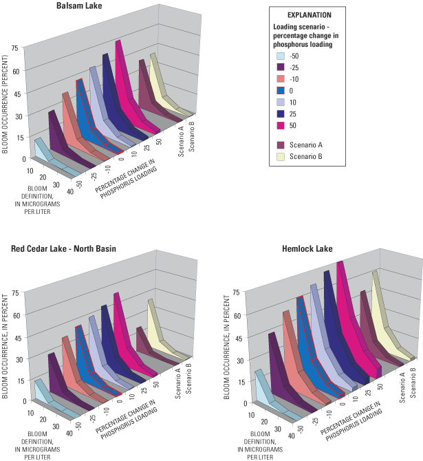
[Algal blooms defined as chlorophyll a concentrations greater than (>) 10, 20, 30, and 40 micrograms per liter (µg/L); %, percent. Scenario A represents the elimination of phosphorus inputs from the Birchwood Sewage-Disposal Pond, private septic systems, and tributaries downstream of Birch Lake and the Hemlock Creek gage. Scenario B represents only the removal of phosphorus inputs from the Birchwood Sewage-Disposal Pond and private septic systems.]
| Change in Phosphorus Loading/Scenario | Percentage of days (from May through September) with algal blooms in indicated lake/basin | ||
|---|---|---|---|
| Balsam Lake | Red Cedar North Basin | Hemlock Lake | |
| Chlorophyll a > 10 µg/L | |||
| -50% | 11.5 | 12.7 | 20.6 |
| -25% | 26.7 | 27.3 | 42.2 |
| -10% | 35.4 | 35.3 | 53.5 |
| 0% | 40.8 | 39.1 | 59.6 |
| 10% | 46.1 | 42.5 | 64.9 |
| 25% | 51.8 | 46.9 | 71.4 |
| 50% | 58.3 | 52.9 | 79.2 |
| Scenario A | 37.3 | 18.9 | 47.4 |
| Scenario B | 38.7 | 37.7 | 59.1 |
| Chlorophyll a > 20 µg/L | |||
| -50% | 1.0 | 1.2 | 2.6 |
| -25% | 4.1 | 4.3 | 9.4 |
| -10% | 6.8 | 6.7 | 15.1 |
| 0% | 8.8 | 8.1 | 19 |
| 10% | 11.2 | 9.5 | 23.1 |
| 25% | 14.2 | 11.6 | 29 |
| 50% | 18.2 | 14.8 | 38 |
| Scenario A | 7.5 | 2.3 | 11.8 |
| Scenario B | 8. | 7.6 | 18.8 |
| Chlorophyll a > 30 µg/L | |||
| -50% | 0.1 | 0.2 | 0.5 |
| -25% | .8 | .9 | 2.4 |
| -10% | 1.6 | 1.6 | 4.6 |
| 0% | 2.3 | 2.0 | 6.3 |
| 10% | 3.1 | 2.5 | 8.2 |
| 25% | 4.2 | 3.2 | 11.4 |
| 50% | 5.9 | 4.5 | 16.9 |
| Scenario A | 1.8 | .4 | 3.3 |
| Scenario B | 2. | 1.8 | 6.2 |
| Chlorophyll a > 40 µg/L | |||
| -50% | 0.0 | 0.0 | 0.1 |
| -25% | .2 | .2 | .7 |
| -10% | .5 | .4 | 1.6 |
| 0% | .7 | .6 | 2.3 |
| 10% | 1. | .8 | 3.2 |
| 25% | 1.4 | 1. | 4.7 |
| 50% | 2.1 | 1.5 | 7.7 |
| Scenario A | .5 | .1 | 1.1 |
| Scenario B | .6 | .5 | 2.2 |
On the basis of BATHTUB simulations, algal blooms (as defined by chlorophyll a concentrations greater than 30 µg/L) are relatively uncommon, and only occur on about 6 percent of the days between May and September in Hemlock Lake and less than this percentage in the other lakes. However, if phosphorus loading increases by 50 percent, algal blooms in Hemlock would increase to about 17 percent of the days and to about 5–6 percent of the days in the other lakes. With a 50-percent decrease in loading, an algal bloom of this magnitude would occur on less than 1 percent of the days in any of the lakes. Algal blooms defined as chlorophyll a concentrations greater than 40 µg/L rarely occur presently, but would become more common in Hemlock Lake (7 percent of the days) with increases in nutrient loading of 50 percent. The response in the percentage of days with algal blooms, based on any definition, is relatively linear with respect to a linear change in phosphorus loading, except with load reductions greater than 25 percent. Reductions in loading by more than 25 percent cause a larger change in the frequency of algal blooms than for any other incremental change in phosphorus loading.
Algal blooms defined as chlorophyll a concentrations greater than 10 µg/L or greater than 20 µg/L have a much larger response to changes in phosphorus loading than if defined by greater than 30 and 40 µg/L. A 50-percent reduction in phosphorus loading into Red Cedar Lake would decrease the percentage of days with chlorophyll a concentrations greater 10 µg/L from about 40 percent of the days currently to about 13 percent of the days, and the percentage of days with chlorophyll a concentrations greater than 20 µg/L would decrease from 8 percent to 1 percent. A 50-percent increase in loading would increase the occurrence of algal blooms with concentrations greater than 10 µg/L to about 53 percent of the days and to 15 percent of the days with concentrations greater than 20 µg/L. Responses in algal blooms to loading changes for Balsam Lake are similar to those for Red Cedar Lake; however, algal blooms are more responsive in Hemlock Lake than in Red Cedar Lake.
Changes in the occurrence of algal blooms with Scenario A would be similar to that for a 10-percent reduction phosphorus loading in Balsam Lake, a 35-percent reduction in Red Cedar Lake, and a 15- to 20-percent reduction in Hemlock Lake. There would be little change in the occurrence of algal blooms in any of the lakes with Scenario B.
To determine how the response in water quality (total phosphorus, chlorophyll a and Secchi depth) varies with respect to changes in phosphorus loading if other models were used, some of the models within WiLMS (Panuska and Kreider, 2002) were also applied to each of the lakes (the two basins in Red Cedar Lake were treated collectively as one lake), but only for a subset of the scenarios. Of the 13 models contained in WiLMS, 9 of the models were applicable to the hydrologic systems of Balsam Lake and Red Cedar Lake and 8 were applicable to the hydrologic system of Hemlock Lake. Therefore, the morphometry of the lakes and the hydrology and phosphorus loadings for WY2001 first were input into these models to simulate near-surface phosphorus concentrations. When simulating the water quality in Red Cedar Lake, the transfer of water and phosphorus from Balsam and Hemlock Lakes (tables 4 and 5) were included. An increase and decrease in total external phosphorus loading by 50 percent then were input into these models to simulate the expected changes in near-surface phosphorus concentrations. Each of the models within WiLMS uses annual hydrologic and phosphorus loads, but simulates an average phosphorus concentration for a specific season (table 10). For each lake, all eight or nine models were applied and their results were then averaged and compared with those simulated with BATHTUB (figs. 14–16).
[%, percent; >, greater than; <, less than; NA, model not applicable]
| Measured | Simulated | ||||
|---|---|---|---|---|---|
| Lake Phosphorus Model (Type of lakes that the model was developed from) | Prediction season | Seasonal concentration | 2001 | 50% reduction in phosphorus loading | 50% increase in phosphorus loading |
| Balsam Lake | |||||
| Canfield and Bachman, 1981 (Natural lakes) | Spring | 37.0 | 31.0 | 16.0 | 45.0 |
| Canfield and Bachman, 1981 (Artificial lakes) | Spring | 37.0 | 27 | 15 | 38 |
| Rechow, 1979 (General lakes) | Growing season | 24.8 | 32 | 16 | 47 |
| Rechow, 1977 (Anoxic lakes) | Growing season | 24.8 | 39 | 19 | 58 |
| Rechow, 1977 (Water load >165 feet per year) | Growing season | 24.8 | 30 | 15 | 44 |
| Vollenweider, 1982 (General lakes) | Annual | 30.4 | 27 | 15 | 38 |
| Vollenweider, 1982 (Shallow lakes) | Annual | 30.4 | 22 | 12 | 31 |
| Walker, 1977 (General lakes) | Spring | 37.0 | 33 | 17 | 50 |
| Walker, 1985 (Reservoirs) | Growing season | 24.8 | 29 | 17 | 38 |
| Average | 30.1 | 30.0 | 15.8 | 43.2 | |
| Change, µg/L | -14.2 | 13.2 | |||
| Change, percentage from Base Scenario | -47.4% | 44.1% | |||
| Red Cedar Lake | |||||
| Canfield and Bachman, 1981 (Natural lakes) | Spring | 37.0 | 24 | 13 | 35 |
| Canfield and Bachman, 1981 (Artificial lakes) | Spring | 37.0 | 21 | 12 | 29 |
| Rechow, 1979 (General lakes) | Growing season | 26.2 | 21 | 11 | 32 |
| Rechow, 1977 (Anoxic lakes) | Growing season | 26.2 | 31 | 16 | 47 |
| Rechow, 1977 (Water load <165 feet per year) | Growing season | 26.2 | 22 | 11 | 32 |
| Vollenweider, 1982 (General lakes) | Annual | 28.0 | 20 | 12 | 29 |
| Vollenweider, 1982 (Shallow lakes) | Annual | 28.0 | 16 | 9 | 23 |
| Walker, 1977 (General lakes) | Spring | 37.0 | 24 | 12 | 37 |
| Walker, 1985 (Reservoirs) | Growing season | 26.0 | 21 | 13 | 27 |
| Average | 30.2 | 22.2 | 12.1 | 32.3 | |
| Change, µg/L | -10.1 | 10.2 | |||
| Change, percentage from Base Scenario | -45.5% | 45.5% | |||
| Hemlock Lake | |||||
| Canfield and Bachman, 1981 (Natural lakes) | Spring | 41.0 | 28 | 14 | 41 |
| Canfield and Bachman, 1981 (Artificial lakes) | Spring | 41.0 | 25 | 13 | 35 |
| Rechow, 1979 (General lakes) | Growing season | 35.8 | 24 | 12 | 36 |
| Rechow, 1977 (Anoxic lakes) | Growing season | 35.8 | 34 | 17 | 51 |
| Rechow, 1977 (Water load <165 feet per year) | Growing season | 35.8 | 24 | 12 | 36 |
| Vollenweider, 1982 (General lakes) | Annual | 44.8 | 25 | 14 | 35 |
| Vollenweider, 1982 (Shallow lakes) | Annual | 44.8 | 20 | 11 | 29 |
| Walker, 1977 (General lakes) | Spring | 41.0 | 30 | 15 | 46 |
| Walker, 1985 (Reservoirs) | Growing season | NA | NA | NA | NA |
| Average | 40.0 | 26.3 | 13.5 | 38.6 | |
| Change, µg/L | -12.8 | 12.4 | |||
| Change, percentage from Base Scenario | -48.6% | 47.1% | |||
The average simulated phosphorus concentration for Balsam Lake when all phosphorus inputs were included in the models was 30.0 µg/L. This value is similar to the average of the seasonally summarized data measured in the lake (30.1 µg/L, table 10). The models were then applied with the phosphorus load decreased and increased by 50 percent. With a 50-percent reduction in phosphorus loading, the average simulated phosphorus concentration was 15.8 µg/L (a decrease of 14.2 µg/L or 47.4 percent, table 10). With a 50-percent increase in phosphorus loading, the average simulated concentration was 43.2 µg/L (an increase of 13.2 µg/L or 44.1 percent). If it is assumed that these percentage changes also apply to the summer average concentration measured in Balsam Lake of 24.8 µg/L, then a 50-percent reduction in loading would result in a summer average concentration of 13.0 µg/L and a 50-percent increase in loading would result in a summer average concentration of 35.7 µg/L. This response is only slightly more than that simulated with BATHTUB (fig. 13).
Empirical relations have been developed to predict average summer chlorophyll a concentrations and Secchi depths from near-surface phosphorus concentrations. Relations developed for Wisconsin lakes by Lillie and others (1993), also contained within WiLMS, were applied to determine how the simulated changes in phosphorus concentration in the lake associated with decreases and increases in phosphorus loading should affect chlorophyll a concentrations and Secchi depths. When the average measured summer phosphorus concentration of 24.8 µg/L was input into the empirical relations, it was predicted that the lake should have a chlorophyll a concentration of 8.7 µg/L (compared to 9.8 µg/L measured during 2001) and a Secchi depth of 6.2 ft (compared to the measured 7.4 ft). The simulated average summer phosphorus concentrations for the 50-percent decrease and increase in phosphorus loading of 13.0 µg/L and 35.7 µg/L, respectively, were then input into the relations. For 13.0 µg/L of phosphorus, the empirical relations predicted a chlorophyll a concentration of 5.2 µg/L (a 40-percent reduction from the predicted 8.7 µg/L) and a Secchi depth of 9.19 ft (a 47-percent improvement from the predicted 6.2 ft). For 35.7 µg/L of phosphorus, the empirical relations predicted a chlorophyll a concentration of 11.6 µg/L (a 33-percent increase from the predicted 8.7 µg/L) and a Secchi depth of 4.9 ft (a 21-percent reduction from the predicted 6.2 ft).
If it is assumed that the empirical relations more accurately predict the percentage of change rather than absolute values, a 50-percent decrease in phosphorus loading results in chlorophyll a concentrations decreasing from the measured summer average of 9.8 µg/L to 5.9 µg/L and Secchi depth increasing from 7.4 ft to 11.0 ft. Applying the percentage of change to the measured summer average concentrations essentially results in site-specific calibration. A 50-percent increase in phosphorus loading then results in chlorophyll a concentrations increasing from 9.8 µg/L to 13.1 µg/L and Secchi depth decreasing from 7.4 ft to 5.9 ft. These changes were only slightly less than that simulated with BATHTUB for chlorophyll a and slightly more than that simulated for Secchi depth (figs. 14 and 15).
The average phosphorus concentration simulated for Red Cedar Lake with all phosphorus inputs included in the models was 22.2 µg/L, which is less than the average of the measured data (30.2 µg/L, table 10). With a 50-percent reduction in phosphorus loading, the average simulated phosphorus concentration was 12.1 µg/L (a decrease of 10.1 µg/L or 45.5 percent, table 10). With a 50-percent increase in loading, the average simulated concentration was 32.3 µg/L (an increase of 10.2 µg/L or 45.5 percent). If it is assumed that these percentage changes also apply to the summer average concentration (site-specific calibration) of 26.2 µg/L, then a 50-percent reduction in loading would result in a summer average concentration of 14.0 µg/L and a 50-percent increase in loading would result in 38.0 µg/L. This response is only slightly more (about 15 percent) than that simulated with BATHTUB (fig. 13).
The empirical models in WiLMS predicted that with the measured average summer phosphorus concentration of 26.2 µg/L, the lake should have a chlorophyll a concentration of 9.0 µg/L (compared to 9.1 µg/L, average measured in the North and South Basins, table 3) and a Secchi depth of 5.9 ft (compared to the measured 7.6 ft). For 14.0 µg/L of phosphorus, the relations predicted a chlorophyll a concentration of 5.5 µg/L (a 39-percent reduction from the predicted 9.0 µg/L) and a Secchi depth of 8.9 ft (a 50-percent increase from the predicted 5.9 feet). For 38 µg/L of phosphorus, the relations predicted a chlorophyll a concentration of 12.2 µg/L (a 36-percent increase) and a Secchi depth of 4.9 ft (a 17-percent reduction). If it again is assumed that the empirical relations are best used to predict the percentage of change, a 50-percent decrease in phosphorus loading should result in chlorophyll a concentrations decreasing from the measured summer average of 9.1 µg/L to 5.6 µg/L and average Secchi depth increasing from 7.6 ft to 11.4 ft. A 50-percent increase in phosphorus loading should result in the average chlorophyll a concentration increasing from 9.1 µg/L to 12.4 µg/L and Secchi depth decreasing from 7.6 ft to 6.3 ft. These changes are similar to those simulated with BATHTUB (figs. 14 and 15).
The average phosphorus concentration simulated for Hemlock Lake with all phosphorus inputs included in the models was 26.3 µg/L, less than the 40 µg/L measured in the lake (table 10). With a 50-percent reduction in phosphorus loading, the average simulated phosphorus concentration was 13.5 µg/L (a decrease of 12.8 µg/L or 48.6 percent). With a 50-percent increase in loading, the average simulated concentration was 38.6 µg/L (an increase of 12.4 µg/L or 47.1 percent). If it is assumed these percentage changes also apply to the summer average concentration of 35.8 µg/L, then a 50-percent reduction in loading would result in a summer average concentration of 18.4 µg/L and a 50-percent increase would result in 52.7 µg/L. This response is only slightly more than that simulated with BATHTUB (fig. 13).
The empirical relations in WiLMS predicted that, with the measured average summer phosphorus concentration of 35.8 µg/L, the lake should have a chlorophyll a concentration of 11.6 µg/L (compared to the measured 13.7 µg/L) and a Secchi depth of 4.9 ft (compared to the measured 5.2 ft). For the simulated 18.4 µg/L of phosphorus, the relations predicted a chlorophyll a concentration of 6.7 µg/L (a 42-percent reduction from the predicted 11.6 µg/L) and a Secchi depth of 7.6 ft (a 53-percent increase from the predicted 4.9 ft). For 52.7 µg/L of phosphorus, the relations predicted a chlorophyll a concentration of 15.9 µg/L (a 37-percent increase) and a Secchi depth of 3.9 ft (a 20-percent reduction). If it again is assumed that the relations best predict the percentage of change, a 50-percent decrease in phosphorus loading should result in chlorophyll a concentrations decreasing from the measured summer average of 13.7 µg/L to 7.9 µg/L and Secchi depth increasing from 5.2 ft to 7.9 ft. A 50-percent increase in phosphorus loading should result in chlorophyll a concentrations increasing from 13.7 µg/L to 18.8 µg/L and Secchi depth decreasing from 5.2 ft to 4.1 ft. These changes are similar to those simulated with BATHTUB (figs. 14 and 15).
Simulations with BATHTUB and WiLMS gave similar results for the expected response in water quality to changes in phosphorus loading. Total phosphorus and chlorophyll a, concentrations should increase almost linearly with a linear increase in phosphorus loading, but the changes in in-lake concentrations are not expected to be as large as the changes in phosphorus loadings. Results from WiLMS indicated a slightly larger response in total phosphorus concentrations but similar response in chlorophyll a concentrations. Results from both models indicated that water clarity should be more responsive to decreases in phosphorus loading than to increases in loading (fig. 15), although results from WiLMS indicated a slighter larger response to reductions in phosphorus loading than did those from BATHTUB.
Balsam Lake and Red Cedar Lake presently are classified as borderline mesotrophic to eutrophic (mesotrophic with respect to Secchi depth and eutrophic with respect to phosphorus and chlorophyll a), and Hemlock Lake is classified as eutrophic with respect to all three characteristics. Because of concerns that the water quality of these lakes was degrading, three cooperative studies were conducted by the USGS between 1993 and 2003. As part of these studies, water quality in the lakes was documented in 1993–94, 1996–97, and 2000–01. The goals of the final study were to evaluate the water quality of the lakes in terms of long-term trends (1980s to the present), to quantify the sources of phosphorus to the lakes, and to determine how the lakes would respond to changes in phosphorus loading. Little change in water quality has been measured in these lakes since data collection began on the lakes from 1987 (Red Cedar Lake) and 1993 (Balsam and Hemlock Lakes).
A water budget, constructed for WY2001, indicated that the major sources of water to the Red Cedar Lakes are from Birch Lake (36 percent), gaged and ungaged surface-water inflows (33 percent), and ground water (25 percent). Precipitation on the surface of the lakes contributed about 6 percent of the total inputs. The major output of water from the lakes was through the outlet of Red Cedar Lake (96 percent) and secondarily from evaporation (4 percent).
Phosphorus budgets also were constructed for WY2001. The total annual input of phosphorus to the Red Cedar Lakes was 14,100 lb. The major source of phosphorus was from the tributaries that collectively contributed almost 80 percent of the total. This load was almost equally divided between that coming from Birch Lake and that from areas directly draining into the lakes. Yields from direct surface-water inputs were relatively similar between areas with minimal anthropogenic impact and areas with agriculture. Ground water was estimated to contribute about 17 percent of the phosphorus load, whereas precipitation, loss from the Birchwood Sewage-Disposal Pond, and septic systems were only minor contributors. Of the 14,100 lb of phosphorus that entered the lake, about 10,200 lb (72.4 percent) were exported out of the lake; the remaining almost 3,900 lb were deposited in the lake sediments.
It was estimated that the sediments release about 4,660 lb of phosphorus during summer stratification; however, on an annual basis, the sediments accumulate phosphorus. Phosphorus release from the sediments is not expected to have a major effect on summer productivity because most of this phosphorus is not released to the upper part of the lake until late summer. This release could drive fall algal blooms.
Two water-quality models (BATHTUB and WiLMS) were used to simulate the expected changes in water quality in response to specific phosphorus-loading scenarios. These simulations determined how much of the phosphorus load would need to be eliminated to improve water quality and how increases in phosphorus loading would degrade the water quality of the lakes. Simulation results from both models indicated total phosphorus and chlorophyll a concentrations increase almost linearly with a linear increase in phosphorus loading, but changes in in-lake concentrations are not expected to be as large as the changes in phosphorus loadings. Simulation results from both models also indicated that water clarity is more responsive to decreases in phosphorus loading than to loading increases. About a 50-percent reduction in phosphorus loading is required for all three lakes to achieve a mesotrophic classification. Changes in phosphorus loading affect the percentage of days with algal blooms, especially the number of days with less extensive algal blooms.
Simulations of specific phosphorus-reduction strategies indicated that elimination of all tributary and septic inputs downstream of Birch Lake and the Hemlock Creek gage (Scenario A) would have little effect on the water quality of Balsam Lake, about a 15-percent decrease in phosphorus concentrations in Hemlock Lake, and about a 30-percent decrease in phosphorus concentrations in Red Cedar Lake. This limited effect occurs because most phosphorus entering the lakes comes from Birch Lake, ground water, and the relatively undeveloped land upstream of Hemlock Lake. Therefore, to attain appreciable improvements in the water quality of the Red Cedar Lakes would require that the water quality of the upstream lakes be improved. This agrees with the statement made by the WDNR (1997) that "phosphorus loading goals set for mainstem lakes (such as the Red Cedar Lakes) only can be attained if they are considered at the same time decisions are being made in upstream lakes and their drainage areas." Presently, Lake Chetac and Birch Lake are productive lakes and both are more eutrophic than the Red Cedar Lakes (based on Self-help monitoring data).
The effects of phosphorus-load reductions immediately after a load reduction are not expected to be as large as those simulated by the models because of phosphorus release from the sediments. Empirical models, such as those in BATHTUB and WiLMS, assume a typical internal phosphorus release for a lake with the specified external loading. Therefore, it is assumed in model simulations that the lake is in equilibrium with its external loading. However, if external phosphorus loading is reduced, internal loading would be expected to remain relatively high for several years. Therefore, phosphorus release from sediments of the Red Cedar Lakes could become relatively more important and possibly delay the anticipated effects of external phosphorus-load reductions.
Although a decrease in phosphorus loading from areas immediately adjacent to the Red Cedar Lakes by itself would only slightly improve the water quality of the lakes, increases in phosphorus loading from areas adjacent to the Red Cedar Lakes could appreciably degrade the water quality of the lakes. Suspended sediment in the tributaries was found to have a high particulate phosphorus content; therefore, any increase in erosion from the watershed could result in unusually high phosphorus loading to the lakes. Therefore, although the water quality of the Red Cedar Lakes has not changed appreciably in recent years, continuing efforts to protect the lake and its susceptible watershed are necessary to maintain the current water quality.
Canfield, D.E., and Bachmann, R.W., 1981, Prediction of total phosphorus concentrations, chlorophyll-a, and Secchi depths in natural and artificial lakes: Canadian Journal of Fisheries Aquatic Sciences, v. 38, p. 414–423.
Carlson, R.E., 1977, A trophic state index for lakes: Limnology and Oceanography, v. 22, p. 361–369.
Corell, D.L., 1998, The role of phosphorus in the eutrophication of receiving waters–A review: Journal of Environmental Quality, v. 27, p. 261–266.
Edwards, T.K., and Glysson, G.D., 1999, Field methods for measurement of fluvial sediment: U.S. Geological Survey Techniques of Water-Resources Investigations, book 3, chap. C2, 89 p.
Farnsworth, R.K., and Thompson, E.S., 1982, Average monthly, seasonal, and annual pan evaporation for the United States: National Oceanographic and Atmospheric Administration Report NWS 34. Washington, D.C., National Weather Service, 82 p.
Farnsworth, R.K., Thompson, E.S., and Peck, E.L., 1982, Evaporation atlas for the contiguous 48 United States: National Oceanographic and Atmospheric Administration Technical Report NWS 33. Washington, D.C.: National Weather Service, 26 p.
Fishman, M.J., Raese, J.W., Gerlitz, C.N., and Husband, R.A., 1994. U.S. Geological Survey approved inorganic and organic methods for the analysis of water and fluvial sediments, 1954–94: U.S. Geological Survey Open-File Report 94–351, 55 p.
Garn, H.S., Olson, D.L., Seidel, T.L., and Rose, W.J., 1996, Hydrology and water quality of Lauderdale Lakes, Walworth County, Wisconsin, 1993–94: U.S. Geological Survey Water-Resources Investigations Report 96–4235, 29 p.
LaLiberte, Paul, and Kampa, Erik, 1999, Phosphorus content of water and suspended sediment in the Red Cedar River Basin: Wisconsin Department of Natural Resources, West Central Region, 19 p.
Lillesand, T., Chipman, J., Nagel, D., Reese, H., Bobo, M., and Goldman, R., 1998, Upper Midwest GAP analysis image processing protocol, Onalaska, Wisc.: U.S. Geological Survey, Environmental Management Technical Center, EMTC 9–G00, 25 p.
Lillie, R.A., Graham, Susan, and Rasmussen, Paul, 1993, Trophic state index equations and regional predictive equations for Wisconsin Lakes: Wisconsin Department of Natural Resources Management Findings, no. 35, 4 p.
Panuska, J.C., and Kreider, J.C., 2002, Wisconsin lake modeling suite program documentation and user's manual, Version 3.3 for Windows: Wisconsin Department of Natural Resources PUBL–WR–363–94, 32 p. [Available online through the Wisconsin Lakes Partnership: accessed on May 29, 2003, at URL http://www.dnr.state.wi.us/org/water/fhp/lakes/laketool.htm]
Porterfield, George, 1972, Computation of fluvial-sediment discharge: U.S. Geological Survey Techniques of Water-Resources Investigations, book 3, chap. C3, 66 p.
Reckhow, K. H., 1977, Phosphorus models for lake management: Ph.D. dissertation, Harvard University, Cambridge, Massachusetts. Catalog No. 7731778, University Microfilms International, Ann Arbor, Michigan.
Reckhow, K.H., 1979, Uncertainty applied to Vollenweider's phosphorus criterion: Journal of Water Pollution of Control Federation, v. 51, p. 2123–2128.
Reckhow, K.H., Beaulac, M.N., and Simpson, J.T., 1980, Modeling phosphorus loading in lake response under uncertainty: A manual and compilation of export coefficients: U.S. Environmental Protection Agency, EPA–440/5–80–011.
Rose, W.J., 1993, Water and phosphorus budgets and trophic state, Balsam Lake, northwestern Wisconsin, 1987-89: U.S. Geological Survey Water-Resources Investigations Report 91–4125, 28 p.
U.S. Geological Survey, 1998, National Water Information System (NWIS): U.S. Geological Survey Fact Sheet FS–027–98, 2 p.
U.S. Geological Survey, Wisconsin District Lake-Studies Team, 2002, Water-quality and lake-stage data for Wisconsin lakes, water year 2001: U.S. Geological Survey Open-File Report 02–135, 149 p.
Vollenweider, R.A., and Kerekes, J. 1982, Eutrophication of waters—monitoring, assessment, and control: Paris, Organization for Economic Co-Operation and Development (OECD), 156 p.
Walker, W.W., Jr., 1977, Some analytical methods applied to lake water quality problems: Ph.D. dissertation, Harvard University.
Walker, W.W., Jr., 1985, Empirical methods from predicting eutrophication in impoundments, report no. 3, Phase II—Model refinements: Vicksburg, Miss., U.S. Corps of Engineers Waterways Experimental Station Technical Report no. E–81–9, 300 p.
Walker, W.W., Jr. 1996, Simplified procedures for eutrophication assessment and prediction: U.S Army Corps of Engineers, Instruction Report W–96–2 [variously paginated].
Waschbusch, R.J., Olson, D.L., and Ellefson, B.R., and Stark, P.A., 2002, Water-resources data Wisconsin, water year 2001: U.S. Geological Survey Water-Data Report WI–01–1, 610 p.
Wetzel, R.G., 1983, Limnology (2nd ed.): Philadelphia, W.B. Saunders, 767 p.
Wisconsin Department of Natural Resources, 1992, Wisconsin water quality assessment—Report to Congress, 1992: Publ–WR254–92–REV, 220 p.
Wisconsin Department of Natural Resources, 1997, Framework for managing phosphorus in the Red Cedar River Basin: Report to the U.S. Environmental Protection Agency, Region V, 30 p.
Wisconsin Department of Natural Resources, 2002, Self help-lake monitoring data, accessed on Nov. 4, 2003, at URL http://www.dnr.state.wi.us/LakeSelfHelp/lakeshome.asp
Wisconsin Department of Natural Resources, 2003, Welcome to Wisconsin's Self-help citizen lake monitoring, accessed on Nov. 4, 2003, at URL http://www.dnr.state.wi.us/org/water/fhp/lakes/selfhelp/index.htm
Wisconsin State Laboratory of Hygiene, Environmental Sciences Section, 1993, Manual of analytical methods, inorganic chemistry unit: Wisconsin State Laboratory of Hygiene, revised November 1993 [variously paginated].
Document Accessibility: Adobe Systems Incorporated has information about PDFs and the visually impaired. This information provides tools to help make PDF files accessible. These tools convert Adobe PDF documents into HTML or ASCII text, which then can be read by a number of common screen-reading programs that synthesize text as audible speech. In addition, an accessible version of Acrobat Reader 6.0, which contains support for screen readers, is available. These tools and the accessible reader may be obtained free from Adobe at Adobe Access.
| AccessibilityFOIAPrivacyPolicies and Notices | |
 |
|