
WRIR 03-4218
Sediment Characteristics within the Otsego City Impoundment
Sediment Configuration within the Otsego City Impoundment
Figure 1. Location of Kalamazoo River watershed and study area in Michigan.
Figure 2a. Location of transects in the Otsego City impoundment on the Kala...
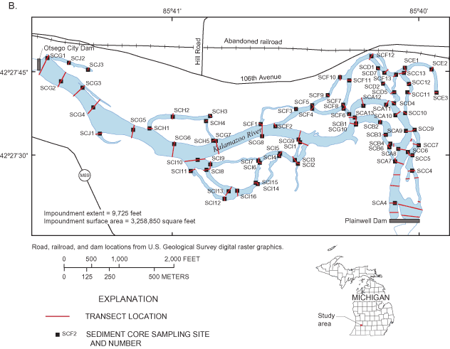
Figure 2b. Location of sediment core sample sites in the Otsego City impo...
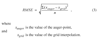
Figure 3. Area inundated (color shading) by the Otsego City Dam in (A) 1938...
Figure 3. Area inundated (color shading) by the Otsego City Dam in (C) 1988...
Figure 4. Bathymetry of the Otsego City impoundment on the Kalamazoo River,...
Figure 5. Depth to pre-dam alluvium in the Otsego City impoundment on the K...
Figure 6. Combined thickness of post-dam lacustrine deposits in the Otsego ...
Table 1. Summary of errors for grids used in sediment-volume estimate based...
Table 2. Bed-thickness and altitude measurements of core samples from the...
Table 3. Volume of sediment in the Otsego City impoundment at Otsego...
Appendix 1. Date, location, water velocity, altitude of surfaces,...
Appendix 2. Lithologic descriptions of sediment cores...
Appendix 3. Particle size of selected sediment samples...
| Multiply | By | To obtain |
|---|---|---|
| Length | ||
| inch (in.) | 25.4 | millimeter (mm) |
| foot (ft) | 0.3048 | meter (m) |
| mile (mi) | 1.609 | kilometer (km) |
| Area | ||
| square foot (ft2) | 0.09290 | square meter (m2) |
| square mile (mi2) | 2.590 | square kilometer (km2) |
| Volume | ||
| cubic yard (yd3) | 0.7646 | cubic meter (m3) |
| Flow rate | ||
| cubic foot per second (ft3/s) | 0.02832 | cubic meter per second (m3/s) |
| Mass/Weight | ||
| milligram (mg) kilogram (kg) | 0.00003527 2.205 | ounce, avoirdupois (oz) pound, avoirdupois (lb) |
Vertical coordinate information is referenced to the North American Vertical Datum of 1988 (NAVD 88). Horizontal coordinate information is referenced to the North American Datum of 1983 (NAD 83).
Abbreviated water-quality units used in this report: Chemical concentrations for bed sediment are given in milligrams per kilogram (mg/kg), a unit expressing the concentration of chemical constituents in bed sediment (dry weight) for synthetic organic compounds and trace elements. Numerical values expressed as milligrams per kilogram are the same as concentrations in parts per million (ppm).
ABBREVIATIONS
USEPA U.S. Environmental Protection Agency
PCBs Polychlorinated biphenyls
MDNR Michigan Department of Natural Resources
CDM Camp, Dresser & McKee
USGS U.S. Geological Survey
MDEQ Michigan Department of Environmental Quality
ERD Environmental Response Division
GPS Global Positioning System
SC Sediment Core
RP Reference Point
TL Transect Location
The removal of the Otsego City Dam on the Kalamazoo River at Otsego, Mich., is under consideration by the Michigan Department of Environmental Quality and the city of Otsego. The historical discharge of papermill waste containing polychlorinated biphenyls from sources upstream from the dam has led the U.S. Environmental Protection Agency to designate the Kalamazoo River from Morrow Dam near Comstock to its mouth near Saugatuck as a Federal Superfund site. The papermill waste is concentrated in organic sediment and kaolinite clay, with the sediment containing as much as 94 milligrams per kilogram polychlorinated biphenyls. This contaminated sediment could move if the dam is removed; therefore, it is necessary to estimate the characteristics and configuration of the sediment before removal plans begin.
Data from augered sections and sediment cores show that the current Otsego City impoundment sediments were deposited in two distinctly different sedimentary environments: (1) lacustrine sediments consisting of organic-rich silt and clay, fine to medium sand, and some gravel deposited in a repetitive, cyclic fashion related to former stream velocities when the Otsego City impoundment water levels were 2-4 feet higher (1880s-1960s), and from downstream movement of lacustrine sediments during the removal of the upstream Plainwell Dam superstructure in the 1980s; and (2) more recent (1980s-2002) coarse-grained alluvium deposited on top of the lacustrine sediments. The volume of instream sediment contained within the Otsego City impoundment is estimated to be about 457,270 cubic yards. This estimate is based on the composite thicknesses of the lacustrine deposits and overlying alluvium, which were determined to contain PCBs, and does not include bank or flood-plain deposits.
From the mid-1800s to the early 1900s, four dams were constructed on the Kalamazoo River between the cities of Plainwell and Allegan, Mich. (fig. 1). The Otsego City Dam was built in the 1840s in an effort to create a freight business on the Kalamazoo River (Dalrymple, 1972). The original dam was 5 ft high and contained a lock for the passage of barges, canoes, or rafts. In the 1880s, a papermill was built at the dam site and remains in operation to date (2002). Over the years, the dam has been rebuilt and repaired, providing a continuous industrial water supply for the mill.
Beginning in the 1950s, the storage capacities of the four impoundments were reduced by an influx of papermill waste rich in polychlorinated biphenyls (PCBs) from upstream industrial sources (Malcolm Pirnie Engineers, 1958). The primary industrial activity associated with PCB releases to the Kalamazoo River was the recycling of carbonless copy paper containing PCBs as an ink solvent (Camp Dresser & McKee, 1999). Kalamazoo-area papermills that de-inked or re-pulped paper from 1957 to 1971 incorporated the PCB-laden ink solvent in their waste discharge. These paper wastes also included kaolinite clays, which were found in the impoundment sediments to contain concentrations of PCBs as high as 94 mg per kg (Blasland, Bouck, & Lee, 1994). During the 1960s, water levels within three of the four impoundments were lowered, exposing previously inundated contaminated sediments. In response to the lowering of water levels, the river began to erode the sediments and transport them downstream, but much of this waste clay remains impounded behind the Otsego City Dam. If the dam is removed, transport and deposition of the impounded materials could alter the downstream characteristics of the stream channel and increase the PCB exposure potential to stream biota.
The presence of PCBs in the Kalamazoo River has prompted the U.S. Environmental Protection Agency (USEPA) to designate the reach from the city of Kalamazoo to its outlet into Lake Michigan as a Federal Superfund site. The Michigan Department of Environmental Quality-Environmental Response Division (MDEQ-ERD) and the city of Otsego are considering the removal of the Otsego City Dam (Dennis Eagle, MDEQ-ERD, oral commun., 2000). Removal of the structure will return this part of the Kalamazoo River to run-of-the-river flow and improve aquatic habitat in the reach. Removal of the dam can also result in problems such as movement of sediment downstream and migration of invasive species from the Great Lakes to headwater areas. Because additional impoundments downstream from the project area will remain in place, migration of invasive species should not be a problem; however, movement of contaminated sediments is a concern. The release of these sediments may result in the spread of additional contaminants into the downstream environment (Doyle and others, 2003).
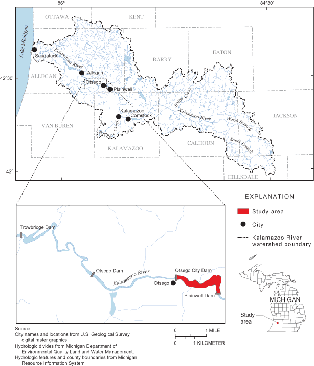
Figure 1. Location of Kalamazoo River watershed and study area in Michigan.
In the summers of 2001-2002, the U.S. Geological Survey (USGS), in cooperation with MDEQ-ERD and USEPA, conducted channel surveys of instream sediments in the Otsego City impoundment on the Kalamazoo River. Rheaume and others, 2002, reported on the volume, character, and size distribution of the instream sediments in the surrounding Plainwell, Otsego, and Trowbridge impoundments.
This report (1) describes the results of the USGS and MDEQ-ERD data-collection effort in the Otsego City impoundment, (2) relates this information to the depositional history of sediments behind the dam, and (3) provides an estimate of the volume of instream sediment in the Otsego City impoundment. Maps of sediment distribution and thickness, as well as tables of lithologic descriptions and particle-size analysis results, are provided.
The city of Otsego lies in the Kalamazoo River Valley in the southwestern part of Michigan (fig. 1). This river valley was a large, glacial meltwater channel, formed in the interlobate zone between the Michigan and Saginaw glacial-ice lobes during the late Pleistocene Epoch (Leverett and Taylor, 1915). As the Michigan Ice Lobe retreated to the west, broken upland ridges consisting of poorly bedded cobble, sand, and gravel, developed (Monaghan and Larson, 1984). These ridges mark the drainageways or channels of a much larger river than present that flowed during this glacial epoch (Deutsch and others, 1960). As ice blocks melted and outlets lowered, the Kalamazoo River was rejuvenated and developed its modern-day size and course (Martin, 1958).
Currently (2002), the main stem of the Kalamazoo River originates in Calhoun County at the confluence of the North and South Branches and flows northwestward for 123 mi to Lake Michigan near the city of Saugatuck. The river has meandering channels and point bars, and flows through a broad, well-defined flood plain. The Kalamazoo River has a drainage area of more than 2,000 mi2 with more than 400 mi of tributaries, including Portage Creek, a known source of PCBs (Stratus Consulting, Inc., 2000). A USGS streamflow-gaging station has been operating on the Kalamazoo River at Comstock, Mich., from 1931 to present (2002). The drainage area at Comstock is approximately 1,010 mi2. The mean annual flow for the 70-year period of record is 896 ft3/s. A maximum daily mean flow of 6,830 ft3/s was recorded on April 8, 1947, and a minimum daily mean flow of 185 ft3/s was recorded on August 7, 1934 (Blumer and others, 2001). The Kalamazoo River from Kalamazoo to Plainwell has an average slope of 2.6 ft/mi, whereas the average slope from Plainwell to Allegan is 4.9 ft/mi (Malcolm Pirnie Engineers, 1958). Historically, the river has been impounded for hydroelectrical and other industrial purposes where the gradients are higher (Blasland, Bouck & Lee, Inc., 1994).
This study was conducted to determine the volume, character, and size distribution of sediments in the Otsego City impoundment. The sediment volume estimate is for the instream reach from the Otsego City Dam to the foot of the Plainwell Dam (approximately 1.8 mi upstream) and does not include bank or flood-plain deposits.
Eighty-five transects were established in the impoundment (fig. 2a). Transect spacing on the main stem of the Kalamazoo River was based on the river width at the Otsego City dam (fig. 2a). Transect G1 was positioned as close to the dam as safety would allow. Transects G2, G3, and G4 were spaced upstream at intervals of one river width apart. Transects G5, G6, and G7 were spaced at intervals of two river widths apart. Transects G8, G9, and G10 were spaced at four river widths apart, providing data into the end of the backwater for the current (2002) impoundment. The distance from the dam to transect G10 is approximately 1.2 mi. The end of this backwater was indicated by increased river velocities, riffles, and debris islands. Transects in all other channels of the Otsego City impoundment (A, B, C, D, E, F, H, I, and J) generally were placed at the beginning, ending, or splitting of channels (fig. 2).
Reference points were established at each transect by driving a steel fence post into the right or left bank, close to the edge of the water. Altitudes of the top of the reference points were surveyed to 0.1 ft using Real Time Kinematic Global Positioning System (RTK GPS) equipment. Altitudes of bank height and water surface were measured from reference points as transects were completed.
A 3/16-in. steel cable tagline, painted at 5-ft intervals, was stretched across the river perpendicular to the channel at each transect. As the transect data were collected, latitude- longitude coordinates were taken at both ends of the tagline and at the left and right banks by use of a hand-held GPS unit. For locations along the main stem of the Kalamazoo River within the impoundment (G1-G10), the transect width between the banks was divided into 15 equal sections for measurements of water depth, water velocity, and sediment thickness (appendix 1). In all other river channels (A, B, C, D, E, F, H, I, and J), spacing of data points across transect lines generally was set at 10-ft intervals. The coordinates for individual data points were interpolated from the bank coordinates.
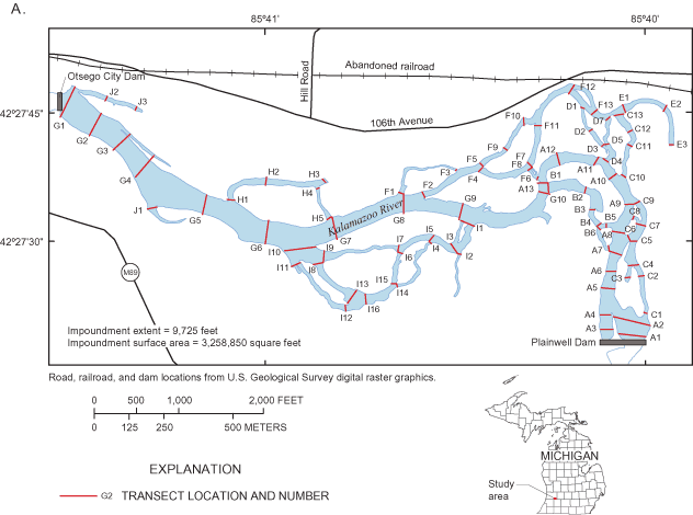
Figure 2a. Location of transects in the Otsego City impoundment on the Kalamazoo River, Mich.
Data points (water depth, water velocity, and sediment thickness) were collected across each transect in the impoundment. Water depths and water velocities were measured by standard USGS methods (Rantz and others, 1982) using a boat-cable measuring device equipped with an A-reel, a 15- or 30-lb weight, and a Price AA standard current meter.
Hand augering along transect lines was performed in order to determine sediment thickness. Thickness of the impoundment sediment was obtained by boring with a 1-ft-long by 11/2- in.-diameter auger bit with 4-ft extension pipes. The depth of the impoundment sediment that overlay the pre-dam alluvium (altitude prior to dam construction) was indicated when the auger could no longer be advanced. This contact between the pre-dam outwash and the post-dam sediments was distinct, and could be determined easily by a grinding that could be heard and felt when the auger bit contacted the underlying coarser material of cobbles and stones.
Core samples were collected at one point along selected transects, generally where impoundment sediments were thickest (fig. 2b). Cores were collected at depths where lithology changed by use of a stainless steel 2-in.-diameter sediment bore. Changes in sediment texture and color were observed in the field. A total of 164 samples from 76 core locations were collected and sieved at the Michigan State University Department of Geography Geomorphology Laboratory by use of U.S. Standard Sieves.
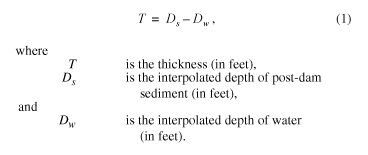
In order to estimate the volume of the instream sediments, a series of grids was generated by use of a geographic information system (GIS). Grid surfaces for water depth and post-dam sediment were interpolated on the basis of auger-point data by use of TOPOGRID in Arc/Info 8.2. Contours were generated from the interpolated grid surfaces. The contours were modified, redrawn manually on the basis of field observations, and used to create the final grid surfaces for water depth and post-dam sediment. The water-depth and post-dam-sediment grids were used to generate a thickness grid. The thickness of post-dam sediment was computed by means of the equation
The total estimated volume (Vtotal) of the instream impoundment sediment (in cubic yards) was computed by means of the equation

Areas between transects were digitized, and the number of square feet within each area was computed. These measured areas were used in conjunction with average sediment thickness per digitized area to compute volume of sediments between transects.
The accuracy of the grids was determined by comparing the computed value for each grid to the value at each auger-point. This comparison allowed for a root mean squared error (RMSE) by
The RMSE provides an error estimate for the grid cells corresponding to the auger-points, which were used as the control, and is a measurement of how well the interpolated surface fits the observed auger-point data. In the absence of additional data, these points are believed to be representative of the grid as a whole. As outlined in the "National Standard for Spatial Data Accuracy," the RMSE can be used to determine the accuracy using the equation for data with normally distributed error (Federal Geographic Data Committee, 1998).

A summary of the maximum residuals, RMSE, and accuracy are listed in table 1.
| Grid | Maximum residual | Root Mean Squared Error | Accuracy |
|---|---|---|---|
| Bathymetry | 2.4 | 0.82 | 1.61 |
| Sediment depth | 4.3 | .76 | 1.49 |
| Sediment thickness | 7.2 | 1.09 | 2.14 |
Stratigraphic relations among the sediments within and flanking the channel vary as a function of distance upstream from the dam. The area inundated by the impoundment during the different time periods is reflected by the sediment stratigraphy and can be divided into an upper zone and a lower zone.
The upper zone contains the reach flooded by the dam when it was fully operational at design-pool levels (2-4 ft higher than present). Backwater from the impoundment extended 1.6 mi upstream from the Otsego City Dam or 0.2 mi below the Plainwell Dam (fig. 2). As water levels behind the Otsego City Dam were lowered (late 1960s), previously inundated backwater sediment was exposed. In the upstream reach
of the historical impoundment, lacustrine deposits remain in the floodplain but have been eroded completely in the present-day river channel. At these locations, increased slopes and river velocities have exposed very coarse pre-dam alluvium, which in some places has been overlain by recent (1980s-2002) sand and gravel.
The lower zone is the 1.2-mi extent of backwater created by the present-day dam (approximately from the dam to transect G10; fig. 2). Three stratigraphic units can be identified in the lower zone. These units are (1) outwash and alluvial cobble, gravel, and sand deposited before dam construction, (2) interbedded lacustrine clay, silt, and sand deposited and redeposited when water levels were 2-4 ft higher in the impoundment, and (3) sand and gravel deposited after water levels in the impoundment were lowered.
Lithologic descriptions of the cores are given in appendix 2. Particle-size distributions for the samples are presented in appendix 3. A summary of the sediment thicknesses at core locations through the main stem of the river within the study reach is given in table 2.
As glacial ice retreated from the study area 10,000 to 15,000 years ago, meltwaters flowed westward through continually lowering outlets (Martin, 1958). The glacial Kalamazoo River was much larger than the present river, eroding large volumes of sediment as it cut through outwash and lake plains to form the Kalamazoo River Valley. After the end of the Pleistocene epoch, the volume of water discharged through the Kalamazoo River diminished greatly, leaving the river to occupy only a small part of its outwash and alluvium-filled ancestral river valley (Deutsch and others, 1960). For thousands of years, the Kalamazoo River meandered across the Kalamazoo River Valley, reworking the pre-dam outwash and alluvium. This pre-dam material is identified easily and consists of cobbles, coarse gravel, and lesser amounts of medium to coarse sand.
For approximately 80 years, the Otsego City Dam impounded water at levels 2-4 ft higher than present impoundment levels (fig. 3a). Lacustrine material deposited in the impoundment consisted of interbedded, organic-rich silt and clay, fine to medium sand, and some gravel deposited cyclically in response to changes in river velocities during high and low flows. Previous work has shown that elevated PCB concentrations are contained in the lacustrine deposits (Weston, Inc., 2002).
[Altitude in feet above NAVD88; ft, feet; transect locations shown in figure 2]
| Sediment core No. | Altitude of stream bottom (ft) | Altitude of base of post-dam sediment (ft) | Thickness of recent, post-drawdown alluvium (ft) | Thickness of the dam lacustrine sediments (ft) | Total thickness of impoundment sediment (ft) |
|---|---|---|---|---|---|
| Otsego City impoundment | |||||
| SC-G1 | 694.3 | 686.8 | 0.5 | 7.0 | 7.5 |
| SC-G2 | 692.3 | 684.8 | .5 | 7.0 | 7.5 |
| SC-G3 | 693.8 | 687.8 | 1.0 | 5.0 | 6.0 |
| SC-G4 | 692.8 | 687.8 | .5 | 4.5 | 5.0 |
| SC-G5 | 693.0 | 687.0 | 1.0 | 5.0 | 6.0 |
| SC-G6 | 694.7 | 691.2 | 1.0 | 2.5 | 3.5 |
| SC-G7 | 694.7 | 691.2 | 1.0 | 2.5 | 3.5 |
| SC-G8 | 696.7 | 688.7 | 2.5 | 5.5 | 8.0 |
| SC-G9 | 694.8 | 686.8 | 1.0 | 7.0 | 8.0 |
| SC-G10 | 697.1 | 689.6 | .0 | 7.5 | 7.5 |
| SC-A13 | 696.4 | 689.4 | 3.0 | 4.0 | 7.0 |
| SC-A12 | 696.5 | 690.1 | .0 | 6.4 | 6.4 |
| SC-A11 | 695.0 | 691.0 | 1.0 | 3.0 | 4.0 |
| SC-A10 | 697.4 | 695.4 | .0 | 2.0 | 2.0 |
| SC-A9 | 696.0 | 695.5 | .0 | .5 | .5 |
| SC-A8 | 696.8 | 696.2 | .6 | .0 | .6 |
| SC-A7 | 697.3 | 694.8 | .0 | 2.5 | 2.5 |
| SC-A6 | 694.6 | 694.6 | .0 | .0 | .0 |
| SC-A5 | 695.4 | 695.4 | .0 | .0 | .0 |
| SC-A2 | 698.0 | 698.0 | .0 | .0 | .0 |
| SC-A1 | 695.0 | 695.0 | .0 | .0 | .0 |
Judging from streambank elevations, the thickness of the lacustrine material was as much as 10.5 ft thick in the Otsego City impoundment by the mid-1960s. In the late 1960s, water levels were lowered in the Otsego City impoundment (fig. 3b), causing some of the previously deposited lacustrine sediments to be eroded and transported downstream. Demolition of the upstream Plainwell dam superstructure (Camp Dresser & McKee, 1999) in the mid-1980s resulted in appreciable channel erosion of lacustrine sediments in the Plainwell impoundment (Rheaume and others, 2002). The mobilized sediments subsequently were redeposited in channels of the Otsego City impoundment. This aggradation resulted in the river becoming more braided as the main channels were filled and new channels that were lower in elevation were cut (fig. 3c).
Auger-point data and sediment cores collected in 2001-02 showed that the thickness of the lacustrine deposits in the main stem of the present Kalamazoo River (fig. 3d) ranges from 0 to 7.5 ft in the Otsego City impoundment (table 2); however, thicknesses as great as 11.2 ft were observed in the side channels of the impoundment (appendix 1).
From an examination of sediment cores, the most likely period of channel stabilization was the 1980s. After the channels stabilized, sand and gravel began to aggrade within the impoundment from upstream sources. These recent coarse-grained alluvial deposits lie directly over the lacustrine deposits and, for the most part, consist of sands and gravel with lower PCB concentrations than those in the lacustrine sediments. Sediment samples of these deposits collected by the USEPA in 2001 contained PCB concentrations less than 30 ppm (Weston, Inc., 2002). These post-drawdown alluvium deposits are not PCB free because PCBs continued to be released into the channel from erosion of flood-plain deposits, slumping streambanks, and upstream channel-bed scour (Camp Dresser & McKee, 1999). Auger-point data and sediment cores collected in 2001-2002 showed that the thickness of the post-drawdown alluvium ranges from 0 to 3.0 ft in the main channel of the Otsego City impoundment (table 2).
Altitude of the water surface, present-day streambed, and base of the impoundment sediment was determined at each data point along transect lines. Altitudes for each layer were established by level and rod survey (appendix 1). Water depths in the impoundment during low flows ranged from 0 to 10 ft, with average depths being less than 7.5 ft (fig. 4).
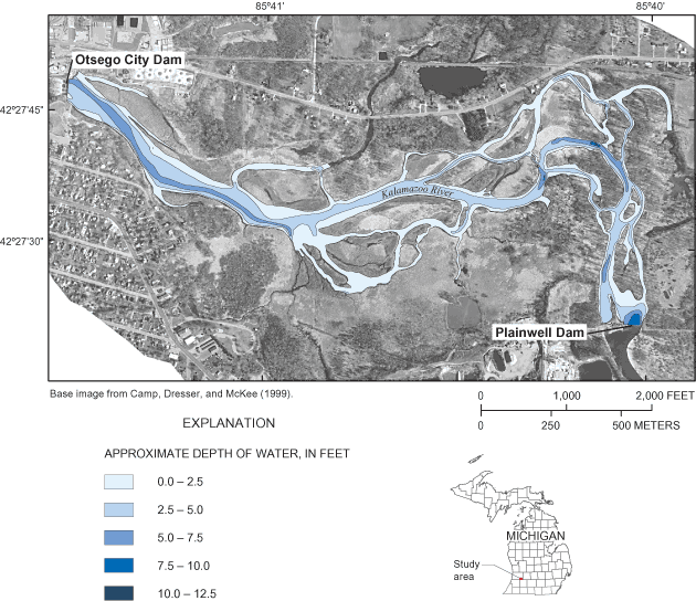
Figure 4. Bathymetry of the Otsego City impoundment on the Kalamazoo River, Mich.
As inferred from sediment-thickness data gathered near the dam, the streambed bottom of the pre-dam river was at altitudes 7-10 ft lower than the bottom of the present-day impoundment (fig. 5). Particle-size analysis of core samples collected in the impoundment indicate that the pre-dam river consisted of a cobble-gravel bottom and stable cobble-lined banks.
When water levels were lowered in the Otsego City impoundment during the mid-1960s, dam lacustrine sediments were eroded, transported, and redeposited. Subsequent demolition of the upstream Plainwell Dam in the mid-1980s resulted in the movement of lacustrine sediments in the Plainwell impoundment. As these sediments moved downstream, they filled in channels in the Otsego City impoundment. New channels were formed, and increased river velocities began to transport and deposit coarser grained sands and gravel from upstream.
Westjohn (1997) showed that both the coarse-grained alluvium and fine-grained lacustrine deposits in a river channel are capable of being transported downstream if a dam is removed. For this reason, the post-drawdown alluvium and dam lacustrine deposits are considered as one unit in the Otsego City impoundment and are reported together in the volume estimate as total cubic yards of instream sediment (fig. 6, table 3).
The estimated total volume of instream sediment in the Otsego City impoundment is 457,270 yd3. Sediment thickness ranges from 0 to 11.2 ft, and the average thickness is 3.7 ft over the 3,291,470-ft2 impoundment (appendix 1). Approximately 56 percent (258,000 yd3) of the total 457,270 yd3 of sediment in the impoundment is in the main-stem channel between the Otsego City Dam and Plainwell Dam (transects G1-G10, A13-A5, A2-A1); and 44 percent is in the side channels (B, C, D, E, F, H, J, & I). Of the 258,000 yd3 in the main channel, 93 percent is located in the lower half of the main channel between the dam and transect G10 (figs. 2A and 6).
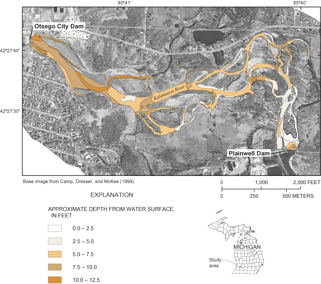
Figure 5. Depth to pre-dam alluvium in the Otsego City impoundment on the Kalamazoo River, Mich.

Table 3. Volume of sediment in the Otsego City impoundment at Otsego, Mich.
[ft, foot; ft2, square feet; yd3, cubic yards; transect locations shown in figure 2]
| Location of area | Surficial area (ft2) | Average thickness of sediment in digitized area (ft) | Volume of sediment in digitized area (yd3) |
|---|---|---|---|
| Otsego City Dam to transect G1 | 20,400 | 5.7 | 4,270 |
| Transect G1 to transect G2 | 132,710 | 5.5 | 26,790 |
| Transect G2 to transect G3 | 99,730 | 4.6 | 17,010 |
| Transect G3 to transect G4 | 96,350 | 4.6 | 16,390 |
| Transect G4 to transect G5 | 278,290 | 5.7 | 58,340 |
| Transect G5 to transect G6 | 207,020 | 4.2 | 32,040 |
| Transect G6 to transect G7 | 188,070 | 3.8 | 26,480 |
| Transect G7 to transect G8 | 168,690 | 4.1 | 25,680 |
| Transect G8 to transect G9 | 106,720 | 3.3 | 13,040 |
| Transect G9 to transect G10 | 182,350 | 2.7 | 18,250 |
| Transect G10 to transect A13 | 12,610 | 4.0 | 1,850 |
| Transect A13 to transect A12 | 37,960 | 2.8 | 3,950 |
| Transect A12 to transect A11 | 47,430 | 2.0 | 3,560 |
| Transect A11 to transect A10 | 25,960 | 1.2 | 1,200 |
| Transect A10 to transect A9 | 36,220 | .4 | 590 |
| Transect A9 to transect A8 | 43,250 | .3 | 530 |
| Transect A8 to transect A7 | 39,190 | .2 | 220 |
| Transect A7 to transect A6 | 24,980 | .3 | 310 |
| Transect A6 to transect A5 | 27,390 | .9 | 860 |
| Transect A5 to transect A2 | 97,690 | 1.0 | 3,590 |
| Transect A4 to Plainwell Dam | 41,050 | .8 | 1,260 |
| Transect A2 to transect A1 | 60,300 | .8 | 1,740 |
| Transect A1 to Plainwell Dam | 21,740 | 1.6 | 1,310 |
| Transect B1 to B7 | 118,570 | 4.0 | 17,690 |
| Transect C1 to C13 | 176,510 | 1.8 | 11,680 |
| Transect D1 to D7 | 50,610 | 4.1 | 7,740 |
| Transect E1 to E3 | 61,510 | 4.1 | 9,370 |
| Transect F1 to F13 | 301,180 | 4.3 | 47,650 |
| Transect H1 to H5 | 96,640 | 7.5 | 26,680 |
| Transect I1 to I10 | 435,650 | 3.9 | 62,990 |
| Transect J1 to J3 | 54,700 | 7.0 | 14,210 |
| Otsego City impoundment (total) | 3,291,470 | 457,270 |
The Michigan Department of Environmental Quality (MDEQ) and the city of Otsego, Mich. are considering the removal of the Otsego City Dam. Removal of the structure will return part of the Kalamazoo River to run-of-river flow and improve aquatic habitat in affected river sections. However, because of PCB contamination in the sediment, the U.S. Environmental Protection Agency (USEPA) has designated the Kalamazoo River from the city of Kalamazoo to its outlet into Lake Michigan as a Federal Superfund site. Removal of the dam may result in a mobilization of contaminated sediment with adverse consequences on the downstream environment.
The U.S. Geological Survey (USGS), in cooperation with MDEQ and USEPA, studied the volume, character, and size distribution of instream sediments in the Otsego City impoundment on the Kalamazoo River in 2001-2002. Water depth and sediment thicknesses were measured along 85 transects. Sediment cores were collected at 76 sites in the impoundment. Sediment-depth profiles and particle-size analysis of core samples formed the principal basis for an interpretation of the depositional history and lithology in the Otsego City impoundment. The following are major findings and conclusions of the study:
The authors thank Todd King (Camp Dresser & McKee, Inc., Detroit, Mich.) and Paul Bucholtz (Michigan Department of Environmental Quality-Environmental Response Division, Lansing, Mich.) for technical support. Many USGS employees participated in the collection and analyses of data for this study and preparation of this report. They include Suzanne Crowley, Don James, Rick Jodoin, Kevin Kennedy, Jason Killian, Brian Mailot, Marie Reynolds, Tiffiny Rossi, Julie Stopar, Mike Sweat, Atiq Syed and Cliff Winchester. Technical reviewers were Dan Button (U.S. Geological Survey, Columbus, Ohio) and Denis Healy (U.S. Geological Survey, Lansing, Mich.). Editorial and graphic support were provided by Michael Eberle and Leah Hout (U.S. Geological Survey, Columbus, Ohio), Sharon B. Baltusis (U.S. Geological Survey, Lansing, Mich.), and Debra Foster, Anita Cotton, and Ann Marie Squillacci (U.S. Geological Survey, Pembroke, N.H.)
Blasland, Bouck & Lee, Inc., 1994, Allied Paper, Inc./Portage Creek/Kalamazoo River Superfund site remedial investigation/feasibility study: Technical memorandum 10, Sediment Characterization/Geostatistical Pilot Study, v. I-III.
Blumer, S.P., Behrendt, T.E., Ellis, J.M., Minnerick, R.J., LeuVoy, R.L., and Whited, C.R., 2001, Water resources data, Michigan, water year 2000: U.S. Geological Survey Water-Data Report MI-00-1, 100 p.
Camp Dresser & McKee, 1999, Baseline ecological risk assessment-Allied Paper, Inc./Portage Creek/Kalamazoo River Superfund site: June 1999, Section 1-6.
Dalrymple, Dorothy, 1972, Bah Jove! Otsego is the Dandy Town, pamphlet [Otsego, Mich.].
Deutsch, Morris, Vanlier, K.E., and Giroux, P.R., 1960, Ground-water hydrology and glacial geology of the Kalamazoo area, Michigan: Michigan Geological Survey Progress Report 23, 122 p.
Doyle, M.W., Stanley, E.H., Harbor, J.M., and Grant, G.S., 2003, Dam removal in the United States: Emerging needs for science and policy, American Geophysical Union Eos, v. 84, no. 4, p. 29.
Federal Geographic Data Committee, 1998, Geospatial positioning accuracy standards Part 3: National Standard for Spatial Data Accuracy, National Spatial Data Infrastructure, FGDC-STD-007.3-1998, 25 p.
Leverett, Frank, and Taylor, F.B., 1915, The Pleistocene of Indiana and Michigan and the history of the Great Lakes: U.S. Geological Survey Monograph 53, 529 p.
Malcolm Pirnie Engineers, 1958, Report on low flow regulation of the Kalamazoo River: Battle Creek-Kalamazoo River Intermunicipality Study Committee: Malcolm Pirnie Engineers, Consulting Sanitary Engineers, New York 36, New York, December 1958, 40 p.
Martin, H.M., 1958, Outline of the geologic history of Kalamazoo County: Michigan Department of Conservation Geological Survey Division, 17 p.
Monaghan, G.W., and Larson, G.J., 1984, Glacial geology of Kalamazoo County, Michigan: East Lansing, Mich., Michigan State University, Department of Geology, 37 p.
Rantz, S.E., and others, 1982, Measurement and computation of streamflow: v. 1, measurement of stage and discharge: U.S. Geological Survey Water-Supply Paper 2175, 284 p.
Rheaume, S.J., Rachol, C.M., Hubbell, D.L., and Simard, Andreanne, 2002, Sedimentation characteristics for three dam impoundments on the Kalamazoo River, Michigan, 2000: U.S. Geological Survey Water-Resources Investigations Report 02-4098, 51 p.
Stratus Consulting, Inc., 2000, Pre-assessment screen, Kalamazoo River environment site, Michigan: Michigan Department of Environmental Quality, Michigan Attorney General, U.S. Fish and Wildlife Service, National Oceanic and Atmospheric Administration, May 30, 2000, chaps. 1-5.
Westjohn, D.B., 1997, Stratigraphy, sedimentology, and volume of sediments behind a dam relic on the Muskegon River, Big Rapids, Michigan: U.S. Geological Survey Water-Resources Investigations Report 97-4069, 14 p.
Weston, Inc., 2002, Removal assessment report for Allied Paper-Kalamazoo River site Otesgo/Plainwell, Michigan: U.S. Environmental Protection Agency, TDD No. 0103-002.
Appendix 1. Date, location, water velocity, altitude of surfaces,...
Appendix 2. Lithologic descriptions of sediment cores...
Appendix 3. Particle size of selected sediment samples...
For additional information about this report, contact:
Stephen Rheaume
E-mail: srheaume@usgs.gov
Phone: (517) 887-8905
Document Accessibility: Adobe Systems Incorporated has information about PDFs and the visually impaired. This information provides tools to help make PDF files accessible. These tools convert Adobe PDF documents into HTML or ASCII text, which then can be read by a number of common screen-reading programs that synthesize text as audible speech. In addition, an accessible version of Acrobat Reader 6.0, which contains support for screen readers, is available. These tools and the accessible reader may be obtained free from Adobe at Adobe Access.
| AccessibilityFOIAPrivacyPolicies and Notices | |
 |
|