USGS ORGANIZATIONAL STRUCTURE
The U.S. Geological Survey (USGS), a bureau within the U.S. Department of the Interior, manages four major Federal natural science activities: the National Mapping Program; Water Resources Investigations; Biological Research; and Geologic Hazards, Resources, and Processes programs.
National Mapping Division (NMD)
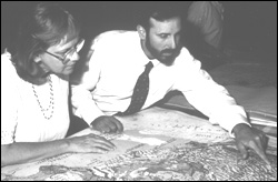
ESIC personnel explains map to customer.
|
The mission of the U.S. Geological Survey's National Mapping Division is to meet the Nation's need for basic geospatial data, ensuring access to and advancing the application of these data and other related earth science information for users worldwide. In support of this mission, we:
- Ensure the production and availability of basic cartographic and geographic spatial data of the country;
- Coordinate National geospatial data policy and standards;
- Provide leadership for the management of earth science data and for information management;
- Acquire, process, archive, manage, and disseminate the land remote sensing data of the Earth; and
- Improve the understanding and application of geospatial data and technology.
Water Resources Division (WRD)
|
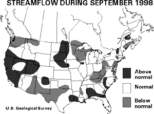
The U.S. Geological Survey has the principal responsibility within the Federal Government to provide the hydrologic information and understanding needed by others to achieve the best use and management of the Nation's water resources. To accomplish this mission, the Water Resources Division, in cooperation with State, local, and other Federal agencies, performs the following activities.
- Systematically collects and analyzes data to evaluate the quantity, quality, and use of the Nation's water resources and provides results of these investigations to the public.
- Conducts water resources appraisals describing the occurrence, availability, and physical, chemical, and biological characteristics of surface and ground water.
- Conducts basic and problem-oriented hydrologic and related research that aids in alleviating water resources problems and provides an understanding of hydrologic systems sufficient to predict their response to natural or human-caused stress.
- Coordinates the activities of Federal agencies in the acquisition of water resources data for streams, lakes, reservoirs, estuaries, and ground water.
- Provides scientific and technical assistance in hydrologic fields to other Federal, State, and local agencies; to licensees of the Federal Energy Regulatory Commission; and to international agencies on behalf of the Department of State.
- Administers the State Water Resources Research Institutes Program and the National Water Resources Research Grants Program.
Biological Resources Division (BRD)
The BRD mission is to work with others to provide the scientific understanding and technologies needed to support the sound management and conservation of our Nation's biological resources. A fundamental part of our mission is embodied in our deep commitment to make data and information on the Nation's biological resources more accessible to more people.
The majority of BRD programs and resources remain directed towards the needs and responsibilities of Department of the Interior resource management bureaus, such as studies supporting development of annual waterfowl regulations, research leading to better land protection strategies for National parks, and investigations seeking optimal water control practices for enhancement of fisheries.
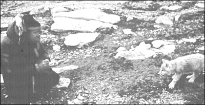
David Mech, BRD scientist, led a wolf study team in Denali National Park.
|
But an equally important BRD objective has been the establishment and ongoing development of a National Biological Information Infrastructure (NBII), a network of distributed databases and information sources on biological resources. Today, NBII information is being used by Federal and State agencies, researchers, universities and museums, planning and environmental consultants, private companies, landowners, and the
public.
In support of that objective, the BRD is engaged in a cooperative effort to define biological data standards and protocols needed to facilitate the use and sharing of biological data. This effort is building on existing standards and protocols, where possible, as well as on parallel National efforts for a National Information Infrastructure and a National Spatial Data Infrastructure.
Geologic Division (GD)
The Geologic Division (GD) administers the Earthquake Hazards, Volcano Hazards, National Cooperative Geologic Mapping, Coastal and Marine Geology, Global Change and Climate History, Mineral Resources, Energy Resources, and Integrated Natural Resource Science programs. The GD also has program responsibilities for the Global Seismographic Network, landslide hazards, and international activities. GD can be described by seven science goals designed to address pressing issues facing the Nation in the next decade. In general, these goals focus on understanding human interaction with the natural environment and build upon long-term USGS investments in basic research into the fundamental geologic processes controlling how the Earth works. These goals are as follows.
- Conduct geologic hazard assessments for mitigation planning.
- Provide short-term prediction of geologic disasters and rapidly characterize their effects.
- Advance the understanding of the Nation's energy and mineral resources in a global geologic, economic, and environmental context.
- Anticipate the environmental impacts of climate variability. This goal defines a leadership role for the USGS within the U.S. National Global Change.
- Establish the geologic framework for ecosystem structure and function.
- Interpret the links between human health and geologic processes.
- Determine the geologic controls on ground-water resources and hazardous waste isolation.
The Geologic Division's ability to respond to each of these societally driven goals requires a sustained investment in documenting the present and past state of the Earth and in using this information to predict future changes.
The USGS is the Nation's largest water, earth, and biological science, and civilian mapping agency. The USGS works in cooperation with more than 2,000 organizations across the country to provide reliable, impartial scientific information to resource managers, planners, and other customers. This information is gathered in every State by USGS scientists to minimize the loss of life and property from natural disasters, contribute to the sound conservation and the economic and physical development of the Nation's natural resources, and enhance the quality of life by monitoring water, biological, energy, and mineral resources.
The USGS has identified four principal theme areas -- Hazards, Natural Resources, Environment, and Information Management -- to more effectively communicate how USGS earth science information contributes to public policy issues.
PREVIOUS || TABLE OF CONTENTS || NEXT
This page is https://pubs.usgs.gov/98financial/structure.html
Maintained by Eastern Publications Group Web Team
Last updated July 6, 1999