 U.S. Geological Survey
 Spatial Data in Geographic Information
System Format on Agricultural Chemical Use, Land Use, and
Cropping Practices in the United States
Spatial Data in Geographic Information
System Format on Agricultural Chemical Use, Land Use, and
Cropping Practices in the United States
By William A. Battaglin and Donald A. Goolsby
This is an electronic version of U.S. Geological Survey Water-Resources Investigations
Report 94-4176. To view the figures, you will need an external viewer for ".gif" images.
To see the tables, you will need a PostScript viewer.
The original report contains examples of data documentation, and instructions for
ordering the data. This version includes direct links for on-line viewing of the
actual documentation and for on-line retrieval of the data sets.
Table of Contents
ABSTRACT
INTRODUCTION
SCOPE
METHODS USED TO PROCESS SOURCE DATA INTO GEOGRAPHIC INFORMATION SYSTEM PRODUCTS
DATA SOURCES FOR GEOGRAPHIC INFORMATION SYSTEM COVERAGES
OBTAINING AND USING THE GEOGRAPHIC INFORMATION SYSTEM COVERAGES
SUMMARY
SELECTED REFERENCES
APPENDIX 1. On-line Retrieval of Documentation and Data Sets
FIGURES
Figure 1. Estimated annual county-level herbicide use, 1989: (a) atrazine; (b) alachlor.
Figure 2. Estimated annual county-level herbicide use, 1989: (a) metolachlor; (b) EPTC.
Figure 3. Estimated annual county-level herbicide use, 1989: (a) 2,4-D; (b) cyanazine.
Figure 4. Estimated annual county-level herbicide use, 1989: (a) metribuzin; (b) simazine.
Figure 5. Estimated annual county-level (a) nitrogen-fertilizer use and (b) phosphate use,
July 1, 1986, to June 30, 1987.
Figure 6. Estimated annual county-level (a) nitrogen-fertilizer use and (b) potash use,
July 1, 1990, to June 30, 1991.
Figure 7. Estimated annual county-level farm expenses for (a) commercial fertilizer and (b)
agricultural chemicals, 1987.
Figure 8. Estimated (a) harvested cropland, 1987, and (b) harvested, irrigated cropland, 1987,
expressed as a percentage of the total area of each county.
Figure 9. Estimated area treated with (a) commercial fertilizer, 1987, and (b) products
used to control weeds, grass, or brush in crops and pasture, 1987, expressed as a percentage of
the total area of each county.
Figure 10. Estimated number of (a) cattle and calves, 1987, and (b) broilers and
other meat-type chickens, 1987, by county.
Figure 11. Estimated harvested (a) corn for grain or seed, 1987, and (b) soybeans for
beans, 1987, expressed as a percentage of the total area of each county.
Figure 12. Estimated harvested (a) sorghum for grain or seed, 1987, and (b) wheat
for grain, 1987, expressed as a percentage of the total area of each county.
TABLES
The spatial data in geographic information system format described in this report consist of
estimates for all counties in the conterminous United States of the annual use of 96 herbicides
in 1989; annual sales of nitrogen fertilizer, in tons, for 1985-91; and agricultural expenses,
land use, chemical use, livestock holdings, and cropping practices in 1987. The source information,
originally in tabular form, is summarized as digital polygon attribute data in the 18 geographic
information system spatial data layers (coverages) provided. The information in these coverages can
be used in estimating regional agricultural-chemical use or agricultural practices and in producing
visual displays and mapping relative rates of agricultural-chemical use or agricultural practices
across broad regions of the United States.
Agricultural chemicals (herbicides,
insecticides, and fertilizers) are used extensively in the
United States to increase yields of agricultural crops.
Many agricultural chemicals are partially water
soluble and can leach to ground water or run off to
surface water (Thurman and others, 1992). The
presence of agricultural chemicals in ground water and
surface water has been documented in many recent
reports (Madison and Brunett, 1985; Goolsby and
others, 1991a; Goolsby and others, 1991b; Goolsby
and Battaglin, 1993; Spalding and Exner, 1991;
Thurman and others, 1991; Thurman and others, 1992;
U.S. Environmental Protection Agency, 1992;
Battaglin and others, 1993; Scribner and others,
1993; Kolpin and others, 1993; and Burkart and
Kolpin, 1993). Analysis of relations among the
presence and distribution of agricultural chemicals in
the environment, estimates of agricultural-chemical
use, estimates of agricultural land use, and
descriptions of hydrologic conditions is greatly
facilitated by the application of geographic-
information-system (GIS) technology (Battaglin and
others, 1994; Battaglin and others, 1993; Goolsby and
Battaglin, 1993; Kolpin and others, 1993; Rains and
Latham, 1993; and He and others, 1993).
This report describes the data sources and
methods used to construct spatial data layers in GIS
format (coverages) on agricultural-chemical use and
agricultural practices that may help in future research
concerning the presence and distribution of
agricultural chemicals in water resources of the United
States. The coverages contain information at the
county scale for the conterminous United States. The
3,111 counties of the conterminous United States
constitute the study area for this report.
The report contains: (1) 18 ARC/INFO (GIS software produced and distributed by Environmental Systems
Research Institute) GIS coverages summarizing the annual use of 96 herbicides in 1989; annual sales of
nitrogen fertilizer, in tons, for 1985-91; and agricultural expenses, land use, chemical use, livestock
holdings, and cropping practices in 1987, for counties in the conterminous United States; (2) complete
on-line documentation of the 18 coverages and a self-installing version the U.S. Geological Survey's
documentation AML (ARC Macro Language) (Nebert, 1994); and (3) 12 page-sized color maps summarizing
selected attribute data from the 18 coverages (see figs. 1-12). These products were prepared by the
U.S. Geological Survey in cooperation with the U.S. Environmental Protection Agency under Interagency
Agreement DW14934820-01-1.
Information from four primary sources is summarized as polygon attribute data in the 18 coverages provided.
Five coverages summarizing the use of 96 herbicides were constructed from estimates reported in Gianessi
and Puffer (1991). Seven coverages summarizing annual nitrogen fertilizer sales, in tons, for the years
1985-91 were constructed from estimates reported by the U. S. Environmental Protection Agency (1990)
and by Jerald Fletcher (West Virginia University, written commun., 1992). Six coverages summarizing
agricultural expenses, land use, chemical use, livestock holdings, and cropping practices were
constructed from estimates reported by the U. S. Department of Commerce (1989a, 1989b) in the 1987
Census of Agriculture. The 18 coverages contain a total of 521 attributes that were derived from the
four cited data sources. All coverages described in this report were created and documented, and are
stored on-line, in accordance with the guidelines given by Nebert (1994).
A polygon coverage representing county
boundaries in the conterminous United States, as well
as lakes, estuaries, and other nonland-area features, is
used as the base for the coverages described in this
report. The base county coverage was derived from the
Digital Line Graph (DLG) files representing the
1:2,000,000-scale map in the National Atlas of the
United States (U.S. Geological Survey, 1970;
Domeratz and others, 1983). Polygon coverages in
general are used to represent area features. Polygons
are defined by a series of arcs that form a many-sided,
closed figure. A label point inside each polygon is
used to assign attributes to the polygon. Attributes can
contain any information that pertains to the area
represented by the polygon. For example, every
polygon in the base coverage contains an attribute
called PLYTYPE which is a numeric code that
indicates whether the polygon represents land, a lake,
or an estuary. Each county land polygon is identified
by a five-digit Federal Information Processing
Standard (FIPS) code. Some counties are represented
by more than one polygon.
A missing value code of -99.0 is used when no attribute data are given for a county land polygon
and also is used for all nonland-area polygons. Attribute values in counties represented by one
polygon are equal to county totals. For counties described by more than one polygon, attribute
values are provided for each polygon and are calculated as the county total multiplied by the
ratio of the area of each county polygon to the total area of the county. For example, if county
A is represented by two polygons of equal area, and 1,000 pounds of atrazine are reported to have
been used in county A, then the value of the attribute for pounds of atrazine used for each of
the two polygons representing county A would be 500 pounds.
Automated procedures were developed for
processing the raw herbicide-use, nitrogen-fertilizer-
sales, and 1987 Census of Agriculture data into ARC/
INFO coverage attributes. Procedures generally were
coded in AML (Environmental Systems Research
Institute, 1992); however, some Fortran codes and
awk programs (Aho and others, 1988) also were used.
The procedure was to copy the ARC/INFO county
base coverage to a new coverage and then execute an
attribute addition AML program to transfer attribute
values from the raw data files to the new coverage.
Other automated procedures were developed to
calculate summary statistics of attribute values, and to
produce maps (color postscript files) that represent
attribute values across the United States (figs. 1-12).
The on-line documentation file that accompanies each
coverage was generated by using the program
document.aml, which is available from the U.S.
Geological Survey (Nebert, 1994). On-line data
documentation may be seen by following the
instructions in
appendix 1.
All products were inspected visually for obvious errors. County-level herbicide-use estimates
were sometimes absent as a result of withheld census data. County herbicide-use data cannot be
totaled to obtain the State use totals reported in Gianessi and Puffer (1991) because of differences
between statewide crop-acreage estimates (which include all counties) and county-level crop-acreage
estimates (some of which are withheld because of census disclosure rules). Estimates of
nitrogen-fertilizer use in Utah in 1985 are missing. Estimates from the 1987 Census of Agriculture
were compared visually with maps published in U. S. Department of Commerce (1990). Most missing
data in unexpected areas results from withholding of Census of Agriculture data as a result of census
disclosure rules. Additional details concerning the processing of coverage and ancillary information
are given in the Data Sources For Geographic Information System Coverages section of this report.
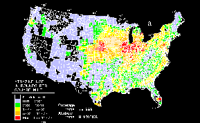
Color maps summarizing 24 selected attributes
from the 18 coverages were constructed in ARC/INFO
by use of a consistent methodology (see figs. 1-12).
The maps were developed to show locations and
relative rates of agricultural-chemical use or
agricultural practices across broad regions of the
United States. A statistical distribution was used to
select six class intervals for the graphic display of
agricultural-chemical use, land use, and cropping-
practice data. The empty (white) class (see figs. 1-12)
represents counties in which attribute values are
missing or zero. The first shaded class (light blue)
represents attribute values that are reported (not
missing or zero) and as large as the 25th percentile of
the data. The second shaded class (green) represents
attribute values that are greater than the 25th
percentile and as large as the 50th percentile (median)
of the data. The third shaded class (yellow) represents
attribute values that are greater than the median and as
large as the 75th percentile of the data. The fourth
shaded class (orange) represents attribute values that
are greater than the 75th percentile and as large as the
75th percentile plus two standard deviations of the
data. The fifth shaded class (red) represents attribute
values that are greater than the 75th percentile plus
two standard deviations.
Five coverages summarizing the use of 96 herbicides were constructed from estimates reported in
Gianessi and Puffer (1991). A ranking of national herbicide-use amounts (Gianessi and Puffer, 1991,
Table A-6) was used to divide herbicide-use attribute data into five coverages. The tabular
estimates of herbicide use by county and by crop were constructed by Gianessi and Puffer (1991) by:
- (1) compiling statistics, by State and by crop, on the percentage of acres treated with a given
herbicide and the average annual application rate of the herbicide from responses to surveys sent to
U.S. Department of Agricultural Cooperative Extension Service weed scientists in 1987 and 1989;
- (2) augmenting survey data with published surveys and reports from individual States (U.S.
Department of Agriculture, 1989a; U.S. Department of Agriculture, 1989b; Rinehold and Witt, 1989)
- (3) establishing herbicide-use profiles, by State and by crop, that contain the percentage of
acres treated and average annual application rates;
- (4) multiplying county-level crop-acreage estimates from the 1987 Census of Agriculture (U.S.
Department of Commerce, 1989a) by the percentage of acres treated and the average annual application rates to obtain herbicide-use estimates; and
- (5) tabulating herbicide-use amounts and acres treated by crop and by county.
Eighty-four crops were profiled, resulting in usage estimates for 96 herbicide active ingredients.
Although crop acreages are from 1987 data, the herbicide-use estimates generally reflect 1989 usage
amounts (Gianessi and Puffer, 1991). Estimates of herbicide use by county were generated from a
combination of data collected from surveys of weed scientists and from surveys of farmers.
Herbicide-use profile data were generated by using ancillary data sources or were calculated
from profiles for neighboring States when no responses to surveys or published reports were
available (Gianessi and Puffer, 1991). Sampling and statistics were used to account for crop
acreages from nonresponding farm operations. Thus, the information describing crop acreages
is subject to sampling variability as well as reporting and coverage errors (U.S. Department
of Commerce, 1989b). Census disclosure rules also prevent the publication of information that
would reveal the operation of individual farms.
Herbicide-use attributes by crop and by county were extracted from the tabular data files provided
by Gianessi and Puffer (1991). The total use of each herbicide on all crops was calculated for
all counties with herbicide use. Three attributes were added to an ARC/INFO coverage for each of
the 96 herbicides. Attributes with names ending in .ACR are estimates of the number of acres
treated with a given herbicide. Attributes with names ending in .LBS are estimates of the total
number of pounds of active ingredient of a given herbicide applied on all crops. Attributes
ending in .USE are estimates of a county-level herbicide-use rate in pounds per square mile.
Attribute names are keyed to four-digit herbicide code numbers provided in
table 1. For
example, estimates of the number of pounds of atrazine applied are contained in the attribute
named H1980.LBS. Herbicide-coverage names, attribute names, and the crops on which the largest
amount of active ingredient of each herbicide was used are listed in
table 2.
Herbicide-use estimates for counties represented by one polygon are equal to county totals.
For counties described by more than one polygon, herbicide-use estimates are provided for each
polygon and are calculated as the county total multiplied by the ratio of the area of the county
polygon divided by the total area of the county. A missing-value code of -99.0 is used when no
herbicide-use estimates are available for a county and for all nonland-area polygons. A
missing-value code in a county land polygon can indicate any of the following conditions:
- -- herbicide not used in the county (for example, no alachlor used in county),
- -- crop data withheld because of census disclosure rules,
- -- crop data not available to the census, or
- -- crop data not published because county contains fewer than 10 farms.
Seven coverages summarizing annual nitrogen-fertilizer sales, in tons, for the fertilizer years
1985-91 (for example, the 1987 fertilizer year is the period from July 1, 1986, to June 30, 1987),
were constructed from estimates reported by the U.S Environmental Protection Agency (1990).
Estimates for 1990 and 1991 were provided to the U.S. Geological Survey by Jerald Fletcher
(West Virginia University, written commun., 1992) in cooperation with the National Fertilizer and Environmental Research Center, Tennessee Valley Authority (TVA). Estimates of fertilizer sales estimates were generated and are reported as tons of actual nutrient (inorganic nitrogen, phosphate, and potash). The fertilizer-sales estimates do not account for the use of manure.
The method used to construct fertilizer sales estimates is similar to that used by
Alexander
and Smith (1990). The data are summarized for fertilizer years . The county-level
nitrogen-fertilizer sales estimates (U.S. Environmental Protection Agency, 1990) were
constructed by:
- (1) compiling annual State fertilizer-sales data reported as tonnages to the National Fertilizer
and Environmental Research Center of the TVA;
- (2) calculating the ratio of expenditures for commercial fertilizers by county to
expenditures for commercial fertilizers by State from the 1987 Census of Agriculture
(U.S. Department of Commerce, 1989a); and
- (3) computing annual county-level fertilizer sales, in tons, by multiplying estimates
of annual State sales by the ratio of county expenditures to State expenditures.
Nitrogen-fertilizer sales estimates by county were constructed from estimates reported by the
U.S. Environmental Protection Agency (1990) for 1985-89 and by Jerald Fletcher (West Virginia
University, written commun., 1992) for 1990-91. The estimates of nitrogen-fertilizer sales in
tons of actual nutrient were entered directly into the GIS. Nitrogen-fertilizer sales estimates
are provided for each year (1985-91); however, the 1987 Census of Agriculture data on fertilizer
expenditures used to disaggregate State sales totals represent only 1987 sales. Fertilizer-sales
data submitted annually to State regulatory agencies by fertilizer dealers were compiled by the
National Fertilizer and Environmental Research Center, TVA (U.S. Environmental Protection Agency,
1990). These data reflect total sales of fertilizer without regard to the land use for which
it was bought, or the State (or county) in which the fertilizer was actually used.
Estimates of fertilizer sales by county were constructed from a combination of data reported
to State regulatory agencies and from data in the 1987 Census of Agriculture. In the Census
of Agriculture, sampling and statistics are used to account for nonresponding farm operations
(U.S. Department of Commerce, 1989b). Thus, the information that describes county-level fertilizer
sales is subject to sampling variability as well as reporting and coverage errors. Census
disclosure rules also prevent the publication of information that would reveal the operation
of individual farms.
Eleven attributes were added to an ARC/INFO coverage for each year of fertilizer-sales data.
All attribute names contain a number that represents the year of the data. For example, NTOT86
is the attribute name for total nitrogen-fertilizer sales in 1986. Sales estimates are provided
for total nitrogen, potash, and phosphate, and for nitrogen sold as ammonium nitrate, anhydrous
ammonia, miscellaneous forms, nitrogen solutions, and urea. Nitrogen-fertilizer sales coverage
names, attribute names, and short attribute descriptions are listed in
table 3.
Fertilizer-use estimates for counties represented by one polygon are equal to county totals.
For counties described by more than one polygon, fertilizer-use estimates are provided for
each polygon and are calculated as the county total multiplied by the ratio of the area of
the county polygon divided by the total area of the county. A missing-value code of -99.0 is
used when no fertilizer-use estimate is available for a county and in all nonland-area polygons.
A missing-value code in a county land polygon can indicate any of the following conditions:
- -- fertilizer not sold in the county,
- -- crop data withheld because of census disclosure rules,
- -- crop data not available to the census, or
- -- crop data not published because county contains fewer than 10 farms.
Six coverages summarizing agricultural expenses, land use, chemical use, livestock holdings, and
cropping practices were constructed from estimates reported by the U. S. Department of Commerce
(1989a, 1989b) in the 1987 Census of Agriculture. A total of 123 data fields from the Census of
Agriculture are summarized by 156 attributes in the 6 coverages. Most of the attributes summarized
represent 1987 data, but some information from the 1982 Census of Agriculture also was included.
The estimates were constructed from surveys of all farms where $1,000 or more of agricultural
products were sold, or normally would have been sold, during the census year. Sampling and
statistics were used to account for nonresponding farm operations. Thus, the information in
the Census of Agriculture is subject to sampling variability as well as reporting and coverage
errors. Census disclosure rules prevent publication of information that would disclose the
operation of individual farms. Thus, for example, one or two sod farms may be reported in a
county, but no acreage of sod grown is reported, because release of that information might
disclose information about a particular farmer's operation.
All census attributes were extracted from tabular
data files provided by the U. S. Department of
Commerce (1989a). Data are reported in either
thousands of dollars, number, tons, acres, or percent of
county. Attribute names are keyed to field names
found in the technical documentation of the Census of
Agriculture (U.S. Department of Commerce, 1989b).
Specifically, the four-digit number at the end of the
ARC/INFO item names matches the field-name
numbers in the technical-documentation reference.
Complete definitions of attributes and terms used in
the census can be found in U. S. Department of
Commerce (1989b; 1990). Census of Agriculture
coverages and attribute names and short descriptions
are listed in
table 4. Attribute names beginning with
CA represent data fields transferred directly from the
census tabular data files. Attribute names beginning
with PCT are percent-of-county attributes and
represent relative intensities of an agricultural
practice. Attributes reported as percent of county were
calculated as the attribute value (in acres) divided by
the county polygon area (in acres) multiplied by 100.
Census estimates for counties represented by one polygon are equal to county totals.
For counties described by more than one polygon, attribute values are provided for each
polygon and are calculated as the county total multiplied by the ratio of the area of each
county polygon divided by the total area of the county. A missing-value code of -99 is used
when no census-attribute data are given for a county and for all nonland-area polygons.
A missing-value code in a county land polygon could indicate any of the following conditions:
- -- agricultural practice not present in county (for example, no corn grown in county),
- -- data withheld because of census disclosure rules,
- -- data not available to census, or
- -- data not published because county contains fewer than 10 farms.
The GIS coverages described in this report were prepared in compliance with the guidelines presented
by Nebert (1994) for National-scope thematic data layers. These coverages are available through the
U.S. Geological Survey Distributed Spatial Data Library (DSDL) (Nebert, 1994). DSDL is a distributed
repository, and custody of specific data sets is assigned to individuals or groups within the
organization. Complete documentation (metadata) and review of spatial and attribute information
are required for all data sets prior to their inclusion in DSDL. Information in DSDL is accessible
to the wide-area network and can be retrieved by using information-discovery programs such as the
Wide Area Information Server (WAIS), gopher, or mosaic. The GIS coverages described in this report
currently (1994) also can be made available on 1/4-inch tape or in DLG-O format upon special request
to the Regional Hydrologist.
The coverages are retrievable as individual themes. The compressed ARC/INFO coverage export files range
in size from 4.1 to 4.9 megabytes (MB). Uncompressed, these files range in size from 8.5 to 10.9 MB.
All 18 uncompressed ARC/INFO coverage export files occupy about 170 MB of disk space. All 18 imported
ARC/INFO coverages occupy about 100 MB of disk space. Generally, about 200 to 300 MB of disk space
is required to work with data sets of this size. Instructions for on-line data retrieval are given in
appendix 1.
The information on agricultural-chemical use, land
use, and cropping practices presented in this report are
intended for use directly in a geographic information
system. Several aspects of the processing of this
information into GIS coverage format are important
when working with the data. First, census disclosure
rules affect the content of all of the coverages. In some
cases the absence of a reported value for a particular
attribute in a particular county is the result of census
disclosure rules rather than a true zero value for the
attribute in that county. Second, for counties described
by more than one polygon, attribute values are
provided for each polygon and are calculated as the
county total multiplied by the ratio of the area of each
county polygon to the total area of the county. This
operation makes the coverage easier to work with in
the GIS but also means that care must be used when
the information in the coverages is used to estimate
total attribute values for counties described by more
than one polygon. Most of the counties in the
coverages are represented by only one polygon,
however. Third, additional details on coverage
preparation, item definitions, and coverage projection
are given in the on-line coverage documentation files
(see example in appendix 1). Not all of the
documentation files were printed in this report because
of their length (about 35 pages each). The GIS
coverage attributes that are accessible to users are
listed in tables 1-4.
The information summarized in the coverages provided is intended for use in estimating regional
agricultural-chemical use, land use, or cropping practices, and in producing visual displays and
mapping relative rates of agricultural-chemical use, land use, or cropping practices across broad
regions of the United States (Battaglin and Goolsby, 1994; Battaglin and others, 1993; Goolsby and
others, 1993; Goolsby and Battaglin, 1993; Mueller and others, 1993). The estimates provided can
not be used appropriately to determine rates of agricultural-chemical use or the presence or
absence of a particular agricultural practice in small areas (less than 20 square miles) or at
specific locations.
Eighteen geographic information system spatial data layers (coverages) summarizing for all
counties in the conterminous United States the use of 96 herbicides in 1989; the annual sales
of nitrogen fertilizer, for 1985-91; and agricultural expenses, land use, chemical use, livestock
holdings, and cropping practices in 1987 are discussed in this report and are available through
the U.S. Geological Survey Distributed Spatial Data Library (DSDL). Information in DSDL is
accessible to the wide-area network. The information in these coverages is intended for use
in estimating regional agricultural-chemical use, land use, or cropping practices, and in producing
visual displays and mapping relative rates of agricultural-chemical use, land use, or cropping
practices across broad regions of the United States.
The 18 coverages were constructed by relating tabular source materials to a polygon coverage
representing county boundaries, lakes, estuaries, and other nonland-area features in the
conterminous United States at a scale of 1:2,000,000.
- Aho, Alfred V., Kernighan, Brian W., and Weinberger, Peter J., 1988, The AWK programming
- language: New York, Addison-Wesley Publishing Company, 210 p.
- Alexander, Richard B., and Smith, Richard A., 1990, County-level estimates of nitrogen and
- phosphorus fertilizer use in the United States, 1945 to 1985: U.S. Geological Survey Open-File
Report 90-130, 12 p.
- Battaglin, W.A., Goolsby, D.A., and Mueller, D.K., 1994, Relations between use, concentration,
- and transport of agricultural chemicals in the Mississippi River basin, in Marston, R.A.,
and Hasfurther, V.R., eds., Effects of human-induced changes on hydgrologic systems, proceedings of the
American Water Resources Association Summer Symposium, Jackson Hole, Wyoming, June 26-29, 1994, p. 1073-1086.
- Battaglin, W.A., Goolsby, D.A., and Coupe, R.H., 1993, Annual use and transport of agricultural
- chemicals in the Mississippi River, 1991-92, in Goolsby, D.A., and others, eds., Selected
papers on agricultural chemicals in water resources of the Midcontinental United States: U.S. Geological
Survey Open-File Report 93-418, p. 26-40.
- Battaglin, W.A., and Goolsby, D.A., 1994, Relations between herbicide use and annual transport of
- herbicides in Midwestern rivers, 1991-92, in Weigmann, D. L., ed., New directions in pesticide
research, development, management, and policy, Proceedings of the Fourth National Conference on Pesticides,
November 1-3, 1993, p. 711-723.
- Burkart, M.R., and Kolpin, D.W., 1993, Hydrologic and land-use factors associated with
- herbicides and nitrate in near-surface aquifers: Journal of Environmental Quality, v. 22, no. 4, p. 646-656.
- Domeratz, M.A., Hallam, C.A., Schmidt, W.E., and Calkins, H.W., 1983, USGS digital cartographic
- data standards--Digital line graphics from 1:2,000,000-scale maps: U.S. Geological Survey Circular 895-D,
38 p.
- Environmental Systems Research Institute, 1992, AML user's guide: Redlands, Calif.,
- Environmental Systems Research Institute, Inc., various pagination.
- Gianessi, Leonard P., and Puffer, Cynthia, 1991, Herbicide use in the United States:
- Washington, D.C., Resources for the Future, December 1990 (revised April 1991), 128 p.
- Goolsby, D.A., and Battaglin, W.A., 1993, Occurrence, distribution and transport of agricultural
- chemicals in surface waters of the midwestern United States, in Goolsby, D.A., and others,
eds., Selected papers on agricultural chemicals in water resources of the Midcontinental United States:
U.S. Geological Survey Open-File Report 93-418, p. 1-25.
- Goolsby, D.A., Battaglin, W.A., and Thurman, E.M., 1993, Occurrence and transport of
- agricultural chemicals in the Mississippi River Basin, July through August 1993: U.S. Geological Survey
Circular 1120-C, 22 p.
- Goolsby, D. A., Coupe, R.H., and Markovchick, D. J., 1991b, Distribution of selected herbicides and
- nitrate in the Mississippi River and its major tributaries, April through June 1991: U.S. Geological
Survey Water-Resources Investigations Report 91-4163, 35 p.
- Goolsby, D.A., Thurman, E.M., and Kolpin, D.W., 1991a, Herbicides in streams--Midwestern
- United States, in Irrigation and drainage, Proceedings of the 1991 American Society of Civil
Engineers Conference, Honolulu, Hawaii, July 22-26, 1991, p. 17-23.
- He, Chansheng, Riggs, James F., and Kang, Yung-Tsung, 1993, Integration of geographic
- information systems and a computer model to evaluate impacts of agricultural runoff on water quality,
in Harlin, J.M., and Lanfear, K.J., eds., Proceedings of the Symposium on Geographic Information
Systems and Water Resources: American Water Resources Association Technical Publication Series TPS-93-1,
Mobile, Ala., March 14-17, 1993, p. 61-70.
- Kolpin, D.W., Goolsby, D.A., Aga, D.S., Iverson, J.L., and Thurman, E.M., 1993, Pesticides in
- near-surface aquifers--Results of the Midcontinental United States ground-water reconnaissance, 1991-92,
in Goolsby, D.A., and others, eds., Selected papers on agricultural chemicals in water
resources of the Midcontinental United States: U.S. Geological Survey Open-File Report 93-418, p. 64-74.
- Madison, R.J., and Brunett, J.O., 1985, Overview of the occurrence of nitrate in ground water of
- the United States, in National Water Summary 1984--Hydrologic events, selected water-quality
trends, and ground-water resources: U.S. Geological Survey Water-Supply Paper 2275, p. 93-105.
- Mueller, D.K., Ruddy, B.C., and Battaglin, W.A., 1993, Relation of nitrate concentrations in
- surface water to land use in the upper-midwestern United States, 1989-90, in Goolsby, D.A., and
others, eds., Selected papers on agricultural chemicals in water resources of the Midcontinental United
States: U.S. Geological Survey Open-File Report 93-418, p. 41-50.
- Nebert, Douglas D., 1994, Design of the distributed spatial data library for the Water Resources
- Division, U.S. Geological Survey: U.S. Geological Survey Open-File Report 94-327, 30 p.
- Rains, L., and Latham, P., 1993, GIS modelling of land use and associated nonpoint source
- pollution, in Harlin, J.M., and Lanfear, K.J., eds., Proceedings of the Symposium on
Geographic Information Systems and Water Resources: American Water Resources Association Technical Publication
Series TPS-93-1, Mobile, Ala., March 14-17, 1993, p. 35-44.
- Rinehold, J.W., and Witt, J.M., 1989, Oregon pesticide use estimates for 1987: Corvallis Oregon
- State University Extension Service, various pagination.
- Scribner, E.A., Thurman, E.M., Goolsby, D.A., Meyer, M.T., Mills, M.S., and Pomes, M.L., 1993,
- Reconnaissance data for selected herbicides, two atrazine metabolites, and nitrate in surface water of the
midwestern United States, 1989-90: U.S. Geological Survey Open-File Report 93-457, 77 p.
- Spalding, R.F., and Exner, M.E., 1991, Nitrate contamination in the contiguous United States, in
- Bogardi, I., and Kuzelka, R.D., eds., Nitrate contamination--Exposure, consequence, and control:
Berlin, Springer-Verlag, North Atlantic Treaty Organization Advanced Science Institutes Series, v.
G 30, p. 13-48.
- Thurman, E.M., Goolsby, D.A., Meyer, M.T., and Kolpin, D.W., 1991, Herbicides in surface water
- of the midwestern United States--The effect of the spring flush: Journal of Environmental Science and
Technology, v. 25, no. 10, p. 1794-96.
- Thurman, E.M., Goolsby, D.A., Meyer, M.T., Mills, M.S., Pomes, M.L., and Kolpin, D.W., 1992, A
- reconnaissance study of herbicides and their metabolites in surface water of the midwestern United States
using immunoassay and gas chromatography/mass spectrometry: Journal of Environmental Science and
Technology, v. 26, no. 12, p. 2440-2447.
- U.S. Department of Agriculture, 1989a, Agricultural resources--Situation and outlook report:
- U.S. Department of Agriculture, Economic Research Service, February, Washington, D.C.
- U.S. Department of Agriculture, 1989b, Agricultural resources--Situation and outlook report:
- U.S. Department of Agriculture, Economic Research Service, August, Washington, D.C.
- U.S. Department of Commerce, 1989a, Census of agriculture, 1987--Final county file: U.S.
- Department of Commerce, Bureau of the Census [machine-readable data file].
- ________ 1989b, Census of agriculture, 1987-- Final county file technical documentation:
- U.S. Department of Commerce, Bureau of the Census, Data User Services Division, various pagination.
- ________ 1990, Census of agriculture, 1987-- Agricultural atlas of the United States,
- volume 2: U.S. Department of Commerce, Bureau of the Census, Agriculture Division, AC87-S-1, 210 p.
- U.S. Environmental Protection Agency, 1990, County-level fertilizer sales data: U.S.
- Environmental Protection Agency, Office of Policy, Planning, and Evaluation, PM-221.
- ________ 1992, Another look--National pesticide survey phase II report,
- Washington, D.C., 174 p.
- U.S. Geological Survey, 1970, National atlas of the United States of America:
- Washington, D.C., U.S. Geological Survey, 417 p.
Choose any file to see the documentation, or "metadata." The metadata contains
instructions for on-line retrieval.
Storage Requirements
The 18 files represent about 80 megabytes (MB) of raw binary data.
The compressed ARC/INFO coverage export files range in size from 4.1 to 4.9 MB.
Uncompressed, these files range in size from 8.5 to 10.9 MB. The 18 uncompressed
ARC/INFO coverage export files will occupy about 170 MB of disk space. The 18
imported ARC/INFO coverages will occupy about 100 MB of disk space. In general,
about 200 to 300 MB of disk space will be required to work with data sets of this magnitude.
Recommended Directory Structure
All of the coverages can be stored under one directory, or separate directories can be made for
the Census of Agriculture, herbicide-use, nitrogen-fertilizer sales, and other National extent
and scale coverages. To prevent corruption or unwanted modification of the coverages provided,
create a large work space for manipulation and processing involving the coverages. Copy coverages
to the work space before executing any ARC, ARCEDIT, ARCPLOT, or GRID commands that may affect
coverage topology or attributes. Failure to make working copies of the coverages could result in
the corruption of the original data or in the loss of the metadata describing coverage construction
and attributes.
[an error occurred while processing this directive]