Stratigraphy, Rock Types, and Volcanic History
Geochronology by Lawrence W. Snee
Figure 1. Map of the Little Wood River area, south-central Idaho, showing geographic l...
Figure 2. Geologic map of part of the Little Wood River area, south-central Idaho ..
Figure 3. Generalized stratigraphic sections of the Challis Volcanic Group ...
Figure 4. Detailed stratigraphic sections of the Challis Volcanic Group in ...
Figure 5. Chemical variation diagram showing volcanic rocks from Little Woo...
Table 1. Whole rock analyses of volcanic rocks, Little Wood River area, sou...
U.S. Department of the Interior
Gale A. Norton, Secretary
U.S. Geological Survey
Charles G. Groat, Director
U.S. Geological Survey, Reston, Virginia: 2005
Posted online May 2005, version 1.0
This publication is only available online at: https://pubs.usgs.gov/bul/2064/ii/
For more information about the USGS and its products:
Telephone: 1-888-ASK-USGS
World Wide Web: http://www.usgs.gov/
Any use of trade, product, or firm names in this publication is for descriptive purposes only and does not imply endorsement by the U.S. Government.
Although this report is in the public domain, it contains copyrighted materials that are noted in the text. Permission to reproduce those items must be secured from the individual copyright owners.
Sanford, R.F., 2005, Geology and stratigraphy of the Challis Volcanic Group and related rocks, Little Wood River area, south-central Idaho, with a section on Geochronology by Lawrence W. Snee: U.S. Geological Survey Bulletin 2064-II, 22 p.
The southwestern part of the Challis volcanic field occupies the valley of the Little Wood River and its tributaries in the Hailey and Idaho Falls 1°×2° quadrangles of south-central Idaho. The Little Wood River area is a structurally controlled topographic basin that is partly filled by Eocene Challis Volcanic Group and younger rocks. Rock types in the Challis Volcanic Group of the Little Wood River area include, in order of decreasing abundance, andesite lava flows and tuff breccia, dacite lava flows and flow breccia, volcaniclastic sedimentary rocks, lithic tuff, nonvolcanic conglomerate, and rhyolite dikes.
A basal nonvolcanic conglomerate, that locally rests on upper Paleozoic sedimentary rocks at a regional unconformity, was deposited prior to eruption of volcanic rocks. Andesite was the first volcanic rock erupted and is a voluminous sequence as thick as 3,000 ft (1,000 m). Locally thick volcaniclastic sedimentary rocks accumulated in topographic lows. A sharp transition marks the beginning of dacite eruption from fissures and flow-dome complexes. Dacite flows and breccias are as thick as 2,000 ft (600 m). An upper volcaniclastic unit was deposited in paleotopographic lows following emplacement of the main dacite unit. Next, a widespread, distinctive, lithic rich ash flow tuff, correlated with the tuff of Stoddard Gulch, was deposited over much of the area. Deposition of the tuff was followed by eruption of thin andesite and dacite lava flows and deposition of conglomeratic sedimentary rocks. The entire sequence was then intruded by a dacite flow-dome complex composed of at least three separate intrusions.
The Challis Volcanic Group in the study area is calc alkaline. Andesitic rocks are typically high potassium basaltic andesite, high potassium andesite, shoshonite, and banakite (latite). Dacitic rocks are high potassium dacite and trachyte. Tuffs and vitrophyres range in composition from basaltic andesite to trachyte. The paleotopographic basin in which the Challis Volcanic Group accumulated was in part structurally controlled by preexisting west and northwest trending normal faults. Paleorelief was probably more than 2,000 ft (600 m). Rocks of the Challis Volcanic Group typically dip about 36° E., probably owing to Eocene extension and (or) basin-and-range faulting and tilting. Some potential for precious and base metal hydrothermal deposits is associated with northeast trending lineaments, argillic alteration, and rhyolite dikes.
The Challis volcanic field in central Idaho is the largest of several Eocene volcanic fields in the Pacific Northwest of the United States and Canada. Other fields include the British Columbia alkalic province, the Sanpoil field in northeastern Washington and southern British Columbia (Carlson and others, 1991), the Clarno field in north-central Oregon (Suayah and Rodgers, 1991), the Absaroka field in Montana and Wyoming (Gest and McBirney, 1979), the Montana alkalic province (O’Brien and others, 1991), and small scattered outliers (Moye and others, 1988). The Challis volcanic field was erupted during the Kamloops Challis Absaroka volcanic episode at 51–40 Ma (Armstrong and Ward, 1991).
Two models have been proposed to explain Eocene volcanism in the region. In one model, subduction of a very shallow dipping Farallon plate beneath the continent created a wide volcanic arc (Lipman and others, 1971, 1972; Lipman, 1980). In the other model, volcanic activity resulted from rifting as a result of collision between the Pacific and North American plates (Ewing, 1980; Fox, 1983; Fox and Beck, 1985). The later model was developed for Eocene rocks of northeastern Washington and British Columbia. A number of studies present data aimed at a comprehensive description of Eocene volcanism (Gest and McBirney, 1979; McIntyre and others, 1982; Moye, 1984; Meen, 1987; Hackett and others, 1988; Moye and others, 1988; Norman, 1988; Armstrong and Ward, 1991; Carlson and others, 1991; Dudas, 1991; Lipman and Glazner, 1991; Norman and Mertzman, 1991). In this study, I present stratigraphic, compositional, and structural data on a previously poorly known part of the Challis volcanic field that will aid in understanding the origin and evolution of Eocene volcanism in the Pacific Northwest. In view of the relative lack of attention given to intermediate composition volcanism (Lipman and Glazner, 1991), the Little Wood River area, and its several thousands of feet of intermediate-composition volcanic rocks, is a rich source of information.
(Click on thumbnail to view image)
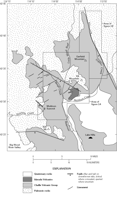
The stratigraphy of the Challis Volcanic Group has been described for the northern part of the Challis volcanic field in the Challis 1°×2° quadrangle (Leonard and Marvin, 1982; McIntyre and others, 1982; Ekren, 1985) and for the southeastern part of the field in the Idaho Falls 1°×2° quadrangle (Moye and others, 1988; McDermott and Snider, 1989; Snider and Moye, 1989). In this report, I present data for the southwestern part of the Challis volcanic field in the Little Wood River area in the Hailey and Idaho Falls 1°×2° quadrangles (fig. 1). Most of this area was previously unmapped except for reconnaissance mapping at a scale of 1:100,000. Umpleby and others (1930) and Dover (1981) mapped the extreme northern part of the area. Nelson and Ross (1969) and Lukowitz (1971) mapped much of the Mackay 3NW and Mackay 3SW 7½-minute quadrangles east of long 113° W. Hall and Batchelder (1979) mapped the Baugh Creek Southwest 7½-minute quadrangle. Sanford (1988) and Sanford and others (1989) mapped the Little Wood River Wilderness Study Area, which includes parts of the Baugh Creek and Mackay 3NW 7½-minute quadrangles. W.E. Hall and J.N. Batchelder (unpublished field notes, 1973–1975, U.S. Geological Survey library) conducted reconnaissance mapping of parts of the Seamans Creek, Little Wood River, and Baugh Creek 7½-minute quadrangles. Schmidt (1961) mapped some of the southern part of the area. The geology of the Little Wood River area is shown on compilations by Rember and Bennett (1979a, b) and Worl and others (1991).
Mapping for this report was done during the summers of 1987–88. Reconnaissance mapping was carried out in the Little Wood River area, and detailed mapping was performed at a scale of 1:24,000 in the Baugh Creek 7½-minute quadrangle and adjacent areas, including parts of the Mackay 3NW, Mackay 3SW, Little Wood River, and Seamans Creek 7½-minute quadrangles. Results of detailed mapping are shown in figure 2.
(Click on thumbnail to view image)
A: Baugh Creek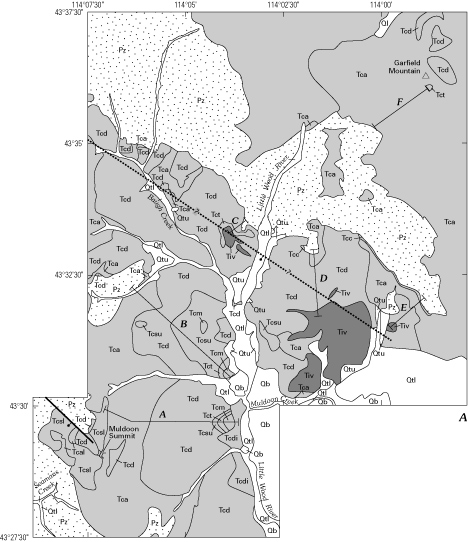 B: Copper Creek
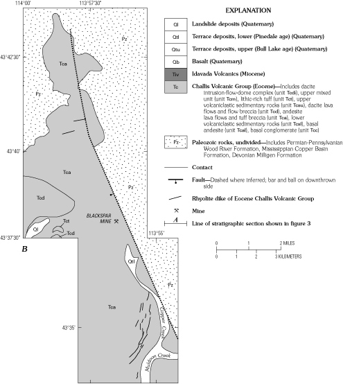
The Little Wood River area is a structurally controlled topographic basin that is partly filled by the Eocene Challis Volcanic Group and younger rocks. Elevated areas around the basin consist mostly of resistant siliceous sedimentary rocks of the Middle Pennsylvanian to Lower Permian Wood River Formation and lesser amounts of Lower to Upper Devonian Milligen Formation and Lower to Upper Mississippian Copper Basin Formation. Depositional relationships of the Challis Volcanic Group are complex, because of the large topographic relief on the pre Challis surface and the multitude of volcanic centers and rock types. Rocks of the Challis Volcanic Group typically dip about 36° E. Units overlying the Challis Volcanic Group include the almost flat lying Miocene Idavada Volcanics and Quaternary basalts, gravels, and other unconsolidated sediments.
The Devonian Milligen Formation (Umpleby and others, 1930; Sandberg and others, 1975) consists of black, thinly bedded (1–4 in., 2.5–10 cm) chert and phyllitic, fissile quartzite, and thick (15–20 ft, 4.5–6 m) light-gray, sandy limestone. These rock types are interbedded with subordinate, brown-weathering, finely laminated, dark-gray dolomite and slightly calcareous, gray-, brown-, and maroon-weathering siltstone and black argillite.
The Mississippian Copper Basin Formation (Umpleby and others, 1930; Paull and others, 1972; Nilsen, 1977; Paull and Gruber, 1977) consists of dark-gray turbidites including boulder to granule conglomerate, sandstone, siltstone, mudstone, and limestone in its lower part and gray, poorly sorted, fine to very coarse grained, medium- to thick bedded lithic sandstone and dark-gray to grayish-black mudstone or argillite in its upper part.
The Middle and Upper Pennsylvanian and Lower Permian Wood River Formation (Umpleby and others, 1930; Bostwick, 1955; Hall and others, 1974; Mahoney and others, 1991) consists of gray calcareous sandstone, brown weathering sandy limestone, gray siltite, gray quartzite, bluish gray limestone, and dark gray chert. The base of the Wood River is characterized by quartz pebble conglomerate. Limestone weathers dark brown. Crossbedding, convolute structures, and load casts are common in the calcareous sandstone. Locally, where overlain by thick sequences of Challis andesite, the Wood River Formation is contact metamorphosed. The hornfels is jet black, vitreous, and unusually hard; northwest of Muldoon Summit, the hornfels is 33 ft (10 m) thick.
In the Little Wood River area the Challis Volcanic Group includes, in order of decreasing abundance, andesite lava flows and tuff breccia, dacite lava flows and flow breccia, volcaniclastic sedimentary rocks, lithic tuff, nonvolcanic conglomerate, and rhyolite dikes. These rock types comprise 10 map units: from oldest to youngest, basal conglomerate, basal andesite, lower volcaniclastic sedimentary rocks, andesite lava flows and tuff breccia, dacite lava flows and flow breccia, upper volcaniclastic sedimentary rocks, lithic rich tuff, upper mixed unit, dacite intrusion–flow-dome complex, and rhyolite dikes (figs. 2–4, app.). In the northeastern part of the study area, east of the Little Wood River, the section consists of conspicuously stratified andesite flows and tuff breccia. In the northeastern part of the study area, west of the Little Wood River, the section consists of dacite flows and flow breccias that have almost no apparent stratification. In the central part of the study area, large areas are dominated by unstratified dacite flows and flow breccias, particularly in the Baugh Creek area. Between Muldoon Summit and the Little Wood River, the section consists of stratified flows and breccia comprising approximately equal volumes of andesite and dacite. Because this area includes the most complete and representative section, a detailed section was measured (fig. 4, app.).
The basal conglomerate rests unconformably on the Wood River Formation and crops out in a narrow band south of Elk Mountain (fig. 2A). The conglomerate probably correlates with the informal basal Smiley Creek conglomerate of Paull (1974), which has been described from many places elsewhere in the Challis volcanic field (Nelson and Ross, 1968, 1969; Dover, 1969, 1983; Paull, 1974; McIntyre and others, 1982; Fisher and others, 1983; Burton and Blakey, 1988). In the Little Wood River area, the conglomerate is steeply dipping and exhibits an angular unconformity with the underlying Wood River Formation. Thickness varies from 0 to 150 ft (0–50 m). The conglomerate is massive and has little internal sedimentary structure. It is light gray and consists of gray quartzite pebbles 1–10 cm in diameter in a white fine-grained matrix. Unlike other locations in the Challis volcanic field, no volcanic clasts were observed in the Little Wood River area. The closest suitable source for the conglomerate is a paleohigh north of the outcrop where resistant beds of the Wood River Formation today form a topographic high in the area of Elk Mountain; however, more distant sources are possible. Lack of volcanic detritus in the conglomerate in the Little Wood River area indicates that volcanic activity had not yet begun, at least not in the source area for the conglomerate. Dips of bedding of as much as 60° indicate postdepositional tilting.
An early phase of intermediate composition volcanism is recognized throughout the Challis volcanic field as the first of three main phases of volcanism (McIntyre and others, 1982; Moye and others, 1988). In the Little Wood River area, this phase is represented by large volumes of andesite and later dacite lava flows, ash flow tuff, and tuff breccia (fig. 4, app.).
Andesite is a part of three units that are locally distinguishable: a basal andesite, a main andesite, and an upper mixed unit (fig. 4, app.). The basal andesite is separated from the main andesite by a volcaniclastic layer. The main andesite is separated from the upper mixed unit by an upper volcaniclastic unit and a tuff unit. In most of the study area, where the intervening volcaniclastic and tuff units are absent, the andesite is mapped as a single, undivided andesite unit (fig. 2). A thick andesite unit at the base of the Challis Volcanic Group is typical of the entire volcanic field (Leonard and Marvin, 1982; McIntyre and others, 1982; Ekren, 1985; Moye and others, 1988; McDermott and Snider, 1989; Snider and Moye, 1989).
The basal andesite crops out near the head of Seamans Creek west of Muldoon Summit (fig. 2A). It consists of lava flows deposited unconformably on the Wood River Formation. Thickness varies from 0 to 500 ft (0–170 m). It weathers brown and is black, dark gray, and greenish brown on fresh surfaces. Pyroxene and hornblende phenocrysts as long as 0.25 mm are common to abundant, and plagioclase phenocrysts, as long as 1 mm, are rare to common. Pits on weathered surfaces of the andesite may indicate dissolved olivine.
The lower volcaniclastic sedimentary unit crops out in the vicinity of Muldoon Summit (fig. 2A). Both lower and upper volcaniclastic units are generally poorly exposed, form gentle slopes, and are associated with landslides. The lower sedimentary unit is best exposed along road cuts. It consists of very immature, epiclastic, volcaniclastic sedimentary rocks that are buff, white, and green, massively bedded to finely laminated, poorly consolidated sandstone, siltstone, pebble conglomerate, and claystone. Graded bedding is common. Clasts are angular to subrounded and include detrital plagioclase, sanidine, biotite, and hornblende grains, volcanic clasts, chert clasts, and carbonized wood and leaf fragments. The fine horizontal laminations, graded bedding, pebbles, and well-preserved plant remains indicate deposition in moderate- to low-energy streams and lakes. Plagioclase and mafic minerals in sandstone locally impart a salt-and-pepper texture. Rock fragments have a maximum diameter of 2 cm. Clasts are typically matrix supported. The detrital grains consist of minerals characteristic of phenocrysts in rocks of the Challis Volcanic Group and indicate erosion and reworking of volcanic rocks.
(Click on thumbnail to view image)
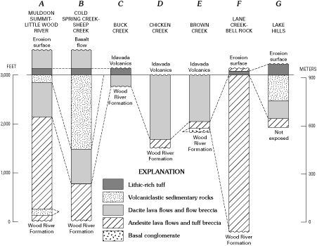
The main andesite makes up about 60–80 percent of the preserved Challis Volcanic Group in the Little Wood River area and is more than 3,000 ft (1,000 m) thick in the vicinity of Garfield Mountain (figs. 3, 4). Although vents were not recognized, the thickest accumulation of andesite probably indicates the primary source area. The andesite typically forms well-stratified deposits consisting of lava flows and tuff breccia. Volcaniclastic sedimentary rocks identical to the lower and upper sedimentary units are commonly interbedded with andesite flows and breccia, indicating that volcanic material was transported as lava flows, ash flow tuff, and stream sediment. Stream transported volcaniclastic detritus and plant matter were reworked and deposited in stream channels and small lakes. Andesite lava flows are massive and fractured and tend to form resistant cliffs and knobs, whereas andesite tuff breccia tends to form gentle slopes having a distinctive dark-greenish-brown color. Flows are locally vesicular, especially at flow tops. Some vesicles are filled with calcite, quartz, chalcedony, epidote(?), or, in at least one case, amethyst. Both andesite flows and tuff breccia are greenish brown, gray, and buff gray on fresh surfaces and weather reddish brown and brownish gray. Locally, a red weathering rind as thick as 1 mm is present. Tuff breccia is monolithic to heterolithic and contains subangular fragments of porphyritic and nonporphyritic andesite, dacite, and vitric tuff. Andesite flows and fragments of flows contained in tuff breccia are porphyritic, glomeroporphyritic, and aphanitic and contain phenocrysts of plagioclase, pyroxene, hornblende, biotite, olivine(?), and opaque iron oxide minerals in a finely crystalline groundmass. Phenocrysts range in size from 0.5 to 5 mm and in abundance from 0 to 60 percent.
A sharp transition marks the change from andesite to dacite eruption (figs. 3, 4). Locally, volcaniclastic sedimentary rocks indicate an erosional unconformity at this transition. The main dacite unit erupted from fissures and formed flow dome complexes mainly west of the Little Wood River. These complexes are as thick as 2,000 ft (600 m). Dacite flows and flow breccias filled paleotopographic lows and blanketed the older andesite. The viscous flows built up coalescing domes that created a complex topographic surface. Dacite lava flows and flow breccia are distinguishable locally but grade into one another over relatively short distances (feet). Dacite flows and breccia commonly form steep slopes, cliffs, and knobs. They typically are massive, and crude columnar jointing is present locally. Blocks of andesite and dacite in the breccia are as much as 12 ft (4 m) in diameter. Weathered and unweathered surfaces are purplish, reddish, and greenish gray. Textures are porphyritic to glomeroporphyritic, and phenocrysts include plagioclase, biotite, hornblende, and pyroxene. Plagioclase crystals are commonly 3–5 mm in size and constitute 10–40 percent of the rock. Biotite commonly forms conspicuous books, locally altered to a bronzy color, that are 2–3 mm in size and commonly aligned parallel with foliation. Groundmass is white, light gray, and dark gray and aphanitic.
An upper volcaniclastic sedimentary unit was deposited in paleotopographic depressions following emplacement of the main dacite unit. The upper sedimentary unit crops out mainly between Cold Spring Creek and Hailey Creek and in the Lake Hills. The best exposures are in gullies and landslide scarps and range from 0 to 160 ft thick (0 to 48 m). As in the lower sedimentary unit, clastic material consists of reworked volcanic rock and coalified plant debris. The unit consists of very immature, epiclastic, volcaniclastic sedimentary rocks that are buff, white, gray, green, and pink, massively bedded to finely laminated, poorly consolidated sandstone, siltstone, pebble conglomerate, boulder conglomerate, and claystone. Graded bedding is common, and crossbedding, cut and fill structures, and synsedimentary slump features are locally present. Horizontal laminations, graded bedding, planar crossbedding, channel scours, transported boulders, carbonized wood fragments, and well preserved leaf impressions indicate transport and deposition in low- to high-energy lakes and streams. Clasts are angular to subrounded and consist of detrital plagioclase, sanidine, biotite, and hornblende grains, volcanic clasts, glassy lithic fragments, and carbonized wood and leaf fragments. Plagioclase and mafic minerals in sandstone locally impart a salt-and-pepper texture. Rock fragments have a maximum diameter of 3 ft (1 m). Clasts are typically matrix supported. The suite of detrital grains indicates erosion and reworking of volcanic rocks.
(Click on thumbnail to view image)

Next, a thin, distinctive, lithic-rich composite, welded to unwelded ash flow tuff was deposited, probably over much of the study area (fig. 4). Because of erosion, only small remnants of the tuff remain. West of the Little Wood River, the tuff consists of three emplacement units, the bottom two of which formed one cooling unit (app.). The lithic-rich tuff forms a distinctive marker horizon that typically forms low rubbly ledges and cuestas where it crops out in three places west of the Little Wood River, in several places on Garfield Mountain, and in the Lake Hills. It is lithologically very similar to and probably correlates with the tuff of Stoddard Gulch in the southeastern part of the Challis volcanic field, which has been dated at 44.3±2.7 Ma using K-Ar methods on hornblende (Skipp, 1988, 1989) and at 47.3±0.15 Ma using Ar-Ar methods on biotite (F.J. Moye, unpub. data, 1989). The tuff in the Little Wood River area represents the interval of explosive volcanism that characterizes the middle phase of Challis volcanism throughout the volcanic field as identified by Moye and others (1988). In the Little Wood River area, the tuff is thickest in the Lake Hills and thinner both west and north, ranging from 0 to more than 100 ft (30 m) in thickness. Lithic-rich tuff is reddish brown where devitrified and black and perlitic where still vitrified; it commonly has a white or green altered matrix. The lithic-rich tuff is unwelded to densely welded and vitric-, crystal-, and pumice-rich. Lithic material constitutes 10–20 percent of the rock and phenocrysts 10–25 percent. Phenocrysts include plagioclase averaging 2 mm in diameter and conspicuous euhedral books of biotite averaging 2 mm in diameter. Biotite is aligned parallel with foliation. Lithic material ranges from 2 mm to 25 cm in size and includes andesite, dacite, and rhyolite clasts. Pumice fragments are 5–15 cm long and moderately to extremely flattened.
Above the ash-flow tuff is a sequence of mixed thin andesite flows separated by volcaniclastic conglomerate that forms the upper mixed unit (fig. 4, app.). Clasts of rhyolite indicate that some rhyolite was emplaced prior to deposition of the upper mixed unit. Rare clasts of Paleozoic quartzite indicate that some Paleozoic rocks were being eroded, but the predominance of volcanic clasts indicates that the Challis Volcanic Group covered most of the area.
A period of dacite intrusion and flow-dome formation followed deposition of the andesite and conglomerate of the upper mixed unit. Late dacite flow-dome emplacement corresponds to the third and final phase of Challis volcanism as identified by Moye and others (1988). Crosscutting relations are clearly visible for a distance of 2 mi (3.2 km) from the top of the measured section near the junction of the Little Wood River and Muldoon Creek south toward the Little Wood River reservoir. The intrusive contact extends about 800 ft (244 m) vertically. The intrusive mass itself consists of at least three crosscutting emplacement units with different proportions of hornblende and biotite and different abundance and size of plagioclase phenocrysts. Part of the mass may be extrusive, but it was clearly emplaced near the surface late in the volcanic history of the area. Because the intrusions were emplaced in layered volcanic and volcaniclastic rocks, the intrusive relations are clearly visible. Undoubtedly other flow-dome complexes are present in the area, but, where dacite has intruded dacite and well- stratified rocks are absent, relations are less clear.
Rhyolite dikes cut andesite in the vicinity of Garfield Mountain and Copper Creek. Most of the dikes are in a swarm west of the junction of Copper and Muldoon Creeks, but isolated dikes are present farther north. The dikes are almost vertical and trend east-northeast to north-northeast. The rhyolite is white and contains euhedral fresh sanidine, quartz, and sparse biotite in a devitrified, fine-grained, white matrix. The only firm age constraint is that the dikes are younger than the main andesite, which they cut. If the rhyolite dikes formed contemporaneous with rhyolite that was eroded and deposited as detrital clasts in conglomerate of the upper mixed unit, then the rhyolite dikes would predate the upper mixed unit. Thus, the rhyolite dikes probably are younger than the lower part of the main andesite unit and older than the upper mixed unit. If the rhyolite dikes are unrelated to the rhyolite clasts in the upper mixed unit, then the dikes could be Miocene or younger.
Miocene Idavada Volcanics consisting of rhyolite ash-flow tuffs were deposited unconformably on Challis andesite, dacite, and lithic rich welded tuff. Idavada flows are flat lying and as a unit are as thick as 700 ft (200 m). Densely welded zones in the Idavada Volcanics are black and vitreous on fresh surfaces. Nonwelded zones are brown and locally highly vesicular and exhibit buff, punky weathering. Surfaces between flows are marked locally by pebble conglomerate horizons. The tuffs contain phenocrysts of sanidine, plagioclase, iron-titanium oxide minerals, and pyroxene. Lithic fragments and pumice are common but not abundant.
At least two major sets of Quaternary basalt flows were erupted in the valley of Muldoon Creek. A higher, older, more dissected set of flows caps mesas on both sides of Little Fish Creek in the Lake Hills at elevations of 6,000–6,200 ft (1,829–1,890 m). A lower, younger, less dissected set of flows was erupted at an elevation of at least 5,700 ft (1,738 m) and flowed down the Muldoon Creek valley for about 5 mi (8 km) and then down the Little Wood River valley for another 5 mi (8 km) to an elevation of approximately 5,000 ft (1,524 m). The upper ends of each flow are covered by Quaternary morainal, terrace, and outwash deposits. The topographic expression of both sets of basalt flows suggest that each consists of at least two individual flows. Flow tops are vesicular, and the top surface typically is covered by a mantle of loess more than 6 ft (2 m) thick in places. Dissection by Muldoon Creek and the Little Wood River reveals much of the upper part of the flows along canyon walls. The edges of the flows have fields of boulders that streamed off the flows and into the canyon. Blocks in the boulder field have significant lichen cover. Fresh and weathered surfaces are medium to dark gray. The loess cover, boulder field, and lichen cover suggest a pre-Wisconsin (pre-Pinedale) age (K.L. Pierce, oral commun., 1988). Phenocrysts in the basalt include plagioclase, pyroxene, and olivine.
Pleistocene Bull Lake(?) terrace deposits consist of unconsolidated cobble, gravel, and sand deposits, 80–200 ft (24–60 m) above valley bottoms along the Little Wood River, Baugh Creek, and Muldoon Creek. Probably contemporaneous morainal and outwash deposits along Muldoon Creek are as thick as 140 ft (42 m). The terrace deposits can be traced along the Little Wood River valley downstream to the basalt. On the east side of the valley, just north of the basalt, the sediments have the appearance of beach deposits. The similar elevation of the upper surfaces of the terrace deposits, beachlike deposits, and basalt flows suggests that a lake may have formed behind a dam of basalt flows that came down Muldoon Creek (Sanford, 1988). In the valley of Muldoon Creek, large moraines accumulated on the younger, lower basalt; thus, the younger basalt flows predate the older gravel deposits. The large volume of the morainal deposits suggests that the younger flows were contemporaneous with the higher terrace gravels in the Little Wood River valley. The extensive erosion of the higher terrace deposits, the relation of terrace and morainal deposits to the basalt flows, and the large original volume of the older terrace and morainal deposits suggest a Bull Lake age for the higher terrace gravels and moraines.
Pleistocene and Holocene, Pinedale(?) and younger alluvium consists of unconsolidated alluvial terrace deposits of silt, sand, and gravel that form flat valley bottoms. Streams have eroded only about the top 3 ft (1 m) of these deposits. Compared to the highly eroded, higher terraces, these terrace deposits are virtually intact.
Quaternary landslide deposits are slump deposits mainly on steep slopes underlain by bleached volcaniclastic sedimentary rocks, tuffs, and tuff breccias. The largest such deposit is in the Lake Hills. It is 11,000 ft (3,300 m) long and 2,500–5,000 ft (750–1,500 m) wide, and descends from an elevation of 6,400 ft (1,920 m) at the head of the scarp to 5,000 ft (1,500 m) at the distal end. The fresh appearance of the slide, its lack of internal drainage, and its superposition on the youngest stream terrace in the Little Wood River valley suggest that the slide occurred within the past several thousand years (R.H. Morris, U.S. Geological Survey, written commun., 1972).
The age of the units in the study area can be estimated by correlation with dated rocks elsewhere in the Challis volcanic field (see section, “Geochronology”). The whole eruptive cycle lasted from 51 to 44 Ma (McIntyre and others, 1982; Moye and others, 1988, 1989). Dominantly effusive eruptions of intermediate composition volcanic rocks were between 51 and 48 Ma. Intermediate composition volcanism began at 52.03±0.32, 50.92±0.22, and 48.17±0.18 Ma in the southwestern part of the field near Ketchum (F.J. Moye and others, written commun., 1991), at 49.4±0.7 Ma in the southernmost part of the field (Betty Skipp, personal commun., in Moye and others, 1988), and at 48.8±0.17 Ma in the southeast part of the Challis volcanic field (F.J. Moye and others, written commun., 1991). These dates suggest an eastward progression for the onset of volcanism in the southern Challis volcanic field (F.J. Moye and others, written commun., 1991). In the Little Wood River area, this early phase of volcanism is represented by the andesite and dacite that make up about 90 percent of the section.
Thereafter, at about 48.5–47 Ma, explosive silicic volcanism was common. The change from intermediate to silicic composition coincides with a change in stress from northeast southwest extension along northwest trending structures to northwest southeast extension along northeast trending structures (Moye and others, 1988, 1989). The tuff of Stoddard Gulch, which probably correlates with the lithic rich tuff of this report, was first dated by K-Ar methods on hornblende at 44.3±2.7 Ma (Skipp, 1988, 1989) and later dated at 47.37±0.15 Ma by Ar-Ar techniques on single crystals of biotite (F.J. Moye and others, written commun., 1991).
The final stage of volcanism is characterized by dacitic to rhyolitic domes and flows emplaced at 48–45 Ma; a few intrusions are as young as 40 Ma (F.J. Moye and others,written commun., 1991). These intrusive rocks correlate with large hypabyssal intrusions such as the granite of the Sawtooth batholith, the Casto pluton, and the Mackay stock. This phase of eruption probably corresponds to emplacement of the dacite flow dome complex along the Little Wood River and the rhyolite dike swarm and isolated dikes in the Muldoon area.
The Challis Volcanic Group in the Little Wood River valley unconformably overlies Paleozoic rocks and fills preexisting paleotopographic lows. Most contacts between the Challis Volcanic Group and Paleozoic rocks show depositional onlap of the Challis Volcanic Group. Paleorelief probably was more than 2,000 ft (600 m). Over large areas, the Challis Volcanic Group has been eroded preferentially relative to the underlying siliciclastic Paleozoic rocks. This erosion has exhumed the pre-Challis paleotopography, which roughly resembles the modern topography. The pre-Challis paleotopography was controlled by variations in erosional resistance of the underlying Wood River Formation. Modern topographic highs are commonly related to resistant siliceous units within the Wood River Formation. The Challis Volcanic Group wraps around these highs, and the irregular contact relationships show that the pre-Challis paleotopographic slopes resemble the modern slopes. For example, along the western contact of the Challis Volcanic Group in the vicinity of Seamans Creek, volcanic rocks have filled west-trending valleys approximately in the same locations as valleys today. An elongate exposure of andesitic volcanic rocks surrounded by Wood River Formation, east of the Little Wood River in the central part of the study area, is the remnant of a south-trending pre-Challis paleovalley dissected at 90° angles by two west flowing modern streams. Perhaps this was the valley of the Little Wood River or a similarly oriented predecessor during pre-Challis time. Onlap of the Challis Volcanic Group onto Paleozoic rocks is also present on the long west trending contact south of Bell Mountain and on the long west-northwest contact north of Baugh Creek. In the extreme northeastern part of the study area, a north-northwest-trending paleovalley filled with andesite and bounded on both sides by Paleozoic rocks is clearly visible from points along the ridge to the south.
Pre-Challis paleotopography was controlled in part by pre-Challis west- and northwest-trending extensional faults. Early- or pre-Eocene northwest trending structures controlled the early phase of Challis volcanism elsewhere in the Challis volcanic field (McIntyre and others, 1982; Moye and others, 1988, 1989), and early Tertiary extension is recognized in Late Proterozoic and early Paleozoic rocks of the Pioneer Mountains metamorphic core complex to the north (Wust, 1986; O’Neill and Pavlis, 1988). In the Little Wood River area, the influence of pre-Challis faulting can best be seen south and southwest of Bell Mountain. The long, straight, west-trending contact between the Challis Volcanic Group and the Wood River Formation is clearly a depositional contact; however, marker beds in the Wood River Formation on the east side of the Big Wood River valley show that structural blocks have been dropped down to the south along multiple, parallel, west trending faults. It may be inferred that these west-trending faults continue to the east under the Challis Volcanic Group and that motion on them was in part responsible for pre-Challis uplift north of the inferred fault. The depositional contact indicates that significant erosion took place on the inferred fault scarp prior to Challis volcanism. A similar long, straight, depositional contact having a west-northwest trend is present along Baugh Creek and extends south of Elk Mountain. Based on similarity with the inferred pre-Challis fault south of Bell Mountain, a covered fault may be postulated north of Baugh Creek and south of Elk Mountain. Faulting in Paleozoic rocks to the northwest would show if this fault actually exists.
High-angle, northwest-trending, post-Challis normal faults are present as straight contacts between Challis Volcanic Group and Paleozoic rocks. The long, straight, northwest-trending contact bounding the Challis Volcanic Group on the northeast of the study area in the vicinity of Copper Creek may be a post Challis normal fault. The similarly oriented, short, normal fault near Muldoon Summit clearly displaces the Challis Volcanic Group and postdates volcanism. The age and orientation suggest basin-and-range faulting. The similarity in orientation between pre- and post-Challis faults suggests that post-Challis faults may have been active prior to Eocene volcanism.
The Challis Volcanic Group has a consistent tilt toward the east at an average orientation of N. 8° E., 36° E. The regional tilt is clearly visible in thick sequences dominated by layered andesite flows and breccias, for example, between Muldoon Summit and the Little Wood River and in the northeastern part of the study area in the vicinity of Garfield Mountain. Strikes and dips were determined (1) from the map patterns of interbedded lava flows and sedimentary rocks covering large areas, (2) from outcrop measurements of volcaniclastic sedimentary rocks, and (3) from outcrop measurements of lava flow layering and foliation in ash flow tuffs. Except for dips of flow layering in dacitic lavas, which are highly variable, dip values from all three sources generally agree. About one-third of the 40 outcrop measurements are from sedimentary rocks that were almost flat lying when deposited; thus, the tilt is mainly postdepositional. Further, much of the regional tilt must be structural because, although many eruptive centers are inferred, the regional tilt has one consistent, eastward direction. This tilt is more likely related to northwest trending, presumably basin-and-range faults rather than to large stratovolcanoes. Similarly, consistent northward tilt in the southeastern Challis volcanic field to the east is also interpreted as the result of postdepositional tilting and faulting (F.J. Moye and others, written commun., 1994). Local variations are probably due to depositional tilt and local, postdepositional tectonic activity. It is unlikely that the entire area is made up of a single homoclinal sequence. Because a 36° dip for 12 mi (20 km) across the study area would imply an unreasonably large vertical displacement, several undetected faults probably separate the region into structural blocks. A likely place for one such fault is along the Little Wood River. Although it is unlikely that major faults would be overlooked in well-stratified rocks, there may be undetected faults in large areas of dacite flows, domes, and flow breccias.
Northeast trending lineaments are conspicuous on aerial photographs and topographic maps. They are most commonly shown by straight sections of stream channels, colinear small tributary valleys, and vegetation changes. No displacements are evident; however, because the lineaments are typically in valley bottoms, detailed relations are not visible. The orientation suggests a relationship to similarly oriented Eocene extension zones exhibited by dike swarms and isolated dikes in the Muldoon area (fig. 2B), by dike swarms associated with the Mackay stock (F.J. Moye and others, written commun., 1994), by a major horst block extending to the Lost River Range (F.J. Moye and others, written commun., 1994), and by the Trans Challis fault system in the Challis 1°×2° quadrangle (Bennett, 1986; Kiilsgaard and others, 1986). The lineaments may be fracture zones related to incipient rifting.
Representative volcanic whole rocks were analyzed by X-ray fluorescence for major elements (table 1; fig. 5). Analytical procedures are described in Boyd and Mertzman (1987). Analyzed Challis Volcanic Group rocks are all potassium rich. Rocks referred to in this paper as andesite are typically high-potassium basaltic andesite and high potassium andesite, shoshonite, and banakite (latite). Rocks referred to as dacite are high potassium dacite and trachyte. Tuffs and vitrophyres range in composition from basaltic andesite to trachyte. Some of the compositional variation in these rocks may be due to hydrothermal alteration. The tuff sample that plots as a basaltic andesite, for example, is visibly altered, and the high-silica rhyolite sample appears to have been silicified and sodium exchanged for potassium. The Challis Volcanic Group is calc-alkaline and has an alkali-lime index of 58.1, according to the classification of Peacock (1931). The range of compositions in the study area is similar to that reported for the Challis volcanic field to the north and east (McIntyre and others, 1982; Moye and others, 1988; Norman and Mertzman, 1991).
Table 1. Whole rock analyses of volcanic rocks, Little Wood River area, south-central Idaho.
[In weight percent. Analyses by X-ray fluorescence; Stanley A. Mertzman, analyst]
1 7H10A |
2 7H13 |
3 7H18 |
4 7H20 |
5 7H22A |
6 7H59 |
7 7H22B |
8 7H64 |
9 7H49 |
10 7H58 |
11 7H87A |
|
|---|---|---|---|---|---|---|---|---|---|---|---|
| SiO2 | 55.30
|
53.69
|
53.47
|
53.15
|
56.24
|
52.90
|
60.52
|
57.91
|
58.48
|
58.54
|
62.61
|
| TiO2 |
0.81
|
0.85
|
0.97
|
0.80
|
0.77
|
0.98
|
0.70
|
0.65
|
0.93
|
0.99
|
0.59
|
| Al2O3 | 13.41
|
13.49
|
12.92
|
13.19
|
17.72
|
11.74
|
16.46
|
14.13
|
14.19
|
14.36
|
14.44
|
| Fe2O3*1 |
9.40
|
9.05
|
10.26
|
8.84
|
5.85
|
8.96
|
4.46
|
7.08
|
7.78
|
7.84
|
5.25
|
| MnO |
0.15
|
0.14
|
0.16
|
0.15
|
0.05
|
0.14
|
0.04
|
0.10
|
0.10
|
0.13
|
0.09
|
| MgO |
5.93
|
5.71
|
4.60
|
8.97
|
1.83
|
4.72
|
1.33
|
6.34
|
3.64
|
1.72
|
2.83
|
| CaO |
7.57
|
7.74
|
8.70
|
8.21
|
5.74
|
7.67
|
3.68
|
6.37
|
5.05
|
5.69
|
3.75
|
| Na2O |
2.93
|
2.58
|
2.99
|
2.10
|
1.82
|
2.22
|
1.80
|
3.16
|
2.96
|
2.51
|
3.14
|
| K2O |
2.62
|
2.92
|
2.40
|
1.75
|
1.98
|
3.87
|
3.53
|
2.12
|
4.06
|
4.07
|
4.15
|
| P2O5 |
0.31
|
0.36
|
0.46
|
0.22
|
0.28
|
0.58
|
0.23
|
0.17
|
0.37
|
0.44
|
0.26
|
| LOI**2 |
1.36
|
3.67
|
2.88
|
2.29
|
8.39
|
6.62
|
7.84
|
1.62
|
1.86
|
3.37
|
2.84
|
| TOTAL | 99.79
|
100.20
|
99.81
|
99.67
|
100.67
|
100.40
|
100.59
|
99.65
|
99.42
|
99.66
|
99.95
|
12 7H35 |
13 7H109 |
14 7H110 |
15 7H21 |
16 7H22D |
17 7H69 |
18 7H34 |
19 7H31A |
20 7H31B |
21 7H33 |
22 7H126 |
|
|---|---|---|---|---|---|---|---|---|---|---|---|
| SiO2 | 63.41
|
64.83
|
65.80
|
62.92
|
63.26
|
66.17
|
77.00
|
71.64
|
69.55
|
45.84
|
46.25
|
| TiO2 |
0.69
|
0.50
|
0.53
|
0.74
|
0.69
|
0.52
|
0.27
|
0.61
|
0.58
|
2.51
|
1.89
|
| Al2O3 | 14.68
|
14.51
|
15.09
|
16.49
|
15.77
|
14.72
|
10.06
|
12.95
|
12.76
|
15.02
|
15.84
|
| Fe2O3*1 |
4.98
|
4.79
|
4.64
|
3.67
|
4.03
|
4.23
|
1.05
|
4.23
|
4.22
|
14.91
|
13.41
|
| MnO |
0.05
|
0.08
|
0.07
|
0.04
|
0.06
|
0.06
|
0.03
|
0.05
|
0.06
|
0.20
|
0.19
|
| MgO |
2.35
|
2.15
|
1.67
|
1.47
|
1.26
|
1.74
|
0.51
|
0.27
|
0.39
|
7.02
|
8.56
|
| CaO |
3.49
|
2.86
|
3.15
|
3.58
|
3.45
|
2.46
|
0.65
|
1.48
|
1.73
|
10.19
|
10.15
|
| Na2O |
3.20
|
3.28
|
3.44
|
3.28
|
2.62
|
2.93
|
0.00
|
3.37
|
2.87
|
2.41
|
2.06
|
| K2O |
4.06
|
3.79
|
3.69
|
4.83
|
5.11
|
4.46
|
7.57
|
4.62
|
4.83
|
0.43
|
0.22
|
| P2O5 |
0.28
|
0.18
|
0.19
|
0.25
|
0.24
|
0.21
|
0.10
|
0.11
|
0.10
|
0.47
|
0.36
|
| LOI**2 |
2.55
|
2.51
|
1.81
|
2.20
|
3.33
|
2.12
|
2.28
|
0.75
|
2.51
|
0.55
|
0.61
|
| TOTAL | 99.74
|
99.48
|
100.08
|
99.47
|
99.82
|
99.62
|
99.52
|
100.08
|
99.60
|
99.55
|
99.54
|
**2 Loss on ignition at 950°C.
(Click on thumbnail to view image)

Miocene Idavada Volcanics are rhyolite and are compositionally similar to rhyolite of the Snake River Plain (Leeman, 1982). Quaternary basalt does not follow the high-potassium trend of the Eocene and Miocene volcanic rocks.
Stream-sediment analyses for trace elements by inductively coupled argon plasma methods are reported for samples collected in the part of the study area west of long 113° W. in Smith (1995) and in the Little Wood River Wilderness Study Area in Sanford and others (1989). Stream sediment anomalies in Ag, As, Ba, Bi, Cr, Cu, La, Mo, Ni, Pb, Sb, V, and Zn are probably related to background levels in black shale and to minor hydrothermal mineralization in the Milligen and Wood River Formations (Sanford and others, 1989). Streams draining terrain underlain by Challis Volcanic Group are commonly anomalous in copper and chromium and less commonly anomalous in zinc. These elements are probably anomalous because intermediate-composition rocks are typically enriched in these elements relative to more felsic rocks used to define the threshold values. Lack of associated anomalies in elements such as silver, lead, or zinc suggests that the copper anomalies are not due to epithermal mineralization. Chromium is likely to have been derived from andesite, which has typical chromium contents of 200–400 ppm (Norman and Mertzman, 1991), rather than from shale, which has typical chromium contents of 100 ppm (Vine and Tourtelot, 1970). No stream sediments or rock chips from east of long 113° W. were analyzed; thus any possible mineralization associated with the Blackspar mine (fig. 2B) was not identified.
All signs of alteration were examined for relevance to economic levels of mineralization. Aerial photographs reveal patches of white rocks, and Landsat imagery shows areas of green alteration. The white alteration is probably due to bleaching and argillization of volcaniclastic sedimentary rocks, and clay minerals suggest alteration by shallow, acidic, oxidizing ground water; however, no evidence of silicification, veining, or mineralization was observed.
Celadonite imparts a distinctive light-apple to dark-green color and alters both andesite and dacite. Celadonite alteration is common in outcrop, and larger areas of celadonite alteration show up on Landsat imagery with band 2. Celadonite alteration is most intense in dacite flows and flow breccias along the middle part of Baugh Creek. Lineaments that cross this area may be related to the celadonite alteration. The extension of the northwest-trending fault near Muldoon Summit is marked by celadonite alteration that is associated with slickensides and vugs filled with opalescent quartz. Thus, celadonite alteration probably is related partly to faults and linear features that may represent zones of higher permeability and fluid flow.
Mineralization in Paleozoic rocks of the Little Wood River area has been described by Sanford and others (1989). The only mine workings in the Challis Volcanic Group of the Little Wood River area are at the Blackspar (Silver Spar) mine (fig. 2B). No published information is available on the property, and the description herein is based on observations by James J. Jones (consultant, written commun., 1971) and by members of the Hailey project. In 1923, there were more than 4,500 ft (1,350 m) of underground workings at the Blackspar mine including the Slayton Tunnel, 1,700 ft (510 m) long, the Alexander Tunnel, 1,100 ft (330 m) long, and two shafts 200 ft (60 m) deep and 30 ft (9 m) deep. In 1971, 1,100 ft (330 m) of workings was reopened and sampled. Composite samples of shear zone material showed no silver above 1 ppm and no detectable gold, lead, or zinc; the reported silver deposit at 1,700 ft (510 m) was inaccessible and therefore not sampled. Thus, it is not known if the reported deposit is in rocks of the Challis Volcanic Group. The only known production is reported to be one truckload of ore of unknown grade or metal content. The dumps contain propylitized and silicified andesite that contains traces of disseminated pyrite and galena(?).
Somewhat promising locations for economically valuable minerals that have not been prospected are in areas of alteration and fracturing. Argillic alteration and calcite-quartz vug filling, indicative of hydrothermal activity, are present in several areas. Celadonite alteration is common and is locally related to faulting and lineaments. Stream sediments downstream from lineaments showed no indications of mineralization except for anomalous copper values that are probably not significant in terrain underlain by andesitic volcanic rocks, as discussed previously. Rhyolite dikes in the northeastern part of the area are interpreted as favorable indicators of gold related mineralization; however, no evidence of silicification or sulfide mineralization was observed associated with argillic or celadonite alteration or with the rhyolite dikes. Hydrothermal alteration is common in most volcanic terrains, so that, without associated features suggestive of mineralization, the alteration and rhyolite dikes suggest only a low probability of economic mineralization. If mineralized rock is present, it may be at depth because the observed alteration features are typical of shallow hydrothermal and deuteric activity.
The types of mineral deposits that may be expected, if any are present, are indicated by deposits elsewhere in central Idaho. The Challis Volcanic Group is host to three types of deposits (Moye and others, 1989). Shallow hot-spring deposits are characterized by hydrothermal breccia and siliceous sinter at the paleosurface, extensive propylitic and argillic alteration, and control by north- and northeast-trending structures. Gold and silver are present in fissures and are associated with pyrite, tetrahedrite, argentite, electrum, and sulfosalts. Indicator elements include arsenic, bismuth, mercury, molybdenum, and antimony. At intermediate depths, vein deposits are characterized by quartz-filled fissures along north- to northwest-trending structures and intersections of these structures with each other. Vein deposits are associated with intermediate to silicic intrusions, brecciation, and silicification. Ore minerals include pyrite, chalcopyrite, molybdenite, tetrahedrite, galena, and sphalerite. At the greatest depth are porphyry-type stockwork and contact-related deposits associated with shallow intrusions. The stockwork deposits are accompanied by widespread propylitic and argillic alteration and local silica flooding.
The Little Wood River area is permissive for all three types of deposits. The alteration, northeast lineaments, rhyolite dikes, and one known deposit are consistent with shallow hot-spring and intermediate vein deposits. Aeromagnetic data suggest the presence of several intrusions in the northeastern part of the area (Mabey, 1981; Sanford and others, 1989), any one of which could have porphyry-stockwork or contact-related deposits at depth.
The eruptive history of the Challis volcanic field in central Idaho can be divided into three parts: (1) early effusive volcanism, dominantly andesitic to dacitic, followed by (2) explosive dacitic to rhyolitic ash-flow tuff eruptions and formation of cauldron complexes, and culminating in (3) intrusion of late-stage dacite to rhyolite domes and plugs. In the Little Wood River area, the first stage represents approximately 90 percent of the section. The first stage is further divided into a basal andesite, a lower sedimentary unit, a main andesite unit, a main dacite unit, and an upper sedimentary unit. The main andesite and dacite units are the most widespread and are as thick as 3,000 and 2,000 ft (1,000 and 600 m), respectively. During the first stage, thick sequences of sedimentary rocks were deposited in paleotopographic lows on and between lava flows. The second stage is represented by a thin, but widespread, welded to unwelded lithic-rich ash-flow tuff that may correlate with the tuff of Stoddard Gulch. Interlayered andesite and conglomerate were deposited on the ash-flow tuff. Rhyolite dikes were emplaced and eroded late in stage two, during stage three, or later. Finally, in the last stage, the entire sequence was intruded by dacite flow-dome complexes.
Pre-Challis west- and northwest-trending faulting and variable erosional resistance of Paleozoic rocks controlled the paleotopographic surface on which the Challis Volcanic Group was deposited; paleotopographic lows mostly conform to the present-day topographic surface. Syn- and post-Challis deformation features included northeast trending lineaments related to the Trans-Challis fault system and northwest-trending basin and range faults, possibly reactivated, probably associated with eastward tilting. Some potential exists for shallow, intermediate, and deep hydrothermal deposits in areas of argillic alteration, northeast-trending lineaments, and rhyolite dikes.
I thank Falma J. Moye, Larry G. Snider, Betty Skipp, William R. Hackett, and William P. Leeman for valuable advice and Stanley A. Mertzman for whole-rock analyses. Falma J. Moye and William E. Brooks reviewed the manuscript.
Six samples were analyzed by 40Ar/39Ar techniques. Five of the six samples were collected from stratigraphic section A (fig. 2A), and one sample (8H138) was collected from the main rhyolite dike swarm south of the Blackspar mine (fig. 2B). The data are presented herein with minimal interpretation.
| Sample No. | Mineral | Age (Ma) | Height in section (ft) | Rock description |
|---|---|---|---|---|
| 8H121 | Biotite | slightly disturbed, ≈45.6±0.1 | Rhyolite dike | |
| Sanidine | 45.7±0.1 | |||
| 8H105 | Biotite | 47.5±0.1 | Dacite flow dome | |
| 8H106 | Biotite | disturbed, ≈50±1 | Dacite flow dome | |
| Hornblende | 49.4±0.1 | |||
| 8H141 | Biotite | 48.0±0.1 | Lithic-crystal tuff | |
| 8H138 | Biotite | 48.22±0.09 | Dacite lava | |
| 8H140 | Hornblende | 49.5±0.1 | Andesite lava |
Most of the age data are consistent with stratigraphic relations. In general, the samples are younger toward the top. The different phases of volcanism (andesitic and dacitic) are consistent with other chronologies (F.J. Moye and others, written commun., 1994). Andesitic volcanism took place around 49.5 Ma, and dacitic volcanism took place from about 48.2 to 47.5 Ma. The age of the rhyolite dike is particularly significant because the age of dike intrusion is poorly constrained by stratigraphic evidence, which allows any age that is post-Challis Volcanic Group, including Miocene. The present age data demonstrate a late Challis episode of rhyolite intrusion at about 45.7 Ma.
Two ages are not easily interpreted. One dacite sample (8H106) in the flow-dome complex yields an age of 49.4 Ma (undisturbed hornblende) that is significantly older than the 47.4 Ma age for the other dacite flow-dome sample (8H105). Geologically, there is no apparent difference between the samples despite the lack of apparent disturbance; perhaps one sample gained or lost argon. The other puzzling sample (8H141) is from the lithic-crystal tuff. If the lithic-crystal tuff correlates with the tuff of Stoddard Gulch, it should have an age near 47.37±0.15 Ma (Moye and others, 1989); however, the measured age of 48.0±0.1 Ma is significantly different. Perhaps this ash-flow tuff correlates with a different, dated or undated tuff. Alternatively, the sample may have been thermally disturbed by overlying lavas.
Armstrong, R.L., and Ward, Peter, 1991, Evolving geographic patterns of Cenozoic magmatism in the North American Cordillera—The temporal and spatial association of magmatism and metamorphic core complexes: Journal of Geophysical Research, v. 96, no. B8, p. 13201–13224.
Bennett, E.H., 1986, Relationship of the trans-Challis fault system in central Idaho to Eocene and Basin and Range extensions: Geology, v. 14, p. 481–484.
Bostwick, D.A., 1955, Stratigraphy of the Wood River Formation, south-central Idaho: Journal of Paleontology, v. 29, p. 941–951.
Boyd, F.R., and Mertzman, S.A., 1987, Composition and structure of the Kaapvaal lithosphere, southern Africa, in Mysen, B.O., ed., Magmatic processes—Physiochemical principles: Geochemical Society Special Publication 1, p. 13–24.
Burton, B.R., and Blakley, J.D., 1988, The basal Challis conglomerate, Custer County, south central Idaho—Implications for the initiation of Challis volcanism: Geological Society of America Abstracts with Programs, v. 20, p. 408–409.
Carlson, D.H., Fleck, Robert, Moye, F.J., and Fox, K.F., 1991, Geology, geochemistry, and isotopic character of the Colville igneous complex, northeastern Washington: Journal of Geophysical Research, v. 96, no. B8. p. 13313–13333.
Dover, J.H., 1969, Bedrock geology of the Pioneer Mountains, Blaine and Custer Counties, central Idaho: Idaho Bureau of Mines and Geology Pamphlet 142, 66 p.
Dover, J.H., 1981, Geology of the Boulder-Pioneer Wilderness Study Area, Blaine and Custer Counties, Idaho: U.S. Geological Survey Bulletin 1497–A, p. 15–75.
Dover, J.H., 1983, Geologic map and sections of the central Pioneer Mountains, Blaine and Custer Counties, central Idaho: U.S. Geological Survey Miscellaneous Investigations Series Map I–1319, scale 1:48,000.
Dudas, F.O., 1991, Geochemistry of igneous rocks from the Crazy Mountains, Montana, and tectonic models for the Montana alkalic province: Journal of Geophysical Research, v. 96, B8, p. 13261–13278.
Ekren, E.B., 1985, Eocene cauldron-related volcanic events in the Challis quadrangle, in McIntyre, D.H., Symposium on the geology and mineral deposits of the Challis 1°×2° quadrangle, Idaho: U.S. Geological Survey Bulletin 1658–C, p. 43–58.
Ewart, A., 1979, A review of the mineralogy and chemistry of Tertiary—Recent dacitic, latitic, rhyolitic, and related salic volcanic rocks, in Barker, Fred, ed., Trondhjemites, dacite, and related rocks: Amsterdam, Elsevier, p. 13–121.
Ewing, T.L., 1980, Paleogene tectonic evolution of the Pacific Northwest: Journal of Geology, v. 88, p. 619–638.
Fisher, F.S., McIntyre, D.H., and Johnson, K.M., 1983, Geologic map of the Challis 1°×2° quadrangle, Idaho: U.S. Geological Survey Open-File Report 83–523, scale 1:250,000, 41 p.
Fox, K.F., Jr., 1983, Melanges and their bearing on Late Mesozoic and Tertiary subduction and interplate translation at the west edge of the North American plate: U.S. Geological Survey Professional Paper 1198, 40 p.
Fox, K.F., Jr., and Beck, M.E., 1985, Paleomagnetic results for Eocene volcanic rocks from northeastern Washington and the Tertiary tectonics of the Pacific Northwest: Tectonics, v. 4, p. 323–341.
Gest, D.E., and McBirney, A.R., 1979, Genetic relations of shoshonite and absarokite magmas, Absaroka Mountains, Wyoming: Journal of Volcanology and Geothermal Research, v. 6, p. 85–104.
Hackett, W.R., Moye, F.J., and Mertzman, S.A., 1988, Petrology of mafic to intermediate rocks from the Eocene Challis volcanic field, central Idaho: Geological Society of America Abstracts with Programs, v. 20, no. 5, p. 417.
Hall, W.E., and Batchelder, J.N., 1979, Preliminary geologic map of the Baugh Creek southwest 7 ½-minute quadrangle: U.S. Geological Survey Open-File Report 79–1617.
Hall, W.E., Batchelder, John, and Douglass, R.C., 1974, Stratigraphic section of the Wood River Formation, Blaine County, Idaho: U.S. Geological Survey Journal of Research, v. 2, p. 89–95.
Kiilsgaard, T.H., Fisher, F.S., and Bennett, E.H., 1986, The trans-Challis fault system and associated precious metal deposits, Idaho: Economic Geology, v. 81, p. 721–724.
Leeman, W.P., 1982, Rhyolites of the Snake River Plain; Yellowstone Plateau Province, Idaho and Wyoming—A summary of petrogenic models, in Bonnichsen, Bill, and Breckenridge, R.M., Cenozoic geology of Idaho: Idaho Bureau of Mines and Geology Bulletin 26, p. 203–212.
Leonard B.F., and Marvin, R.F., 1982, Temporal evolution of the Thunder Mountain caldera and related features, central Idaho, in Bonnichsen, Bill, and Breckenridge, R.M., Cenozoic geology of Idaho: Idaho Bureau of Mines and Geology Bulletin 26, p. 23–42.
Lipman, P.W., 1980, Cenozoic volcanism in the western United States—Implications for continental tectonics, in Continental tectonics—Studies in geophysics: National Academy of Sciences, p. 161–174.
Lipman, P.W., and Glazner, A.F., 1991, Introduction to Middle Tertiary Cordilleran volcanism—Magma sources and relations to regional tectonics: Journal of Geophysical Research, v. 96, no. B8, p. 13193–13199.
Lipman, P.W., Prostka, H.J., and Christiansen, R.L., 1971, Evolving subduction zones in the western United States, as interpreted from igneous rocks: Science, v. 174, p. 821–825.
Lipman, P.W., Prostka, H.J., and Christiansen, R.L., 1972, Cenozoic volcanism and plate-tectonic evolution of the western United States; early and middle Cenozoic: Philosophical Transactions of the Royal Society of London, v. 271, p. 217–248.
Lukowicz, L.J., 1971, Geology of Mackay 3 SW and west part of Mackay 3 SE quadrangle, Blaine County, Idaho: University of Wisconsin at Milwaukee M.S. thesis, 127 p.
Mabey, D.R., 1981, Aeromagnetic studies of the Boulder-Pioneer Wilderness Study Area, Blaine and Custer Counties, Idaho: U.S. Geological Survey Bulletin 1497–B, p. 81–83.
Mahoney, J.B., Link, P.K., Burton, B.R., Geslin, J.K., and O’Brien, J.P., 1991, Pennsylvanian and Permian Sun Valley Group, Wood River basin, south central Idaho, in Cooper, J.D., and Stevens, C.H., eds., Paleozoic paleogeography of the Western United States—II: Pacific Section Society of Economic Paleontologists and Mineralogists, Publication 67, p. 551–579.
McDermott, R.K., and Snider, L.G., 1989, Stratigraphy, petrology, and structure of Eocene rocks in the Navarre Creek area, southeastern Challis volcanic field, Idaho, in Winkler, G.R., Soulliere, S.J., Worl, R.G., and Johnson, K.M., eds., Geology and mineral deposits of the Hailey and Idaho Falls 1°×2° quadrangles, Idaho: U.S. Geological Survey Open-File Report 89–639, p. 117.
McIntyre, D.H., Ekren, E.B., and Hardyman, R.F., 1982, Stratigraphic and structural framework of the Challis Volcanics in the eastern half of the Challis 1°×2° quadrangle, Idaho, in Bonnichsen, Bill, and Breckenridge, R.M., Cenozoic geology of Idaho: Idaho Bureau of Mines and Geology Bulletin 26, p. 3–22.
Meen, J.K., 1987, Formation of shoshonite from calcalkaline basalt magma—Geochemical and experimental constraints from the type locality: Contributions to Mineralogy and Petrology, v. 97, p. 333–351.
Moye, F.J., 1984, Geology and petrochemistry of Tertiary igneous rocks in the western half of the Seventeenmile Mountain 15-minute quadrangle, Ferry County, Washington: Moscow, University of Idaho Ph. D. dissertation, 242 p.
Moye, F.J., Hackett, W.R., Blakley, J.D., and Snider, L.G., 1988, Regional geologic setting and volcanic stratigraphy of the Challis volcanic field, central Idaho, in Link, P.K., and Hackett, W.R., eds., Guidebook to the geology of central and Southern Idaho: Idaho Geological Survey Bulletin 27, p. 87–97.
Moye, F.J., Sanford, R.F., Erdman, J.A., and Johnson, K.M., 1989, Volcanic-hosted and intrusion-related mineral deposits in the Hailey and western Idaho Falls 1°×2° quadrangle, Idaho, in Winkler, G.R., Soulliere, S.J., Worl, R.G., and Johnson, K.M., eds., Geology and mineral deposits of the Hailey and Idaho Falls 1°×2° quadrangles, Idaho: U.S. Geological Survey Open-File Report 89–639, p. 70–72.
Nelson, W.H., and Ross, C.P., 1968, Geology of part of the Alder Creek mining district, Custer County, Idaho: U.S. Geological Survey Bulletin 1252–A, p.1–30.
Nelson, W.H., and Ross, C.P., 1969, Geologic map of the Mackay quadrangle, south-central Idaho: U.S. Geological Survey Miscellaneous Geologic Investigations Map I–580, scale 1:125,000.
Nilsen, T.H., 1977, Paleogeography of Mississippian turbidites in south-central Idaho, in Stewart, J.H., Stevens, C.H., and Fritsche, A.E., eds., Paleozoic paleogeography of the Western United States: Los Angeles, Society of Economic Paleontologists and Mineralogists, p. 275–299.
Norman, Mark, 1988, Challis Volcanics from subcontinental lithospheric mantle?: Geological Society of America Abstracts with Programs, v. 20, p. 460.
Norman, M.D., and Mertzman, S.A., 1991, Petrogenesis of Challis Volcanics from central and southwestern Idaho—Trace elements and Pb isotope evidence: Journal of Geophysical Research, v. 96, no. B8, p. 13279–13293.
O’Brien, H.E., Irving, A.J., and McCallum, I.S., 1991, Eocene potassic magmatism in the Highwood Mountains, Montana—Petrology, geochemistry, and tectonic implications: Journal of Geophysical Research, v. 96, no. B8, p. 13237–13260.
O’Neill, R.L., and Pavlis, T.L., 1988, Superposition of Cenozoic extension on Mesozoic compressional structures in the Pioneer Mountains metamorphic core complex, central Idaho: Geological Society of America Bulletin, v. 100, p. 1833–1845.
Paull, R.A., 1974, Upper Cretaceous(?) to lower Eocene post-orogenic conglomerate, south-central Idaho: Geological Society of America Abstracts with Programs, v. 6, p. 466.
Paull, R.A., and Gruber, D.P., 1977, Little Copper Formation—New name for lowest formation of Mississippian Copper Basin Group, Pioneer Mountains, south-central Idaho: American Association of Petroleum Geologists Bulletin, v. 62, p. 256–262.
Paull, R.A., Wolbrink, M.A., Volkman, R.G., and Grover, R.L., 1972, Stratigraphy of Copper Basin Group, Pioneer Mountains, south central Idaho: American Association of Petroleum Geologists Bulletin, v. 55, p. 1370–1401.
Peacock, M.A., 1931, Classification for the recognition of igneous rock series: Journal of Geology, v. 39, p. 54–67.
Peccerillo, Angelo, and Taylor, S.R., 1976, Geochemistry of Eocene calc alkaline volcanic rocks from the Kastamonu area, Northern Turkey: Contributions to Mineralogy and Petrology, v. 58, p. 63–81.
Rember, W.C., and Bennett, E.H., 1979a, Geologic map of the Idaho Falls quadrangle, Idaho: Idaho Bureau of Mines and Geology Geologic Map Series, scale 1:250,000.
Rember, W.C., and Bennett, E.H., 1979b, Geologic map of the Hailey quadrangle, Idaho: Idaho Bureau of Mines and Geology Geologic Map Series, scale 1:250,000.
Sandberg, C.A., Hall, W.E., Batchelder, J.N., and Axelsen, Claus, 1975, Stratigraphy, conodont dating, and paleotectonic interpretation of the type Milligen Formation (Devonian), Wood River area, Idaho: U.S. Geological Survey Journal of Research, v. 3, p. 707–720.
Sanford, R.F., 1988, Challis Volcanics, Quaternary basalts, and a Quaternary lake, Little Wood River area, south-central Idaho: Geological Society of America Abstracts with Programs, v. 20, p. 467.
Sanford, R.F., Whitney, H.A., and McCafferty, A.E., 1989, Mineral resources of the Little Wood River Wilderness Study Area, Blaine County, Idaho: U.S. Geological Survey Bulletin 1721–D, 15 p.
Schmidt, D.L., 1961, Quaternary geology of the Bellevue area in Blaine and Camas Counties, Idaho: U.S. Geological Survey Open-File Report 62–0120, 135 p.
Skipp, Betty, 1988, Geologic map of Mackay 4 (Grouse) NE quadrangle, Butte and Custer Counties, Idaho: U.S. Geological Survey Open-File Report 88–423, scale 1:24,000.
Skipp, Betty, 1989, Geologic map of Mackay 4 (Grouse) NW quadrangle, Butte and Custer Counties, Idaho: U.S. Geological Survey Open-File Report 89–142, scale 1:24,000.
Smith, C.L., 1995, Interpretation of the regional geochemistry of the Hailey 1°×2° quadrangle, south-central Idaho: U.S. Geological Survey Bulletin 2064–L, 22 p.
Snider, L.G., and Moye, F.J., 1989, Regional stratigraphy, physical volcanology, and geochemistry of the southeastern Challis volcanic field: U.S. Geological Survey Open-File Report 89–639, p. 122-127.
Suayah, I.B., and Rodgers, J.J.W., 1991, Petrology of the lower Tertiary Clarno Formation in north central Oregon—The importance of magma mixing: Journal of Geophysical Research, v. 96, no. B8, p. 13,357–13,371.
Umpleby, J.B., Westgate, L.G., and Ross, C.P., 1930, Geology and ore deposits of the Wood River region, Idaho, with a description of the Minnie Moore and nearby mines by D.F. Hewett: U.S. Geological Survey Bulletin 814, 250 p.
Vine, J.D., and Tourtelot, E.B., 1970, Geochemistry of black shale deposits—A summary report: Economic Geology, v. 65, p. 253–272.
Worl, R.G., Kiilsgaard, T.H., Bennett, E.H., Link, P.K., Lewis, R.S., Mitchell, V.E., Johnson, K.M., and Snyder, L.D., 1991, Geologic map of the Hailey 1°×2° quadrangle, Idaho: U.S. Geological Survey Open-File Report, 91–340, scale 1:250,000.
Wust, S.L., 1986, Extensional deformation with northwest vergence, Pioneer core complex, central Idaho: Geology, v. 14, p. 712–714.
Measured section through Challis Volcanic Group—Muldoon Summit to Little Wood River, south-central Idaho.
| [Stratigraphic thickness.] | Measured thickness (feet) |
Measured thickness (meters) |
|---|---|---|
Dacite intrusion, probable flow-dome complex; crosscuts sequence below; probable fault or intrusive contact; lack of dacite pebbles in conglomerate below suggests nondepositional contact; plagioclase (<10 mm, average 4 mm), biotite (con- spicuous, bronze colored alteration, <3 mm), total phenocrysts, 60 percent; massive breccia; large scale flow foliation almost vertical, mostly steeply west dipping, perpendicular to layer- ing, highly variable. Sample 8H145 collected at 3,420 ft (1,040.0 m) |
3,320–3,430 |
1,009.6–1,043.1 |
Volcanic conglomerate; poorly exposed; silt cobble size, <20 cm, average 5–10 cm, generally smaller than lower conglomerate unit; same clast types as lower conglomerate unit, but conspicuously more rhyolite; thin interbeds of stratified siltstone and sandstone |
3,300–3,320 |
1,003.5–1,009.6 |
Andesite lava; plagioclase (3 mm average), no mafic minerals; vugs filled with chalcedony and light-green mineral; buff gray on fresh surface, weathers reddish-brown |
3,280–3,300 |
997.4–1,003.5 |
Volcanic conglomerate; some exposure in outcrop; sand cobble size, no boulders, <30 cm; same clast types as two lower conglomerate units; unstratified; sand silt size matrix; thin interbeds of silicified, white tuffaceous siltstone; marginally matrix supported, 40 percent clasts; possible mudflow |
3,250–3,280 |
988.3–997.4 |
Andesite lava; plagioclase (<3 mm, 1.5 mm average); similar to flow below but contains slightly larger plagioclase and has more celadonite alteration along flow partings |
3,220–3,250 |
979.2–988.3 |
Volcanic conglomerate; poorly exposed; sand boulder size, clasts <1 m, andesite, rhyolite, and vitrophyre, well rounded; large, angular andesite blocks interpreted as lag from overlying lava flow |
3,190–3,220 |
970.1–979.2 |
Andesite lava; plagioclase (<3 mm, 1 mm average); greenish gray, aphanitic, dark gray groundmass, weathers reddish-brown; minor celadonite alteration; rounded, poor outcrop |
3,160–3,190 |
961.0–970.1 |
Volcanic conglomerate; poorly exposed, sand cobble size, <2.0 cm, well rounded; clasts include ash flow tuff vitrophyre, plagioclase andesite, flow-banded rhyolite, aphanitic andesite, rare plagioclase biotite dacite, and Paleozoic quartzite. Sample 8H144 collected at 3,130 ft (951.8 m) |
3,090–3,160 |
939.7–961.0 |
Ash flow tuff 3; upper cooling unit consisting of single emplacement unit; lithic , vitric , crystal rich; moderately to densely welded at base to nonwelded at top; devitrification at base, local pods of remnant vitrophyre of irregular shapes within devitrified material, margins between vitrified and devitri- fied material about 1–3 mm of purple brown, partially devitri- fied material; crystals, 10–15 percent total, plagioclase (<2 mm) > biotite (conspicuous, <2 mm); 3,020–3,090 ft (918.4–939.7 m) lithics, 10–20 percent material, 2 mm–25 cm, conspicuous 5–10 cm, plagioclase hornblende pyroxene biotite(?) andesite, pyroxene plagioclase andesite, aphanitic andesite, dacite(?), common, light-gray rhyolite clasts (silicic?); pumice, 5–12 cm long, moderately flattened, black vitrophyre in white devitrified groundmass. Samples 8H143A and 8H143B collected at 3,050 ft (927.5 m) |
3,020–3,090 |
918.4–939.7 |
Ash flow tuff 2; upper emplacement unit in lower com- pound cooling unit; densely welded with compaction foliation; forms low rubbly ledges and cuestas, laterally continuous; lithic , pumice , crystal rich, more abundant lithics and pumice than in lower emplacement unit; poorly sorted; mostly devitri- fied to reddish brown, locally black perlitic vitrophyre; pheno- crysts 25 percent total, plagioclase (<2 mm) > biotite (conspic- uous euhedral, <2 mm, aligned along foliation); lithics 10–20 percent, <5 cm, 1 cm average, dark green andesite, porphyritic andesite, light-gray dacite, angular; pumice <13 cm long, <3 cm thick, moderately to highly flattened; locally pervasive celadonite alteration; boundary between upper and lower emplacement units marked by discontinuous, tan chalcedonic quartz layer. Sample 8H142 collected at 3,010 ft (915.3 m) |
2,990–3,020 |
909.3–918.4 |
Ash flow tuff 1; lower emplacement unit in lower com- pound cooling unit; densely welded with compaction foliation; forms low rubbly ledges and cuestas, laterally continuous; lithic , pumice , crystal rich, less abundant lithics and pumice than upper emplacement unit; poorly sorted; mostly devitrified to reddish brown, locally black perlitic vitrophyre; pheno- crysts: 25 percent total, plagioclase (<2 mm) > biotite (conspic- uous euhedral, <2 mm, aligned along foliation); lithics sparse, locally abundant, <15 mm, white porphyritic plagioclase hornblende dacite or andesite, angular; pumice common, highly flattened, <7 cm long. Sample 8H141 collected at 2,980 ft (906.2 m); dated as 48.0±0.1 Ma (see section, “Geochronology”) |
2,960–2,990 |
900.1–909.3 |
Sandstone, volcaniclastic; poorly exposed; salt-and- pepper texture of plagioclase, mafic minerals, glassy lithic material |
2,800–2,960 |
851.5–900.1 |
Dacite flow top; monolithologic breccia; matrix devitri- fied to reddish brown and white; much celadonite alteration of mafic minerals and glass, celadonite vug filling; phenocrysts 25 percent total, plagioclase (<3 mm, average 1 mm) > horn- blende (<2 mm, average 1 mm) > biotite > pyroxene; locally highly vesicular |
?–2,800 |
?–851.5 |
Break in section |
||
Dacite lava; massive, less breccia than lava below (2nd unit down); vertical jointing; phenocrysts; plagioclase (40 percent, < 5 mm, 3 mm average) >> biotite (bronzy alteration, <3 mm) > hornblende; groundmass of reddish blue purple alteration material; weathered surfaces gray to buff |
2,480–2,800 |
754.2–851.5 |
Dacite lava or intrusion; poorly exposed, forms grus slopes; phenocrysts: plagioclase (40 percent, 5 mm average) >> biotite (conspicuous, <3 mm, more abundant than in underlying unit) > hornblende > pyroxene; groundmass white to light gray, devitrified, and altered, pervasive vertical partings (shears or flow foliation) about N. 10° E.; greenish gray |
2,320–2,480 |
705.5–754.2 |
Dacite lava; monolithologic breccia, more massive in center; phenocrysts: plagioclase (30 percent, 5 mm average) >> biotite > pyroxene(?); groundmass dark-gray aphanitic, unusually fresh and unaltered. Sample 8H138 collected at 2,200 ft (669.0 m); dated at 48.22±0.09 Ma (see section, “Geochronology”) |
2,160–2,320 |
656.9–705.5 |
Volcaniclastic sedimentary rocks; poorly exposed; silt to sand size; thin bedded; salt-and-pepper texture, plagioclase and mafic grains |
2,100–2,160 |
638.6–656.9 |
Andesite lava; well exposed; phenocrysts; pyroxene (conspicuous, <3 mm) > plagioclase, no hornblende; weathered surfaces brownish gray without thick rust colored rind; massive, fractured, monolithologic breccia, locally vesicular, reddish, oxidized and baked weathering zone at top; strike N. 40° E., dip 30° SE. Sample 8H137 collected at 2,050 ft (623.4 m) |
1,900–2,100 |
577.8–638.6 |
Dacite lava; phenocrysts: plagioclase (40 percent, <5mm) >> biotite (conspicuous books, <2 mm) > hornblende (<1 mm); monolithologic breccia; blocks locally foliated; locally more matrix less blocky material and less resistant |
1,830–1,900 |
556.5–577.8 |
Volcaniclastic sedimentary rocks; well laminated; N. 8° E., 34° SE.; beds 0.5–2 cm thick; grains of plagioclase, pyroxene, lithic material, zone of euhedral pyroxene <5 mm; silt to coarse sand size; poorly sorted, white, fine-grained layer 0.5–1 cm thick separated by 1–2 cm thick layers of more sandy material, rhythmically layered; pyroxene from underlying flow(s) |
1,760–1,830 |
535.2–556.5 |
Andesite lava; phenocrysts, pyroxene (conspicuous, <3 mm) > plagioclase, no hornblende; weathered surfaces brownish gray without thick rust colored rind; massive, fractured, locally breccia, locally vesicular. Sample 8H136 collected at 1,660 ft (504.8 m) |
1,640–1,760 |
498.7–535.2 |
Andesite lava; phenocrysts, abundant (50–60 percent total), plagioclase (<1 mm) > pyroxene (<1 mm), no conspicuous phenocrysts; weathered surfaces brownish gray, fresh surfaces gray |
1,580–1,640 |
480.5–498.7 |
Andesite lava; phenocrysts, pyroxene (conspicuous, <3 mm) > plagioclase, no hornblende; weathered surfaces brownish gray without thick rust colored rind; massive, fractured, locally breccia, locally vesicular |
1,550–1,580 |
471.4–480.5 |
Andesite lava; poorly exposed; probable monolithologic breccia; plagioclase (<0.5 mm) >> pyroxene > hornblende(?), pyroxene larger upward; fine grained aphanitic matrix; rusty weathered surfaces with small (1 mm) pits (weathered olivine?) |
1,490–1,550 |
453.1–471.4 |
Andesite lava; fine-grained: phenocryst poor, plagioclase (<2 mm) > pyroxene > olivine(?); dark gray with bluish sheen; locally vesicular |
1,420–1,490 |
431.8–453.1 |
Andesite lava; phenocrysts, hornblende (conspicuous, black, <2 mm) > plagioclase (5 mm) >> pyroxene(?); gray matrix, weathered surface light gray; strike N. 40° E., 30° SE. Sample 8H135 collected at 1,400 ft (425.7 m) |
1,380–1,420 |
419.7–431.8 |
Volcaniclastic sedimentary rocks; poorly exposed; heterolithologic breccia; volcanic clasts |
1,340–1,380 |
407.5–419.7 |
Andesite lava; plagioclase (<2 mm) > pyroxene (<2 mm); dark gray with bluish sheen on fresh surfaces |
1,270–1,340 |
386.2–407.5 |
Volcaniclastic sedimentary rocks; poorly exposed; heterolithologic breccia; volcanic clasts |
1,220–1,270 |
371.0–386.2 |
Andesite lava; phenocrysts, pyroxene (conspicuous, <3 mm) > plagioclase, no hornblende; weathered surfaces brownish gray without thick rust colored rind; massive, fractured, locally breccia, locally vesicular. Sample 8H134 collected at 1,180 ft (358.8 m) |
1,160–1,220 |
352.8–371.0 |
Andesite lava; poorly exposed; probable monolithologic breccia; phenocrysts, plagioclase (<0.5 mm) >> pyroxene > hornblende(?); fine grained aphanitic matrix; rusty weathered surfaces with small (1 mm) pits (weathered olivine?) |
1,050–1,160 |
319.3–352.8 |
Andesite lava; poorly exposed; probable monolithologic breccia; porphyritic; phenocrysts: total, about 60 percent, plagioclase (<4 mm) > hornblende (<2 mm) < pyroxene (<1 mm) > biotite (<2 mm); weathered surfaces gray brown, little rust stain. Sample 8H133 collected at 990 ft (301.1 m) |
940–1,050 |
285.9–319.3 |
Andesite lava; poorly exposed; probable monolithologic breccia; phenocrysts, plagioclase (<0.5 mm) >> pyroxene > hornblende(?); fine grained aphanitic matrix; rusty weathered surfaces with small (1 mm) pits (weathered olivine?) |
750–940 |
228.1–285.9 |
Andesite lava; monolithologic breccia; phenocrysts; hornblende (conspicuous, black, <2 mm) = plagioclase (<3mm) >>pyroxene; pinkish-brown aphanitic groundmass; weathered surfaces rusty-reddish-brown with 1–2 mm weathering rind. Sample 8H132 collected at 740 ft (225.0 m). Sample 8H139 collected at 550 ft (167.3 m) |
520–750 |
158.1–228.1 |
Andesite lava; poorly exposed; probable monolithologic breccia; phenocrysts, plagioclase (<0.5 mm) >> pyroxene > hornblende(?); fine grained aphanitic matrix; rusty weathered surfaces with small (1 mm) pits (weathered olivine?) |
460–520 |
139.9–158.1 |
Andesite lava; monolith breccia with clasts < 60 cm; phenocrysts, plagioclase (1–2 mm) >> hornblende > pyroxene(?); mafic minerals all green altered; matrix pink buff on fresh surfaces; minor celadonite and chalcedony veinlets. Sample 8H140 collected at 440 ft (133.8 m); dated at 49.5±0.1 Ma (see section, “Geochronology”) |
420–460 |
127.7–139.9 |
Andesite lava; poorly exposed; probable monolithologic breccia; nonporphyritic; fresh surfaces dark-gray; weathered surfaces rusty-red brown with small (1 mm) pits (olivine?) |
230–420 |
69.9–127.7 |
Volcaniclastic sedimentary rocks; pebble conglomerate at base grading upward to sandstone at top; very immature, epiclastic; clasts angular to subrounded, <2 cm diameter, gray porphyritic andesite, black chert; groundmass white to buff, tuffaceous, detrital plagioclase, biotite, hornblende |
100–230 |
30.4–69.9 |
Andesite lava; phenocrysts; plagioclase (<1 mm) > pyroxene(?) = olivine(?), mafic minerals alterated; fresh surfaces dark-gray to greenish-brown, weathered surfaces darker brown. Sample 8H131 collected 0–50 ft (0–15.2 m) |
0–100 |
0–30.4 |
Base of section. Wood River Formation; siliceous argillite, buff-weathering, finely laminated, slaty cleavage. |
||
Document Accessibility: Adobe Systems Incorporated has information about PDFs and the visually impaired. This information provides tools to help make PDF files accessible. These tools convert Adobe PDF documents into HTML or ASCII text, which then can be read by a number of common screen-reading programs that synthesize text as audible speech. In addition, an accessible version of Acrobat Reader 6.0, which contains support for screen readers, is available. These tools and the accessible reader may be obtained free from Adobe at Adobe Access.
| AccessibilityFOIAPrivacyPolicies and Notices | |
| |
|