GRADE AND TONNAGE MODEL OF PLACER Au-PGE
By Greta J. Orris and James D. Bliss
REFERENCE Orris and Bliss (1985).
COMMENTS Placers used for this model are predominantly Quaternary in age and alluvial in nature. Many of the placer deposits contain a mix of depositional environments and energy level--deposits along minor tributaries have been worked with deposits downstream on a higher order stream, bench (or terrace) gravels have been mined with more recent deposits on valley floor. Some of the placers included in this model were formed by complex glacial-fluvial processes. Deposits not included in this model are those primarily cataloged as desert placers, pre-Tertiary or Tertiary age placers, beach placers, eolian placers, residual placers, eluvial placers, and gravel-plain deposits. These types, however, may be minor components of those deposits selected to be included. In most cases, the grade and tonnage figures are for districts or for placer operations within one mile (1.6 km) of one another. For some placers, early production figures were missing due to poor records of early gold rush work. In most cases, reserve figures (if a reserve is known) are not available. Some tonnage figures were estimated from approximate size of workings. Some grades were based on very limited information and in some cases extrapolated from information on manpower figures, type of equipment used, and estimates of the total contained gold produced.
Cutoff grades are dependent on the mining methods used to exploit placers. Methods of placer mining included in this model are as diverse as the depositional environment. These methods include panning, sluicing, hydraulic mining, and dredging. Draglines were used to mine some placers. Cut-off grades are also dependent on the value of gold during the period, or periods, of operation.
Some placer deposits were excluded due to grade or tonnage figures not compatible with the majority of placers found in the model. Placers exploited through drift mining exhibit grades that are too large and tonnages that are too small to be included in this model. Similarly, the large regional placers formed at the junction of mountainous areas and an adjacent plain or valley were excluded because they can be mined with large-volume dredges which are economic at grades not viable under other conditions. Both grades and tonnages of these placers are incompatible with this model.
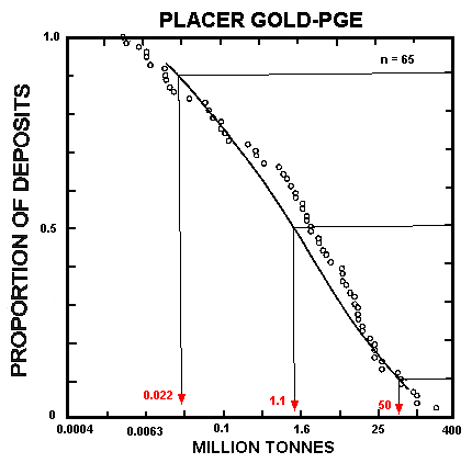
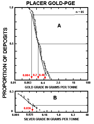
Placer sizes were initially recorded in terms of cubic meters and the grades recorded as grams per cubic meter. In order to conform to other deposit models herein, deposit volume and grades have been converted to metric tons and grams per metric ton using 2.0 metric tons per cubic meter--the average density of wet sand and gravel. Gold grade is correlated with tonnage (r = -0.35) and with silver grade (r = 0.66, n = 16). See figs. 196, 197.
Figure 196. Tonnages of placer Au-PGE deposits. Individual digits represent number of deposits. [Because of limitations on the reproduction of the original figure, these numbers cannot be distinguished in the figure.]
Figure 197. Precious-metal grades of placer Au-PGE deposits. A, Gold. B, Silver.
DEPOSITS
Name Country
Adelong Creek AUNS
Alma (Mills) Placer USCO
Araluen Valley AUNS
Bannack USMT
Big Badja River AUNS
Blue River USCO
Boulder River USMT
Bullrun Placer USOR
Buxton Creek CNBC
Camanche USCA
Cobweb Diggings AUNS
Copper Basin USAZ
Corduroy Creek USID
Crooked Creek USID
Cullengoral AUNS
Deep Gravel USOR
Dixie Placer USOR
El Dorado USMT
Elkhorn Creek USMT
Elliston USMT
Fall Creek USID
Foots Creek USOR
Forest Creek USOR
French Gulch USCO
George Prezel USID
Georgia Gulch USCO
Gold Run (Summit Co.) USCO
Gold Run (Boulder Co.) USCO
Golden Rule USID
Green River USUT
Horse Praire USMT
Humbug Creek USOR
Hundred Dollar Gulch USID
Iowa Gulch USCO
Jembaicumbene Creek AUNS
Jordan Creek USID
Lamb Creek USID
Llano de Oro USOR
Lowe Placer USCO
Lower Beaver Creek USCO
Lowland Creek USMT
Lynx Creek USAZ
Missouri Creek USCO
Mitchell Creek USMT
Nugget Creek (South Fork) USID
Ophir USMT
Pactolus USCO
Picuris USNM
Pioneer USMT
Prickly Pear Creek USMT
Rio Challana BLVA
Rio Chimate BLVA
Rio Tuichi (upper reach) BLVA
Rio Yolosano BLVA
Rio Yuyo BLVA
Sand Creek USID
Schissler Creek USID
Snowstorm area USCO
Sterling Creek USOR
Sumpter Bar USOR
Swan River USCO
T93-R77W Placer USCO
Vermilion River USMT
Wellington AUNS
Wombat Creek AUNS