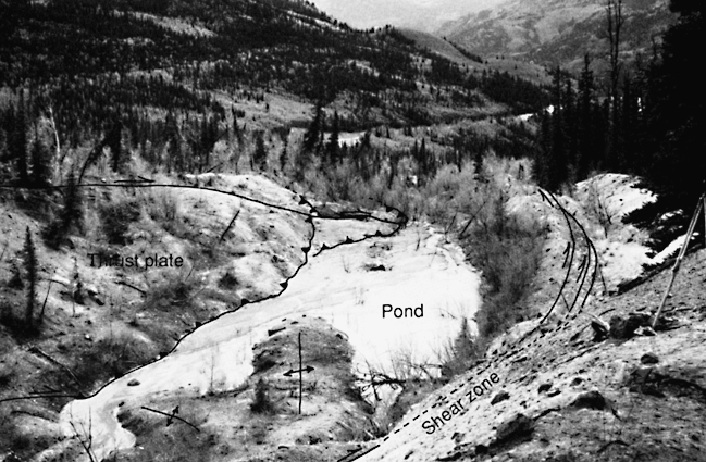
Figure 2.--Pull-apart basin at step in right flank of the landslide (about 10850 N., 8850 E., see figure 1 for location). Annotated view looking downslope along right flank about 300 m below the narrowest part of the active landslide. Here, the landslide abruptly becomes wider. The right-lateral strike-slip shear zone on the landslide boundary is in the trough in the lower middle and curves along the right side of the view. The landslide widens at this step in the flank and others like it (fig. 1). Shown here are the typical structures formed in the downslope end of the widening section. We call the overall structure a pull-apart basin because of similarities to such basins in tectonic settings. Solid lines indicate visible active traces of the bounding faults, and dashed lines indicate projected traces where faults are obscured. The basin contains a pond, which is interrupted by two linear protrusions (shown by anticline symbols) that are apparently compressional features formed by movement of material into the pull-apart structure. The basin is filled in this lower (southwestern) part by material moving obliquely from left to right along strike-slip faults. The strike-slip faults in the interior of the slide are approximately parallel to the axis of the landslide near the upper (northeastern) part of the basin, but they curve toward the boundary in the lower part. These faults terminate in thrust faults that extend nearly to the landslide margin. Two of these strike-slip faults and some of the thrust faults are annotated. Note that the small trees on the thrust plate have been tilted toward the landslide flank; continued vertical growth of the tip of the trees has resulted in a bow shape convex toward the flank.

![]() U.S. Department of the Interior |
U.S. Geological Survey
U.S. Department of the Interior |
U.S. Geological Survey
URL: http://pubsdata.usgs.gov/pubs/bul/b2130/ch2fig2.htm
Page Contact Information: GS Pubs Web Contact
Page Last Modified: Friday, 23-Mar-2012 14:25:13 EDT