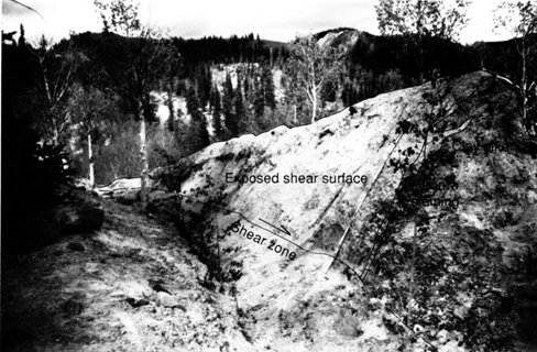
Figure 3.--Annotated view looking upslope at flank ridge on right flank of the landslide (about 10530 N., 8370 E., Tape is 2 m long. See figure 1 for location). A 1.5-m-wide transverse crack exposes a cross-sectional view of the ridge (dark area surrounded by clay dike and the hachured line). Landslide material in the exposed face is stony, heterogeneous, and has a blocky structure. Near the left side of the ridge, the fracture surfaces defining the blocky structure are iron stained. A scarp at the outboard side of ridge (light area at center) exposes an emergent part of the lateral shear surface. This shear surface is between the crest and the trace of the right-lateral shear zone (shown by a solid line where the trace is visible, dashed where obscured). The scarp tapers from a height of about 2 m in foreground to 0 m in the background (about 20 m upslope). The taper is consistent with screw-like movement along this part of the flank; the ridge growth is about 0.1 meter per meter of downslope of displacement. Annual movement here is about 3.5 m. The scarp is convex and is covered with sheared, highly plastic, blue-gray clay (liquid limit = 105, plasticity index = 77) that differs in color and texture from the stony, light-brown landslide material in the ridge. Movement at the shear zone has brought a tabular dike of blue-gray clay to the surface and injected the clay into the landslide materials. The double line on the light-colored side of the ridge shows the 5- to 10-cm thickness of blue-gray clay that has been intruded along the shear zone and into the ridge.

![]() U.S. Department of the Interior |
U.S. Geological Survey
U.S. Department of the Interior |
U.S. Geological Survey
URL: http://pubsdata.usgs.gov/pubs/bul/b2130/ch2fig3.htm
Page Contact Information: GS Pubs Web Contact
Page Last Modified: Friday, 23-Mar-2012 14:25:12 EDT