


Irrigation water-use data are used to manage finite ground-water supplies and often over-appropriated surface-water supplies. For example, Congress mandated*1. a study of the High Plains aquifer in the central United States to determine if it is being depleted. Also, the U.S. Bureau of Reclamation is required (Public Law 90-537) to monitor consumptive uses and losses of the much-used water resources in the Colorado River Basin (U.S. Bureau of Reclamation, 1981). In addition, many states have established various kinds of water-management districts to manage specific water sources that have been identified as critical.
Figure 8. Diagram of irrigation water use.
Water used for irrigation is diverted or withdrawn from natural stream
flow, aquifers, and springs. Much of this withdrawn water is stored in
open reservoirs that also serve other uses such as recreation, flood
protection, flow regulation, and hydropower generation and allow
managers to deliver water at times of need. Surface-water-delivery
systems include natural and man-made channels and pipelines.
Reservoirs, unlined ditches, and canals have significant consumptive
use through evaporation, bank storage, and return flow to ground water
through leaky structures and porous soils. Ground water is used where
surface supply is not economically or physically available or when
better water quality is required. The costs associated with locating
aquifers, drilling wells, and pumping may make ground water more
expensive. Thus, ground-water-delivery systems are designed to
minimize losses through closed pipeline systems.
Four irrigation methods are used throughout the United States
including surface, sprinkler, micro, and subsurface. The most
comprehensive reference recently published is the Management of Farm
Irrigation Systems, ASAE Monograph (Hoffman, Howell, Solomon, 1990).
Reports by Jensen (1983), and Withers and Vipond (1980) are just a few
of the references that describe some of the many types of irrigation
systems. The U.S. Bureau of the Census (1982, 1990) periodically
surveys irrigation methods used throughout the nation.
Consumptive use of irrigation water occurs as (1) evaporation from
open reservoirs and conveyances and during application to plants, (2)
evapotranspiration during plant growth, and (3) product
incorporation. Because total consumptive use in the irrigation
category is larger than any other category, it is important to obtain
or estimate accurate consumptive-use information when withdrawal and
diversion data are collected or estimated.
Agricultural extension agents should be able to provide information on
the types of irrigation systems and irrigated crops in the area. They
may be able to estimate irrigated acreage and irrigation methods and
assist in the development of a crop calendar. A crop calendar
includes information on the types of irrigated crops, planting and
harvesting dates, and periods of plant growth. It is used for
inventorying irrigated-crop acreages and monitoring irrigation-system
use by providing a timetable for scheduling data collection during the
growing season. This information also can be obtained from county
agents and State agricultural agencies. Researchers at Universities
and Colleges of Agriculture, especially land-grant universities, and
Agricultural research stations can provide assistance and answer any
questions dealing with irrigation including crop-water demand figures,
soil information, and water-use information.
The U.S. Bureau of the Census is authorized by Congress (Title 13 of
the United States Code--section 182) to conduct surveys deemed
necessary to furnish annual or other data on the subject covered by
the census. Selected irrigation data for on-farm irrigation have been
collected in the census of agriculture since 1890. A census of farms
reporting irrigation in the 1900 Census of Agriculture was authorized
by Congress. Surveys of irrigation in humid areas were taken in
connection with the 1954 and 1959 censuses. The 1988 Farm and Ranch
Irrigation Survey (US Bureau of the Census, 1990) is the third survey
devoted entirely to the collection of on-farm irrigation for the
conterminous United States. The 1979, 1984, and 1988 Farm and Ranch
Irrigation Surveys collected similar data using similar methods and
procedures of data collection and processing.
The NRCS assists farmers with their irrigation problems through about
2,500 field offices. They work with about 278,000 farmers making
on-farm irrigation evaluations including estimates of water use. The
National Agricultural Statistical Service (NASS), in cooperation with
the Department of Agriculture in each State, also collects annual crop
and livestock statistics and irrigated-land crop data for many of the
states where irrigation is used extensively.
Irrigation equipment dealers can provide information about the types
of systems they sell and the types that are used regionally. Dealers
are a valuable source of information, since they can describe the
actual systems that are seen in the field. They can determine
equipment design specifications such as the capacities of certain
center pivot systems. These specifications are needed for analyzing
inventory data. Many types of irrigation systems can be inspected at
the dealerships. U.S. Bureau of Reclamation publication Summary
Statistics: Water, Land, and Related Data is also useful source of
agriculture data.
Surface-water irrigation systems rely on water diverted or pumped from
a river, stream, lake, or reservoir. Water pumped from a
surface-water source can be measured using the methods described in
Chapter 1 of this National Handbook of Recommended Methods.
Surface-water withdrawals can be determined by measuring flow in the
diversion (the point where water is withdrawn from the stream) or by
measuring the flow upstream and downstream from the diversion when the
diversion is a significant part of the flow. Similarly, return flow
can be determined by measuring flow at the point of discharge into the
stream or measuring the flow upstream and downstream of the discharge.
The difference between withdrawals and return flow is consumptive use,
which consists of evaporation, deep percolation, and
evapotranspiration by and incorporation into the plant. Methods for
measuring and estimating ground-water pumpage are discussed in Chapter
2 of this National Handbook of Recommended Methods for Water-Data
Acquisition.
Conveyance loss (evaporation and seepage) can be measured after the
return flow of one user and before the withdrawal of the next
user. Conveyance loss also can be measured by determining the loss
attributable to canal seepage and adding an estimate of evaporation.
Several methods commonly are used to measure canal seepage. These
include ponding tests, inflow-outflow studies, and seepage-meter
studies.
Ponding tests give the most reliable results. To conduct a ponding
test (Rohwer, 1948), a section of canal is blocked off with dams at
each end and filled with water to, or slightly higher than, the level
at which it usually flows during the irrigation season. As the water
level in the canal section declines, the time is recorded and a
seepage rate determined. Necessary corrections for temperature and
evaporation are made and the seepage loss-rate computed. Ponding
tests are usually conducted during the nonirrigation season, and are
applied in a nonflow situation in which actual flow conditions are not
being met. This is discussed in more detail by Rohwer (1948).
Inflow-outflow studies are conducted using long reaches of the canal
and require the least extrapolation of the three methods. However,
the inaccuracy of an inflow-outflow measurement is proportionate to
the total flow in the canal, and can be a much larger value than the
amount of seepage that occurs in a reach that has little seepage.
Inflow-outflow studies using discharge measurements are described in
detail by Rantz and others (1982). One of the major advantages of
using the inflow-outflow method is that it can be applied during the
irrigation season.
Seepage meters sometimes are used to determine seepage rates at
certain locations on the canal. Obtaining a tight seal on the canal
bottom or sides, however, is a problem; therefore, the use of seepage
meters is not appropriate in canals with rocky or rubbly perimeters or
in canals with flow velocities faster than 2 feet per second. Because
seepage rates may vary considerably from point to point, many
measurements need to be made throughout the length of the canal to
achieve an acceptable average value. Seepage meters probably are most
helpful in determining rates at specific locations along the canal,
and in determining relative seepage rates at different
locations. Seepage meters probably are best used while the canal is in
operation. However, because of variable and sometimes erratic values
obtained in measurements using the seepage meters, they are seldom
used.
In order to extrapolate seepage measurements throughout the evaluation
area, the canal system needs to be adequately described. Reaches need
to be classified by soil type, conveyance properties (mean flow,
wetted perimeter, and slope), and geohydrologic setting. Generally,
soil type and conveyance properties are known, but the
geohydrologic-setting analysis commonly is inadequate. The hydraulic
conditions under which canal seepage occurs needs to be specifically
determined for test reaches, and at least qualitatively estimated for
the remainder of the canal system. Basically, two hydraulic
conditions may be present in the canal system: (1) If the water table
intersects the canal prism, the pore water in the bank material of the
canal will be under positive pressure (greater than atmospheric), and
the seepage rate will be controlled by the rate of water flowing in
the saturated part of the aquifer; and (2) if the pore water in the
bank material of the canal is under atmospheric or negative pressure,
the seepage rate will be controlled by the hydraulic properties of the
bank material and the gradient underlying the canal. Because the
transmissivity of the bank material is greater than the transmissivity
of the aquifer, seepage will be greater for the bank material than for
the water-table condition. The geohydrologic setting can be
determined by use of transects of piezometers or wells or both. If the
geohydrologic setting is not the same during the seepage test as
during normal operation of the canal, use of test results to estimate
annual seepage loss is not appropriate.
Maps for use in determining irrigated acres can be obtained from State
agencies (such as the Department of Agriculture, Department of Natural
Resources, Department of Transportation or Topographic Offices) and
the U.S. Geological Survey. Parcels of land and their owners are
recorded in plat books that can be obtained from county
agencies. Aerial photographs may be available from numerous sources
including State agencies, the NRCS, the U.S. Agricultural
Stabilization and Conservation Service, the National Aeronautics and
Space Administration, and local colleges or universities.
Field-specific irrigated acres by crop type are more difficult to
obtain. Many government agencies may keep records of irrigated acres
by county, or by grower (for various purposes) but field-level data
may be less frequently available. Federal, State, and local agencies
including the U.S. Bureau of the Census, the National Resource
Conservation Service, the U.S. Agricultural Research Service, State
agencies (engineers, water, agriculture, natural resources, and
environmental departments), county assessors, and the County Extension
Service are all potential sources of irrigated acreage information.
Irrigated acreage usually is estimated through a sample survey or
complete census. Estimates of irrigated acreage can vary
significantly, depending on the method used to collect the data and
the purpose for which the information is needed. For example, one
value may be reported to the State engineer for water-rights purposes
and another value may be reported to the county assessor for tax
purposes. A third value may be determined for a Federally sponsored
farm subsidy program, and the local county extension agent may
estimate an entirely different number. Thus, agency totals generally
do not match. To overcome this problem, some States have formed
water-use data work groups. These work groups compare estimates of
irrigated acreages and attempt to resolve the differences. An
additional benefit of forming work groups is for the establishment of
statewide, or basinwide, computerized data bases. Irrigated acres and
irrigable acres can be mapped and stored in geographic information
system (GIS) data bases. The data base can be developed, updated, and
accessed by all agencies requiring the information. All updates can
be coordinated through and certified by the work group.
Remote sensing can be used to estimate irrigated acres. Remote
sensing includes high- or low-altitude aerial photography or satellite
imagery. Timing of the photographs or images is critical in
determining actual acres irrigated. If taken too early, areas affected
by shallow ground water from spring runoff are difficult to separate
from areas where irrigation water is applied. If taken late in the
season, harvesting may have been completed for some crops. In areas
where successive crops are grown on the same land, more than one set
of images may be needed. In some areas, cloud cover also may be a
problem. Identification of specific crops from imagery is often
uncertain and field surveys may be required to verify the accuracy of
crop determination. Uncertainty in crop determination is frequent in
areas where a large variety (more than 200) crops are grown that may
appear similar in aerial photographs. Reliability in the use of aerial
photography is increased in areas where crop variations are minimal,
or if these tools are only used to determined general cropped or
irrigated acreages. In general, use of computer-processed Landsat
data to identify irrigated crop types and estimate crop acreage is
more successful in arid and semiarid lands where crop diversity is
minimal, dryland crop production is minimal, soils are warm and well
drained, crop calendars are more diverse temporally, and fields are
planted entirely and with one crop type (Kolm, 1985).
The U.S. Bureau of Reclamation in Denver, Colorado developed
techniques for monitoring of irrigated lands using combined remote
sensing and GIS programs. To develop accurate, annual irrigation
information, field boundaries were determined at the 1:24,000 scale
through manual photo-interpretation of infrared high-altitude
photography. Irrigation status also was determined through manual
photointerpretation. The information was determined to be accurate at
a level of 99.99 percent through random field checking. Irrigated
acreage was updated from year to year by overlaying the field-boundary
maps with current Landsat Thematic Mapper imagery. This method
provided an inexpensive, annual updating of the data base while
retaining the accuracy of acreage estimates inherent in the
large-scale field-boundary maps. This information was then
incorporated into a GIS for use as a management tool (Verdin and
others, 1986). Field boundaries and 1987 irrigation status were
transferred into ARCINFO (a proprietary geographic information system)
for further processing. Additional data layers for the elevation,
crops, precipitation, and temperature were added to allow calculation
of irrigation-water requirements using the modified Blaney-Criddle
method (U.S. Department of Agriculture, 1967). Additional water-use
data bases (water rights, ditch withdrawal points, streams, and
reservoirs) also were linked to the ARCINFO database to provide water
managers with a geographically referenced management tool.
After the number of irrigated acres has been determined by crop type,
a value for the volume of water applied per acres is required.
Development of an application rate incorporates crop water
consumption, precipitation rates, and local irrigation practices.
Local universities and county extension agents may have good estimates
for crop water consumption. The U.S. Department of Agriculture (1976)
published a report that provides consumptive irrigation requirements
by crop type and by subareas within each state. The NRCS in 1994
published the National Engineering Handbook, Part 623, Chapter 2-
"Irrigation Water Requirements". It describes the use of four methods
for estimating crop consumptive use, depending on availability of data
and geographic and climatic conditions. It also includes the modified
Blaney-Criddle method in the appendix. Water application rates and
crop consumption also can be developed through field work.
Development of an irrigation water application coefficient may begin
with an irrigation survey, possibly coordinated with an interested
State or local agency. After assimilating and evaluating all of the
background information, a plan is developed for grouping irrigation
sites by common characteristics, determining (1) the sample size for
each group or strata, (2) what data to collect, and (3) the
instrumentation for measuring flow or pumping rate and duration. The
plan is based on the background information plus the availability of
funding and the size of the work force.
After the plan is developed, individual landowners and farmers are
randomly selected and contact to obtain permission to collect the
necessary information. During the initial contact, farmers can be
interviewed to obtain answers to questions on the inventory form. The
farmer usually is the best source of information for the
inventory. See Shoemyen (1979) for suggestions. An inventory form is
developed to collect the necessary water-use information and provides
the format for the data storage and retrieval system. Shoemyen (1979)
provides guidance in developing an inventory form. The form needs to
include information on crop types, irrigation systems, and owners of
the systems. The rate of return for the forms depends on the publicity
associated with the survey and the consequences of
noncompliance. Accuracy of the information supplied on the survey
forms also may vary, depending upon the equipment that is available to
the farmers and the record-keeping practices of each farmer. Rate of
return and accuracy can be increased by follow-up visits to or
telephone contacts with the farmers.
Irrigation water use or water application coefficient can be estimated
from the power used during pumping by use of data on total power
consumption and an estimate for the average number of kilowatt hours
required to pump an acre-foot of water (unit power consumption). In a
pilot study designed to explore costs and procedures for calculating
ground-water pumpage, Ogilbee (1966, p. 17-31) compared nine
variations of three basic approaches for estimating irrigation water
use. He concluded that the most convenient and reliable technique is
to use total power consumption and annual mean unit power consumption
to compute estimates of pumpage. Sandburg (1966) and Hurr and Litke
(1989) used this approach for areas where it is impractical or too
costly to equip all wells with totalizer flow meters; for these areas,
the total volume of ground water withdrawn may be determined by use of
energy-consumption data. In this approach, pumping-plant installations
are grouped or stratified according to area, aquifer, irrigation
method, crop type, and availability of surface water, and then the
pumping-plant installations are sampled. Data on power consumption and
pumping rate and duration are collected for each of the installations
in the sample. Power consumption data were obtained through reading
energy meters. At pumping plants powered by electricity, the
calculations were modified if transformers were present. At pumping
plants powered by natural gas, the effects of the pressure-correction
factor were included in the calculations. At pumping plants powered by
gasoline, diesel oil, or liquid petroleum gas, the geometry of storage
tanks were analyzed as part of the calculation. The power consumption
and pumping rate and duration were used to determine the power
consumption coefficient that will convert the volume of the energy
consumed by that installation into the equivalent volume of water
pumped during a given period. This is done for each of the
installations in the sample. A mean conversion factor is then
calculated for each group. The total power use for all users in each
group is obtained from the power company and then multiplied by the
conversion factor developed for that group to determine an irrigation
water-use estimate. Where equipment and hydrologic conditions are
stable, this coefficient were applied to total energy consumption at a
site to estimate total ground-water withdrawals. Random sampling of
power-consumption coefficients was used to estimate area-wide
ground-water withdrawals.
A water application coefficient should be developed for each group or
strata of irrigators. Important variables, such as crop type, system
type, and precipitation, as well as slope and soil type, should be
analyzed to determine their significance to the application rate. The
water application rate can be adjusted to variations in crop type and
precipitation rates for future irrigation estimates.
In general, the difference between withdrawals and return flow equals
consumptive use. In irrigation water use, return flow has a surface
water (including overland flow to the stream) and a ground-water
component. Irrigation water returning via canal or ditch to the
surface-water system can be measured using standard methods.
Irrigation water returning to the ground-water system and through the
soil to the surface-water system, such as through canal seepage,
excess water applied to the field, is much more difficult to quantify.
Intensive ground-water studies or water-balance studies may be needed
to accurately estimate ground-water return flows.
Nationally, conveyance losses and consumptive use in irrigation
account for 76 percent of irrigation withdrawals (Solley and others,
1993); therefore, estimates of conveyance losses and consumptive use
are important. Estimating conveyance loss and consumptive use
incorporates the following relations:
Crop irrigation requirement + irrigation efficiency (AL and RF) =
irrigation water requirement (4)
Irrigation water requirement + conveyance losses (evaporation and
seepage) = withdrawals (5)
Asano, Takashi, and Pettygrove, G.S., 1984, Irrigation with reclaimed
wastewater, a guidance manual: California State Water Resources
Control Board, 15 chapters, 9 appendixes.
Baker, C.H., Jr., 1983, Evaluation of techniques for estimating
ground-water withdrawals for irrigation in western Kansas: Kansas
Water Office Bulletin 26, 14 p.
Blaney, H.F., and Criddle, W.D., 1950, Determining water requirements
in irrigated areas from climatological and irrigation data: U.S. Soil
Conservation Service Technical Paper 96, 48 p.
-----1962, Determining consumptive use and irrigation water
requirements: U.S. Department of Agriculture Technical Bulletin
No. 1275, 59 p.
-----1966, Determining consumptive use for water planning
developments: Los Angeles, University of California, Water Resources
Center, 35 p.
Bollman, F.H., 1977, Forecasting water demands for planning
in Irrigation and Drainage Division Speciality Conference on
Water Management for Irrigation and Drainage, Reno, Nev., July 20-22,
1977, Proceedings: Reno, Nev., American Society of Civil Engineers,
p. 143-155.
Bos, M.G., Repogle, J.A., and Clemmens, A.J., 1984, Flow measuring
flumes for open channel systems: New York, John Wiley.
Brosz, D.J., 1966, Irrigation water measurement (A handbook for ditch
riders and irrigators): U.S. Department of Agriculture, Mountain
States Regional Cooperative Extension Service Circular 132-revised, 55
p.
Clawges, R.M., and Titus. E.O., 1993, Method for predicting water
demand for crop uses in New Jersey in 1990, 2000, 2010, and 2020, and
for estimating water use for livestock and selected sectors of the
food-processing industry in New Jersey in 1987: U.S. Geological Survey
Water-resources Investigations Report 92-4145, 211 p.
Diamond, Jonathan, and Williamson, A.K., 1983, A summary of
ground-water pumpage in the Central Valley, California, 1961-77:
U.S. Geological Survey Water-Resources Investigations Report 83-4037,
70 p.
Doorenbos, J., and Pruitt, W.O., 1977, Guidelines for predicting crop
water requirements: Food and Agricultural Organization, Irrigation and
Drainage Paper no. 24, 144 p.
Duerr, A.D., and Trommer, J.T., 1982, The benchmark farm program--a
method for estimating irrigation water use in southwest Florida:
U.S. Geological Survey Water-Resources Investigations Report 82-17, 49
p.
Erie, L.J., French, O.F., Bucks, D.A., and Harris, K., 1982,
Consumptive use of water by major crops in the Southwestern United
States: U.S. Department of Agriculture, Agriculture Research Service
Conservation Research Report no. 29, 40 p.
Finkel, H.J. (ed.), 1983, Handbook of irrigation technology: Haifa,
Israel, CRC Press.
Gilley, J.R., 1977, Computer modeling to maximize water-use efficiency
and reduce energy in irrigation: Lincoln, University of Nebraska,
Water Resources Research Institute, Completion Report PB-275 776, 30
p.
Gisser, Micha, and Mercado, Abraham, 1972, Integration of the
agricultural demand function for water and the hydrologic model of the
Pecos basin: Water Resources Research, v. 8, no. 6, p. 1373-1384.
Gregory, E.J., and Hanson, E.G., 1979, Predicting consumptive use with
climatological data: New Mexico Water Resources Research Institute
Report no. 66.
Hansen, V.E., Israelsen, O.W., and Stringham, G.E., 1980, Irrigation
principles and practices: New York, Wiley, 4th ed., 417 p.
Heady, E.O., and Nicol, K.J., 1975, Models of agricultural water, land
use and the environment, in North-Holland/Tims Studies in the
Management Sciences: New York, North-Holland Publishing Co., v. 3,
p. 29-56.
Hedlund, J.D., and Koluvek, P.K., 1985, Rating system to evaluate
on-farm water conservation in Irrigation and Drainage
Division Specialty Conference on Development and Management Aspects of
Irrigation and Drainage Systems, 1985, Proceedings: American Society
of Civil Engineers, p. 137-145.
Heimes, F.J., and Luckey, R.R., 1980, Evaluating methods for
determining water use in the High Plains in parts of Colorado, Kansas,
Nebraska, New Mexico, Oklahoma, South Dakota, Texas, and Wyoming,
1979: U.S. Geological Survey Water-Resources Investigations Report
80-111, 118 p.
-----1982, Methods for estimating historical irrigation requirements
from ground water in the High Plains aquifer in parts of Colorado,
Kansas, Nebraska, New Mexico, Oklahoma, South Dakota, Texas, and
Wyoming: U.S. Geological Survey Water-Resources Investigations Report
82-40, 64 p.
-----1983, Estimating 1980 ground-water pumpage for irrigation on the
High Plains in parts of Colorado, Kansas, Nebraska, New Mexico,
Oklahoma, South Dakota, Texas, and Wyoming: U.S. Geological Survey
Water-Resources Investigations Report 83-4123, 36 p.
Heimes, F.J., Luckey, R.R., and Stephens, D.M., 1986, Evaluation of
sampling methods used to estimate irrigation pumpage in Chase, Dundy,
and Perkins Counties, Nebraska, 1975-83: U.S. Geological Survey
Water-Resources Investigations Report 86-4092, 27 p.
Heimes, F.J., and Thelin, G.P., 1979, Development and application of
Landsat-derived irrigation cropland maps for water-use determination
in the High Plains, in Identifying irrigated lands using remote
sensing techniques--State-of-the-art symposium: U.S. Geological
Survey-Earth Resources Observation System Data Center, Proceedings,
p. 76-77.
Hiler, E.A., 1975, Increased water use efficiency through trickle
irrigation: Texas Water Resources Institute, Technical Report 65, 72
p.
Hiler, E.A., and Howell, T.A., 1974, Optimization of water use
efficiency through trickle irrigation and the stress day index:
College Station, Texas A and M University, Texas Water Resources
Institute, Technical Report 62, 229 p.
Hoffman, R.O., Edwards, D.M., Wallin, G., and Burton, T., 1974, Remote
sensing instrumentation and methods used for identifying center pivot
sprinkler irrigation systems and estimated crop water use, in
International seminar and exposition on water resources
instrumentation, Volume 1--Measurement and sensing methods, Chicago,
Ill., 1974, Proceedings: International Water Resources Association,
p. 312-317.
Hoffman, R.O., Howell, T.A., and Solomon, 1990, Management of Farm
Irrigation Systems, American Society of Agricultural Engineers,
Monograph.
Hurr, R.T., and Litke, D.W., 1989, Estimating pumping time and
ground-water withdrawals using energy-consumption data:
U.S. Geological Survey Water-Resources Investigations Report 89-4107,
27 p.
Israelsen, O.W., and Stringham, G.E., 1984, Irrigation principles and
practices, 4th ed.: New York, John Wiley, 450 p.
Jensen, M.E., 1983, Design and operation of farm irrigation systems:
American Society of Agriculture Engineers, Monograph 3, St. Joseph,
Mich., 829 p.
Jensen, M.E., Burman, R.D., and Allen, R.G. (eds.), 1990,
Evapotranspiration and irrigation water requirements: New York,
American Society of Civil Engineers, Manual and Reports on Engineering
Practice no. 70, 332 p.
Jensen, M.E., and Haise, H.R.,1963, Estimating evapotranspiration from
solar radiation: American Society of Civil Engineers, Journal of the
Irrigation and Drainage Division, Proceedings, v. 89, p. 15-41.
Kolm, K.E., 1985, Evaluation of techniques for mapping land and crops
irrigated by center pivots from computer-enhanced landsat imagery in
part of the James River basin near Huron, South Dakota:
U.S. Geological Survey Water-Resources Investigations Report 85-4021,
24 p.
Leake, S.A., 1984, A method for estimating ground-water return flow to
the Colorado River in the Parker area, Arizona and California:
U.S. Geological Survey Water-Resources Investigations Report 84-4229,
31 p.
Loeltz, O.J., and Leake, S.A., 1983, A method for estimating
ground-water return flow to the lower Colorado River in the Yuma area,
Arizona and California: U.S. Geological Survey Water-Resources
Investigations Report 83-4220, 86 p.
Luckey, R.R., 1972, Analyses of selected statistical methods for
estimating ground-water withdrawal: Water Resources Research, v. 8,
no. 1, p. 105-210.
Luckey, R.R., Heimes, F.J., and Gaggiani, N.G., 1980, Calibration and
testing of selected portable flowmeters for use on large irrigation
systems: U.S. Geological Survey Water-Resources Investigations Report
80-72, 21 p.
Maidment, D.R., 1977, Systems analysis applied to agricultural water
demands, in International Institute for Applied Systems
Analysis Workshop on Water Demands, Laxenburg, Austria, 1977,
Proceedings: International Institute for Applied Systems Analysis,
p. 47-56.
Maidment, D.R., Lewthwaite, W.J., and Hamblett, S.G., 1980, Rakaia
water use and irrigation development for natural water and soil
conservation: Wellington, New Zealand, Water and Soil Division,
Ministry of Works and Development, Miscellaneous Publication 19, 47
p.
Marella, R.L., and Singleton, V.D., 1988, Metering methods and
equipment used for monitoring irrigation in the St. Johns River Water
Management District: Fl., St. Johns River Water Management District,
Department of Water Resources, p. 17.
Moore, C.V., 1961, A general analytical framework for estimating the
production function for crops using irrigation water: Journal of Farm
Economics, v. 43, no. 4, p. 876-888.
-----1972, On the necessary and sufficient conditions for a long-term
irrigated agriculture: Water Resources Bulletin, v. 8, no. 4,
p. 802-812.
Moore, C.V., Snyder, J.H., and Sun, Peter, 1974, Effects of Colorado
River water quality and supply on irrigated agriculture: Water
Resources Research, v. 10, no. 2, p. 137-144.
Ogilbee, William, 1966, Progress report--Methods for estimating
ground-water withdrawals in Madera County, California: U.S. Geological
Survey Open-File Report, 32 p.
Owen-Joyce, S.J., 1984, A method for estimating ground-water return
flow to the Colorado River in the Palo Verde-Cibola area, California
and Arizona: U.S. Geological Survey Water-Resources Investigations
Report 84-4236, 48 p.
Phillips, T.L. (ed.), 1973, LARSYS user's manual: West Lafayette,
Penn., Purdue University, Laboratory for Applications for Remote
Sensing, 958 p.
Raymond, L.H., and Rezin, K.V., 1986, Evapotranspiration estimates
using remote-sensing data, Parker and Palo Verde Valleys, Arizona and
California: U.S. Geological Survey Open-File Report 86-87, 33 p.
Rada, E.L., and Berquist, B.J., 1976, Irrigation efficiency in the
production of California crop calories and proteins: Davis, University
of California, Water Resources Center, 69 p.
Rantz, S.E., and others, 1982, Measurement and computation of
streamflow: U.S. Geological Survey Water Supply Paper 2175, v I and v
2, 631 p.
Replogle, J.A., and Clemmens, A.J., 1980, Constructing simple
measuring flumes for irrigation canals: U.S. Department of
Agriculture, Science and Education Administration, Farmers Bulletin
No. 2268, 13 p.
Robinson, A.R., 1959, Measuring seepage from irrigation canals:
U.S. Department of Agriculture, Agricultural Research Service,
Technical Bulletin 1203, 82 p.
Robinson A.R., Lauritzen, C.W., Muckel, D.C., and Phelan, J.T., 1963,
Distribution, control, and measurement of irrigation water on the
farm: U.S. Department of Agriculture, Publication no. 926, 27 p.
Rohwer, Carl, 1948, Seepage losses from irrigation channels: Fort
Collins, Colo., A and M College, Technical Bulletin 38, 98 p.
Sandberg, G.W., 1966, Two simplified variations of a method for
computing ground-water pumpage: U.S. Geological Survey Water-Supply
Paper 1822, p. 114-117.
Scherer, C.R., 1977, Water allocation and pricing for control of
irrigation-related salinity in a river basin: Water Resources
Research, v. 13, no. 2, p. 225-238.
Schleusener, P.E., and Sulek, J.J., 1959, Criteria for appraising the
performance of irrigation pumping plants: Agricultural Engineering,
v. 409, no. 9, p. 550-551.
Scott, V.H., and Houston, C.E., 1959, Measuring irrigation water:
Davis, California Experiment Station, Extension Service, Circular 473,
52 p.
Seginer, Ido, 1967, Net losses in sprinkler irrigation: Agricultural
Meteorology, v. 4, p. 281.
Shoemyen, J.L. (ed.), 1979, Procedure for assessing agricultural water
use: Suwannee River Water Management District, Department of Planning
and Operations, 114 p.
Sowell, R.S., Sneed, R.E., and Chen, L.H., 1976, Agricultural water
demands in North Carolina: Raleigh, University of North Carolina,
Water Resources Research Institute Report no. 114, 52 p.
Stout, G.E., 1983, Efficient use of water for irrigation in the upper
Midwest: Urbana, University of Illinois, Water Resources Center,
Report 176, 57 p.
Texas Technical College Agricultural Engineering Department, 1968,
Power requirements and efficiency studies of irrigation pumps and
power units: Lubbock, Tex., 79 p.
Thelin, G.P., and Heimes F.J., 1987, Mapping irrigated cropland from
Landsat data for determination of water use from the High Plains
aquifer in parts of Colorado, Kansas, Nebraska, New Mexico, Oklahoma,
South Dakota, Texas, and Wyoming: U.S. Geological Survey Professional
Paper 1400-C, 38 p.
Upper Colorado Region State-Federal Inter-Agency Group, Pacific
Southwest Inter-Agency Committee, and Water Resources Council, 1971,
Upper Colorado region comprehensive framework study--Appendix 10,
Irrigation and drainage: p. 98.
U.S. Bureau of the Census, 1982, Census of agriculture--1987,
Irrigation, v. 4: U.S. Government Printing Office, 330 p. (available
every 5th year since 1949).
-----1990, Farm and ranch irrigation survey (1988), 1987 census of
agriculture, Related surveys, v. 2, part 1: U.S. Bureau of the Census,
Special Report Series AC 87-RS-1, 114 p.
U.S. Bureau of Reclamation, 1981, Colorado River system consumptive
uses and losses report, 1976-80: Salt Lake City, Utah, 41 p.
U.S. Department of Agriculture, 1962, Determining consumptive use and
irrigation water requirements: Agricultural Research Service Technical
Bulletin 1275, 59 p.
-----1967, Irrigation water requirements: U.S. Soil Conservation
Service, Engineering Division Technical Release no. 21, 88 p.
-----1973, Soil Conservation Service National Engineering Handbook -
Section 15, Irrigation, Chapter 9, Measurement of irrigation water: 72
p.
-----1976, Crop consumptive irrigation requirements and irrigation
efficiency coefficients for United States: U.S. Soil Conservation
Service, Special Project Division, 141 p.
-----1983, Soil Conservation Service National Engineering Handbook -
Section 15, Irrigation, Chapter 11, Sprinkler Irrigation: 121 p.
-----Economic Research Service, 1986, 1984 farm and ranch irrigation
survey: Special Report AG84-SR-1.
-----1994, Soil Conservation Service National Engineering Handbook -
Part 623, Chapter 2, Irrigation Water Requirements: 121 p.
U.S. Department of the Interior, U.S. Department of Agriculture and
U.S. Environmental Protection Agency, 1979, Irrigation water use and
management: An interagency task force report, 133 p.
U.S. Federal Energy Administration, 1976 (v. 1), 1977 (v. 2), Energy
and U.S. Agriculture--1974 data base: Report nos. FEA/D-76/459, FEA/D-
77/140.
Van Deman, J.M., Sowell, R.S., and Sneed, R.E., 1976, Optimization of
water use for irrigation: American Society of Agricultural Engineers,
Chicago, December 14-17, Paper no. 76-2526, 20 p.
Verdin J.P., Crane, M.P., and Lyford, G.P., 1986, Application of a
digital geographic data base to irrigation water rights management,
in Johnson, A.J., and Rango, A., eds., Remote sensing
applications for consumptive use (evapotranspiration): Bethesda, Md.,
American Water Resources Association Monograph no. 6, p. 35-49.
Wensink, R.B., Wolfe, J.W., and Kizer, M.A., 1976, Simulating farm
irrigation system energy requirements: Corvallis, Oregon State
University, Water Resources Research Institute, WRRI-44, 105 p.
Williamson, A.K., 1982, Evapotranspiration of applied water, Central
Valley, California, 1957-78: U.S. Geological Survey Water-Resources
Investigations Report 81-45, 56 p.
Withers, B., and Vipond, S., 1980, Irrigation design and practice:
Ithaca, New York, Cornell University Press, p. 129-154.
11.H.1. Description
Irrigation water use includes all water artificially applied to farm,
orchard, pasture, and horticultural crops (fig. 8). In addition to
normal plant growth, irrigation water may be used for germination,
frost and freeze protection, chemical application, crop cooling,
harvesting, or dust suppression. Irrigation also includes water used
to irrigate public (SIC code 7992) and private (SIC code 7997) golf
courses. Irrigation water can be self-supplied or purchased from an
irrigation company, irrigation district, or other supplier. 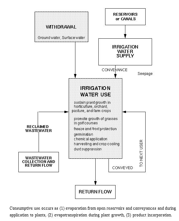
11.H.2. Sources of irrigation water-use information
Sources of irrigation water-use information are: (1) Agricultural
Extension agents, Universities, and Colleges of Agriculture, (2) the
U.S. Bureau of the Census, Agricultural Census and Farm and Ranch
Survey; (3) Federal or State Crop Reporting Service; (4) Department of
Agriculture, National Resource Conservation Service (NRCS); (5)
Irrigation equipment dealers; (6) State agency permitting or
allocating the withdrawal of water resources; and (7) U.S. Bureau of
Reclamation. 11.H.3. Measurement, estimation, and data-collection methods for
irrigation water use
Measurement of irrigation water use consists primarily of measuring
surface-water withdrawals from rivers, lakes, and streams;
ground-water withdrawals; and diversions and conveyance losses in
surface-water-delivery systems. However, determining irrigation water
use over large areas, which may include hundreds or thousands of
irrigation systems, requires reliance on data from other sources, or
developing methods to derive irrigation water-use values from
coefficients related to power consumption, or estimating water use
through irrigated acreage and crop consumption coefficients.
Irrigation consumptive use and ground-water return flow usually are
estimated.
11.H.3.a. Primary data acquisition
Measurements of irrigation water use focus on determining withdrawals
from surface and ground water, deliveries from surface-water-delivery
systems, conveyance losses through the surface-water delivery systems
(evaporation and seepage), and return flow through ground water and
surface water. Consumptive use during application and use of water by
the plants usually are estimated. It's important to determine which
water-use processes are critical to the objectives of the study
particularly where surface-water-delivery systems are used.
Withdrawals may be considered to have occurred when the water leaves a
reservoir, with delivery occurring when water is diverted from the
canal into the irrigation field. Conveyance losses (evaporation and
canal seepage), as opposed to the volume of water applied to the
field, can be a major component of the withdrawals, especially in arid
areas and areas with low water tables and porous surficial material.
In other areas, surface-water withdrawals may be considered to occur
as the water is diverted from the canals adjacent to the fields so
that conveyance losses are negligible. Similarly, withdrawals can be
from rivers, streams, or wells adjacent to the irrigation field with
negligible conveyance loss. To avoid confusion in this section,
diversions from natural surface-water bodies and aquifers are
considered withdrawals and diversions from canals are considered
deliveries to the field. 11.H.3.b. Secondary data acquisition
States that have allocation permits may have a reliable data base on
irrigation withdrawals. Data reported to these agencies needs to be
carefully examined to evaluate the reliability of the method used to
determine the reported withdrawals. Some withdrawals may be metered,
but frequently are estimated from pumping rates and measurement or
recollection of pump time duration, or may even reflect permitted
volumes. Estimates made from pumping rates may be too high if the
pumping rate used is the design pumping rate and not a measure of the
current rate. 11.H.3.c. Derived data
For large areas and for areas where measurements cannot be made,
irrigation withdrawals can be estimated from coefficients that relate
(1) irrigated acreage to water applied or (2) power used to pump
ground water to ground-water withdrawals. Land-use mapping and remote
sensing may be used to determine irrigated acreage with statistical
sampling used to develop coefficients for application rate and power
consumption. An approach can be developed that is tailored to meet
the objectives of the study and available data after review of
information on local cultivation and irrigation practices, crop types,
farm sizes and numbers, types of irrigation systems being used, local
geography, and water-supply sources.
Theoretical CU requirement (plant ET and PI) - precipitation = crop
irrigation requirement. (3)
where CU is consumptive use, ET is evapotranspiration, PI is product
incorporation, AL is application losses, and RF is return flow. 11.H.3.d. Quality assurance
As in quality assurance procedures for other uses, irrigation quality
assurance depends on using corroborative data. Reliable estimates of
irrigation water use depends on (1) a thorough understanding of all
the water-use processes involved, (2) use of corroborative data on
irrigated acreage, and (3) incorporating all the water-use processes
in a water balance equation, as in Equations 3, 4, and 5, in the
previous section. 11.D.4. Irrigation selected references
These references are supplemental to the ones in the General reference
Section.
Ahmed, J. and van Bavel, C.H.M., 1976, Optimization of crop irrigation
strategy under a stochastic weather regime: a simulation study: Water
Resources Research, v. 12, no. 6, p. 1241-1247.