Circular 1242
Contents
| Abbreviations | 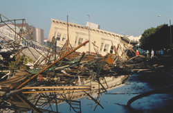 |
| 1. Executive Summary | |
| 2. Purpose |
|
| 3. Background | |
| 4. NEHRP Post-Earthquake Coordination Plan | |
| 4.1 Domestic Earthquakes | |
| 4.1.1 Phase I | 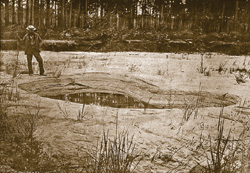 |
| 4.1.1.1 Incident Report and Plan Implementation (USGS) | |
| 4.1.1.2 Web Site Management (USGS) | |
| 4.1.1.3 Technical Clearinghouse (USGS, FEMA, EERI) | |
| 4.1.1.4 NEHRP Investigations Coordinator (USGS) | |
| 4.1.1.5 National Construction Safety Team Act (NIST) | 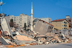 |
| 4.1.2 Phase II | |
| 4.1.2.1 Phase II Meeting (Investigations Coordinator) | |
| 4.1.2.2 Budget Supplemental Decision (FEMA, NIST, NSF, USGS) | |
| 4.1.3 Phase III | |
| 4.1.3.1 Workshop for Setting Investigation Priorities (NSF, USGS, FEMA, NIST) | |
| 4.1.3.2 Information Dissemination (USGS, NSF, FEMA, NIST) | 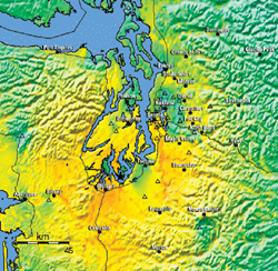 |
| 4.2 Foreign earthquakes | |
| 5. Recommendations for Further Action | |
| 5.1 Recommendation 1—Broaden Coverage and Comprehensiveness of Investigations of Earthquake Impacts | |
| 5.2 Recommendation 2—Encourage Use of Information Technology | |
| 5.3 Recommendation 3—Formalize Data Management and Archiving | |
| 5.4 Recommendation 4—Funding to Support Post-Earthquake Investigations | 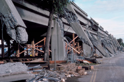 |
| 6. Annual Review of Plan | |
| References | |
1. Activities timeline for NEHRP Post-Earthquake Coordination Plan—Domestic
earthquakes
2. Investigators meet at technical clearinghouse to discuss findings from field
investigation of 2001 Nisqually, Washington, earthquake
3. Activities timeline for EERI post-earthquake activities—Foreign earthquakes
Collapsed building, Marina District, San Francisco California, 1989 Loma Prieta
earthquake (Photograph by C.E. Meyer, USGS)
Crater formed by liquefaction near Ten Mile Hill, South Carolina, 1886 Charleston
earthquake (Photograph credit: USGS 9th Annual Report, plate XX)
Damaged buildings in Korfez, Turkey, 1999 Kocaeli earthquake (Photograph by
C. Mueller, USGS)
USGS rapid instrumental intensity map of 2001 Nisqually, Washington, earthquake
(http://quake.usgs.gov/shakemap)
Cypress Viaduct collapse, Oakland, California, 1989 Loma Prieta earthquake.
(Photograph by H.G. Wilshire, USGS)

![]() U.S. Department of the Interior |
U.S. Geological Survey
U.S. Department of the Interior |
U.S. Geological Survey
URL:
Page Contact Information:
Page Last Modified:
