 Abstract Abstract
Mosca Pass Trail takes the hiker on a journey into the Earth’s crust. Here you can see the results of tremendous tectonic forces that bend and tear rocks apart and raise mountain ranges.
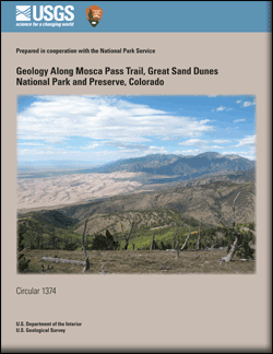
The trail begins near the Sangre de Cristo fault, which separates the Sangre de Cristo Range from the San Luis Valley. The valley is part of the Rio Grande rift, a series of fault basins extending from southern New Mexico to central Colorado, wherein the Earth’s crust has been pulled apart during the last 30 million years. Thousands of feet of sediment, brought by streams mostly from the Sangre de Cristo Range, fill the San Luis Valley beneath the Great Sand Dunes.
The trail ends at Mosca Pass overlooking Huerfano Park. The park is part of the larger Raton Basin, formed by compression of the Earth’s crust during the Laramide orogeny, which occurred 70–40 million years ago. Massive highlands, the remnants of which are preserved in the Sangre de Cristo Range, were uplifted and pushed over the western side of the Raton Basin. Streams eroded the highland as it rose and filled the Raton Basin with sediment. After the sediment was compacted and cemented to form sedimentary rock, the Huerfano River and other streams began to excavate the basin. Over an unknown but long timespan that probably lasted millions of years, relatively soft sedimentary rocks were removed by the river to form the valley we call “Huerfano Park.”
Between the ends of the trail, the hiker walks through an erosional “window,” or opening, into red sedimentary rocks overridden by gneiss, a metamorphic rock, during the Laramide orogeny. This window gives the hiker a glimpse into the Laramide highland of 70–40 million years ago that preceded the present-day Sangre de Cristo Range. The window is the focus of this trail guide. At the east end of the trail, near Mosca Pass, another trail follows the ridgeline south to Carbonate Mountain. Immediately after reaching the first summit above tree line, this trail crosses a narrow valley where red rocks mark an extension of the window across the range. Stunning vistas of the Sangre de Cristo Range extend north to the horizon. The uplifted range stands in sharp contrast to the San Luis Valley on the west and Huerfano Park on the east.
|
First posted July 3, 2012
Part or all of this report is presented in Portable Document Format (PDF); the latest version of Adobe Reader or similar software is required to view it. Download the latest version of Adobe Reader, free of charge. |

