Throughout the United States increasing demands for safe drinking water and requirements to maintain healthy ecosystems are leading policy makers to ask complex social and scientific questions about how to assess and manage our water resources. This challenge becomes particularly difficult as policy and management objectives require scientific assessments of the potential for ground-water resources to become contaminated from anthropogenic, as well as natural sources of contamination. Assessments of the vulnerability of ground water to contamination range in scope and complexity from simple, qualitative, and relatively inexpensive approaches to rigorous, quantitative, and costly assessments. Tradeoffs must be carefully considered among the competing influences of the cost of an assessment, the scientific defensibility, and the amount of acceptable uncertainty in meeting the objectives of the water-resource decision maker.
The Safe Drinking Water Act as amended in 1996 began a new era of prevention of drinking-water contamination and emphasized the importance of source-water management. The U.S. Environmental Protection Agency (USEPA) source-water assessment program, which has arisen from the Act, requires States to "assess water systems' susceptibility to contamination" (U.S. Environmental Protection Agency, 1997). Viewed as a first step in a 'multiple barrier' approach to protect drinking water, source-water assessments should consider the potential for contamination of ground-water resources and often incorporate existing wellhead protection programs. The need for ground-water vulnerability assessments is found in many other Federal, State, and local water-management programs, including the identification and location of sustainable sources of drinking water, ground-water disinfection, State pesticide management plans, underground injection of waste, and confined animal feeding operations. A National Research Council (1993) publication summarizes the broad array of definitions and approaches that are used by government as well as private and academic organizations in assessing the vulnerability of ground water to contamination. Based on specific objectives and resources available, assessments can be scoped to include individual wells or entire aquifer systems and target one contaminant, a group of similar contaminants, or contamination in general. The differences in the effectiveness of individual assessments will be linked to the degree to which the important physical/chemical processes for each particular situation have been identified and accounted for, uncertainty is addressed, and the original science and management objectives are appropriately met.
This report provides an overview of some of the common approaches used to scientifically determine the important factors controlling the vulnerability of ground-water resources to contamination. In addition, the report discusses the strengths and weaknesses of the various approaches as sources of scientifically defensible information for the water-resource management decision-making process. Descriptions of scientifically defensible methods are supported by example studies that have been conducted by the U. S. Geological Survey (USGS) often in cooperation with local, state, and regional water-resources agencies.
Two hypothetical examples of ground-water vulnerability assessments are used to define differences between management and science objectives and to highlight the process towards scientifically defensible water-resource management decision making. In this way, the report recognizes the broad array of appropriate methodologies that maintain objectivity, are scientifically defensible, and meet science objectives. These examples provide the background to show how successful ground-water vulnerability assessments blend scientifically defensible analyses with additional interpretations by water-resource decision makers in order to meet management and policy objectives.
The intended audience for this report includes experienced land- and water-resource managers, regulators, and policy makers (hereafter collectively referred to as water-resource decision makers) who must use vulnerability assessments in their work, as well as managers of scientific agencies (including the USGS) who are responsible for the design and promotion of investigations to scientifically determine the important factors controlling the vulnerability of ground-water systems to contamination. This report also may be useful as a primer to understand the science required by water-resource decision makers to assess ground-water vulnerability. For more detailed information on the scientific aspects of ground-water vulnerability assessments, examples of various approaches, and guidance, the reader is referred to the National Research Council (1993), Alley (1993), Barbash and Resek (1996), Nolan (1998), the U.S. Environmental Protection Agency (1997), the American Society for Testing and Materials (2000), or any of the case studies presented or cited in this report.
|
What is scientifically defensible? The scientific method can be defined as principles and procedures for the systematic and objective pursuit of knowledge involving the recognition and formulation of a problem, the collection of data through observation and experiment, and the formulation and testing of hypotheses. The scientific method therefore requires the objective use of facts without distortion by subjective feelings or prejudices. A scientifically defensible ground-water vulnerability assessment is one that follows the scientific method and includes adequate documentation of data, observations, and method of investigation to allow for independently reproducible results. |
Ground water occurs almost everywhere beneath the land surface. The widespread occurrence of potable ground water and the natural processes that tend to provide barriers to some types of contamination are some of the reasons why ground water is used as a source of water supply by about one-half the population of the United States, including almost all of the population that is served by domestic water-supply systems (Alley and others, 1999).
The ground-water-flow system, as defined in this report, includes effects of geologic deposits, interactions with surface waters, pumping, and other stresses on movement of water controlling advective transport of contaminants. Understanding the ground-water-flow system enables scientists to determine the potentially important factors controlling the intrinsic susceptibility of a ground-water resource. For this report, a ground-water resource is considered to be any aquifer or portion of an aquifer (including a well or wells) regardless of whether it is presently used a source of public water supply. In this way, the actual or potential source water for a public supply and(or) a public-supply well is included in the definition of a ground-water resource, as is any ground water that is not presently used by humans.
The geochemical system, as defined in this report, refers to all physical and chemical factors controlling the source, transport, and fate of natural and anthropogenic contaminants in a ground-water resource. Understanding the natural hydrogeologic and geochemical processes as well as the associated anthropogenic effects on a ground-water resource is required for complete scientific understanding of ground-water vulnerability.
Ground-water vulnerability to contamination was defined by the National Research Council (1993) as "the tendency or likelihood for contaminants to reach a specified position in the ground-water system after introduction at some location above the uppermost aquifer." The National Research Council (1993) refined the definition based on whether the assessment was contaminant specific, defined as "specific vulnerability," or for any contamination in general, "intrinsic vulnerability." The National Research Council definition includes the phrases "a specified position in the ground-water system," and "the uppermost aquifer" in recognition of the complexities of various hydrogeologic settings in relation to used resources and the possibility that the assessment could include an entire aquifer, a portion of an aquifer system, or end at the wellhead. Other relevant definitions are more specific and have separated aquifer characteristics from the broader case of aquifer or water-supply vulnerability to specific contaminants. In this sense, "aquifer sensitivity" or "intrinsic susceptibility" is a measure of the ease with which water enters and moves through an aquifer; it is a characteristic of the aquifer and overlying material and hydrologic conditions, and is independent of the chemical characteristics of the contaminant and its sources. An analogous definition to "aquifer sensitivity" is "intrinsic vulnerability" (Rao and Alley, 1993) defined by the time of travel of water from the point of contaminant entry to the reference location in the ground-water system. Vowinkel and others (1996) defined vulnerability as sensitivity plus intensity, where 'intensity' is a measure of the source of contamination. Clearly, ground-water vulnerability is a function not only of the properties of the ground-water-flow system (intrinsic susceptibility) but also of the proximity of contaminant sources, characteristics of the contaminant, and other factors that could potentially increase loads of specified contaminants to the aquifer and(or) their eventual delivery to a ground-water resource.
|
Intrinsic susceptibility and vulnerability of ground water. The intrinsic susceptibility of a ground-water system depends on the aquifer properties (hydraulic conductivity, porosity, hydraulic gradients) and the associated sources of water and stresses for the system (recharge, interactions with surface water, travel through the unsaturated zone, and well discharge). In this way, intrinsic susceptibility assessments do not target specific natural or anthropogenic sources of contamination but instead consider only the physical factors affecting the flow of water to, and through, the ground-water resource. The vulnerability of a ground-water resource to contamination depends on intrinsic susceptibility as well as the locations and types of sources of naturally occurring and anthropogenic contamination, relative locations of wells, and the fate and transport of the contaminant(s). Water-resource decision makers are often faced with a choice of deciding whether to manage a resource based on knowledge of intrinsic susceptibility or to target more comprehensive and contaminant-specific assessments of vulnerability. |
The vulnerability of a ground-water resource to contamination depends on intrinsic susceptibility as well as the locations and types of sources of naturally occurring and anthropogenic contamination, relative locations of wells, and the fate and transport of the contaminant(s). Water-resource decision makers are often faced with a choice of deciding whether to manage a resource based on knowledge of intrinsic susceptibility or to target more comprehensive and contaminant-specific assessments of vulnerability.
To understand the flow of water to, and through, a ground-water resource one must take into account all physical factors controlling sources of water and water movement. Therefore, it is necessary to understand the principles that govern ground-water movement and, ultimately, the advective transport of potential contaminants.
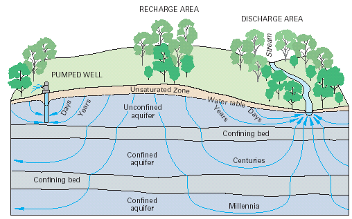
Under natural conditions, ground water moves in three dimensions along flow paths from areas of recharge to areas of discharge. Recharge occurs everywhere precipitation that falls on the land surface soaks into the ground, moves through the unsaturated zone, and enters the saturated parts of the subsurface. Recharge also can come from water in surface water bodies moving into the ground. Discharge from the saturated subsurface material occurs at springs, streams, lakes, wetlands, bays, the ocean in coastal areas, and as transpiration by plants whose roots extend to near the water table. The three-dimensional body of earth material saturated with moving ground water that extends from areas of recharge to areas of discharge is referred to as a ground-water-flow system (fig. 1).
|
| Figure 1. The areal extent and thickness of unconfined and confined aquifers, the length and traveltime of ground-water flow paths, and the thickness of the unsaturated zone vary locally as well as regionally. Figure modified from Heath (1983) and Winter and others (1998). |
The areal extent of ground-water-flow systems varies from a few square miles or less to tens of thousands of square miles. The length of ground-water-flow paths ranges from a few feet to tens, and sometimes hundreds of miles. A deep ground-water-flow system with long flow paths between areas of recharge and discharge may be overlain by, and in hydraulic connection with, several shallow, more local, flow systems (fig. 1).
The age (time since recharge) of ground water varies in different parts of ground-water-flow systems. The age of ground water increases steadily along a particular flow path through the ground-water-flow system from an area of recharge to an area of discharge. In shallow flow systems, ages of ground water in areas of discharge can vary from less than a day to hundreds of years; and ground water in areas of recharge are younger than discharge areas. In deep, regional flow systems with long flow paths (tens of miles), ages of ground water may reach thousands or tens of thousands of years (fig. 1). Shallower and younger ground water tends to be more susceptible to current sources of contamination from land surface. Deeper and older ground water tends to be in contact with naturally occurring contaminants for long periods of time. Understanding the direction and rate of ground-water movement in a ground-water system enables a better understanding and definition of where and why a system is intrinsically susceptible.
Almost any information on the ground-water system of interest will improve the ability to determine the intrinsic susceptibility of the ground-water system to contamination. Of particular use, however, is information that directly relates to the movement of ground water through the system. Aquifer material can be composed of unconsolidated (e.g. sands and gravels) and(or) consolidated geologic material (e.g. granites or limestones; commonly called 'bedrock aquifers'). In either case ground water flows through the void spaces or pores in the aquifer material. Two major factors control ground-water movement in a porous media; factors that define the movement of water within the porous media, and factors that define the movement of water along the boundary of the porous media where water enters or leaves the ground-water system.
Darcy's Law, which describes the flow of ground water within a porous media, defines the volumetric flow of ground water to be directly proportional to the hydraulic gradient and the hydraulic conductivity. The hydraulic conductivity is a property of the porous media and the fluid that represents the ability of the geologic framework to transmit water. The higher the hydraulic conductivity of a porous media, the easier it is for water to flow through it. The hydraulic gradient (i) is the change in head per unit of distance in a given direction.
The average linear velocity is defined as the average velocity of ground water flowing through the pore spaces of a ground-water-flow system. Darcy's Law and considerations of the effective porosity are used to calculate the average linear velocity:
| v = | ( Ki) / ne , eq. 1 |
| where: | |
| v | is the average linear velocity (L/T), |
| K | is the hydraulic conductivity (L/T), |
| Vt | is the total volume
of voids and aquifer material (L3). |
| i |
is the hydraulic gradient (difference
in hydraulic head / distance) (dimensionless), and |
| ne | is the effective porosity (dimensionless). |
The porosity (sometimes called the 'primary porosity') is a function only of the rocks or sediment of the aquifer, which may or may not be available for flow of ground water.
| n = | Vv / Vt , eq. 2 |
| where: | |
| n | is the porosity, |
| Vv | is the volume of voids (L3), |
| Vt | is the total volume of voids
and aquifer material (L3). |
The effective porosity is a function of the interconnectedness of the pore spaces, fractures, or other structures and can be similarly defined:
| ne = | Vvi/Vt , eq. 3 |
| where: | |
| ne | is the effective porosity
of the aquifer (dimensionless), |
| Vvi | is the volume of interconnected voids that are available for fluid transmission(L3), |
| Vt | is the total volume of voids and aquifer material (L3). |
The hydraulic conductivity, effective porosity, and hydraulic gradient are all, therefore, important in determining the volumes and rates of movement of ground water. Hydraulic head is usually measured as water levels in wells. Considerations of the three-dimensional aspects of flow and hydraulic properties require data from wells nested at different depths within an aquifer at a given location. Nested wells are used to measure the amount and direction of ground-water flow in a vertical direction below land surface. The spatial distribution of water levels can be mapped in two-dimensions to depict the potentiometric surface of the aquifer, which in turn shows the direction and rate of flow as limited by the hydraulic conductivity and the two-dimensional representation. Often scientists are able to simplify many ground-water-flow analyses to one or two dominant directions of flow, however, the assumptions necessary for these simplifications must be documented and interpretations must be made within the limitations of those assumptions.
Although the concepts and equations of flow in porous media commonly are used for ground-water flow through unconsolidated aquifers, special considerations are necessary for flow through consolidated aquifers (where the majority of fluids moves through fractures, joints, or other secondary porosity features). For example, the density of fractures in an aquifer or portion of an aquifer is not always an indicator of the best water producing intervals in the rock. Borehole geophysical techniques have been used to show that zones with the highest density of fractures did not necessarily correspond to zones with the highest hydraulic conductivity (Allen Shapiro, U.S. Geological Survey, written comm., 2001). Fractures that produce large volumes of water will depend on the hydraulic conductivity of the fractures, their interconnectivity with other fractures of high hydraulic conductivity, and the proximity to formations or portions of formations with large pore spaces. Fractures in most (but not all) formations account for relatively small porosities (pores constitute only a small volume of the formation) even though they may account for the majority of the volumetric flow rate. Furthermore, hydraulic properties of fractures in consolidated aquifers can differ by many orders of magnitude over the length of boreholes (Shapiro and Hsieh, 1998). It follows that the common practice of assigning a 'representative' hydraulic conductivity or porosity without prior knowledge of the interconnectivity and associated hydraulic conductivity of fractures in a consolidated aquifer will contribute to uncertainties in the assessment.
|
Ground-water flow through fractured rock. Much progress has been made in the development of techniques to characterize flow through fractured rock, however, the techniques tend to be costly and not typically incorporated in most ground-water vulnerability assessments. Recently, however, conceptual similarities found in the distribution of hydraulic properties in fractured-rock aquifers in similar geologic settings suggest transfer value can be provided from one site to the next (Allen Shapiro, U.S. Geological Survey, written comm., 2001). As models and conceptualizations are developed for different hydrogeologic settings in fractured rock aquifers, new understandings and approaches will become available to assess ground-water vulnerability for these complex systems. A thorough appreciation of the limitations in new, as well as conventional approaches that include simplifying assumptions of flow through fractured rock is a crucial component of any application of a ground-water vulnerability assessment. |
Other important factors that define the ground-water-flow system are the sources of water (inputs) to the ground-water resource and the stresses (outputs, including pumping wells) on the system. The external boundaries of the ground-water system, such as streams and recharge areas, affect the paths of water movement and the hydraulic head distribution (Reilly, 2001). The location of wells and rates of pumping also impact where water moves within the ground-water system. Therefore, a ground-water-flow system cannot be accurately understood until spatial and temporal aspects of all flows including inputs and outputs (from natural as well as human influences) are assessed.
The transport of contaminants through ground-water systems is associated with the path taken by the water, the length of time the contaminant takes along the path, and the chemical transformations that occur along the path. An accurate understanding of the potential for advective transport (transport of contaminants due only to the flow of the water) in and through a ground-water resource requires a thorough depiction of the hydrogeologic framework and is an ultimate goal of assessments of intrinsic susceptibility. The path taken by ground water as it transports contaminants through an aquifer is controlled by the ground-water-flow system. The hydraulic conductivity distribution will cause water to flow preferentially in parts of the system with high hydraulic conductivity and to move slower through or around parts of the system with low hydraulic conductivity. The paths taken as ground water moves from sources of contamination to other parts of the system will define the direction and rate of advective transport. Conservative environmental tracers can be used to determine the age of ground water, which is an indication of the rate of advective transport of contaminants. As water flows from the recharge boundary of the ground-water system (which can be a source of surficial contamination), the time it takes for water to reach different parts of the system or to reach wells is an indication of the ability of the ground-water system to advectivally transport contaminants.
|
Contributing areas. The area contributing recharge to a discharging well (fig. 2) is the area at the water table (or top boundary) where water entering the ground-water-flow system will eventually be removed by the well. The contributing area is a function of the interaction of natural sources and sinks with changes in the flow system due to pumping the well. Note that the contributing area, while in proximity to the well, may or may not be contiguous with the well (fig. 2), pumping can reverse flow directions causing natural discharge areas to become sources of recharge (fig. 3), and the contributing area can change as stresses on the resource change. |
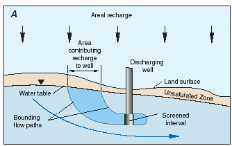 |
Figure 2. Cross-sectional (A) and map (B) views of the area contributing recharge to a discharging well in a simplified hypothetical ground-water system. The contributing area is a function of the interaction of natural sources and sinks with changes in the flow system due to pumping the well. Note that the contributing area, while in proximity to the well, may or may not be contiguous with the well. Figure modified from Franke and others, (1998). |
 |
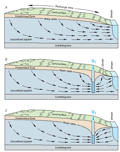 |
| Figure 3. The contributing area to a well can change as stresses on the resource change. Pumping a well can reverse flow directions causing natural discharge areas to become sources of recharge to the well. Figure modified from Heath (1983) and Winter and others (1998). |
Assessments of sources and sinks of water determine where water (and potential contaminants) enters the ground-water-flow system and where it may eventually leave the system. The most common of source of water to ground-water systems is recharge from precipitation. With areal recharge, as illustrated in figure 1, water flows from the water table (where recharge enters the ground-water system for an unconfined aquifer and includes recharge areas associated with outcrops of confined aquifers) and flows through the system to the discharge area (which is a stream in figure 1). The location where recharge enters the system and the rate of recharge are important controls on the quality of water that will ultimately discharge from supply wells.
Surface-water features such as streams and lakes can be either sources of water entering the ground-water system (recharge area) or sinks for water leaving the ground-water system (discharge area). Because surface water also can be a source of recharge (and potential contamination), understanding the interactions of surface water and ground water is part of understanding the entire ground-water-flow system and vital to determining the intrinsic susceptibility of a ground-water resource.
As water (and potential contaminants) migrate from sources at land surface, it first moves through an unsaturated zone before recharging the saturated ground-water system (fig. 1). As water moves through the unsaturated zone, physical and chemical processes occur that can affect the volume and rate of movement of the water (and potential contaminants). Aquifers associated with thick unsaturated zones (deep water tables) tend to have less, and slower moving, recharge than aquifers with thinner unsaturated zones.
The addition of contaminant-specific information to an assessment of intrinsic susceptibility is required in order to develop a complete ground-water-vulnerability assessment. General use of the word "contaminant" in this report can include any natural or anthropogenic chemical or physical property of the ground-water resource in question that is not desirable from a health or other perspective such as interference with water-treatment practices. Potential anthropogenic influences on contaminant sources, fate, and transport must be considered with the natural inherent interconnection of the geochemical system and the ground-water-flow system (Back and others, 1993). For example, a water resource can become more vulnerable to a naturally occurring contaminant if land-use practices affect the ground-water-flow system in such a way that enhances the solubility or mobility of the contaminant beyond the ambient geochemical conditions. Welch and others (2000) provide potential examples of anthropogenic practices that could increase arsenic concentrations in wells.
Contaminant-specific information includes: 1) information on the potential sources of contamination, 2) chemical properties for targeted contaminants or groups of contaminants, and 3) the role of important fate and transport mechanisms as a contaminant moves through the ground-water-flow system.
Understanding the spatial and temporal interactions of land use, the associated potential sources of contamination, and the intrinsic susceptibility of a ground-water resource are key to determining the geochemical system, and ultimately, the vulnerability of ground water to contamination. The potential sources of anthropogenic contamination usually exist along the boundary of the ground-water system with contaminants entering the ground-water system with recharge water. Sources of contamination such as poor well construction and underground point sources such as septic and storage tanks also can become significant issues on a local scale. In addition, the source area for a ground-water supply can change over time as stresses on the resource change (fig. 3-4). Natural sources of contamination depend on aquifer mineralogy and geochemical conditions, and can occur anywhere in an aquifer or water supply on local as well as regional spatial scales.
 |
Figure 4. Atrazine concentrations in shallow wells tapping an alluvial aquifer and at various distances from a nearby river. The concentrations of the contaminant in the aquifer are clearly related to concentrations in the river. Note the time lag in transport of atrazine contamination through the ground-water-flow system and associated attenuation of peak concentrations due to aquifer properties, chemical reactions, and dilution from surrounding ground water. Interactions with surface water can be a crucial component in the assessment of the intrinsic susceptibility and vulnerability of a ground-water resource. Figure modified from Duncan and others (1991). |
The source of contamination is usually classified in space as either a point source or a non-point source. A point source is a contaminant release at one specific location, whereas a non-point source is released over a widespread area. The source of contamination is also classified in time as either a continuous source or an instantaneous (one time) source. A continuous source is contamination that is released over a long period of time, whereas an instantaneous source is contamination that is released at only one time. The type of contamination source in space and time (that is, point source, non-point source, continuous source, instantaneous source) is important in determining the resulting spatial and temporal distribution of concentrations within a ground-water system. In some cases, the cumulative effects of point sources in proximity with each other can have similar characteristics to one or more non-point sources of contamination.
Contaminants can be transformed by geochemical, radiological, and microbiological processes as they are transported through various environments within the ground-water system. Some chemical transformations can change harmful contaminants into less harmful chemical species, while other processes can produce compounds that are more harmful to ecosystems or human health than the parent compound. The natural decay of some radionuclides can produce daughter products with different transport properties and health effects than the parent product (Focazio and others, 2000). In some cases, transformation products are found in the environment more often than parent compounds (Kolpin, and others, 1997). For example, ground-water remediation programs are increasingly focused on natural attenuation processes controlled by mixing, advection, and biodegradation as these processes serve to decrease concentrations and(or) viability of contaminants (Chapelle and others, 2000). Similarly, some chemical transformations can change relatively immobile compounds into highly mobile compounds, and change parent compounds to transformation products. Knowledge of the path and timing of ground-water movement as well as the chemistry and biology relevant for the contaminant present is important in determining the fate and transport of a contaminant and its associated transformation products. This is important for contaminants that rapidly change to other chemicals in the environment particularly when transformation or daughter products are more persistent than the parent compound. In addition, the vulnerability of a ground-water supply to many contaminants is dependent on the solubility and subsequent mobility of the contaminant as influenced by the specific mineralogy and associated geochemical conditions within the aquifer and pumped well. For example, naturally occurring arsenic can be tightly bound to aquifer materials in certain geochemical conditions but can be subsequently released to the pore waters of the aquifer if those conditions are changed, Welch and others, (2000). The chemical properties of a contaminant are important in the unsaturated zone as well as the aquifer itself. For example, some (hydrophobic) compounds strongly attach to soils in the unsaturated zone (as well as the saturated zone) before reaching the water table, and these compounds are attached until released by geochemical or other changes such as when the binding capacity of the soil is exceeded.
Diffusion and dispersion are among the important transport mechanisms that tend to spread contaminants as they move through the ground-water system. This spreading tends to lower contaminant concentrations in some parts of the system and increase concentrations in other parts beyond which would be realized by advection alone. Diffusion is the process by which both ionic and molecular species dissolved in water move from areas of higher concentration to areas of lower concentration. Dispersion is the process whereby solutes are mixed during advective transport due to velocity variations caused by flow variations within the pores and by heterogeneities in the hydraulic conductivity distribution (fig. 5). Dispersion usually causes more mixing than simple molecular diffusion.
 |
Figure 5. An instantaneous point source tends to spread out as the contaminant moves through the ground-water system. This is shown in the results of a tracer test conducted at Cape Cod, Massachusetts. A conservative tracer (one which does not decrease in concentration due to chemical reactions along a transport pathway) was introduced into the aquifer by three injection wells. As the plume of tracer moved down gradient with the ground water, the plume spread out due to dispersion. The dispersion caused the maximum concentration of bromide in the plume to decrease from 429 mg/L (milligrams per liter) at 33 days to 65.2 mg/L at 237 days to 39.0 mg/L at 401 days since injection. However, the area of the tracer in which bromide concentrations exceeded 1 mg/L tended to expand. If there were no dispersion, the injected tracer cloud would not have changed shape and concentration as it moved with the ground water. Thus, the effect of dispersion on the concentration of contaminants moving in a ground-water system can be important in determining the vulnerability of the aquifer to contamination. As the contaminant disperses, the maximum concentrations decrease and areas of the ground-water system that are not directly in the flow path can become contaminated as the plume spreads out. Figure modified from LeBlanc and others (1991). |
The methods described in this report can be divided into two major groups; subjective rating methods, and statistical and process-based methods. The first group produces categories of vulnerability or intrinsic susceptibility (usually high, medium, and low) and the second group does not. Most importantly, the first group produces final products (such as low to high categories) that are most appropriately developed by, and for, water-resource decision makers whereas the second group produces final products (such as delineations of contributing areas or probabilities of exceeding targeted concentrations) that are most appropriately developed by scientists for decision makers. In this way, results of the first group are closely tied to policy or management objectives whereas results associated with the second group are closely tied to science objectives and typically require additional interpretation on the part of decision makers.
Subjective rating methods focus on policy or management objectives and range from basic index methods to subjective hybrid methods. Relative degrees of ground-water vulnerability (or susceptibility) usually delineated as low, medium, and high are common endpoints for all subjective rating methods. This broad definition includes 'index' methods and some forms of 'hybrid' methods, and is distinct from the statistical and process-based methods highlighted in this report that do not include subjective vulnerability ratings.
Index methods (and closely associated "overlay methods") assign numerical scores or ratings directly to various physical attributes to develop a range of vulnerability categories. The index method is one of the most commonly used categorical rating methods and was among the earliest methods used (National Research Council, 1993). Overlay methods (National Research Council, 1993) will not be distinguished from index methods for the purposes of this report as they both combine maps of physical attributes by assigning scores that generally include subjective rankings of vulnerability.
The most widely used index method is DRASTIC, named for the seven factors considered in the method: Depth to water, net Recharge, Aquifer media, Soil media, Topography, Impact of vadose zone media, and hydraulic Conductivity of the aquifer (Aller and others, 1985, p. iv). The point rating system for DRASTIC was determined by the best professional judgment of the original method developers. The DRASTIC method has been used to produce maps in many parts of the United States (Durnford and others, 1990), and in Israel (Melloul and Collin, 1998), Nicaragua (Johansson and others, 1999), Portugal (Lobo-Ferreira and Oliveira, 1997), South Africa (Lynch and others, 1997), and South Korea (Kim and Hamm, 1999). The index method has been used to develop maps at a variety of scales, including national, (Kellogg and others, 1997; Lynch and others, 1994), statewide (Hamerlinck and Ameson, 1998; Seelig, 1994), and individual counties and townships (Regional Groundwater Center, 1995; Shukla and others, 2000). The index method is a popular approach to ground-water vulnerability assessments because it is relatively inexpensive, straightforward, and uses data that are commonly available or estimated, and produces an end product that is easily interpreted and incorporated into the decision-making process (fig. 6).
 |
Figure 6. Generally, the index method incorporates subjective judgment to assign a numerical index or score to pre-determined variables such as depth to ground water, land use, and soils which are then combined to produce a total rating of the ground-water vulnerability or susceptibility (fig. 6a). Note that the maps overlaid in figure 6a do not include any data that quantify contaminant concentrations or chemical properties, although in some cases surrogate indicators of contaminant source strength (e.g. land use/cover) or other contaminant characteristics can be included. The scoring system is used to provide a simple map of vulnerability categories subjectively categorized from low to high (fig. 6b). These categories, while easily incorporated into management and policy decision making, can be difficult to defend scientifically because of inherent subjectivity. |
 |
In this report, hybrid methods in general are defined as any methods that combine components of statistical, process-based, and(or) index methods. Objective hybrid methods include combinations of statistical, process-based, or other objective components in the determination of explanatory variables or processes. On the other hand, subjective hybrid methods, which also include combinations of statistical, process-based, or other objective components, incorporate subjective categorization and indexing of vulnerability. Subjective hybrid methods commonly do not rely on preconceived scoring systems such as DRASTIC or other index methods but instead produce project-specific categorizations.
Vowinkel and others (1996) used pesticide-use intensity near public-supply wells, distance of the wells from aquifer outcrop (recharge) areas, soil organic matter content, well construction data, and land use to develop a map showing wells with low, medium, and high ground-water vulnerability to pesticides across the State of New Jersey. They showed that pesticides were detected most frequently in one part of the study area (categorized as "the high vulnerability group") and not at all in other parts of the study area (categorized as "the low group"). Nolan and others (1997) produced a map for the 'risk' of nitrate contamination in ground water using nitrogen loading, population density, soil hydrologic group, and woodland to cropland ratio. A scoring system was developed by examining scatterplots and boxplots of nitrate concentrations for each of the four factors and determining where nitrate concentrations increased above an assumed background concentration of 2 mg/L. The scoring system was then tested for statistical significance by comparing nitrate concentrations in each of the score categories using Wilcoxon statistical tests. The final map showed 'aquifer vulnerability' to nitrate based on 'increasing risk' categories of low to high. Rupert (2001) used nonparametric statistical correlations between nitrate concentrations in ground water and depth to ground water, land use, and soil drainage to develop a hybrid approach (fig. 7). In addition, Rupert (2001) compared the map with an independent set of nitrate concentration data to further elucidate the strengths of the map.
 |
| Figure 7. Some hybrid methods incorporate objective
measurements of, for example, concentrations of targeted contaminants in
the calibration of a model. However, in order to provide end products that
are easily incorporated into water-resource decision making, subjective
categorizations of vulnerability remain part of the method. Figure modified
from Rupert (1998). |
Other examples of subjective hybrid methods include those that combine the index method with a process-based model such as a contaminant-leaching model. The results of the contaminant-leaching model (or other process-based model) are used to calculate a score that is combined with scores from other mapped data to produce a ground-water vulnerability category. For example, Morgan's (1998) hybrid method used PATRIOT, or "Pesticide Assessment Tool for Rating Investigations of Transport" (U.S. Environmental Protection Agency, 1994). PATRIOT uses the process-based PRZM, or "Pesticide Root-Zone Model" (U.S. Environmental Protection Agency, 1993b) to calculate indexes for each polygon in the study area by quantifying the leaching potential of a targeted pesticide.
Other methods focus on science objectives and range from statistical to deterministic or process-based approaches or hybrid approaches that do not produce subjective categorizations. These methods commonly require additional interpretation by the water-resource decision maker (in consultation with the scientists) in order to meet policy and management objectives, but ultimately help decision makers to scientifically defend their decisions because the scientist does not subjectively determine indexes of vulnerability.
Statistical methods range from simple summary or descriptive statistics of concentrations of targeted contaminants to more complex regression analyses that incorporate the effects of several predictor variables. Maps showing concentrations of targeted contaminants measured in wells are often useful preliminary depictions of the spatial extent of contamination or occurrence although the maps are limited to descriptive rather than diagnostic purposes. Additional information and data such as potential sources of contamination and factors affecting the intrinsic susceptibility of the resource are often included in more rigorous statistical analyses such as logistic regression which attempts to account for potential explanatory variables.
Simple descriptive statistics such as means, medians, and percentiles are often used to summarize the point locational information on these maps, which eventually can be useful for more detailed analyses such as exploring relations with geology. For example, Ryker (2001) plotted arsenic concentrations analyzed in water samples collected from approximately 31,000 wells across the United States, developed a national-scale point map of arsenic concentrations, and used simple descriptive statistics to summarize the data. This limited approach addresses only occurrence and distribution and would require additional analyses to assess vulnerability or processes controlling vulnerability. Welch and others (2000) took the national-scale point map of arsenic concentrations one step further and overlaid maps of geochemical significance to illustrate potential natural controls on arsenic occurrence and distribution nationally. Maps of concentration data can be statistically associated with other maps of potential explanatory variables to provide a more comprehensive depiction of important factors influencing vulnerability. A simple statistical summary such as this is often a crucial part of a more detailed assessment (below) or may be sufficient to meet objectives of some types of assessment needs. Other geostatistical mapping techniques such as kriging are not typically used for ground-water-vulnerability assessments though may have potential for some objectives.
When a dataset of water-quality and potential explanatory variables is available, statistical models in the form of regression equations can be used to predict probabilities of contamination. Hypothesis tests allow elimination of insignificant variables that offer little to the assessment process. The procedure produces weighting factors that optimize the use of important variables thereby removing the need for subjective influences of best professional judgment in determining the importance of each variable. Logistic regression is a statistical method that predicts a probability of occurrence (Helsel and Hirsch, 1992). For example, equation 4, or one similar, is developed, where the left side of the equation is a probability scaled between 0 and 1. Re-expressing the equation by taking the logarithm of the odds ratio, log [ p/(1-p) ] of each side results in equation 5, the right side of which looks like a standard regression equation:
p = Probability (event) eq.
4
= e (b0
+ b1 *var1 + b2 *var2 + …)
/ (1 + e (b0
+ b1 *var1 + b2 *var2 + …)).
log (p/(1-p)) = b0
+ b1*var1 + b2*var2 + …,
eq. 5
where
var1, var2, … are
independent variables, and
b0 , b1, … are statistically
derived coefficients.
Logistic regression analysis returns a hypothesis test for each independent variable that determines whether the variable explains a significant amount of the contamination probability. Variables that are statistically insignificant can be dropped. The remaining variables are weighted by their slope coefficients to produce the final estimates of probability.
To illustrate the method, Erwin and Tesoriero (1997) modeled the probability of finding nitrate concentrations greater than 3 mg/L in ground water of the Puget Sound region using several independent variables. Probabilities were significantly related to well depth, the type of surficial geology, and percents of urban and agricultural land use within a 2-mile radius of the well. In addition, this approach can reveal other statistical relations. For example, it was shown that the probability of elevated nitrate concentrations decrease with increasing well depth, and is higher in agricultural and urban basins with concentrations highest in coarse-grained glacial deposits as compared to the two other types of surficial geology. As with any statistical model, these relations while statistically significant do not represent causality. By computing the values for each independent variable across the entire region and entering these into the equation, the predicted probabilities can be mapped for the entire region (figure 8). Rupert (1998) completed two assessments using logistic regression for atrazine/deethylatrazine and nitrate, and was able to conclude that the difference in the two assessments could largely be attributed to differences in the chemical behavior of the compounds. Squillace and Moran (2000) assessed the probability of detecting MTBE in drinking water supplied by ground water. Maps created by Tesoriero and Voss (1997), Rupert (1998), and Squillace and others (1999) delineated probability areas representing the probability of detecting the contaminant(s) as opposed to subjective categories of vulnerability that are used with the more common index methods. Nolan and others (2002) created a national-scale logistic regression model to simulate the probability of nitrate contamination in recently recharged ground water. This analysis was used to develop a map of the conterminous United States showing the probability that nitrate concentration exceeds 4 mg/L (considered above natural background concentrations).
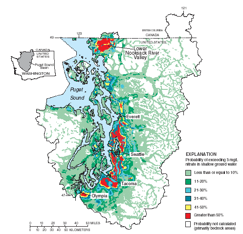 |
| Figure 8. Statistical methods such as logistic regression can use measured water-quality data and statistically significant independent variables (such as soil type, land use, and well depth) to objectively calculate the probability to exceed a targeted concentration (such as a Maximum Contaminant Level or other standard) in a study area. Figure modified from Erwin and Tesoriero (1997) |
Logistic regression equations can also be used to predict probabilities that more than one threshold is exceeded. Two regression equations, each with their own probabilities, can place a prediction into one of three categories, below the first threshold, between the first and second, and above the second threshold. For example, Mueller and others (1997) used basin characteristics and land-use information to predict the probabilities that nitrate concentrations in streams throughout the midwestern United States would exceed 3 and 10 mg/L. Predictive variables included the percent of corn grown in the basin as a surrogate for fertilizer applications throughout the area. Certainly, results of probabilistic methods, although quantifiable, must necessarily avoid erroneous interpretations near the 0 or 100 percent probability levels.
Predictions of the probability of contamination, or any other event, can be improved by using methods that produce estimates most closely matching measured data. Predictive statistical models, calibrated with measured data, can be compared to observed values for a separate set of observations not used in establishing the coefficients. This procedure will give a more complete picture of the reliability of predictions. A major strength of a statistical assessment method is its ability to use methods that mathematically assign empirical weights, thus allowing the possibility of eliminating statistically insignificant variables and highlighting those of most significance. In addition, modeling the probability that contamination occurs can result in an end product (map) showing statistically derived indications of vulnerability as opposed to the more subjective categorical rating methods. Statistical models produce coefficients that statistically best fit relations to observed data and thereby avoid the use of subjective ratings of vulnerability.
Process-based methods refer to approaches that either simulate or otherwise take into account physical processes of water movement and the associated fate and transport of contaminants in the environment. These approaches usually include the use of process-simulating models that calculate the distribution of vulnerable or intrinsically susceptible areas based on the movement of water and solutes. In this way, process-based methods can be purely based on deterministic models or can be a type of hybrid method that is based on physical and chemical laws, but incorporates statistical components such as regression equations to facilitate the simulation of complex hydrologic or chemical processes. The latter type of hybrid method is distinct from the subjective hybrid methods that include indexes, as shown in the previous section. As used in this report, process-based methods may be used to assess one or many underlying processes and can include direct field observations of environmental tracers placed in the context of a ground-water-flow system. Thus process-based methods include purely deterministic governing equations as well as other physically based techniques that are used to assess important underlying processes. In addition, process-based methods do not attempt to subjectively score processes or factors, and therefore, do not rate vulnerability categories. Instead, intrinsic susceptibility and vulnerability are typically represented by physically based ranges in model parameters or outputs.
Process simulating ground-water models are usually used in two different ways: 1) to determine the intrinsic susceptibility of an aquifer and, 2) to assess the vulnerability of ground-water supply to a targeted contaminant or contaminants. Process simulating models used to assess intrinsic susceptibility often focus on determination of the sources and(or) movement of water (including estimations of the age of water); whereas models used to assess vulnerability to a contaminant focus on the sources and(or) movement of the contaminant. In this way, process-simulating models typically account for one, or a few, important processes but do not typically account for all processes that control vulnerability. For example, Holtschlag and Luukkonen, (1997) used a process-based model to assess the potential for atrazine to leach to a water-table aquifer in Michigan, and thereby addressed an important component of aquifer vulnerability. Process-based assessments can be used to highlight the most important factors controlling vulnerability that ultimately help water-resource decision makers design targeted management practices.
The governing equation of ground-water flow incorporates Darcy's Law and the
Law of Conservation of Mass. In its basic form, the governing equation is a
three-dimensional time-dependent partial-differential equation that must be
solved numerically. With accurate boundary and initial conditions, inputs and
outputs, the equation can be used to model the interacting components of a complex
ground-water-flow system. Simplifying assumptions (for example, steady-state
or two-dimensional flow) are often used to decrease mathematical and assessment
complexity, and therefore, must be considered a potential source of uncertainty
and dealt with accordingly. MODFLOW (Harbaugh and others,
2000), a popular computer modeling code that solves the governing equations
of ground-water flow, is often used for quantitative modeling of ground-water
flow and assessment of intrinsic susceptibility. MODFLOW includes several process-based
modules to simulate the interactions of key interacting components of the ground-water-flow
system. In addition, recent advances in parameter estimation techniques (Hill
and others, 2000) provide opportunities to objectively analyze various combinations
of calibrated parameters in ground-water-flow models and assess uncertainty.
Masterson and Walter (2000) delineated the source
of water to a ground-water resource under current conditions for the different
discharge areas of western Cape Cod, Massachusetts, with a three-dimensional
ground-water-flow model in conjunction with particle tracking (Pollock,
1994) to determine flow patterns and assess intrinsic susceptibility. This
approach, although complex, accounts for many interacting processes controlling
intrinsic susceptibility and is not limited to one or a few key processes. Their
map (fig. 9) shows where water recharging western Cape Cod
will eventually discharge, including contributing areas to pumping wells. The
map is useful in the determination of the intrinsic susceptibility of the aquifer
as well as public supply wells and surface-water bodies to contamination by
advective transport of contaminants.
 |
| Figure 9. An appropriately calibrated ground-water-flow model can accurately and realistically account for the interaction of discharging wells with each other and simulate contributing areas to these wells that are consistent with the system-wide flow field. This process-based method can address effects of partially penetrating wells and the concern that a contributing area for any one well depends on the interactions with other processes (e.g. pumping and recharge) that occur over the entire system. For example, if the pumping rate of one well changes, it may affect the contributing area of another well that is maintaining a constant pumping rate. The additional analysis of ground-water particle tracking is a powerful tool to objectively assess advective transport processes and intrinsic susceptibility while accounting for the effects of discharging wells and other factors. Figure modified from Masterson and Walter (2000). |
Other models and approaches to comprehensive assessment of interacting factors controlling intrinsic susceptibility are discussed throughout this report. Process-simulating models that combine assessments of the sources and movement of water as well as contaminants are not commonly used in ground-water-vulnerability assessments but could ostensibly account for all important hydrologic processes controlling vulnerability.
|
Balancing objectivity, complexity, and accuracy under
conditions of uncertainty. Generally, process-based approaches are designed to provide the most accurate representations of interacting physical and chemical processes that control intrinsic susceptibility and ground-water vulnerability. However, process-based approaches can be quite complex, are typically limited in spatial scale, and sources of uncertainty are difficult to quantify. Statistical approaches provide useful tools to assess the relative roles of important independent variables or factors controlling vulnerability over various spatial scales, but cannot include all the deterministic components needed to address complex interacting processes of cause and effect. In addition, statistical methods tend to be simpler to use than process-based approaches and often provide quantitative measures of statistical uncertainty. Index methods tend to be the most simple to apply and can be used over a range of spatial scales, but include subjective categorizations with uncertainty that cannot be quantified. Properly designed hybrid methods that combine statistical and deterministic or process-based components and exclude subjective categorizations can provide insights on important processes controlling vulnerability over a range of spatial scales while maintaining objectivity and hence scientific defensibility. On the other hand, a subjective hybrid method that combines results of an objective model with a subjective categorization scheme to produce indexes of vulnerability would lose objectivity and ultimately may not be scientifically defensible (fig. 7). It is clear that no one approach is better than the rest for all situations (fig. 12); however, a fundamental characteristic common to all scientifically defensible ground-water-vulnerability assessments is that scientific approaches must remain accessible to the water-resource decision makers while not compromising the scientific method through use of subjective categorizations. |
In addition to the use of environmental tracers to aid in the calibration of ground-water models, environmental tracers can be used directly to determine the source of ground water or the age of ground water (fig. 10). The stable isotopes of hydrogen and oxygen can be used to differentiate the source of water within a ground-water system (Coplen and others, 1999). Tracer techniques used to date ground water, such as carbon-14, chlorofluorocarbon (CFC), or tritium/helium dating (Plummer and others, 1993), can be used to assess a key component of the intrinsic susceptibility of a resource to modern sources of anthropogenic contamination. In an ideal example, a ground-water resource that was recharged hundreds of years ago is not currently susceptible to modern sources of anthropogenic contamination if there is no mixing with modern waters. For similar reasons, a ground-water resource that is recharged in modern times is susceptible to modern sources of anthropogenic contamination. In this way, quantification of the age of ground water and the degree of mixing of waters of various ages must be carefully quantified in order to represent surrogate indicators of the rates of flow and the residence time of the ground-water resource and ultimately the intrinsic susceptibility to modern sources of anthropogenic contamination. Bohlke and Denver (1995) combined ground-water dating with chemical and isotopic analyses to assess the history and fate of nitrate contamination in Coastal Plain watersheds. This approach addresses the vulnerability of a water resource to a targeted contaminant (nitrate) by moving one step beyond the preliminary assessment of intrinsic susceptibility obtained with only age dating and environmental tracers. Seiler and others (1999b) showed that the presence of caffeine and pharmaceuticals in well water might be indicative of wastewater contamination in an aquifer. Shelton and others (2001) showed how the occurrence of low-level volatile organic compounds (VOCs) in public supply wells could be used as indicators of ground-water vulnerability. That study used VOCs as a tracer of postindustrial-aged ground water recharged after the onset of intense urban development in California. Snyder and others (1998) used a ground-water-flow model with particle tracking to evaluate the intrinsic susceptibility of an aquifer in Clark County, Washington. In their analysis, ground-water age estimates obtained from chlorofluorocarbon (CFC) analyses were also used to help calibrate the effective porosity in the model. This approach enabled investigators to show where ground water with ages less than the time since the industrialization of the Clark County area are most likely to be affected by anthropogenic sources of contamination.
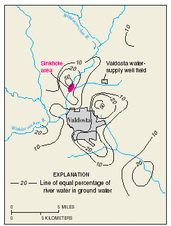 |
Figure 10. The Upper Floridan aquifer
near Valdosta, Georgia is hydraulically connected by sinkholes and other
conduits to flow in river channels. Contaminants in the surface water
can move rapidly through the ground-water system and contaminate water
supply wells. This is common in karst terrain and poses significant challenges
for process-based assessments of intrinsic susceptibility. Plummer and
others (1998) identified three basic sources
of water in the area; river water, young regional infiltration water,
and old regional water emphasizing the complexity of the flow system and
difficulties in assessing intrinsic susceptibility of the ground-water
resource. Using the oxygen-18 stable isotope and chloride concentrations,
the percentage of river water in the ground water was determined thereby
providing an objective quantitative assessment of an important component
of intrinsic susceptibility for the hydrologic conditions analyzed. Figure
modified from Plummer and others (1998). |
For many objectives requiring ground-water-vulnerability assessments, advective transport may be the most important transport mechanism; however, it is important to assess the relative roles of various transport mechanisms in the overall movement of a given contaminant because advection alone may not accurately portray important aspects of the transport pathways. For example, Reilly (1993) considered the relative effects of density-dependent solute-transport (including advection and dispersion) to analyze the upconing of salty water in a coastal well (fig. 11)
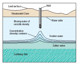 |
Figure 11. Whereas advective transport is a dominant control on the intrusion of saltwater into fresh water resources, it has been shown by many investigators that the differences in density between saltwater and freshwater and the effects of diffusion and dispersion can play an important role. In many cases, it may be reasonable to assume that non-advective processes are insignificant. However, the relative importance of non-advective transport processes and other physical, chemical, and biological factors that potentially control the concentrations of a given contaminant must be determined before deciding on the most appropriate approach to take for a ground-water-vulnerability assessment. Figure modified from Reilly (1993). |
Occam's razor is defined (Merriam-Webster, 1996) as "a philosophical or scientific principle according to which the best explanation of an event is the one that is the simplest, using the fewest assumptions or hypotheses." Accordingly, explanations of unknown phenomena should be sought first in terms of known quantities. As stated previously, approaches to ground-water-vulnerability assessments are determined by objectives and resources available with tradeoffs among scale, process, objectivity, and complexity. In considering these tradeoffs, a ground-water-vulnerability assessment must maintain impartiality and objectivity commensurate with a reproducible, scientifically defensible product that includes appropriate levels of complexity in the face of uncertainty.
Uncertainties in ground-water-vulnerability assessments are unavoidable and are derived from model or data-related errors (National Research Council, 1993). The challenge of meeting specific science objectives of ground-water-vulnerability assessments while minimizing uncertainty with limited resources requires careful considerations in design of the approach and realistic expectations of data and model performance.
Uncertainties in any scientific assessment are a result of inaccuracies or errors related to data or input parameters (or model coefficients) and other inaccuracies in models themselves or numerical procedures. These errors must be addressed for the results to remain scientifically defensible. Loague and others (1996) define the 'total' or 'simulation' error of a ground-water-vulnerability assessment to be the sum of model, data, and parameter errors. Uncertainties in model output can result from assumptions in the model itself, the wrong choice of models, the input data and numerical approximations.
Inappropriate use of water-quality data can contribute to inaccuracies in a ground-water vulnerability assessment. Water-quality conditions represented by a single water sample collected from a given well may or may not represent the same water-quality conditions sampled from the same well at another time and(or) another well even if the wells are in proximity. The distribution of chemical constituents in ground water varies horizontally, vertically, and temporally. Wells, which provide access for the collection of ground-water samples, can be constructed many different ways with various casing diameters and screen lengths (or open hole lengths) and with various construction material. Thus, ground-water samples collected from wells usually represent water that has been mixed to some degree with waters of various ages and source locations. The temporal and spatial variability of sources of contamination over all relevant time and space scales and the mixed age of a water sample collected from a well will add uncertainty to any analysis of water-quality data unless accounted for accurately. The effect and magnitude of these uncertainties on the analysis will depend upon how closely the construction of the wells, the flow paths of the ground water, and the timing of the introduction of contaminants are taken into account in the design of the study. Even in the best designed studies with specially constructed wells, there will be variability in the concentration of chemical constituents among the water samples due to the inherent spatial and temporal heterogeneity of ground-water systems. Therefore, many potential sources of uncertainty exist in water-quality data that are used to develop and test models of ground-water vulnerability. When using results of ground-water vulnerability studies based on statistical analyses, it is important to consider the amount of underlying variability in the water-quality conditions, which could cause inaccuracies in the results of the analysis.
|
Interpreting water-quality data in context with other
important The use of measured water-quality data, while crucial for some purposes such as development, calibration, and verification of statistical and process-based models, can actually obfuscate a ground-water-vulnerability assessment if spatial and temporal variability in water quality is significant and the relation to sources is not accounted for in the assessment. A simple example is when a contaminant is not detected in a given well even though a source is nearby. The lack of detection may be the result of the lag in time of transport of the contaminant from the source to the well, imprecise analytical methods, chemical transformations, or other causes and consequently may not be an accurate indication of vulnerability. |
In spite of the difficulties in obtaining the requisite data and interpretations
to assess uncertainty a limited number of ground-water-vulnerability assessments
have recently incorporated various types of uncertainty analysis. For example,
Starn and others (2000) analyzed uncertainty in delineations
of contributing areas to wells by comparing process-based contributing areas
with probabilistic contributing areas using a Monte Carlo approach. Other examples
include tests of statistical significance. For example, Tesoriero and Voss (1997),
and Rupert (1998) used hypothesis tests to determine
the statistical significance of various parameters in their assessments. Holtschlag
and Luukkonen (1997) analyzed uncertainties in an
assessment of atrazine leaching to ground water in Michigan. Through a series
of statistical techniques known as Monte Carlo simulations, Holtshlag and Luukonen
(1997) addressed simplifying assumptions in the leaching
model, uncertainties in hydrologic, lithologic, and pesticide characteristics,
and uncertainties in spatial interpolation. A thorough review of different approaches
to uncertainty analyses associated with ground-water vulnerability assessment
is beyond the scope of this report but can be found elsewhere (National
Research Council, 1993, Nolan, 1998).
Two hypothetical examples of approaches used to assess the important factors controlling ground-water vulnerability (regional and local in scope) with significantly different scopes and objectives are presented below. The two examples can be used to compare scientific considerations and major contributors to uncertainty inherent in some common approaches to ground-water-vulnerability assessments. Whereas the reader is encouraged to explore the range of mathematical uncertainty analyses available, those techniques will not be detailed in this report. Instead, the two examples are followed by a discussion of the potential contributions to uncertainty and additional approaches that are typically used to decrease and (or) elucidate uncertainty in order to provide scientifically defensible results.
|
Assessing statistical uncertainty. Statistical uncertainty deals with estimation of population characteristics from samples of data. Quantification of statistical uncertainty provides insight into limitations of using subsets of data to represent an entire population; however the quality of a statistical analysis is no better than the quality of the data used – it can be worse, but no better (Haan, 1977). In this sense, 'data' is used not only in the conventional sense of measurable quantities but also in this sense of simulations and, therefore, choice of model. Statistical uncertainty, although quantifiable, does not include quantification of measurement errors, data transmission errors, data processing errors, errors associated with choice of model, and other errors in interpretations. Therefore, although statistical approaches to ground-water-vulnerability assessments provide a means to quantify statistical uncertainty not available in process-based approaches, they do not provide any more insight to the other potential sources of error. |
Ways to reduce uncertainties and to maintain scientific credibility without excessive use of fiscal resources are too numerous and case specific to be detailed here; however, a comparison of approaches for two hypothetical examples presented here provides insight into: 1) the quantitative indications of statistical uncertainty associated with statistical approaches as applied to a regional-scale problem; and 2) the increases in understanding of the ground-water system gained with process-based approaches, which thereby decrease sources of uncertainty in the overall assessment of a local-scale problem. Each hypothetical example is presented with a water-resource management objective and a science objective.
|
Scientifically defensible water-resource management objectives
require successful completion of the associated science objectives. Water-resource management objectives are those required by water-resource managers, policy makers, and regulators in order to make decisions regarding management of the resource. Science objectives are associated with hypothesis tests or other reproducible, objective approaches that provide a sound basis for scientifically defensible decision making, and ultimately help meet the associated water-resource management objective. |
The first hypothetical example shows how quantitative information obtained from a statistical model is used to provide a measure of uncertainty in a regional-scale assessment by using measured water-quality data and statistical techniques that increase understandings of explanatory variables and their relative contributions to uncertainty. The second hypothetical example shows how increases in the quality and understanding of the major physical and chemical data and processes governing ground-water vulnerability can decrease uncertainty in the assessment.
Regional-scale mapping of ground-water resource vulnerability to a targeted contaminant.
Management Objective: Determine the impact* of a proposed new federal standard for contaminant X across a large region.
Science Objective: Determine the probability of exceeding targeted concentrations of contaminant X and determine the spatial patterns of the most important factors controlling ground-water vulnerability to contaminant X across a large region.
Approach: Develop a regional scale map delineating portions of aquifer areas with known, or potential for, contamination by X.
For simplicity, the following assumptions will be made (note that these assumptions should eventually be considered when addressing uncertainty in the assessment):
A common approach is the index method. The index method will produce a map with areas delineated based on indexes of ranges of vulnerability to contaminant X (fig 6.). As detailed in the section on subjective rating methods, the numerical index or score assigned to each factor and the relative weighting of scores between factors is based upon best professional judgment. For this hypothetical example, the depth to the water table, soil texture, and annual use of contaminant X have been determined by a panel of experts to be the most important factors in controlling the potential for the ground-water resource to become contaminated by X; relative indexes are assigned to a map of the region (fig. 6). In order to develop regional maps of the depth to the water table, soil properties, and annual use patterns of contaminant X, several sources of information and various state, county, and other, databases must be pieced together. No data on concentrations of contaminant X in the ground water are used in developing or comparing to the vulnerability index map. Relative categories such as low, medium, or high are then applied to the indexed areas for simplicity. These relative categories indicate that areas with a high ranking have a greater pre-disposition to ground-water contamination by X than areas of medium or low ranking.
The lack of concentration data for the contaminant, combinations of many databases with varying degrees of quality control, scale, and subjectivity in this approach are some major contributors to uncertainty in the overall assessment. The categories of high, medium, and low do not include any quantifiable information or statistical significance that can elucidate the uncertainties in, for example, the important processes causing the difference in one ranking compared to another. Although it is possible to meet the management objectives with this approach, the lack of data and understanding of uncertainties limit defensible decision making (quadrant IV; fig. 12). Consequently, the decision maker is faced with the task of determining how 'reasonably' the combination of depth to the water table, soil texture, and use patterns truly reflects the impact of the proposed rule in the indexed areas. Therefore, to the extent possible it is important to remove subjectivity from the assessment and to provide some quantifiable measure of the uncertainty or probability of actual contaminant occurrence in the categorized areas. Attempts to achieve this balance may not provide detailed information on physical and chemical processes but will provide objective measures of the performance of the assessment therefore, giving the decision maker crucial information that could be used in defense of the decisions.
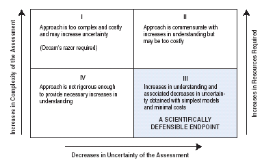 |
| Figure 12. Although attempts to increase understanding of ground-water systems tend to add complexity to a given approach, additional complexity in an approach does not necessarily equate to increases in understanding of the ground-water system or the ability to meet the associated objectives. The challenge in designing an objective scientific approach for a ground-water-vulnerability assessment is to find a reasonable balance among model (or assessment) complexity, resources required, and decreases in uncertainty gained while reaching predetermined science objectives (quadrant III). |
There are many different statistical approaches that can be used to minimize and(or) quantify uncertainty in meeting the science objectives. Three approaches are:
Local-scale process-based determination of the vulnerability of a public ground-water supply to a targeted contaminant.
Management objective: Determine where limited resources can be used most effectively to protect the local ground-water supplies from a specific contaminant 'X'. Also, determine where monitoring waivers and(or) reduced monitoring for contaminant 'X' is most reasonable.
Science objective: Determine contributing areas of targeted wells and identify potential sources of contaminant 'X' in those contributing areas (fig. 13 a and b).
Approach: Develop local-scale deterministic or process-based model or models in conjunction with ancillary data on contaminant sources and monitoring data.
For simplicity, the following assumptions are made (note that these assumptions should eventually be considered when addressing uncertainty in the assessment):
A common approach used is the fixed-radius method (U.S. Environmental Protection Agency, 1997). The fixed-radius method uses a simplified process-based approach to delineate an area (a circular area is used for simplicity but other shapes are possible) around a pumped well. The area is determined by the physically based premise that the time of travel of ground water through the aquifer to the well is a measure of the intrinsic susceptibility of the aquifer. When the limiting time of travel is based on characteristics of targeted contaminants (for example, 2-year time of travel based on presumed pathogen viability: U.S. Environmental Protection Agency, 1997) the assessment is extended from one addressing intrinsic susceptibility to one addressing vulnerability of the well to contamination.
A volume of water (Vw) equivalent to the amount pumped from the well in a given time period (often a 2-year time period is used for pathogens; though it is common to use various time periods and radii for assessments of general contamination) is calculated. This volume is converted to an equivalent cylindrical volume of water Vt and aquifer material using the well as the axis of the cylinder and the screened interval of the well (or thickness of the water bearing zone) as the height of the cylinder (h). The equivalent volume of water and aquifer material is calculated by dividing the pumped volume (Vw) by the porosity of the aquifer material (ne):
Vt = Vw / ne.
Therefore, the radius ( r ) is calculated by:
r = (Vt/(ph))1/2.
This method requires estimated or known values of the average pumping rate over the time period of interest, the thickness of the screened interval, and the porosity of the aquifer material (for this example all are assumed to be known with certainty). This is often the method of choice because where data on pumping rates and well construction are available, the calculation of the radius is limited only by the porosity, which can be obtained from published tables. As shown previously, porosity is the 'effective' porosity in consolidated, fractured rock aquifers. In practice, this method is often used in conjunction with other indicators of vulnerability such as water-quality monitoring and potentiometric-surface mapping as part of a more comprehensive effort, and is presented here for comparative and illustrative purposes.
The obvious major limitations in the radius method that result from a lack of understanding of the ground-water-flow system include: 1) the potential for an inaccurate representation of the contributing area and associated sources of water and contamination for the well, 2) the method generally is not applicable for many contaminants or important processes of contaminant transport, 3) no component of the assessment addresses uncertainty, and 4) the use of a circular or any other geometric shape is subjective. In the absence of consideration of the limitations and uncertainties, the radius method would appear to meet the science and management objectives because using a process-based approach, it results in clearly delineated areas associated with the public water system and therefore, would help to focus decision making where limited resources can be committed to protect the water supply. The radius method is also a relatively inexpensive approach. When including the limitations and uncertainties inherent in this approach however, it would likely fall into quadrant IV of fig. 12 because the decision maker is burdened with the responsibility of determining how scientifically defensible the delineated areas are without the benefit of any further understanding of the ground-water system or assessment of uncertainty.
The following example illustrates a step-by-step procedure to meet the science objectives that can reduce uncertainty in the overall assessment by increasing understanding of the important processes. Figure 13 depicts this procedure for hypothetical wells underlain by flow through an aquifer composed of unconsolidated sediments (note that different considerations can be required if the aquifer is composed of consolidated material). The step-by-step process-based approach that follows is one example that can be undertaken to increase understandings of the flow system and provide a more scientifically defensible product.
A step-by-step process-based approach is as follows:
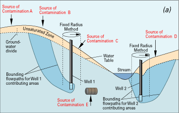 |
Figure 13. A hydrogeologic cross section through an unconfined (water-table) aquifer (a) and a cross section through an unconfined aquifer with an underlying confined aquifer (b). Both hypothetical cross sections contain public-supply wells with potential sources of contamination (A,B,C,D, and E). The commonly used fixed-radius method is applied to Wells 1 and 2 to delineate a subjectively chosen circular area representing the contributing area around each well. With sources of contaminants overlaid on the cross section (indicated by arrows), Well 1 is depicted as vulnerable to the source of contamination at C in the unconfined (a) as well as the confined (b) aquifers. Although this would meet the objectives of the assessment, the conclusions are erroneous because the actual contributing areas do not coincide with the fixed-radius method. In addition, important sources of uncertainty in the fixed-radius method are revealed because the method does not identify potential threats that could be caused by the potential sources of contamination at A, B, D, or E. For example, ‘D’ is clearly within the contributing area of Well 2. Consequently, an objective and accurate depiction of the contributing areas to Wells 1 and 2 is minimally required for a scientifically defensible assessment with reduced uncertainty. |
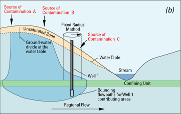 |
|
Chemical processes in the unsaturated zone. Deterministic or physically based modeling of contaminant transport through the unsaturated zone based on the governing equations of unsaturated flow is typically not included in ground-water vulnerability assessments (Barbash and Resek, 1996). However, physically based simulation could provide crucial insights into one of the most important components of the transport pathway for many contaminants, and hence ground-water vulnerability, particularly for those contaminants that are impeded or transformed in the soil. |
Quantitative estimates and(or) other indications of uncertainty can be incorporated in process-based and statistical approaches. It is common, and often beneficial, to methodically phase in components of a ground-water-vulnerability assessment over time regardless of the approach. In this way, one can constantly re-evaluate the balance among increases in understandings of the system and resources needed (fig. 12) in meeting the science objectives while accounting for sources of uncertainty. For process-based approaches, the steps provide additional insights on targeted processes; for example, a rudimentary understanding of the potentiometric surface can lead to changes in design of a conceptual model of the flow system that will, in turn, be used to develop a deterministic mathematical model of ground-water flow. Certainly, additional detailed work such as development of solute transport models can incorporate the properties of the contaminant identified above and be designed for the unsaturated and(or) the saturated zones. As with any mathematical model that requires large amounts of data and careful interpretations of results, it is important to avoid undue complexity not commensurate with the objectives of the assessment (quadrant I; fig. 12). On the other hand, too many simplifying assumptions introduced to an assessment in order to avoid complexity can create inaccurate depictions of ground-water vulnerability and a lack of scientific defensibility (quadrant IV; fig. 12).
A step-by-step procedure is often part of a statistical technique because significance of independent variables is determined through hypothesis testing, although many preliminary steps for data gathering and interpretation such as simple summary and descriptive statistics also provide valuable insights and understandings for the next phase of the approach. Probabilistic statistical techniques such as logistic regression can be used, for example, to develop maps of probabilities of detections of targeted contaminants, and their associated statistical significance. It is important to remember, however, that statistical significance does not necessarily imply causal relation.
Regardless of the approach, each step in meeting the science objectives can increase understandings of the ground-water system and assessment accuracy. In this way, success in meeting science objectives is linked to success and reduced uncertainty in meeting the management objectives, and ultimately provides scientifically defensible information for management decisions. In the statistical approach to Hypothetical Example 1, the probability maps will show the decision maker where a contaminant is most likely to be detected based on occurrence data rather than subjective indexes of relative vulnerability. In addition, the statistical approach to Hypothetical Example 1 can provide statistical significance tests about independent variables and model performance that will be crucial in making and defending management decisions about the overall impact of a proposed new standard. In Hypothetical Example 2, the manager will know the strengths and limitations of the vulnerability assessment based on a reasonably complete understanding of the ground-water system. An objective vulnerability assessment supports and helps defend the decisions a manager must make in determining such things as protection areas and monitoring waivers associated with political boundaries, jurisdictions, and competition for fiscal resources.
Scientists can provide water-resource decision makers scientifically defensible information for the assessment of ground-water vulnerability and(or) intrinsic susceptibility. To the extent that uncertainties in the assessment can be elucidated either quantitatively or qualitatively, the scientific defensibility and ultimate usefulness of the product will increase. Science objectives should be clearly distinguished from water-resource management objectives. Ultimately, successful ground-water-vulnerability assessments blend scientifically defensible analyses used to meet science objectives with additional interpretations by water-resource decision makers to meet management or policy objectives (fig. 14). Therefore, careful communication and feedback between the water-resource decision makers and scientists are required during all phases of a ground-water-vulnerability assessment from planning to interpretation of results. The information, citations, and hypothetical examples provided in this report highlight how basic underlying hydrologic and chemical principles and various assessments of the important factors that control ground-water vulnerability are essential components of a scientifically defensible regulatory and policy decision-making process.
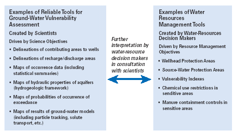 |
| Figure 14. The interpretation and practical use of an assessment is best served by interactions and feedback between the scientists and the decision makers. This is particularly true as the complexity of an assessment increases. These interactions and feedback can remove some of the need for overly simplistic assessments that produce subjective categorizations. Successful ground-water-vulnerability assessments blend scientifically defensible analyses based on clear science objectives with additional interpretations by water-resource decision makers to meet management or policy objectives. |
We are grateful for the thoughtful technical reviews of this Circular provided by Wayne W. Lapham, Gregory E. Granato, Janice R. Ward, William M. Alley, and William L. Cunningham. Many other U.S. Geological Survey colleagues including Jack E. Barbash and Bernard T. Nolan provided important insights and comments. We are also grateful to Sandra C. Cooper for her thorough editorial review and Patricia S. Greene for preparing the final manuscript and illustrations.
Aller, L., Bennett, T., Lehr, J.H., and Petty, R.J., 1985, DRASTIC- A standardized system for evaluating ground water pollution potential using hydrogeologic settings. U.S. Environmental Protection Agency report EPA/600/2-85/018, 163 p.
Alley, W.M., 1993, Regional Ground Water Quality, Van Nostrand Reinhold, New York, NY. 635 p.
Alley, W.M., Reilly, T.E., and Franke, O.L., 1999, Sustainability of ground-water resources. U.S. Geological Survey Circular 1186, 79 p.
American Society for Testing and Materials, 2000, Standard guide for selection of methods for assessing ground water or aquifer sensitivity and vulnerability. ASTM, West Conshohocken, PA. 19 p.
Arnold, T.L. and Friedel, M.J., 2000, Effects of land use on recharge potential of surficial and shallow bedrock aquifers in the Upper Illinois River basin. U. S. Geological Survey Water-Resources Investigations Report 00-4027, 18 p.
Back, W., Baedecker, M.J., and Wood, W.W., 1993, Scales in chemical hydrogeology: A historical perspective, in Regional Ground Water Quality (William Alley, editor): Van Nostrand Reinhold, New York, NY, p. 111-128.
Barbash, J.E., and Resek, E.A., 1996, Pesticides in ground water-distribution, trends, and governing factors: Chelsea, Mich., Ann Arbor Press, Inc., 588 p.
Barrett, M.R., and Williams, W.M., 1989, Occurrence of atrazine in ground water as a result of agricultural use, in Pesticides in Terrestrial and Aquatic Environments, May 11-12, 1989, Proceedings: Blacksburg, Virginia, Virginia Water Resources Research Center, p. 39-61.
Bohlke, J.K., and Denver, J.M., 1995, Combined use of groundwater dating, chemical, and isotopic analyses to resolve the history and fate of nitrate contamination in two agricultural watersheds, Atlantic Coastal Plain, Maryland. Water Resources Research v. 31, no. 9, pp 2319-2339.
Chapelle, F.H., Robertson, J.F., Landmeyer, J.E., and Bradley, P.M., 2000, Methodology for applying monitored natural attenuation to petroleum hydrocarbon-contaminated ground-water systems with examples from South Carolina. U.S. Geological Survey Water-Resources Investigations Report 00-4161. 47 p.
Coplen, T. B., Herczeg, A. L., and Barnes, C., 1999, Isotope Engineering - Using stable isotopes of the water molecule to solve practical problems: in Environmental tracers in subsurface hydrology (P.G. Cook and A.L. Herczeg, editors): Kluwer Academic Publishers, Boston, MA, p. 79-110.
Dean, Y.J., and Meeks, J.D., 1990, Evaluating ground-water vulnerability to pesticides. Journal of Water Resources Planning and Management, vol. 116, no. 5, p. 693-707.
Duncan, D., Pederson, D.T., Shepherd, T.R., and Carr, J.D., 1991, Atrazine used as a tracer of induced recharge: Ground Water Monitoring Review, v. 11, no. 4, p. 144-150.
Durnford, D.S., Thompson, K.R., Ellerbrook, D.A., Loftis, J.C., and Davies, G.S., 1990, Screening methods for ground water pollution potential from pesticide use in Colorado agriculture: Colorado Water Resources Research Institute, Fort Collins, Completion Report No. 157, 165 p.
Erwin, M.L., and Tesoriero, A.J., 1997, Predicting ground-water vulnerability to nitrate in the Puget Sound Basin: U.S. Geological Survey Fact Sheet 061-97, 4 p.
Focazio, M.J., Z. Szabo, T.F. Kraemer, A.H. Mullin, T.H. Barringer, and V.T. dePaul, 2000, Occurrence of selected radionuclides in ground water used for drinking water in the United States: A reconnaissance survey, 1998. U.S. Geological Survey Water-Resources Investigations Report 00-4273. 40 p.
Garrett, P., Williams, J.S., Rossoll, C.F., and Tolman, A.L., 1989, Are ground water vulnerability classification systems workable in FOCUS Conference on Eastern Regional Ground Water Issues, Kitchener, Ontario, Canada, October 17-19, Proceedings: National Water Well Association, Dublin, Ohio, p. 329-343.
Greene, E.A., 1997, Tracing recharge from sinking streams over spatial dimensions of Kilometers in a karst aquifer. Ground Water, vol. 33., no.5. pp. 898-904
Gustafson, D.A., 1990, Field calibration of SURFACE: a model of agricultural chemicals in surface waters. Journal of Environmental Science and Health, v. 25, no. 5, p. 665-687.
Haan, C.T., 1977, Statistical methods in hydrology. The Iowa State University Press. Ames, Iowa. 378 p.
Hamerlinck, J.D., and Ameson, C.S., 1998, Wyoming ground water vulnerability assessment handbook: University of Wyoming, Laramie, Wyoming, Spatial Data Visualization Center, Report SDVC 98-01, 2 Volumes, Accessed December 2000 at URL http://www.sdvc.uwyo.edu/groundwater/report.html.
Harbaugh, A.W., Banta, E.R., Hill, M.C., and McDonald, M.G., 2000, MODFLOW-2000, The U.S. Geological Survey Modular Ground-Water Model – Users guide to modularization concepts and the ground-water flow process. U.S. Geological Survey Open-File Report 00-92, 121 p.
Hearne, G.A., Wireman, M., Campbell, A., Turner,
S., and Ingersoll, G.P., 1992, Vulnerability of the uppermost ground water to
contamination in the Greater Denver area, Colorado. U.S. Geological Survey Water-Resources
Investigations Report 92-4143, 243 p.
Heath, R.C., 1983, Basic ground-water hydrology. U.S. Geological
Survey Water-Supply Paper 2220, 84 p.
Helsel, D.R. and Hirsch, R.M., 1992, Statistical Methods in Water Resources. Elsevier Publishers, New York, 529 p.
Hill, M.C., Banta, E.R., Harbaugh, A.W., and Anderman, E.R., 2000, Documentation of MODFLOW-2000, the U.S. Geological Survey modular ground-water model, User's guide to the Observation, Sensitivity, and Parameter-Estimation Process and three post-processing programs: U.S. Geological Survey Open-File Report 00-184, 209p.
Holden, L.R., J.A. Graham, R. W. Whitmore, W.J. Alexander, R. W. Pratt, S.K. Liddle, and L.L. Piper, 1992, Results of the National Alachlor Well Water Survey. Environmental Science and Technology 26 (5), p. 935-943.
Holtschlag, D.J., and C.L. Luukkonen, 1997, Vulnerability of ground water to atrazine leaching in Kent County, Michigan. U.S. Geological Survey Water-Resources Investigations Report 96-4198. 49 p.
Johansson, P.O., Scharp, C., Alveteg, T., Choza, A., 1999, Framework for ground-water protection-the Managua Ground Water System as an example. Ground Water, v. 37, no. 2, p. 204-213.
Katz, B.G., Hornsby, H.D., Bohlke, J.K., Mokray, M.F., 1999, Sources and chronology of nitrate contamination in spring waters, Suwanee River Basin, Florida. U.S. Geological Survey Water-Resources Investigations Report 99-4252. 54 p.
Kellogg, R.L., Wallace, S., Alt, K., and Goss, D.W., 1997, Potential priority watersheds for protection of water quality from nonpoint sources related to agriculture: Poster Presentation at the 52nd Annual SWCS Conference, Toronto, Ontario, Canada, July 22-25, 1997, Accessed December 2000 at URL http://www.nhq.nrcs.usda.gov/land/pubs/wqpost2.html.
Kim, Y.J., and Hamm, S., 1999, Assessment of the potential for ground water contamination using the DRASTIC/EGIS technique, Cheongju area, South Korea: Hydrogeology Journal, vol. 7, no. 2, p. 227-235.
Kolpin, D.W., Kalkhoff, S.J., Goolsby, D.A., Sneck-Fahrer, D.A., and Thurman, E.M., 1997, Occurrence of selected herbicides and herbicide degradation products in Iowa's ground water, 1995. Ground Water, v. 35, no. 4, p. 679-688.
Koterba, M.T., Banks, W.S.L., and Shedlock, R.J., 1993, Pesticides in shallow groundwater in the Delmarva Peninsula. Journal of Environmental Quality, v. 22, no. 3, p. 500-518.
LeBlanc, D.R., Garabedian, S.P., Hess, K.M., Gelhar, L.W., Quadri, R.D., Stollenwerk, K.G., and Wood, W.W., 1991, Large-scale natural gradient tracer test in sand and gravel, Cape Cod, Massachusetts – 1. Experimental design and observed tracer movement. Water Resources Research, vol. 27, no. 5, p. 895-910.
Loague, K., Bernknopf, R.L., Green, R.E., and Giambelluca, T.W., 1996, Uncertainty of groundwater vulnerability assessments for agricultural regions in Hawaii: Review. Journal of Environmental Quality 25, p. 475-490
Lobo-Ferreira, J.P., and Oliveira, M.M., 1997, DRASTIC ground water vulnerability mapping of Portugal: Proceedings from the 27th Congress of the International Association for Hydraulic Research, San Francisco, USA, Aug. 10-15, p. 132-137, Accessed December 2000 at http://www-dh.lnec.pt/gias/novidades/drastic_e.html.
Lynch, S.D., Reynders, A.G., and Schulze, R.E., 1994, Preparing input data for a national-scale ground water vulnerability map of Southern Africa. Water S. A., v. 20, no. 3, p. 239-246.
Lynch, S.D., Reynders, A.G., and Schulze, R.E., 1997, A DRASTIC approach to ground water vulnerability in South Africa. South African Journal of Science, v. 93, no. 2, p. 59-60.
Masterson, J.P., and Walter, D.A., 2000, Delineation of ground-water recharge areas, western Cape Cod, Massachusetts. U.S. Geological survey Water Resources Investigations Report 00-4000, 1 plate.
Masterson, J.P., Walter, D.A., and LeBlanc, D.R., 1998, Delineation of contributing areas to selected public-supply wells, western Cape Cod, Massachusetts. U.S. Geological survey Water Resources Investigations Report 98-4237, 45 p.
Melloul, M., and Collin, M., 1998, A proposed index for aquifer water-quality assessment: the case of Israel's Sharon region: Journal of Environmental Management, v. 54, no. 2, p. 131-142.
Merriam-Webster's Collegiate Dictionary, 1996, Tenth Edition, Merriam-Webster, Inc. Springfield Massachusetts. pp. 1559
Morgan, L., 1998, Draft interim report on PATRIOT trial run for the State of Washington Interagency Ground-water Committee, Aquifer Vulnerability Subcommittee: Washington State Department of Ecology, Water Quality Program, Watershed Management Section, Olympia, WA, 17 p., 7 appendices.
Mueller, T.C., 1994, Comparison of PRZM computer model predictions with field lysimeter data for dichlorprop and bentazon leaching. Journal of Environmental Science and Health Part A, v. A29, no. 6, p. 1183-1195.
Mueller, D.K., Ruddy, B.C., and Battaglin, W.A.,1997, Logistic model of nitrate in streams of the upper-midwestern United States. Journal of Environmental Quality v. 26, no. 5, p. 1223-1230.
National Research Council, 1993, Ground water vulnerability assessment, contamination potential under conditions of uncertainty: National Academy Press, Washington, D.C., 210 p. Accessed December 2000 at URL http://books.nap.edu/books/0309047994/html.
Niccoli, W.L., Loftis, J.C., Durnford, D.S., and Butters, G., 1989, Potential pesticide transport in Colorado agriculture; a model comparison: Colorado Water Resources Research Institute, Fort Collins, Completion Report No. 156, 96 p.
Nolan, B.T., Hitt, K.J., Ruddy, B.C., 2002, Probability of nitrate contamination of recently recharged groundwaters in the conterminous United States. Environmental Science and Technology, v. 36 n. 10, p. 2138 - 2145.
Nolan, B.T., 1998, Modeling approaches for assessing the risk of nonpoint-source contamination of ground water. U.S. Geolgical Survey Open-File Report 98-531. 15 p.
Nolan, B.T., Ruddy, B.C., Hitt, K.J., and Helsel, D.R., 1998, A National look at nitrate contamination of ground water: Water Conditioning and Purification, v. 39, no. 12, pages 76-79, Accessed December 2000 at URL http://water.usgs.gov/nawqa/wcp.
Nolan, B.T., Ruddy, B.C., Hitt, K.J, and Helsel, D.R., 1997, Risk of nitrate in groundwaters of the United States - a national perspective. Environmental Science and Technology v. 31, no. 8, p. 2229-2236.
Perry, C.A., 1991, Observed and simulated distribution of selected herbicides in silty loam, sandy loam, and clay soil profiles near Topeka, Kansas, 1986-88. U.S. Geological Survey Water-Resources Investigations Report 91-4017, 61 p.
Plummer, L.N., Busenberg, E., McConnell, J.B., Drenkard, S., Schlosser, P., and Michel, R.L., 1998, Flow of river water into a Karstic limestone aquifer. 1. Tracing the young fraction in groundwater mixtures in the Upper Floridan Aquifer near Valdosta, Georgia. Applied Geochemistry, v. 13, no. 8, p. 995-1015.
Plummer, L.N., Michel, R.L., Thurman, E.M., and Glynn, P.D., 1993, Environmental tracers for age dating young ground water: in Regional ground-water quality (William Alley, editor): Van Nostrand Reinhold, New York, NY, p. 255-294.
Pollock, D.W., 1994, User's guide for MODPATH/MODPATH-PLOT, version 3: A particle tracking post processing package for MODFLOW, the U.S. Geological Survey finite-difference ground-water-flow model. U.S. Geological Survey Open-File Report 94-464, 249 p.
Rao, P.S.C., and Alley, W.M., 1993, Pesticides: in Regional Ground-Water Quality (W.M. Alley, editor): Van Nostrand Reinhold, New York, NY, p. 345-377.
Regional Groundwater Center, 1995, Groundwater vulnerability study for Tyrone Township, Livingston County, Michigan. Regional Groundwater Center, University of Michigan-Flint, Flint, Michigan. Accessed December 2000 at URL http://www.flint.umich.edu/Departments/RegionalGroundwater/tyreport.htm.
Reilly, T.E., 1993, Analysis of ground-water systems in freshwater-saltwater environments: in Regional Ground-Water Quality (W.M. Alley, editor): Van Nostrand Reinhold, New York, NY, p. 443-469.
Reilly, T. E., and Pollock, D. W., 1993, Factors affecting areas contributing recharge to wells in shallow aquifers: U.S. Geological Survey Water-Supply Paper 2412, 21 p.
Reilly, T.E., Plummer, L.N., Phillips, P.J., Busenberg, E., 1994, The use of simulation and multiple environmental tracers to quantify ground-water flow in a shallow aquifer. Water Resources Research, v. 30, no. 2, pp. 421-433.
'Reilly, T.E., 2001, System and boundary conceptualization in ground-water-flow simulation. Techniques of Water-Resources Investigations of the U.S. Geological Survey Book 3, Applications of Hydraulics, Chapter B8, 30 p.
Rosen, L., 1994, A study of the DRASTIC methodology with emphasis on Swedish conditions: Ground Water, v. 32, no. 2, p. 278-285.
Rowe, G.L., Dunkle Shapiro, S., Schlosser, P., 1999, Use of environmental tracers to evaluate ground-water age and water-quality trends in a buried-valley aquifer, Dayton area, Southwestern, Ohio. U.S. Geological Survey Water-Resources Investigations Report 99-4113. 81 p.
Rupert, M.G., 1998, Probability of detecting
atrazine/desethyl-atrazine and elevated concentrations of nitrate in ground
water of the Idaho part of the upper Snake River Basin. U.S.Geological Survey
Water-Resources Investigations Report 98-4203. 27 p.
Rupert, M.G., 2001, Calibration of the DRASTIC ground water vulnerability mapping
method. Ground Water, v. 39, no. 4, pp. 625-630.
Rutledge, A.T., and Helgesen, J.O., 1991, A steady-state unsaturated-zone model to simulate pesticide transport. U.S. Geological Survey Water-Resources Investigations Report 90-4164, 13 p.
Ryker, S.J., Nov. 2001, Mapping arsenic in ground water— A real need, but a hard problem. Geotimes Newsmagazine of the Earth Sciences, v. 46, no. 11, p. 34-36
Ryker, S.J. and Williamson, A.K., 1996, Pesticides in Public Supply Wells of Washington State. U.S. Geological Survey Fact Sheet FS-122-96, 2 p.
Sadeghi, A.M., Isensee, A.R., and Shirmohammadi, A., 1995, Atrazine movement in soil: comparison of field observations and PRZM simulations. Journal of Soil Contamination, v. 4, no. 2, p. 151-161.
Seelig, B., 1994, An Assessment System for Potential Groundwater Contamination from Agricultural Pesticide Use in North Dakota: North Dakota North Dakota State University Extension Service, Extension Bulletin No. 63, Accessed December 2000 at URL http://www.ext.nodak.edu/extpubs/h2oqual/watgrnd/eb63w.htm.
Seiler, R.L., Skorupa, J.P., and Peltz, L.A., 1999a, Areas Susceptible to Irrigation-Induced Selenium Contamination of Water and Biota in the Western United States. U.S. Geological Survey Circular 1180, 36 p.
Seiler, R.L., Zaugg, S.D., Thomas, J.M., Howcroft, D.L., 1999b, Caffeine and pharmaceuticals as indicators of waste water contamination in wells. Ground Water, v. 37, no. 3, p. 405-410.
Shapiro, A.M., and Hsieh, P.A., 1998, How good are estimates of transmissivity from slug tests in fractured rock? Ground Water, v. 36, n. 1, pp 37-48.
Shelton, J.L., Burow, K.R., Belitz, K., Dubrovsky, N.M., Land, M., Gronberg, J., 2001, Low-level volatile organic compounds in active public supply wells as ground-water tracers in the Los Angeles Physiographic Basin, California, 2000.
Shukla, S., Mostaghimi, S., Shanholt, V.O., Collins, M.C., and Ross, B.B., 2000, A county-level assessment of ground water contamination by pesticides. Ground Water Monitoring and Review, v. 20, no. 1, p. 104-119.
Snyder, D.T., Wilkinson, J.M., and Orzol, L.L., 1998, Use of a ground-water flow model with particle tracking to evaluate ground-water vulnerability, Clark County, Washington. U.S. Geological Survey Water-Supply Paper 2488, 63 p.
Squillace, P.J., Moran, M.J., Lapham, W.W., Price, C.V., Clawges, R.M., and Zogorski, J.S., 1999, Volatile organic compounds in untreated ambient groundwater of the United States, 1985-1995. Environmental Science & Technology, v. 33, no. 23, p. 4176-4187.
Squillace P., and Moran, M., 2000, Estimating the likelihood of MTBE occurrence in drinking water supplied by ground-water sources in the Northeast and Mid-Atlantic Regions of the United States. U.S. Geological Survey, Open File Report 00-343, 10 p.
Starn, J.J., Radway Stone, J., Mullaney, J.R., 2000, Delineation and analysis of uncertainty of contributing areas to wells at the southbury training school, Southbury, Connecticut. U.S. Geological Survey Water-Resources Investigations Report 00-4158, 54 p.
Stute, M., Deák, J., Révész, K., Böhlke, J.K., Deseö, E., Weppernig, R., and P. Schlosser, 1997, Tritium/3He dating of river infiltration: An example from the Danube in the Szigetköz area, Hungary. Ground Water, v. 35, no. 5, p. 905-911.
Taylor, C.J., 1997, Delineation of ground-water basins and recharge areas for municipal water-supply springs in a karst aquifer system in the Elizabethtown area, Northern Kentucky. U.S. Geological Survey Water-Resources Investigations Report 96-4254. 22 p.
Tesoriero, A.J., and Voss, F.D., 1997, Predicting the probability of elevated nitrate concentrations in the Puget Sound basin: Implications for aquifer susceptibilityand vulnerability. Ground Water, v. 35, no. 6, pp. 1029-1039
U.S. Environmental Protection Agency, 1993a, A review of methods for assessing aquifer sensitivity and ground water vulnerability to pesticide contamination. U.S. Environmental Protection Agency, EPA/813/R-93/002, 147 p.
--- 1993b, PRZM-2, A Model for Predicting Pesticide Fate in the Crop Root and Unsaturated Soil Zones: User Manual for Release 2.0. U.S. Environmental Protection Agency, EPA 600/R-93/045, 406 p.
--- 1994, PATRIOT--A methodology and decision support system for evaluating the leaching potential of pesticides: U.S. Environmental Protection Agency, EPA 600/S-93/010, 8 p.
--- 1997, State source water assessment and protection programs guidance. Final Guidance U.S. Environmental Protection Agency, EPA816-R-97-009, 127 p.
Villumsen, A; Sonderskov, C., 1982, Vulnerability
Maps: A Promising Tool in Groundwater Protection: Aqua No 5, Denmark, p. 0466-0468.
Vowinkel, E.F., Clawges, R.M., Buxton, D.E., Stedfast,
D.A., and Louis, J.B., 1996, Vulnerability of public drinking water supplies
in New Jersey to pesticides. U.S. Geological Survey Fact Sheet FS-165-96, 3
p.
Welch, A.H., Westjohn, D.B., Helsel, D.R., and Wanty, R.B., 2000, Arsenic in ground water of the United States – Occurrence and geochemistry. Ground Water, v. 38, no. 4, p. 589.
Whitehead, R.L., 1992, Geohydrologic framework of the Snake River Plain regional aquifer system, Idaho and eastern Oregon. U.S. Geological Survey Professional Paper 1408B, 32 p., 6 pls.
Wilson, W.E., and Moore, J.E., editors, 1998,
Glossary of Hydrology: American Geological Institute, Alexandria, Virginia,
248 p.