U.S. Geological Survey: Science for a Changing World - USGS visiaul identifier and link to main Web site at http://www.usgs.gov/

Map showing locations of major occurrences of Grenville-age basement in eastern North America. For a more detailed explanation, contact Richard Tollo at rtollo@gwu.edu.     
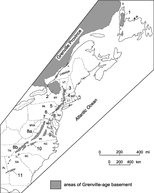
Figure 1. Map showing locations of major occurrences of Grenville-age basement in eastern North America. Labelled areas include: 1, Long Range massif; 2, Adirondack massif; 3, Green Mountains massif; 4, Berkshire massif; 5, Hudson Highlands–New Jersey Highlands–Reading prong; 6, Honey Brook upland; 7, Baltimore Gneiss antiforms; 8, Blue Ridge province, including Shenandoah (8a) and French Broad (8b) massifs; 9, Goochland terrane; 10, Sauratown Mountains anticlinorium; and 11, Pine Mountain belt. Map modified after Rankin and others (1989a).

U.S. Department of the Interior, U.S. Geological Survey
URL: https:// pubsdata.usgs.gov /pubs/circ/2004/1264/html/trip2/fig1.html
For more information, contact Richard Tollo
Maintained by Reston Publications Service Center
Last modified: 12:24:06 Wed 23 Nov 2016
Privacy statement | General disclaimer | Accessibility