U.S. Geological Survey: Science for a Changing World - USGS visiaul identifier and link to main Web site at http://www.usgs.gov/

Relative sea-level curve for the Upper Devonian-Lower Mississippian (upper Famennian-lower
       Tournaisian) Rockwell Formation of western Maryland. For a more detailed explanation, contact Blaine Cecil at bcecil@usgs.gov
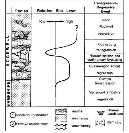
Figure 25. Relative sea-level curve for the Upper Devonian-Lower Mississippian (upper Famennian-lower Tournaisian) Rockwell Formation of western Maryland (based on Beuthin (1986a) with minor modifications). Curve does not indicate absolute magnitude, nor absolute duration of any sea-level event. Devonian-Mississippian transition probably occurred during the time-interval encompassing Cussewago-Bedford regression or "Berea" incision and sedimentary bypassing.

U.S. Department of the Interior, U.S. Geological Survey
URL: https:// pubsdata.usgs.gov /pubs/circ/2004/1264/html/trip3/fig25.html
For more information, contact Blaine Cecil
Maintained by Reston Publications Service Center
Last modified: 12:23:51 Wed 23 Nov 2016
Privacy statement | General disclaimer | Accessibility