U.S. Geological Survey: Science for a Changing World - USGS visual identifier and link to main Web site at http://www.usgs.gov/

Photograph taken at Stop 4, Great Falls Park, Va., looking north at steeply dipping layers of folded metagraywacke and schist of the Mather Gorge Formation in the Potomac River at the type-locality. For a more detailed explanation, contact Michael Kunk at mkunk@usgs.gov. Photograph taken at Stop 4, Great Falls Park, Va., looking east at the lamprophyre dikes (see arrows) that intruded north-dipping fractures in metagraywacke and schist of the Mather Gorge Formation.For a more detailed explanation, contact Michael Kunk at mkunk@usgs.gov.

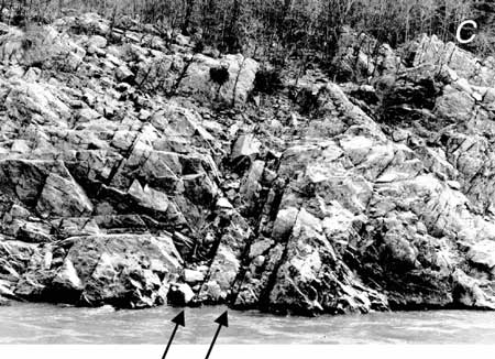
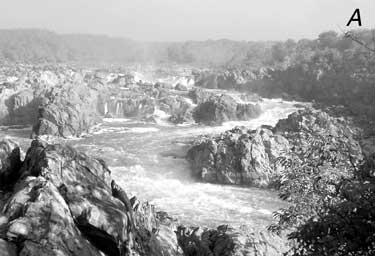
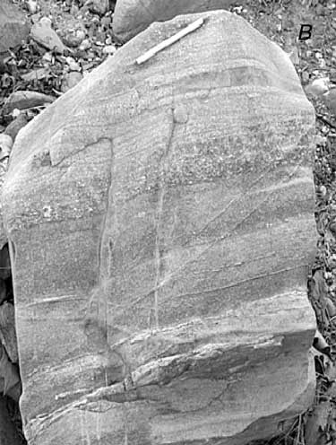
Figure 11. Photographs of Stop 4, Great Falls Park, Va. A, Looking north at steeply dipping layers of folded metagraywacke and schist of the Mather Gorge Formation in the Potomac River at the type-locality. B, Closeup of a boulder of metagraywacke showing graded beds and subangular feldspar deposited in turbidite sequences. Pen is 14 cm long. C, Looking east at the lamprophyre dikes (see arrows) that intruded north-dipping fractures in metagraywacke and schist of the Mather Gorge Formation. The dikes have a ~360-Ma conventional K-Ar biotite cooling age. Potomac River is in the foreground.

Photograph taken at Stop 4, Great Falls Park, Va., showing closeup of a boulder of metagraywacke showing graded beds and subangular feldspar deposited in turbidite sequences. For a more detailed explanation, contact Michael Kunk at mkunk@usgs.gov.

U.S. Department of the Interior, U.S. Geological Survey
URL: https:// pubsdata.usgs.gov /pubs/circ/2004/1264/html/trip5/fig11.html
For more information, contact Michael Kunk
Maintained by Reston Publications Service Center
Last modified: 12:24:36 Wed 23 Nov 2016
Privacy statement | General disclaimer | Accessibility