U.S. Geological Survey: Science for a Changing World - USGS visual identifier and link to main Web site at http://www.usgs.gov/

Photograph of complex rocks exposed at Stop 6 immediately west of the American Legion Bridge on a scoured section along the Potomac River, in the Stubblefield Falls domain. For a more detailed explanation, contact Michael Kunk at mkunk@usgs.gov.
 
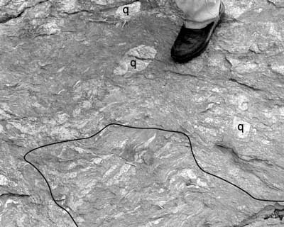
Figure 13. Photograph of complex rocks exposed at Stop 6 immediately west of the American Legion (I-495) Bridge on a scoured section along the Potomac River, in the Stubblefield Falls domain. These rocks were interpreted by Drake and Froelich (1997) to be olistoliths of Mather Gorge Formation and quartz cobbles in a Sykesville Formation matrix. The outcrop consists of disrupted, foliated blocks of Mather Gorge Formation (outlined in lower part of photograph) and dismembered quartz veins (q) associated with a small amount of migmatite. Man's foot is 10 cm wide. Potomac River is to the right of the photographed area.

U.S. Department of the Interior, U.S. Geological Survey
URL: https:// pubsdata.usgs.gov /pubs/circ/2004/1264/html/trip5/fig13.html
For more information, contact Michael Kunk
Maintained by Reston Publications Service Center
Last modified: 12:24:37 Wed 23 Nov 2016
Privacy statement | General disclaimer | Accessibility