U.S. Geological Survey: Science for a Changing World - USGS visual identifier and link to main Web site at http://www.usgs.gov/

Regression of the seven post-1930 flood levels at the marker post near the scenic overlook at Great Falls Park against the discharge, Q in 1000 cubic feet per second, as recorded at the Little Falls Gauge Station. For a more detailed explanation, contact Paul Bierman at pbierman@zoo.uvm.edu.
 
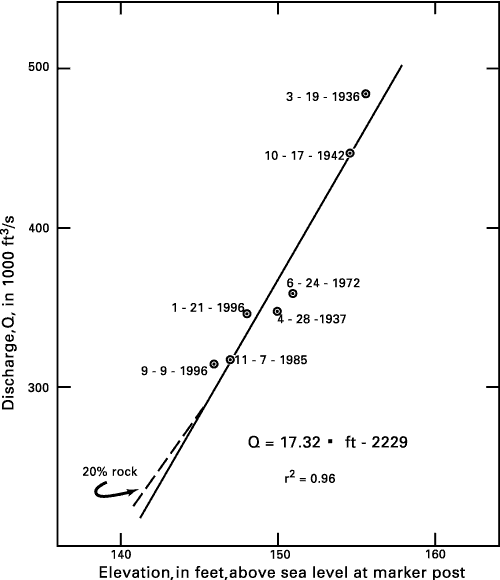
Figure 9. Regression of the seven post-1930 flood levels, in feet asl, at the marker post near the scenic overlook at Great Falls Park against the discharge, Q in 1000 cubic feet per second (1000 ft3/s), as recorded at the Little Falls Gauge Station. Dashed line shows the relation that would obtain if 20 percent of the space between 140 ft and 146 ft were occupied by rocks.


U.S. Department of the Interior, U.S. Geological Survey
URL: https:// pubsdata.usgs.gov /pubs/circ/2004/1264/html/trip6/fig9.html
For more information, contact Paul Bierman
Maintained by Reston Publications Service Center
Last modified: 12:24:43 Wed 23 Nov 2016
Privacy statement | General disclaimer | Accessibility