
The Elevation Of Tufa Deposits And Their Relation To Overflow Points
Elevational History Of Pyramid Lake/Lake Lahontan
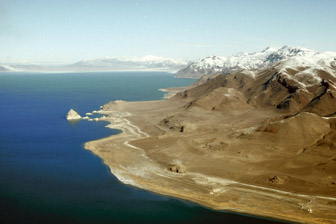
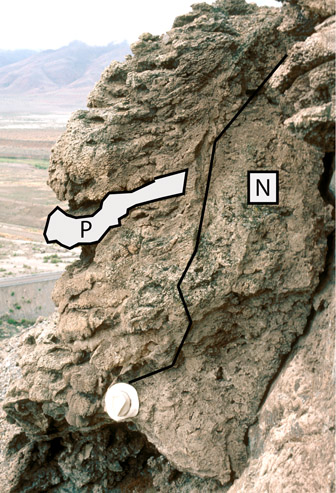
Figure 1. Pyramid Island along the east shore of Pyramid Lake. The white ba...
Figure 2. Pluvial Lake Lahontan at its highstand about 15,000 years ago. Th...
Figure 3. Lake elevation in the Pyramid Lake subbasin between 35,000 and 9,...
Figure 4. Locations of tufa sites described in this report.
Figure 5. Dense tufa coating volcanic cobbles in the Terraced Hills area.
Figure 6. Tubular tufas from the Popcorn Rocks site. The outer light-colore...
Figure 7. Tufa pillows at Doghead Rock composed of branching tufa (B) and d...
Figure 8. Thinolite crystals exposed at the base of the Blanc Tetons site.
Figure 9. Calcium-carbonate cemented thinolite crystals at the Pelican Poin...
Figure 10. Large mushroom tufas at the Pelican Point site composed of layer...
Figure 11. Layers of beachrock adjacent to and north of Indian Head Rock.
Figure 12. The southern Blanc Tetons mound. Large tufa spheroids have been ...
Figure 13. Tufa pillows making up a reef-like tufa on Anaho Island.
Figure 14. Tufa tubes at the base of Dog Head Rock. The tubes range in diam...
Figure 15. Broken tufa barrel at Needles Rocks site. Vertical tubes are com...
Figure 16. Reef-like tufa sheets and drapes near the summit of Anaho Island...
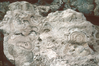
Figure 17. Multiple generations of thinolite crystals inside an overturned ...
Figure 18. The Indian Head Rock tufa mound composed of interlocking tufa sp...
Figure 19. A tufa mound at the Needles Rocks site composed of interlocking ...
Figure 20. The Pyramid Island tufa mound. Note the girdle of carbonate ceme...
Figure 21. The tufa reefs coating Marble Bluff. Note that the tufa pillows ...
Figure 22. Cross-sectional view through a tufa reef at Marble Bluff. The ou...
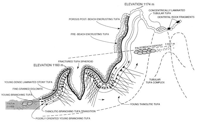
Figure 23. Schematic sequence of tufa deposition at the Blanc Tetons site. ...
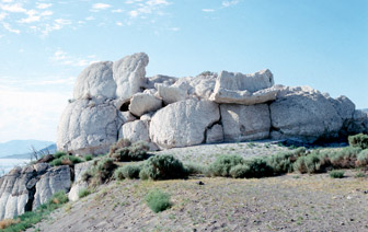
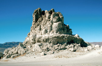
Figure 24. The Needles Rocks site at the north end of Pyramid Lake. The top...
Figure 25. The relation of tufa dome heights and Marble Bluff tufa varietie...
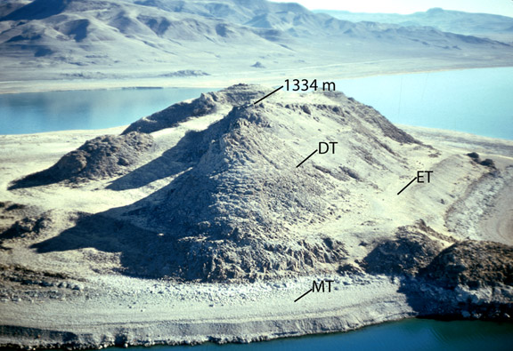
Figure 26. Anaho Island. The top of the island is at an elevation of 1,334 ...
Figure 27. Broken tufa mound at Dog Head Rock showing tubes and surrounding...
Figure 28. Tufa mound at the Needles Rocks site, whose base has been heavil...
Pyramid Lake is the site of some of the Earth's most spectacular tufa deposits. The Tufas are composed of calcium carbonate (CaCO3). The large tufa mounds, reef- and sheet-like tufas formed within Pyramid Lake, between 26,000 and 13,000 years (yr) ago, when the lake was part of pluvial Lake Lahontan. The mounds are composed of large interlocking spheres that contain multiple generations of a crystalline (thinolite) variety of tufa. Over time many of the mounds have fallen apart, exposing an internal network of tubes. The tubular structures are thought to have been created when springs discharged from the bottom of Pyramid Lake, supplying calcium that combined with carbonate dissolved in lake water to form the mounds. The reef- and sheet-like deposits contain pillow and pendant forms made up of a branching variety of tufa that often grades into dense layers or nodules. Dense layers of tufa also coat cobbles and boulders that were deposited in near-shore shallow-water areas. The thickest tufa deposits formed at lake-bottom sites of ground-water discharge and at overflow elevations1 where the lake was held at near-constant levels for long periods of time.
The U.S. Geological Survey, in cooperation with the Pyramid Lake Paiute Tribe, has obtained radiocarbon ages of many of the tufa deposits that border Pyramid Lake in order to obtain a record of lake level change for the past 35,000 years. This record has been used to construct a theory of climate change wherein changes in lake level are associated with the position of the polar jet stream relative to the Lahontan Basin (Benson and others, 1995). When the jet stream passes over the basin, Pyramid Lake increases in size in response to the increased precipitation that accompanies the frontal systems that define the boundary of the jet stream (Benson and others, 1995). The tufa deposits that border Pyramid Lake are unique in terms of their size and beauty. By drawing attention to their history of formation we hope to alert the public to their special nature and the need for their preservation.
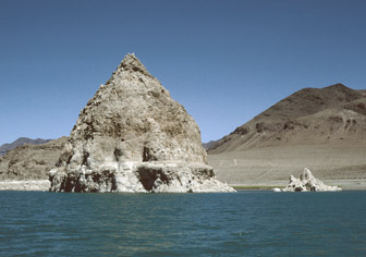
Tufa is a rock composed of calcium carbonate (CaCO3) that forms at the mouth of a spring, from lake water, or from a mixture of spring and lake water. Tufas in the Pyramid Lake subbasin were first mentioned in the literature by Fremont (1845), who erroneously believed they had formed above water. Fremont named the lake after the pyramidal-shaped island that lies along the eastern shore of the lake (Fig. 1). The Paiute name for the island is Wono, meaning cone-shaped basket; and the Paiute name for the lake is Cui-Ui Panunadu, meaning fish in standing water.
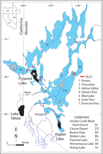
Pyramid Lake is one of seven water bodies that coalesced to form pluvial Lake Lahontan (Fig. 2). At its highstand, Lake Lahontan was 281 m deep in the Pyramid Lake subbasin (compared to 106 m today) and covered 22,800 km2, a surface area slightly larger than present-day Lake Ontario. During the very wet period that caused Lake Lahontan to form and grow (Fig. 3), massive tufa deposits formed in the Pyramid Lake subbasin (Benson and others, 1995).
The locations of tufas described in this report are shown in Figure 4. Pyramid Lake tufas can be classified, if somewhat arbitrarily, by variety, form, and megaform. Russell (1885) was the first to suggest that there were three tufa varieties, including lithoid (dense), thinolitic (crystalline), and dendritic (branching). Two other varieties have been noted in the Pyramid Lake area: A fine-grained carbonate that cements sand and gravel forming beachrock, and a thin white porous carbonate that coats the outer surfaces of older tufas.
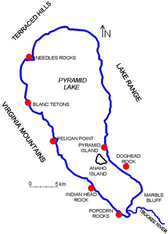
Figure 4. Locations of tufa sites described in this report.
The dense variety of tufa is found as a coating on gravel and cobbles (Fig. 5), as concentric layers in the outer parts of tubes (Fig. 6), and as nodules and pendants that formed when branching tufa coalesced (Fig. 7). Thinolitic tufa consists of long fragile crystals (Fig. 8); however, if the thinolitic tufa is later exposed to lake water, it may become cemented with additional CaCO3, giving it a dense and massive appearance (Fig. 9). Branching tufa often looks like composite heads of broccoli (Fig. 10); however, it can assume other forms (for example, Fig. 7). Beachrock forms where calcium-rich ground water mixes with carbonate--rich lake water, precipitating CaCO3 that cements sand and gravel into concrete-like layers. Layers of beachrock are visible at the Indian Head Rock site (Fig. 11) and just upslope from the Popcorn Rocks site. A porous white coating of tufa can be found on the bases of many of the mounds that surround Pyramid Lake (Fig. 12). The coating does not extend above an elevation of 1,183 m and probably formed at times during the last 9,500 years when the lake was below its overflow point to Winnemucca Lake subbasin.
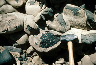
Figure 5. Dense tufa coating volcanic cobbles in the Terraced Hills area.
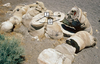
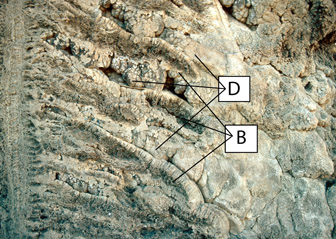

Figure 8. Thinolite crystals exposed at the base of the Blanc Tetons site.
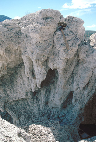
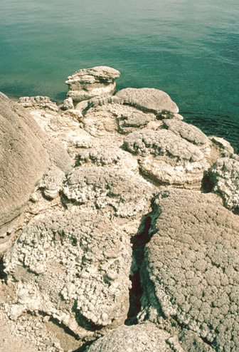
Figure 11. Layers of beachrock adjacent to and north of Indian Head Rock.
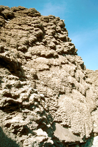
Tufa varieties combine to become tufa forms. Common forms include: (1) tufa pillows (Figs. 7, 13), composed of branching tufa and dense tufa nodules; (2) tufa tubes, composed of dense (Fig. 14) or branching (Fig. 15) varieties of tufa that sometime surround a thinolitic crystal mesh (Fig. 8); (3) tufa sheets and drapes (Fig. 16), which are primarily composed of branching tufa; and (4) tufa spheres or barrels (Fig. 17), commonly composed of one or more layers of thinolitic crystals. In some situations, tufa forms combine to create tufa megaforms, such as tufa mounds (Figs.12, 18, 19, 20) and tufa reefs (Figs. 21, 22). The constructional history of the mounds can be complex as indicated by a structural schematic of the Blanc Tetons mound (Fig. 23). At this site, tubes in the center of the mound are overlain by a thick layer of thinolitic tufa (Fig. 8). The next layer that was deposited consists of thinolitic tufa that grades into a branching variety of tufa. Two layers of branching tufa were then deposited and capped by a thin layer of dolomite (CaMg(CO3)2) and a dense layer of laminated tufa. Two layers of porous encrusting tufa coat the laminated tufa.
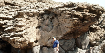
Figure 13. Tufa pillows making up a reef-like tufa on Anaho Island.
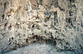
Figure 14. Tufa tubes at the base of Dog Head Rock. The tubes range in diameter from 1 to 3 cm.
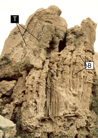
Figure 16. Reef-like tufa sheets and drapes near the summit of Anaho Island.
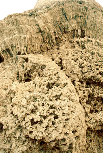
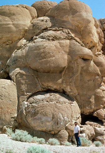
Figure 18. The Indian Head Rock tufa mound composed of interlocking tufa spheres and barrels.
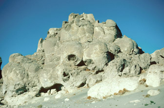
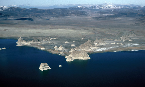
The largest collection of mounds occurs at the north end of Pyramid Lake at the Needles Rocks site. At this site, calcium from hot springs mixed with carbonate from lake water to form mounds that straddle two fault lines (Fig. 24).
Thinolitic tufas, or thinolites are thought to be chemical precipitates that originally had the composition CaCO3.6H2O; that is, they precipitated as the mineral ikaite, which suggests the presence of very cold water (Shearman and others, 1989). The thinolites have since recrystallized to a more stable form of calcium carbonate (calcite). Given their fragile nature, the ikaite crystals probably grew within lake sediments. The branching variety of tufa may have been deposited in association with algae. Enormous calcareous cyanobacterial (blue-green algae) microbialities (stromatolites) that resemble Pyramid Lake tufa mounds have been found growing in the saline waters of Lake Van, Turkey (Kemp and others, 1991). The dense forms of tufa may have precipitated chemically (for example, cobble coatings) or they may have been associated with algae (for example, the concentric dense layers that formed the outer parts of tubular tufas).
Because tufas form in lake water, it follows that their vertical growth is limited by lake level. In the Pyramid Lake subbasin, the elevations of the tops of many tufa mounds correspond to elevations of intersubbasin overflow points (Fig. 2). The tops of the tallest mounds in the Needles Rocks site (Figs. 4, 24) and the top of Pyramid Island (Fig. 20) reach the height of Darwin Pass Sill that connects the Pyramid Lake and Carson Desert subbasins (Fig. 2). The eroded top of Indian Head Rock (Figs. 4, 18) reaches 1,207 m, the same elevation as the Emerson Pass Sill that connects the Pyramid Lake and Smoke Creek-Black Rock Desert subbasins (Fig. 2). Tops of mounds at the Pelican Point, Popcorn Rocks, and Blanc Tetons sites (Fig. 4) have been eroded to 1,177 m, the present elevation of the Mud Lake Sill that connects the Pyramid Lake and Winnemucca Lake subbasins (Fig. 2). The elevations of tufa forms and varieties that coat bedrock on the sides of the Pyramid Lake subbasin also can be related to overflow elevations. Figure 25 shows the relation of tufa dome heights and Marble Bluff tufa forms and varieties to overflow elevations.
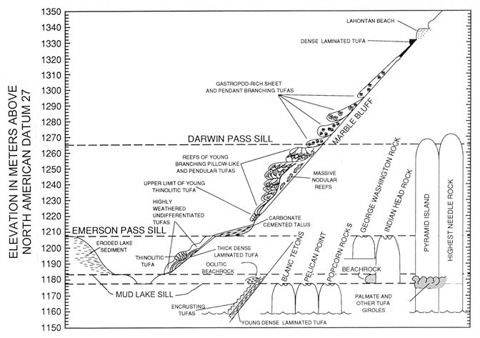
When the level of Pyramid Lake was held constant by overflow to an adjacent subbasin, erosion of tufa and sediment occurred at and slightly above the overflow level, and deposition of tufa occurred below the overflow level. Four principal terraces were created by both erosional and constructional processes at elevations of the Lahontan highstand and the Mud Lake, Emerson Pass, and Darwin Pass sills. The lowest of four principal terraces occurs between elevations of 1,177 and 1,183 m, the elevational range of the Mud Lake Sill. The white "bathtub ring" that surrounds Pyramid Lake (Fig. 1) coats this terrace. On Anaho Island this terrace is represented by a broad flat erosional surface that, in some places, is coated with a white carbonate cement (MT in Fig. 26). The middle terrace also is clearly visible on Anaho Island. It consists of a low, relatively flat bench (ET in Fig. 26) that extends from 1,207 to 1,210 m, the elevation of the overflow point (Emerson Pass Sill) to the Smoke Creek Desert. The outer edge of the upper terrace is at 1,267 m, approximately the elevation of the overflow point (Darwin Pass Sill) to the Carson Desert subbasin. The uppermost terrace on Anaho Island (labeled DT in Fig. 26) and on Marble Bluff (Fig. 25) is constructional in nature, consisting of reef-form tufas (pendants and pillows) that extend tens of meters below 1,267 m. A poorly developed erosional terrace also is present at 1,267 m. The highest terrace in the Pyramid Lake subbasin occurs at an elevation of 1,337 m. It consists of a wedge-shaped platform of rounded cobbles and gravel (Fig. 25) and indicates the maximum level achieved by Lake Lahontan about 15,000 years ago. Anaho Island did not record this terrace as the island is only 1,334 m in height.
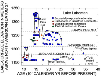
Many of the tufas illustrated in this and other reports (Benson, 1994) have been dated using the radiocarbon method (Benson and others, 1995). The dates were converted to calendar years using a correlation between the layer-counted oxygen-18 (δ18O) record from the Greenland Ice Sheet Project 2 (GISP2) ice core and the radiocarbon dated δ18O record in a sediment core from the North Atlantic (Voelker and others, 1998). The elevations and ages of the tufa samples allow the construction of a lake-level envelope for the last 35,000 years (Fig. 3). The data indicate that the lake in the Pyramid Lake subbasin rose sharply about 26,000 years ago and was maintained at an elevation of about 1,265 m from 25,000 to 18,000 years ago by overflow to the Carson Desert. After a brief fall to less than 1,250 m, Lake Lahontan rose rapidly to its highstand about 15,000 years ago and then fell rapidly about 14,000 years ago.
Deposition of tufa megaforms appears to have ended with the fall of Lake Lahontan between 14,000 and 13,000 years ago (Fig. 3). We do not know why tufa deposition essentially ceased after that time; however, decreases in the discharge of lake-bottom springs may have sharply lessened the amount of calcium available for tufa precipitation. Accurate dates for apparently recent encrusting varieties of tufa are not available. Their ages are estimated to range from 2,055 to 5,820 calendar years before present (BP); however, these estimates may be too large, depending on how much "old" carbon was introduced into the tufas by ground-water sources during their precipitation (Benson and others ,1995). For example, modern tufa, precipitated from a hot spring that emerges from the side of Pyramid Island, has yielded a date of about 1,900 calendar years BP.
Tufa re-exposed to lake water, either by a rise in lake level or by removal of the surrounding lake sediment, may acquire additional calcium carbonate derived from lake water. In addition, areas such as Needles Rocks may have experienced continued discharge of calcium-bearing waters into the bases of the tufa mounds. This younger calcium carbonate may fill preexisting pore spaces in the tufa or add calcium carbonate to the outside of a tufa. Many of the bases of tufa mounds that surround Pyramid Lake have been cemented with younger tufa (Figs. 9, 27), as indicated by the addition of a girdle of calcium carbonate (Figs. 20, 28), whose upper limit is at the elevation of the Mud Lake Sill. Existing data indicate that the level of Pyramid Lake often did not exceed the Mud Lake Sill elevation (1,177-1,183 m) during the past 8,000 years (Benson and others, 2002), suggesting that cementation of the old tufa mounds occurred during that time interval.
Calcium carbonate continues to precipitate from Pyramid Lake's mixed layer. The mixed layer is the volume of warm water that lies above the thermocline (the water layer that separates a warm upper water layer from a cold bottom water layer in a lake) during the warm season. The carbonate (aragonite) makes up 10 to 15 weight percent of Pyramid Lake's sediment (Benson et al., 2002).
Many of the spectacular tufa deposits that surround Pyramid Lake were formed when the climate was much wetter and Pyramid Lake was joined to lakes in nearby basins. At that time (26,000 to 13,000 years ago) many calcium-rich springs discharged from the lake bottom. The calcium in the springs combined with carbonate in the lake water to form large tufa mounds. In addition, many other reef-like tufa deposits formed on rocky headland areas when the level of Pyramid Lake was kept relatively constant during overflow to adjacent lake basins.
The elevations and ages of the tufa allow the construction of a lake-level envelope for the last 35,000 years. The data indicate that the lake in the Pyramid Lake subbasin rose sharply about 26,000 years ago and was maintained at about 1,265 m from 25,000 to 18,000 years ago by overflow to the Carson Desert. After a brief fall to less than 1,250 m, Lake Lahontan rose rapidly to its highstand (1,335 m) about 15,000 years ago and then fell rapidly about 14,000 years ago.
(Footnotes)
1 Elevations in this paper are referenced to North American Datum 83 (NAD 83).
Benson, L.V., 1994, Carbonate deposition, Pyramid Lake subbasin, Nevada: 1. Sequence of formation and elevational distribution of carbonate deposits (tufas): Palaeogeography, Palaeoclimatology, Palaeoecology, vol. 109, p. 55-87.
Benson, L.V., Kashgarian M., and Rubin, M., 1995, Carbonate deposition, Pyramid Lake subbasin, Nevada: 2. Lake levels and polar jet stream positions reconstructed from radiocarbon ages and elevations of carbonate deposits (tufas): Palaeogeography, Palaeoclimatology, Palaeoecology, vol. 117, p. 1-30.
Benson, L., Kashgarian, M., Rye, R., Lund, S., Paillet, F., Smoot, J., Kester, C., Mensing, S., Meko, D., and Lindstrom, S., 2002, Holocene multidecadal and multicentennial droughts affecting northern California and Nevada: Quaternary Science Reviews vol. 21, p. 659-682.
Fremont, J. C., 1845, Report of the Exploring Expedition to the Rocky Mountains in the Year 1843 and to Oregon and North California in the Years 1843-'44: Washington D.C.
Kempe, S., Kazmierczak, J., Landmann, G., Konuk, T., Reimer, A., and Lipp, A., 1991, Largest known microbialites discovered in Lake Van, Turkey: Nature, vol. 349, p. 605-608.
Russell, I. C., 1885, Geological History of Lake Lahontan, a Quaternary Lake of Northwestern Nevada: U. S. Geological Survey Monograph 11, 287 pp.
Shearman, K. J., McGugan, A., Stein, C. and Smith, A. J., 1989, Ikaite CaCO3.6H2O, precusor of the thinolites in Quaternary tufas and tufa mounds of the Lahontan and Mono Lake Basins, western United States: Geology Society of America Bulletin, vol. 101, 913-917.
Voelker, A. H., Sarnthein, M., Grootes, P. M., Erlenkeuser, H., Laj, C., Mazaud, A., Nadeau, M., and Schleicher, M., 1998, Correlation of marine 14C ages from the Nordic seas with the GISP2 isotope record: implications for 14C calibration beyond 25 ka BP.: Radiocarbon, vol. 40, p. 517-534.
Document Accessibility: Adobe Systems Incorporated has information about PDFs and the visually impaired. This information provides tools to help make PDF files accessible. These tools convert Adobe PDF documents into HTML or ASCII text, which then can be read by a number of common screen-reading programs that synthesize text as audible speech. In addition, an accessible version of Acrobat Reader 6.0, which contains support for screen readers, is available. These tools and the accessible reader may be obtained free from Adobe at Adobe Access.
| AccessibilityFOIAPrivacyPolicies and Notices | |
 |
|