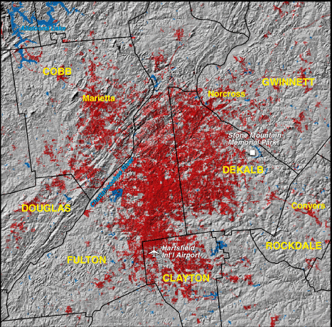
Atlanta, Georgia 1973


|
1970 Population - 1,434,676
Includes Cobb, Douglas, Fulton, Gwinnett, DeKalb, Clayton, and Rockdale Counties. NOTE: portions of the above listed counties may not be visible on the map Red areas shown as developed land 200,800 acres (314 square miles) |
The city of Atlanta, Georgia, was established in the 1840s near the junction of several railroad lines. Its location on the southern Appalachian piedmont made faster transportation routes to other points in the Southeast possible via shorter "interior lines." Railroads remained the city's dominant industry into the 1920s. Before the end of World War I, Atlanta became a district Federal Reserve Bank site, fostering its growth as a regional financial center. City leaders also pursued the development of civilian air transportation. Over time, Atlanta grew from a regional to a national, and ultimately, an international aviation hub. |
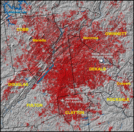
Atlanta, Georgia 1992

|
1990 Population - 2,275,252
Includes Cobb, Douglas, Fulton, Gwinnett, DeKalb, Clayton, and Rockdale Counties. NOTE: portions of the above listed counties may not be visible on the map Red areas shown as developed land 375,000 acres (586 square miles) |
Atlanta's prominence as both an intraregional and interregional urban center continued to draw in-migration during most of the 20th century. Recent growth has centered on the north side of the metropolitan area, where the natural amenities found in the foothills region are a major attraction. Rapid urban expansion has brought about the usual problems of increasing air pollution, traffic congestion, and socioeconomic division. This socioeconomic imbalance is noticeable not only within the metropolitan area, but when northern Georgia, dominated by Atlanta, is compared with the State's more rural south. Another issue has been greater Atlanta's expanding water needs. Interbasin transfers into the Chattahoochee system are altering regional hydrologic conditions and causing conflicts between Georgia, Alabama, and Florida. |