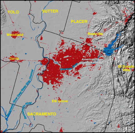
Sacramento, California 1973


|
1970 Population - 803,793
Includes Yolo, Placer, and Sacramento Counties. NOTE: portions of the above listed counties may not be visible on the map Red areas shown as developed land 115,800 acres (181 square miles) |
The City of Sacramento lies between the Sierra Nevada Mountains and the Pacific Coast Range in northern California, at the confluence of the American and Sacramento Rivers. The discovery of gold at Sutter's Mill on the American River in 1848 led to the city's creation. Scars from hydraulic gold mining in the area can still be seen today. Sacramento was the first city in California to be incorporated (1850) and by 1854 had become the State capital. It was also the western terminus of the Pony Express and the first transcontinental railroad. Early on, the Sacramento region was recognized for its agricultural potential, with rich alluvial soils and abundant water. |
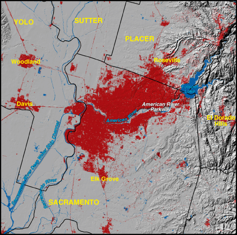
Sacramento, California 1992

|
1990 Population - 1,355,225
Includes Yolo, Placer, and Sacramento Counties. NOTE: portions of the above listed counties may not be visible on the map Red areas shown as developed land 186,600 acres (292 square miles) |
River management issues, such as flood control, irrigation and urban needs, and natural restoration, now figure in debates over water resources. Pesticides in urban storm runoff, mostly from residential landscaping, are also a concern. Sacramento County ranked 22nd nationally in absolute population gain between 1970 and 1980 and 13th between 1980 and 1990. The increase of low-density growth led to strict land use planning during the 1970s. Officials encouraged "infilling" of undeveloped areas within the urban boundary. In the 1980s, a light rail transit system was created, but existing highways have still had to be expanded, especially where the metropolitan region is extending into the Sierra foothills, which are laden with natural amenities. |