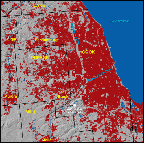
Chicago, Illinois 1973

|
1970 Population - 6,612,195
Includes Lake, Cook, DuPage, and Will Counties. NOTE: portions of the above listed counties may not be visible on the map Red areas shown as developed land 519,300 acres (811 square miles) |
Chicago was established in 1836 near a portage between Lake Michigan and the Illinois-Mississippi river system. The trade route via the Great Lakes and the Erie Canal helped residents secure Northeastern financial backing that transformed the city into a railroad hub after 1850. As a break-in-bulk point between eastern and western markets, Chicago grew into a metropolis by 1890. Thanks to distribution networks and an expanding workforce of first European immigrants and then southern African-American migrants, the city boomed as a manufacturing center. Later, a diversified economy helped the city make the transition from manufacturing to service-based industries. Suburban expansion continues, especially to the west and northwest. |
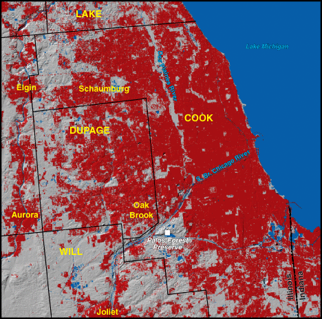
Chicago, Illinois 1992
|
1990 Population - 6,760,464
Includes Lake, Cook, DuPage, and Will Counties. NOTE: portions of the above listed counties may not be visible on the map Red areas shown as developed land 641,800 acres (1,003 square miles) |
Chicago's growth led to change. Wetland filling altered the local hydrology. Access to gently rolling farmland encouraged development. The relatively level land surface created little resistance to growth, but the area's urban development stayed close to transportation corridors, especially commuter rail lines, until recently. Urban infilling has occurred in recent decades, many times focusing on local aesthetically pleasing physical amenities. A desire to retain open spaces in an urban setting led to the creation of reserved land in forest preserves and riparian strips, such as the Palos Forest Preserve and those along the Des Plaines River. |