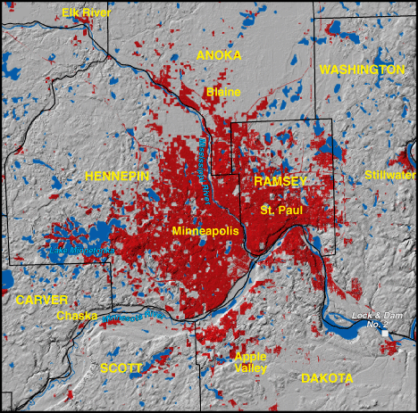
Minneapolis-St. Paul, Minnesota 1973


|
1970 Population - 1,874,612
Includes Anoka, Washington, Dakota, Scott, Carver, Hennepin, and Ramsey Counties. NOTE: portions of the above listed counties may not be visible on the map Red areas shown as developed land 228,200 acres (356 square miles) |
Minneapolis and St. Paul were founded approximately 10 miles apart along the upper reaches of the Mississippi River by the 1850s. St. Paul was at the end of navigation and Minneapolis at the site of significant waterpower. They became marketing centers for timber from the northern forests and agricultural commodities from the prairie. The Twin Cities developed into a regional railroad hub and a centralized source of wholesale goods and financial services for much of the Upper Midwest, including northern Montana. The metropolitan area flourished after World War II. Local entrepreneurs founded several corporations that rose to national prominence. |
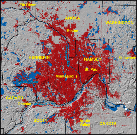
Minneapolis-St. Paul, Minnesota 1992

|
1990 Population - 2,228,663
Includes Anoka, Washington, Dakota, Scott, Carver, Hennepin, and Ramsey Counties. NOTE: portions of the above listed counties may not be visible on the map Red areas shown as developed land 355,400 acres (555 square miles) |
Throughout the second half of the 20th century, a diversified economy and perceived opportunities continued to attract new residents, many from the surrounding rural region, stimulating significant urban growth. The glacial lakes in the metropolitan area often attracted development because of their desired natural amenity. Now surrounded by a far-flung suburban periphery, the Twin Cities have been called one of the Nation's most "sprawling" urban areas. A progressive metropolitan farmland protection program was established but was vulnerable to voluntary, short-term (8-year) enrollments. An influential regional planning council has tried to channel growth, but some of the fastest growing communities are beyond its jurisdictional control. |