Circular 1291
Appendix 8C. Analytical Approach and Methods for Organochlorine Pesticides in Stream Bed Sediment and Whole Fish
This appendix provides information on the approach and methods for the analysis of organochlorine pesticide data for bed sediment and whole fish from U.S. streams, provided in USGS Circular 1291, Pesticides in the Nation's Streams and Ground Water, 1992–2001: The Quality of Our Nation's Waters (Gilliom and others, 2006).
Study design and site selection: Bed sediment and tissue (BS&T) sites were sampled by NAWQA Study Units as part of the Occurrence and Distribution Survey (Gilliom and others, 1995). This survey targeted certain constituents—including organochlorine pesticide compounds—that are likely to be associated with particulates in streams.
Stream sampling sites in each Study Unit were selected in accordance with the NAWQA national design strategy (Gilliom and others, 1995). Two general types of stream sites were selected for monitoring—“Integrator Sites” and “Indicator Sites.” Integrator Sites represent water quality in large basins that is often affected by mixed land uses or a wide variety of natural influences. They are located at key points (such as the outlet) in the drainage network of a Study Unit. Indicator Sites represent water quality in smaller, more homogeneous basins that is often affected by a single land use or a more limited number of natural influences. Indicator Sites are located in targeted areas of relatively homogeneous land use and physiographic conditions (Gilliom and others, 1995, p. 11–12). The targeted land uses include agricultural, urban, and undeveloped forest or rangeland (U.S. Geological Survey, 1999, p. 30). Stream sites sampled for the NAWQA program were not selected to be statistically representative of the Nation’s land use or any other factor. Rather, the NAWQA national design is intended to provide a framework for comparing water-quality among sites to improve the understanding of the relation between water quality and land use, pesticide use, soils, climate, and other natural or human influences.
Bed-sediment and tissue was sampled at a total of about 15–30 stream sites in each Study Unit. Typically, these sites included the 3–5 Integrator and 4–8 Indicator sites that were sampled for nutrients and dissolved pesticides in stream water, plus additional Indicator sites selected to include (a) areas where nonpoint contamination is known or expected; (b) streams that drain each major environmental setting (which are subareas with relatively homogeneous combinations of natural features and land-use conditions) within the Study Unit, and (or) (c) additional reference settings (typically undeveloped land).
The study design called for collecting one composite sediment sample and one composite tissue sample (either clams or fish) at each BS&T site for analysis of organochlorine compounds. In practice, appropriate fish or clam taxa were not available at all NAWQA stream sites. Of the 1,145 total BS&T sites, 607 sites have both sediment and whole fish samples, 445 sites have sediment samples only, and 93 sites have fish samples only. Of the 51 NAWQA Study Units, 49 collected bed-sediment samples and 45 collected at least some fish samples. Two Study Units—Delmarva Peninsula (DLMV) and Yakima River Basin (YAKI)—are not represented in the national database for bed sediment. Six Study Units are not represented in the national database for fish: Delmarva Peninsula (DLMV), Georgia-Florida Coastal Plain (GAFL), Las Vegas Valley Area and the Carson and Truckee River Basins (NVBR), Santa Ana Basin (SANA), Upper Tennessee River Basin (UTEN), and Yakima River Basin (YAKI).
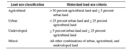
Classification of sites by land use: A nationally consistent approach was used to classify stream sites by land use. Each site was classified into one of four land-use classes—agricultural, urban, undeveloped, and mixed—depending on the amount of agricultural, urban, and undeveloped land within the watershed. This approach does not take into account all factors that affect water quality at the site, but instead aims to characterize the land use associated with the streamflow (water) at the site. An initial determination of land use within each watershed was made using an enhanced version of the 1992 National Land Cover Data (NLCD), which classifies land use for each 30-meter-square area of land in the conterminous U.S. The original and enhanced versions of the NLCD are described, respectively, by Vogelmann and others (2001) and Nakagaki and Wolock (2005). The percentage of the watershed corresponding to each of three aggregated land-use categories was calculated: total agricultural land (including row crops, pasture, and orchards), total urban land (including residential and commercial-industrial), and total undeveloped land (including forest and rangeland). The criteria specified in table A below (also shown as table 3–1 of Circular 1291) were applied to classify each site on the basis of the percentage of land in these three aggregated categories.
Table A. National criteria for classifying NAWQA stream sites according to the dominant land use(s) in their watersheds.
A few sites (fewer than 5 percent) had their classifications adjusted if one or more land uses makes a disproportionately large or small contribution (relative to its percentage of land area in the watershed) to streamflow at the site because of water management practices or natural variations in precipitation and runoff. This is especially common in the arid west, where water resources are heavily managed.
Sample collection and processing:
Bed-sediment sampling: Bed-sediment samples were collected at 1,052 stream sites. Each sample was a composite of fine-grained surficial sediment collected from multiple depositional zones within a stream reach at a stream site on a single date, resulting in a reach average of fine-grained surficial sediment. The composite sediment sample was processed through a 2.0 mm stainless steel sieve prior to analysis. Details on sampling methods are provided in Shelton and Capel (1994).
Tissue sampling: A single taxon generally was sampled at each site, although multiple taxa were collected at about 10 percent of sites. Taxa were selected from a National Target Taxa List, and the same taxon was sampled at as many sites as possible within the Study Unit.
Fish samples were collected at a total of 700 stream sites. Each fish sample was a composite of 5–8 individual whole fish (all belonging to a single taxon) collected at the site on the same date. Nationally, the most commonly sampled fish taxa were common carp (29 percent of samples) and white sucker (25 percent). Details on the design and methods for biological tissue sampling are provided in Crawford and Luoma (1994).
Freshwater clams (Corbicula fluminea, the Asian clam) were collected at about 200 sites. Most of these sites were in the southeastern and western United States because Corbicula has a limited geographic distribution. Only 17 of the 51 NAWQA Study Units collected clam samples at any sites, and clam sampling was discontinued by 1998. Data for organochlorine compounds in clam tissue are not discussed further here or included in Circular 1291. (See Summary Statistics, 1992–1998, for the most recent national summary statistics for organochlorine pesticide compounds in clam tissue).
Pesticides, analytical methods, and reporting levels:
Bed-sediment and tissue samples were analyzed for up to 32 organochlorine pesticide compounds, consisting of 19 parent pesticides and 13 degradates and manufacturing by-products. By medium, 31 individual pesticide compounds were analyzed in sediment, and 27 in fish. Results for organochlorine pesticides are sometimes described for pesticide groups (such as “total DDT”) because all compounds in the group are derived either from common parent pesticides (for example, the isomers p,p´-DDD and p,p´-DDE are degradates of p,p´-DDT), or from indistinguishable pesticide products (for example, dieldrin may originate from application of dieldrin or as a degradate of aldrin). These pesticide groups are identified and defined in Appendix 1B (see footnotes). Together, the organochlorine pesticides examined by NAWQA account for more than 90 percent of the Nation’s historical use (by weight) of organochlorine pesticides in agriculture, and a substantial portion of urban and suburban insecticide use through the 1980s (Gilliom and others, 2006).The chemical analyses of bed-sediment and tissue samples were conducted at the U.S. Geological Survey’s (USGS) National Water Quality Laboratory (NWQL). Details on the analytical methods for organochlorine compounds in sediment and tissue are published elsewhere (Foreman and others, 1995; and Leiker and others, 1996, respectively). Briefly, sediment samples were dried, and a sub-sample was Soxhlet-extracted with dichloromethane, cleaned up by gel permeation chromatography (GPC), solvent-exchanged to hexane, fractionated using alumina/silica adsorption chromatography, and analyzed by gas chromatography with electron capture detection (GC/ECD). Tissue samples were homogenized and a sub-sample was dried, Soxhlet-extracted with dichloromethane, and an aliquot was removed for lipid determination. The extract was cleaned up by GPC, solvent-exchanged to hexane, fractionated using alumina/silica adsorption chromatography, then analyzed by GC/ECD.
Organochlorine pesticide compounds analyzed in bed sediment and tissue are listed in Appendix 1B, along with their analytical reporting levels. Concentrations below these reporting levels may be observed—however, the method cannot reliably (consistently) detect lower concentrations, which may result in underestimation of the number of samples in which a given compound occurs at concentrations less than its reporting level. Any concentrations reported below these reporting levels are considered to be “estimated.” In addition, concentrations are remarked as “estimated” if they were less than the lowest calibration standard or extrapolated above the highest calibration standard, or if samples were diluted to bring concentrations within the range of the calibration standards.
Water-quality data: The bed sediment and fish tissue data summarized in USGS Circular 1291 (Gilliom and others, 2006) were obtained from the U.S. Geological Survey Data Warehouse on July 30, 2002. The compiled data were reviewed prior to data analysis. Unusually high concentrations or apparent anomalies (for example, substantial p,p’-DDT in the absence of p,p’-DDE) were verified with Study Unit personnel and (or) the NWQL, as appropriate.
In some samples, data were missing for individual pesticide compounds. These samples were dropped from the analyses for the affected compounds—that is, they were not counted as either detections or nondetections, or used in the calculation of frequencies of benchmark exceedance.
Some analytical values were not used in the national assessment. For both sediment and fish data, samples with raised reporting levels (that is, reported as not detected above a specified concentration that is higher than the reporting level, such as <10 µg/kg for a compound with a reporting level of 5 µg/kg) are treated as missing data—that is, they were dropped from the analyses for the affected compounds.
Low-level detections of pesticides in sediment and fish were not “censored” at their respective reporting levels, with one exception. (“Censoring” data below a specified concentration consists of treating any detection below this concentration as a non-detection, so that detections are reported at or above this specified concentration; this method is often used when comparing the detection frequencies of two compounds with different analytical sensitivities. For example, when three samples with reported concentrations of 1, <5, and 10 µg/kg are censored at a threshold of 5 µg/kg, they become <5, <5, and 10 µg/kg.) Because bed-sediment samples from one Study Unit (Potomac River Basin) had much lower reporting levels than all other Study Unit samples, the Potomac sediment data were censored to make them comparable to sediment data from the other Study units. Specifically, the Potomac sediment data were censored at the lowest estimated concentration in samples from the other (non-Potomac) Study Units—in other words, any concentration in a Potomac sample that was below the lowest concentration detected in any other Study Unit sample was treated as a nondetection. If a compound was detected only in Potomac sediment samples, then this compound was censored in Potomac samples at the reporting level for that compound in non-Potomac samples.
Selection of samples for the national assessment: Not all of the bed-sediment and fish samples collected were used in the national data analysis for Circular 1291. For each site, only one sample (of each sampling medium) was used, so that results from individual sites are weighted equally and have comparable precision. At the majority of BS&T sites, only one sediment sample and (or) one fish sample are available. However, for some sites, multiple samples (of a given sampling medium) were collected in different years or as replicates for quality control purposes. Also, at some sites, multiple fish samples were collected, each representing a different fish taxon. If multiple samples of a given sampling medium were available for a given site, one sample (for each sampling medium) was selected for the national assessment according to the following criteria: For sediment, the earliest sample that did not have missing data for key analytes (due to analytical problems or interferences) was selected. For fish, the sample was selected from among the samples collected during the earliest year; of those, the earliest sample of the taxon that was most commonly sampled in the Study Unit (usually also the most common taxon nationally) was selected. In the final database used in this analysis, 62 different fish taxa were used, of which the most common were common carp (29% of fish samples) and white sucker (25% of fish samples).
Summary statistics: Data for all stream sites within a land-use class were pooled, and detection frequencies and concentration percentiles were calculated for each pesticide compound in each of the four national land-use classes: agricultural, urban, undeveloped, and mixed land-use sites. Detection frequencies and concentration percentiles also were calculated for two pesticide groups, total DDT and total chlordane (see Summed concentrations for related pesticide analytes, below). All calculations were based on one sample per stream site. Missing data for individual pesticide compounds were not included in these calculations. Summary statistics for bed sediment and whole fish are reported in Appendices 7C and 7D.
Detection frequencies: The detection frequency indicates the percentage of samples (sites) in which a given compound was detected, which is a function of the sensitivity of the analytical method used for that compound in that medium. In bed sediment, detection frequencies were calculated using four detection thresholds: (1) “total detection frequency” (detections at any concentration—some as low as 2 µg/kg dry weight); (2) detections at or greater than 1 µg/kg dry weight; (3) detections at or greater than 2 µg/kg; and (4) detections at or greater than 5 µg/kg . In fish, detection frequencies were calculated for two detection thresholds: (1) “total detection frequency” (detections at any concentration—some as low as 0.8 µg/kg wet weight); and (2) detections greater than or equal to 5 µg/kg wet weight.
Within a given sampling medium, detection frequencies among pesticide compounds are directly comparable if a common detection threshold is used. Only one pesticide has a reporting level higher than 5 µg/kg (the highest detection threshold used) in either sediment or fish—toxaphene, which is a complex mixture and has a reporting level of 200 µg/kg in both media. The total detection frequency for toxaphene is biased low relative to total detection frequencies of pesticide compounds with much lower reporting levels, so toxaphene cannot be directly compared to the other pesticide compounds analyzed in sediment or fish.
For each of the four land use classes, for each medium (sediment and fish), and for each detection threshold, the frequency of detection for each pesticide compound was calculated as follows:
(n / N) * 100
Where N is the number of samples analyzed for the pesticide compound and n is the number of samples in which the specific pesticide compound was detected at or above the threshold. This is equivalent to “censoring” the data at the threshold concentration (“Censoring" data was described previously).
Percentiles of concentration: The maximum concentration was determined and five concentration percentiles (25th, 50th, 75th, 90th, and 95th) were calculated for each pesticide compound (plus total DDT and total chlordane), for each land-use class and for each medium. Percentiles were computed using the Statistical Analysis System (SAS) Proc Univariate procedure. Percentiles of concentration for land-use classes were computed by ranking all nondetections lower than any detection within the land-use class. Any calculated percentile less than the lowest detection in the land-use class was considered a nondetection.
Percentiles provide information about the magnitude of concentrations at selected points in the cumulative frequency distribution of the concentrations. For example, dieldrin concentrations in sediment were greater than or equal to 27 µg/kg at 5 percent of urban sites, greater than or equal to 12 µg/kg at 10 percent of urban sites, and greater than or equal to 2.1 µg/kg at 25 percent of urban sites (table 7C-2).
Summed concentrations for related pesticide analytes: For groups of related pesticide compounds (identified in Appendix 1B), such as total DDT, a total concentration for the group was calculated by summing the concentrations of all components in the group. For example, total DDT consists of the sum of concentrations of o,p´-DDT, p,p´-DDT, o,p´-DDD, p,p´-DDD, o,p´-DDE, and p,p´-DDE. Total chlordane is the sum of concentrations of cis-chlordane, trans-chlordane, cis-nonachlor, trans-nonachlor, and oxychlordane. Total DDT and total chlordane represent the pesticide active ingredient(s), manufacturing by-products, and degradates of two different technical pesticide mixtures: technical DDT and technical chlordane, respectively. In summing the concentrations of all the components in each group, non-detections were treated as zero concentrations. Also, any missing values (such as due to raised reporting levels) for component compounds in a group were treated as zero concentrations.
Additional methods and approach: Additional information on methods and approach for bed-sediment and whole-fish analyses for individual figures in Circular 1291 is provided in the online supplemental information section of each figure.
Crawford, J. K. and Luoma, S.N., 1994, Guidelines for studies of contaminants in biological tissues for the National Water-Quality Assessment Program: U.S. Geological Survey, Open-File Report 92-494.
Foreman, W.T., Conner, B.F., Furlong, E.T., Vaught, D.G., and Merten, L.M, 1995, Methods of analysis by the U.S. Geological Survey National Water Quality Laboratory—determination of organochlorine pesticides and polychlorinated biphenyls in bottom sediment by dual capillary-column gas chromatography with electron-capture detection: U.S. Geological Survey, Open-File Report 95-140.
Gilliom, R.J., Alley, W.M., and Gurtz, M.E., 1995, Design of the National Water-Quality Assessment Program—occurrence and distribution of water-quality conditions: U.S. Geological Survey Circular 1112, 33 p. [Available at: http://water.usgs.gov/pubs/circ/circ1112/]
Gilliom, R.J.; Barbash, J.E.; Crawford, C.G.; Hamilton, P.A.; Martin, J.D.; Nakagaki, Naomi; Nowell, L.H.; Scott, J.C.; Stackelberg, P.E.; Thelin, G.P.; and Wolock, D.M.; 2006, Pesticides in the Nation's streams and ground water, 1992–2001—the quality of our Nation's waters: U.S. Geological Survey Circular 1291, 171p. [Available at: URL http://water.usgs.gov/nawqa/pnsp/pubs/circ1291/]
Gilliom, R.J. and Helsel. D.R., 1986. Estimation of distributional parameters for censored trace level water quality data 1—estimation techniques: Water Resources Research, v. 22, no. 2, p. 135-146.
Helsel, D.R., and Cohn, T.A., 1988, Estimation of descriptive statistics for multiply censored water quality data: Water Resources Research, v. 24, no. 12, p. 1997-2004.
Helsel, D.R. and Gilliom, R.J., 1986, Estimation of distributional parameters for censored trace level water quality data 2—verification and applications: Water Resources Research, v. 22, no. 2, p. 147-155.
Larson, S.J., Capel, P.D., and Majewski, M.S., 1997, Pesticides in surface waters—distribution, trends, and governing factors, Gilliom, R.J., ed., Pesticides in the Hydrologic System, v. 3: Ann Arbor Press, Inc., Chelsea, Michigan.
Leiker, T.T.J., Madsen, J.E., Deacon, J.R., and Foreman, W.T., 1996, Methods of analysis by the U.S. Geological Survey National Water Quality Laboratory—determination of chlorinated pesticides in aquatic tissue by capillary-column gas chromatography with electron-capture detection: U.S. Geological Survey, Open-File Report 94-710.
Majewski, M.S., and Capel, P.D., 1995, Pesticides in the atmosphere—distribution, trends, and governing factors, Gilliom, R.J., ed., Pesticides in the Hydrologic System, v. 1: Ann Arbor Press, Inc., Chelsea, Michigan.
Nakagaki, Naomi, and Wolock, D.M., 2005, Estimation of agricultural pesticide use in drainage basins using land cover maps and county pesticide data: U.S. Geological Survey Open-File Report 2005-1188, 46 p.
Nowell, L.H., Capel, P.D., and Dileanis, P.D., 1999, Pesticides in stream sediment and aquatic biota—distribution, trends, and governing factors, Gilliom, R.J., ed., Pesticides in the Hydrologic System, v. 4: Ann Arbor Press, Inc., Chelsea, Michigan. Abstract available at: http://water.usgs.gov/nawqa/pnsp/pubs/abs/abp.html
SAS Institute Inc., 2002, Base SAS: SAS Institute Inc., accessed January 13, 2002 at http://www.sas.com/products/base/index.html
Shelton, L.R., and Capel, P.D., 1994, Guidelines for collecting and processing samples of stream bed sediment for analysis of trace elements and organic contaminants for the National Water-Quality Assessment Program: U.S. Geological Survey Open-File Report 94-458, 20 p. [Available at: http://water.usgs.gov/nawqa/pnsp/pubs/ofr94-458/]
U.S. Environmental Protection Agency, 1998, Guidance for data quality assessment—practical methods for data analysis, EPA QA/G9, QA97 version: U.S. Environmental Protection Agency, Office of Research and Development EPA/600/R-96/084. [Available at http://www.epa.gov/region10/www/offices/oea/epaqag9.pdf]
U.S. Geological Survey, 1999, The quality of our Nation’s waters—nutrients and pesticides: U.S. Geological Survey Circular 1225, 82 p. [Available at: http://water.usgs.gov/pubs/circ/circ1225/]
Vogelmann, J.E., Howard, S.M., Yang, L., Larson, C.R., Wylie, B.K., and VanDriel, Nick, 2001, Completion of the 1990’s national land cover dataset for the conterminous United States from Landsat Thematic Mapper data and ancillary data sources: Photogrammetric Engineering and Remote Sensing, v. 67, p. 650–662.
Wong, C.S., Capel, P.D., and Nowell, L.H., 2000, Organochlorine pesticides and PCBs in stream sediment and aquatic biota—initial results from the National Water-Quality Assessment Program, 1992-1995: U.S. Geological Survey Water-Resources Investigations Report 00-4053, Sacramento, CA, 88 p. [Available at http://water.usgs.gov/nawqa/pnsp/pubs/wrir004053/]
Pesticide names and analytical methods are presented in Appendix 1B.
Information on sampling sites and their characteristics is presented in Appendix 5C.
Downloadable concentration data are presented in Appendix 6C (bed sediment) and Appendix 6D (whole fish).
Summary statistics by land-use class and by stream-water site are presented in Appendix 7C (bed sediment) and Appendix 7D (whole fish).
For more information, contact:
Jeffrey D. Martin
U.S. Geological Survey
NAWQA Pesticide Synthesis Project
5957 Lakeside Boulevard
Indianapolis , IN 46278-1996
voice: (317) 290-3333 x148
fax: (317) 290-3313
email: jdmartin@usgs.gov

![]() U.S. Department of the Interior |
U.S. Geological Survey
U.S. Department of the Interior |
U.S. Geological Survey
URL: http://pubsdata.usgs.gov/pubs/circ/2005/1291/appendix8c.html
Page Contact Information: GS Pubs Web Contact
Page Last Modified: Tuesday, 30-Oct-2018 13:59:47 EDT
