Geographic Analysis and Monitoring Program
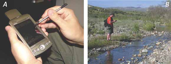
Examples of hand-held mobile-computing technology. A, Portable digital assistant (PDA). B, Scientist using a PDA in the field (from figure 1).
To assess the opportunities and needs for mobile-computing technology at the U.S. Geological Survey (USGS), we conducted an internal, Internet-based survey of bureau scientists whose research includes fieldwork. In summer 2005, 144 survey participants answered 65 questions about fieldwork activities and conditions, technology to support field research, and postfieldwork data processing and analysis. Results suggest that some types of mobile-computing technology are already commonplace, such as digital cameras and Global Positioning System (GPS) receivers, whereas others are not, such as personal digital assistants (PDAs) and tablet-based personal computers (tablet PCs). The potential for PDA use in the USGS is high: 97 percent of respondents record field observations (primarily environmental conditions and water-quality data), and 87 percent take field samples (primarily water-quality data, water samples, and sediment/soil samples). The potential for tablet PC use in the USGS is also high: 59 percent of respondents map environmental features in the field, primarily by sketching in field notebooks, on aerial photographs, or on topographic-map sheets. Results also suggest that efficient mobile-computing-technology solutions could benefit many USGS scientists because most respondents spend at least 1 week per year in the field, conduct field sessions that are least 1 week in duration, have field crews of one to three people, and typically travel on foot about 1 mi from their field vehicles. By allowing researchers to enter data directly into digital databases while in the field, mobile-computing technology could also minimize postfieldwork data processing: 93 percent of respondents enter collected field data into their office computers, and more than 50 percent spend at least 1 week per year on postfieldwork data processing. Reducing postfieldwork data processing could free up additional time for researchers and result in cost savings for the bureau. Generally, respondents support greater use of mobile-computing technology at the USGS and are interested in training opportunities and further discussions related to data archiving, access to additional digital data types, and technology development.
Download this report as a 30-page PDF file (c1299.pdf; 2.2 MB)
USGS Techniques and Methods 11-C1 Geographic Information System Software to Enhance Field-Data Collection and Management of Land Cover Trends Information, by Nathan Wood, Benjamin Sleeter, and Peter Ng.
For questions about the content of this report, contact Nate Wood
Download a copy of the latest version of Adobe Reader for free.
|
Help |
PDF help |
Publications main page |
| Western Circulars |
| Geography | Geographic Analysis and Monitoring Program
|

![]() U.S. Department of the Interior |
U.S. Geological Survey
U.S. Department of the Interior |
U.S. Geological Survey
URL: https://pubs.usgs.gov/circ/2006/1299/
Page Contact Information: Michael Diggles
Page Last Modified: December 19, 2006
