Prudhoe Bay, Alaska
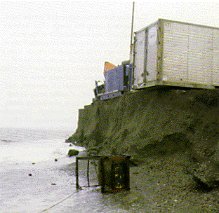
This dock facility at Prudhoe Bay shows the effects of northern Alaska's coastal erosion problem. Strong storm waves and ice action cause the erosion rates in the Beaufort Sea to be among the highest in the United States. Some barrier islands are moving landward as fast as 7 meters per year. These rapid erosion rates endanger causeways and artificial islands built for oil-drilling platforms.
| Maintained by J.M. Watson | https://pubs.usgs.gov/circ/c1075/prudhoe.html | Last updated 9.11.97 |