
|
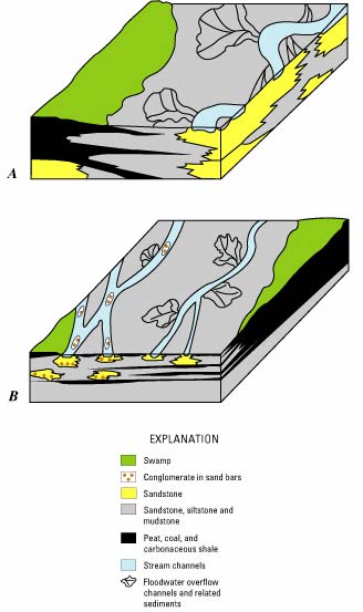
Figure 8. Block-diagram models illustrating some of the peat-sediment- climate relationships possible in the process of peat development and burial. These models explain the environments of deposition for two large coal deposits of Paleocene age in the Powder River basin of Wyoming. No specific scale implied, but the blocks represent general areas of approximately 9 to 25 mi2, and depths of approximately 50 to 100 ft. A, Decker-Tongue River area. This peat deposit developed continuously in the same place because low areas, formed by faulting or compaction of underlying sediments, may have restricted the location of a meandering stream to the edge of the peat deposit. Also, the river system may have had a somewhat restricted sediment supply, or the river system may not have been vigorous enough to invade the peat swamp except at the margin. The climate probably was wet most of the year because the peat surface in the model is shown to be higher than the surface of the stream valley. A wet climate promotes vigorous plant growth on top of the peat, which holds water like a sponge, allowing the peat to pile up above the surrounding area. The result is a large, thick, clean, coal deposit. B, Kaycee-Linch area. In this case, the river system apparently had a coarser and more abundant sediment supply and was more vigorous than in part A, as shown by the conglomerate bars in some of the stream channels, which are a sign of stronger current flow. This river system was able to move back and forth across the peat swamps, limiting the resulting deposits, in part, to thin, discontinuous beds. This environment appears also to have been wet, but a better supply of sediment and stronger stream flows limited peat preservation. Modified from Flores and others (1989), used with permission of the American Geophysical Union. |
U.S. Department of the Interior, U.S. Geological Survey
URL: https://
pubsdata.usgs.gov
/pubs/circ/c1143/html/fig8.html
For more information, contact Stanley Schweinfurth
Maintained by Eastern Publications Group
Last modified:
12:29:03 Wed 23 Nov 2016
Privacy statement | General disclaimer | Accessibility