Organizations Represented by Poster Presentations
Carroll County (Md.) Government
Loudoun County (Va.) Government, Office of Mapping and Geographic Information
Maryland Geological Survey
Pennsylvania Geological Survey
U.S. Geological Survey Biological Resources Division
Leetown Science Center (W. Va.)
Patuxent Wildlife Research Center (Md.)
U.S. Geological Survey Geologic Division
Eastern Region National Cooperative Geologic Mapping Team, USGS
Eastern Region Mineral Resource Surveys Team, USGS
U.S. Geological Survey National Mapping Division, Mapping Applications Center (MAC)
U.S. Geological Survey Water Resources Division, Md.-Del.-D.C. District
Virginia Division of Mineral Resources
Virginia Extension Service, Loudoun County Office
Washington Metropolitan Area Transit Authority
Abstracts
[Poster presenters were given the option of submitting abstracts]
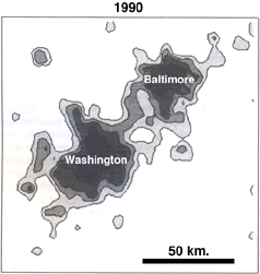
Using Space/Time Transformations to Map Urbanization in the
Baltimore-Washington Region
Lee De Cola, U.S. Geological Survey,
521 National Center, Reston VA 20192, ldecola@usgs.gov
|
During the past year, researchers at the U.S. Geological Survey have been using historical maps and digital data for a 168- by 220-km area of the Baltimore-Washington region to produce a dynamic data base that shows growth of the transportation system and built-up area for 270-m grid cells for several years between 1792 and 1992. A "Mathematica" package was developed that spatially generalizes and temporally interpolates these data to produce a smoothly varying urban intensity surface showing important features of the 200-year urban process.
The boxcount fractal dimension of a power-2 grid pyramid was used to determine the most appropriate level of spatial generalization. Temporal interpolation was then used to predict urban intensity for 4,320-m cells for 10-year periods from 1800 to 1990. These estimations were spatially interpolated to produce a 1,080-m grid field that is animated as a surface and as an isopleth (contour) map. This technique can be used to experiment with future growth scenarios for the region, to map other kinds of land cover change, and even to visualize quite different spatial processes, such as habitat fragmentation caused by climate change.
For the animation, see:
http://geog.gmu.edu/gess/classes/geog590/gis_internet/ldecola/baltwash/
Sinkholes and Karst-Related Features within the Baltimore-Washington Urban Corridor: Frederick and Winchester 30'x60' Quadrangles, Virginia, West Virginia, and Maryland
Randall C. Orndorff and Scott Southworth,
U.S. Geological Survey, 926A National Center, Reston, VA 20192
Sinkholes, caves, pinnacled bedrock, and other karst-related features occur in four distinct areas in the Virginia, West Virginia, and Maryland part of the central Appalachians--the Great Valley, the northwest part of the early Mesozoic Culpeper basin, the Frederick Valley, and the western Piedmont east of the Frederick Valley. We are currently mapping the distribution of carbonate rock and karst features within the Frederick 30'x60' quadrangle as part of a regional geologic study of the Baltimore-Washington urban corridor. Karst in these areas poses potential environmental and engineering hazards associated with industrial and urban development.
The long agricultural history of the area and the recent increase in industrial and urban development have increased the potential for ground-water contamination. Ground water can be rapidly transported in limestone and dolostone through joints, faults, and bedding planes enlarged by solution. The complex hydrogeologic systems associated with karst create difficulties in predicting the rate and direction of ground-water movement. Potential sources of contamination include agricultural runoff, industrial pollution, leaking underground storage tanks, regional landfills, sinkhole dumps, and private septic systems. Also, ground-water contamination can affect surface water quality where it rises to the surface at springs.
Sinkhole collapse, which involves the sudden vertical mass movement of residuum and bedrock, is a hazard in areas of carbonate bedrock in the central Appalachians and needs to be considered in engineering and geotechnical studies and in land-use planning. Both natural processes and man's influence contribute to the risk. For example, a common cause of collapse is a drop in the water table due to extended droughts or excessive pumping of ground water. In the study area, subsidence typically occurs over long periods of time by solutional enlargement of joints, faults, and bedding planes. However, sudden collapse of residuum and bedrock does occur. Since 1992, extensive property damage has resulted from collapse sinkholes in Clarke County, Va., and Frederick and Carroll Counties, Md.
Factors that control sinkhole development include lithologic characteristics, fracture density in bedrock, and the proximity of carbonate rocks to streams. Sinkholes tend to be more abundant and larger in size (depth and diameter) near entrenched streams where the hydraulic gradient is steepened and the rate of ground-water flow is increased. However, in areas with poor surface drainage, lithologic characteristics are the most important factor controlling sinkhole development.
Significant portions of the Baltimore-Washington urban corridor are underlain by carbonate rock but exhibit no surface expression of subsidence features. Here, too, karst processes are active. In these areas, karst is expressed by poorly developed surface drainage, as well as minor solutional sculpting of exposed bedrock. Areas such as these present a variety of potential problems for land users, including relatively rapid movement of contaminated ground water, and difficulties in engineering building foundations due to differential compaction, soil piping, and collapse of subsurface cavities.
Lithogeochemical Map Units and Water Quality Patterns in the Chesapeake Bay Watershed
John Peper and Lucy McCartan,
U.S. Geological Survey, 926A National Center, Reston, VA 20192
Geologists and hydrologists have long noted close relationships between major-element rock chemistry, as expressed by rock type, and the chemistry of the contained waters. Generally, for example, limestones yield hard, alkaline waters, whereas black shales, carbonaceous schists, and peat yield reducing, oxygen-poor waters. Quartzose sediments and rocks have little capacity to neutralize acid or to buffer waters. Maps of Maryland and eastern Virginia, using a lithogeochemical classification scheme, show regional patterns of predicted water quality effects and areas of reduction and elimination of nitrate pollutants.
A lithogeochemical rock classification, based on the predicted ability of Mid-Atlantic rocks and sediments to buffer and interact with their contained waters, has shown a significant degree of correlation with observed water chemistry in four areas previously studied by aqueous geochemists in and near the Chesapeake Bay watershed. On the seaward side of the mouth of Chesapeake Bay, organic deposits mapped in Cape Charles and Norfolk Counties, Va., reduce and eliminate nitrates infiltrating from above. In Frederick County, Md., limestones in the Frederick Valley have the highest acid neutralizing capacity, followed by Catoctin Formation metabasalt; the intervening phyllite and quartzite (resistates) are essentially nonreactive with the acidic stream water. East of Chesapeake Bay, relatively unweathered greensand in Kent County, Md., reduces and eliminates nitrates infiltrating through highly oxidized greensand and quartz sand and gravel above.
Digital and Open-File
Products of the
Pennsylvania Geological Survey
Helen L. Delano, Christopher D. Laughrey, and Thomas Whitfield,
Pennsylvania Department of Conservation and Natural Resources,
Bureau of Topographic and Geologic Survey,
P.O. Box 8453, Harrisburg, PA 17105; delano.helen@a1.dcnr.state.pa.us
The Wells Information System (WIS), developed in the Subsurface Geology Division of the Pennsylvania Geological Survey is an ARC/INFO and ORACLE data base that will manage the Survey's collection of well records from over 300,000 oil and gas wells drilled in the State since 1869. The data base contains information about well locations, well completion data, interpreted stratigraphy, petroleum production, geophysical well logs, and well cuttings and core sample. The purpose of WIS is to provide the public with an automated file cabinet and research tool. WIS provides the citizens of Pennsylvania with a detailed interactive data base for analyzing and evaluating the status of drilling, oil and gas production, and subsurface stratigraphy in Pennsylvania.
Two other data bases track the Commonwealth's water wells. Much of the data are field verified; some are obtained from drillers reports. Some information is available on ground-water quality.
Other digital data collections that are available or being developed include Non-Coal Mineral Producers in Pennsylvania, Earthquake Epicenters in and near Pennsylvania, and Sinkholes and Karst Features.
Many of our recent reports and maps are now released on open-file. Recent products include (1) Surficial Geology in the Allentown Area and (2) Surficial Geology of Southern York and Lancaster Counties. These are available as black-and-white copies prepared on the 7.5-minute topographic base.
Karst features mapped on 7.5-minute quadrangles are available for 14 counties, mostly in the Great Valley and southeastern Pennsylvania.
A number of other reports and maps on a variety of topics and areas are also available on open-file. A current list and ordering instructions will be available at this forum or can be obtained by contacting the Survey at P.O. Box 8453, Harrisburg, PA 17105; phone (717)787-2169. More information on digital data files is available from the same address.
Geologic Map of the
Washington West 30'x60' Quadrangle, District of Columbia, Virginia, and Maryland
Peter T. Lyttle, John N. Aleinikoff, Avery Ala Drake, Jr., Albert J. Froelich, J. Wright Horton, Jr., Gregorius Kasselas, Lucy McCartan, Robert M. Mixon, Arthur E. Nelson, Louis Pavlides, and Robert E. Weems,
U.S. Geological Survey, 926A National Center, Reston, VA 20192
The Washington West 30'x60' quadrangle covers an area of approximately 4,884 km 2 in and west of the Washington, D.C., metropolitan area. The eastern part of the area is highly urbanized, and rural fringe areas to the west are rapidly being developed. The area lies entirely within the Chesapeake Bay drainage basin and mostly within the Potomac River watershed. It contains part of the Nation's main north-south transportation corridor east of the Blue Ridge Mountains. Extensive Federal land holdings in addition to those in Washington, D.C., include the Marine Corps Development and Education Command at Quantico, Fort Belvoir, Vint Hill Farms Station, the Naval Ordnance Station at Indian Head, the Chesapeake and Ohio Canal National Historic Park, Great Falls Park, and Manassas National Battlefield Park. The quadrangle contains most of Washington, D.C.; part or all of Arlington, Culpeper, Fairfax, Fauquier, Loudoun, Prince William, Rappahannock, Stafford, and Clarke Counties in northern Virginia; and parts of Charles, Montgomery, and Prince Georges Counties in Maryland. This geologic map is intended to serve as a foundation for applying geologic information to problems involving land-use decisions, ground-water availability and quality, earth resources such as natural aggregate for construction, assessment of hazards, and engineering and environmental studies for waste-disposal sites and construction projects. This 1:100,000-scale map is largely based on more detailed geologic mapping at the scale of 1:24,000 and serves as an index to such information where it is available.
The Washington West quadrangle spans four geologic provinces. From west to east these provinces are the Appalachian Blue Ridge, the early Mesozoic Culpeper basin, the Appalachian Piedmont, and the Atlantic Coastal Plain. The Blue Ridge province, which occupies the western part of the quadrangle, contains metamorphic and igneous rocks of Middle Proterozoic to Early Cambrian age exposed in the Blue Ridge anticlinorium. Middle Proterozoic rocks in the hinge area of the anticlinorium are mostly granitic, although older metasedimentary rocks are also present. Late Proterozoic granitic rocks of the Robertson River Igneous Suite intrude the Middle Proterozoic rocks. The Middle Proterozoic rocks are nonconformably overlain by Late Proterozoic arkosic metasedimentary rocks of the Fauquier and Lynchburg Groups, which in turn are overlain by metabasalts of the Catoctin Formation. The Catoctin Formation is overlain by Late Proterozoic and Lower Cambrian metasedimentary clastic rocks of the Chilhowee Group, which consists of the Weverton Quartzite and overlying Harpers Formation.
Crystalline rocks of the Appalachian Piedmont province, which underlie the east-central part of the quadrangle, occur between the overlapping sedimentary units of the Culpeper basin on the west and those of the Atlantic Coastal Plain on the east. In this area, the Piedmont contains Late Proterozoic and lower Paleozoic metamorphosed sedimentary, volcanic, and intrusive rocks. Allochthonous melange complexes on the western side of the Piedmont are bordered on the east by metavolcanic and metasedimentary rocks of the Chopawamsic Formation, which has been interpreted as part of an early Cambrian(?) volcanic arc. The melange complexes are unconformably overlain by metasedimentary rocks of the Popes Head Formation. The Ordovician Quantico Formation is the youngest metasedimentary unit in this part of the Piedmont. Igneous rocks include the Garrisonville Mafic Complex, transported ultramafic and mafic blocks in melanges, monzogranite of the Dale City pluton, and Ordovician tonalitic and granitic plutons. Jurassic diabase dikes are the youngest intrusions. The fault boundary between rocks of the Blue Ridge and Piedmont provinces is concealed beneath the Culpeper basin in this quadrangle but is exposed farther south in Virginia.
The Culpeper basin of northern Virginia and Maryland is located in a belt of Late Triassic to Early Jurassic fault-bounded troughs exposed in eastern North America from Nova Scotia to the Carolinas. These troughs, containing nonmarine Newark Supergroup strata, are generally in alignment with the structural grain of enclosing Paleozoic and Proterozoic metamorphic rocks. Lower Mesozoic rocks of the Culpeper basin unconformably overlie those of the Piedmont and Blue Ridge provinces in the central part of the map. The north-northeast-trending extensional basin contains Upper Triassic to Lower Jurassic fluvial, lacustrine, and playa clastic sedimentary rocks, mainly "red beds" and conglomerates. Lower Jurassic basalt flows are interbedded with the sedimentary rocks, and both Upper Triassic and Lower Jurassic strata are intruded by diabase of Early Jurassic age. The Bull Run fault on the west side of the basin is a major Mesozoic normal fault characterized by down-to-the-east displacement. It separates Culpeper basin rocks from those of the Blue Ridge province. An unconformity on Piedmont province rocks, which has been locally disrupted by normal faults, marks the east side of the Culpeper basin.
Sediments of the Atlantic Coastal Plain unconformably overlie rocks of the Piedmont along the Fall Zone and occupy the eastern part of the quadrangle. Lower Cretaceous deposits of the Potomac Formation (equivalent to the Potomac Group in Maryland and northward) consist of fluvial-deltaic gravels, sands, silts and clays. West of the Potomac River, these Cretaceous strata are capped by discontinuous gravel sheets of middle to late Tertiary and Quaternary age. East of the Potomac River, the Potomac Formation is unconformably overlain by marine sedimentary deposits of Late Cretaceous and early to late Tertiary age and by upper Tertiary nonmarine gravel, sand, and mud. Fluvial and estuarine terrace deposits of Pleistocene and latest Tertiary age flank the modern Potomac River. Faults of Tertiary to Quaternary age occur west and north of the river.
When released for publication this map will be available in digital form and will become part of the National Geologic Map Database.
Geology of the Fredericksburg
30'x60' Quadrangle, Northeastern Virginia and Southern Maryland
Robert B. Mixon, Louis Pavlides,
David S. Powars, Robert E. Weems,
Stephen J. Schindler, and Wayne L. Newell,
U.S. Geological Survey, 926A National Center, Reston, VA 20192
The Fredericksburg map encompasses parts of four different terranes--the Atlantic Coastal Plain, the Appalachian Piedmont, the early Mesozoic Culpeper basin, and the Blue Ridge anticlinorium. The Coastal Plain terrane, which constitutes the eastern half of the map area, is an eastward-thickening body of mostly unlithified Cretaceous (144 to 66 million years ago) and Tertiary (66 to 1.8 million years ago) sand, gravel, silt, and clay. Maximum thickness of these deposits in the easternmost part of the area is about 600 m (2,000 ft). Quaternary (less than 1.8 million years ago) sediments occur mainly as a steplike series of fluvial and estuarine terrace deposits that parallel the Rappahannock, Potomac, and Mattaponi Rivers. At the Fall Zone, near the inner edge of the Coastal Plain, a zone of en echelon, northeast-striking, northwest-dipping reverse faults places crystalline rocks of the Piedmont at a high angle over Coastal Plain strata of Cretaceous to Pliocene age (144 to 1.8 million years ago). Episodic faulting began at least as early as the Early Cretaceous and extended into middle and late Tertiary time.
The northeast-trending crystalline-rock terrane of the Piedmont lies between the more easily eroded strata of the Coastal Plain to the east and the Culpeper basin to the west. This terrane consists of metamorphosed sedimentary, volcanic, and plutonic rocks of Late Proterozoic (900 to 540 million years ago) and Paleozoic age (540 to 245 million years ago) and is commonly highly deformed. In the northwestern corner of the map area, Piedmont crystalline rocks are overlain with great angularity by thick continental deposits of the early Mesozoic Culpeper basin, a half graben that trends northeastward through the Virginia and Maryland Piedmont. In the map area, the basin fill is of Triassic age (245 to 208 million years ago) and consists of red and gray shale, siltstone, mudstone, sandstone, and conglomerate of fluvial and lacustrine origin. These sedimentary rocks thicken westward toward the Bull Run Mountain border fault and are intruded by thin to thick diabase sills and dikes of Jurassic age.
Late Proterozoic and Cambrian metabasalts and meta-sediments of the east limb of the Blue Ridge anticlinorium occur in the northwestern corner of the map area. The largest body of these rocks underlies Clark Mountain in the vicinity of Everona, Va. Other areas of Blue Ridge rocks that crop out include a small horst, well within the Culpeper basin, that forms "The Ridge" near Stevensburg, Va., and the relatively upthrown block west of the Culpeper basin border fault at Culpeper, Va.
Our map and the accompanying cross sections may be used to help determine the extent and thickness of aquifers and confining beds, areas of aquifer recharge, sources of natural aggregate including crushed stone and sand and gravel, sources of expandable clay, mineral resources, geotechnical properties of surficial materials and bedrock, and other geologic and hydrologic factors affecting land-use planning. In addition, our map delineates two major zones of faulting (Stafford and Mountain Run) that indicate late Neogene (less than 11 million years ago) movement and, therefore, affect the siting of large structures, such as nuclear generating stations and dams.
Geology of the Frederick 30'x60' Quadrangle, Maryland, Virginia, and West Virginia
Scott Southworth, U.S. Geological Survey, Reston, Va.,
David Brezinski, Maryland Geological Survey, Baltimore, Md., and
Randall Orndorff, Avery Drake, and William Burton,
U.S. Geological Survey, Reston, Va.
Since 1989, the U.S. Geological Survey (USGS) and Maryland Geological Survey (MGS) have been cooperatively mapping bedrock and surficial geology at 1:24,000-scale within the Frederick 30-by-60 minute quadrangle; production of an ARC-INFO geologic map is planned for 1998. The Frederick quadrangle will be the northern part of a three 30-by-60-minute-quadrangle (1:100,000-scale) ARC-INFO data base that forms the core of the Washington-Baltimore urban corridor within the GOMAC Project of the Eastern Region National Cooperative Geologic Mapping Program.
The geology includes parts of the Coastal Plain, Piedmont, Blue Ridge, and Great Valley provinces of the central Appalachians. Bedrock ranges in age from Middle Proterozoic gneiss in the core of the Blue Ridge-South Mountain anticlinorium to Early Paleozoic shale in the core of the Massanutten synclinorium of the Great Valley, undated metamorphosed sedimentary and volcanic rocks in the Piedmont, and Early Mesozoic sedimentary strata and diabase of the Culpeper and Gettysburg basins. Collectively, these rocks constitute evidence for several events of continental collision and rifting.
Quaternary surficial deposits include alluvium, colluvium, and fluvial terraces. Saprolite of deeply weathered metamorphic rocks is restricted to the Piedmont. Carbonate rocks of the Great Valley, and Culpeper basin, Frederick Valley, and Westminster terrane of the Piedmont, have weathered to karst with lag gravels capping hillocks adjacent to sinkholes.
The geologic data base used in the 1:100,000-scale compilation consists of a detailed folio of maps that were produced for specific customers--16 maps at 1:12,000-scale, 6 maps at 1:24,000-scale, and 2 maps at 1:50,000- and 1:100,000-scale for the Loudoun County, Va., Department of Natural Resources and Soil Extension, and parts of 12 1:24,000-scale maps of the C&O Canal National Historical Park for the National Park Service. For site-specific investigations, all of the 32 7.5-minute quadrangles will be available as published color or open-file ozalid geologic maps by the USGS, MGS, Virginia Division of Mineral Resources, and West Virginia Economic and Geological Survey. A major objective of this project is to produce a simplified digital lithologic map to enable cooperative multidisciplinary studies of the relationship of geology to geotechnical properties of materials, soils, water, aggregate resources, and karst subsidence by county, State, and Federal Government agencies. In addition, general interest publications and field trip guides will form a component of outreach and education for this densely populated region.
Mid-Atlantic Geology and Infrastructure Case Study Project
Gilpin R. Robinson, 954 National Center,
U.S. Geological Survey, Reston, VA 20192, and
Valentin V. Tepordei, 983 National Center,
U.S. Geological Survey, Reston, VA 20192
Continued population growth and urbanization, particularly in the urban corridors of the Eastern United States where existing infrastructure is deteriorating and needs maintenance and expansion, will generate huge demands for construction materials. Sand, gravel, and crushed stone are the materials with which our cities are built and are the dominant basic raw material of the economy. Current national production exceeds 2 billion tons of aggregate per year. On the basis of either weight or volume, aggregates account for over two-thirds of the approximately 3.3 billion tons of nonfuel minerals mined in the United States each year. This production trend and resource need will likely continue and grow in the future. These raw materials are indispensable to the maintenance and development of urban environments, and virtually all aggregate that is mined domestically is used locally. Because both geologic and economic market conditions dictate the locations where economically recoverable aggregate and construction raw materials may be produced, opportunities to meet the future demand of the construction industry will be controlled by the availability of the resource.
The successful integration of natural-resource information into land-use decisions is increasingly difficult as the competing needs for lands and resources become more numerous, complex, and urgent. In response to these issues, the aggregate industry has gone through significant changes over the last 30 years. However, a comprehensive analysis of the changes and trends is lacking. The identification of longer term trends and changes is largely anecdotal, and the comprehensive documentation of long-term regional resource production trends, material flows, and supply issues generally does not exist.
The high level of production of construction materials and the significant changes in resource and urban development that have taken place in the Mid-Atlantic region during the last 30 years provide insights into the likely future trends in other areas of the Nation.
The Baltimore-Washington urban corridor has been chosen for the case study because of the availability of a good resource information data base and because, with over 7 million people spread over 39 counties and the District of Columbia, the Baltimore-Washington urban corridor is one of the Nation's fastest growing metropolitan areas.
The case study area will cover the District of Columbia and parts of Maryland, Pennsylvania, Virginia, and West Virginia and will focus on the counties within 38 to 40 degrees N. and 76 to 78 degrees W.
The objectives of the regional case study are to--
- Identify the main geologic sources and locations of high-quality construction resources in the region.
- Document on a county basis, for the last 35 years, how much aggregate was produced and used in the region of study, who produces aggregate, who uses aggregate, and how much they consume.
- Analyze the resource production and demographic information to develop a sensitivity analysis of per capita trends, growth-based trends, and base-level trends for the region.
- Calibrate and validate a geographic information system (GIS) model for the region to develop a resource-demand forecasting tool.
- Analyze county-level management planning and the historic decision record to evaluate the effectiveness of planning in regard to aggregate resources. What comprehensive plans exist, what decisions regarding mineral development have been made, and who makes these decisions?
- Digital data base with inventory of aggregate resources and time-series documentation of regional resource development trends, material flows, and infrastructure development history.
- Information manual identifying current resource producers in the region and the roles and responsibilities of State and county organizations and agencies involved with resource production, permitting, and regulation. The manual will also include summaries of relevant Federal, State, and county rules and
- Analysis tools to forecast future aggregate resource demands.
- Documentation and analysis of emerging land-management and resource-availability issues.
Project Timetable: 3 years.
Cooperators and Collaborators:
- Maryland Geological Survey
- Virginia Division of Mineral Resources
- National Stone Association
Geology of the Waterford, Va., Quadrangle and Virginia Portion of the Point of Rocks Quadrangle and Its Socioeconomic Significance
William C. Burton, Geologist,
926A National Center, U.S. Geological Survey, Reston, VA 20192; bburton@usgs.gov
The bedrock geology of the Waterford quadrangle and of the Virginia part of the Point of Rocks quadrangle consists of a portion of the Mesoproterozoic basement core and its cover sequence on the eastern limb of the Blue Ridge anticlinorium and the adjacent early Mesozoic Culpeper basin. The three major rock associations in this area are (1) Mesoproterozoic gneisses, which are extensively intruded by Neoproterozoic metadiabase dikes; (2) unconformably overlying Neoproterozoic and early Paleozoic metavolcanic and metasedimentary rocks; and (3) Upper Triassic sedimentary strata intruded by Early Jurassic diabase. The Triassic and Jurassic rocks are separated from the older rocks of the anticlinorium to the west by a major normal fault known as the Bull Run fault. Late Cenozoic surficial deposits of three major types unconformably overlie the bedrock--colluvium derived from Catoctin Mountain, terrace deposits of the Potomac River, and flood-plain alluvium of the Potomac River and its tributaries.
The bedrock formations have greatly varying hydrogeologic characteristics and water-well yields. The greenstones of the Catoctin Formation are impermeable and produce some of the lowest yields in Loudoun County. Immediately to the east the highest yields are found in the Triassic sedimentary rocks, specifically the karstic carbonate conglomerate of the Leesburg Member of the Balls Bluff Siltstone. At the south end of the map, the Leesburg Member underlies an area of rapid residential and commercial development on the northern outskirts of Leesburg, which will impact local ground-water quality and supply. The historic town of Waterford, underlain by the gneiss-dike complex, has the highest concentration of wells in Loudoun County, resulting in chronic water shortages. Rapid residential development and water-well drilling is occurring in the surrounding area.
The map area has a history of mineral-resource development, mostly occurring in the 1800's. Limonite (iron ore) was mined from Antietam Quartzite at Furnace Mountain, and thin marble layers in the Swift Run and Catoctin formations were quarried for agricultural lime and building material. Leesburg Member conglomerate was extensively used for agricultural lime, and immediately north of the map area this rock was quarried to make the distinctive columns of the Capitol Building.
|
|
This page is URL https://pubs.usgs.gov/circular/c1148/appendix1.html
Last modified 15 April 1998
Maintained by John Watson and Kathie Watson