
Highlight 1--Linking the Science Goals:
Mineral Resource and Hazard Studies
The scientific issues, products, and actions outlined in the seven science goals are intentionally broader than those currently addressed by any individual GD program. The science goals are also complementary, in that research information and results collected while working on one goal can directly affect research involving other goals. For example, long-term USGS research on volcanic systems has provided a fundamental understanding of the reactions that take place as volcanic gases condense into ground water in the shallow subsurface. The resulting acid-leached rocks are common hosts for gold deposits in volcanic settings. GD hazard-focused studies of active volcanic and geothermal systems have thus added immeasurably to the understanding of the origin and distribution of a broad suite of mineral resources. At the same time, techniques developed to map and locate the alteration assemblages associated with ore deposits can be used to understand volcanic hazards. Remote-sensing, field, and laboratory investigations traditionally conducted in the study of mineral deposits have been used at Mount Rainier to map and interpret the formation of hydrothermal alteration zones at a level of detail previously unrealized on active volcanoes. Such areas of hydrothermally altered and weakened rock have collapsed repeatedly within the last 10,000 years, producing some of the mudflows that inundated portions of what is now the Seattle-Tacoma metropolitan area (fig. 1). By applying mineral-mapping techniques, the GD can refine future hazard assessments while improving the understanding of the environment of formation for volcano-hosted mineral deposits.

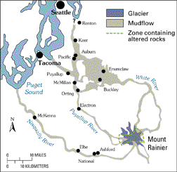
Figure 1. Photograph of Mount Rainier, as seen from Tacoma, WA, and map showing areas of hydrothermally altered rocks and regions covered by mudflows shed from the volcano within the past 5,600 years. Recent work by GD staff has identified regions of hydrothermal alteration that are particularly susceptible to collapse, potentially endangering developed population centers downstream from the volcano. Photograph from the USGS Cascades Volcano Observatory. Map from Sisson (1995).
<----- Back to Executive Summary
This page is <https://pubs.usgs.gov/circular/c1172/h1.html>
Maintained by L. McElroy
Last updated 04.08.98