
Highlight 14--Cleaning Up Boston Harbor
Long-term research and environmental monitoring by the GD in Boston Harbor and Massachusetts Bay have made vital contributions to the $4 billion Boston Harbor clean-up program. Detailed geologic maps constructed from sidescan-sonar surveys of the bay floor were critical to selecting the new location for discharge of treated sewage wastes in Massachusetts Bay. These maps also guided the required monitoring program by identifying regions where fine-grained sediments and sewage-related contaminants are likely to accumulate. Computer models of ocean circulation produced convincing predictions that the upgraded sewage treatment system and proposed discharge site will improve conditions in Boston Harbor without impairing the environmental quality of Massachusetts Bay (fig. 14). Results of the GD research, carried out in cooperation with the Massachusetts Water Resources Authority, also showed that water-quality standards can be met with a smaller secondary treatment facility than originally planned, thereby saving millions of dollars in construction costs.
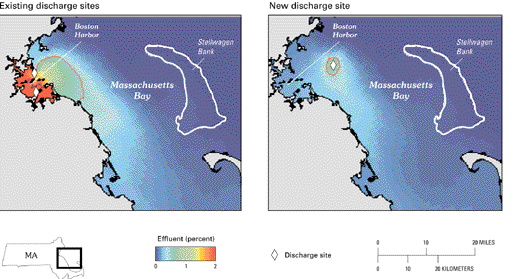
Figure 14. Existing and new discharge sites and effluent distribution in Boston Harbor and Massachusetts Bay. Red line indicates area beyond which nutrient levels in the effluent are comparable to background variability. From Signell and others (1996).
<----- Back to Goal 6
This page is <https://pubs.usgs.gov/circular/c1172/h14.html>
Maintained by L. McElroy
Last updated 04.08.98