
Highlight 3--
Remote-Sensing Studies Save Taxpayers Millions of Dollars
Interdisciplinary USGS studies are playing a key role in the EPA's efforts to clean up mine waste dumps at Leadville, CO, a historic mining district that is now an EPA Superfund site. USGS studies have integrated ground-based geologic and geochemical characterization of the mine dumps with advanced AVIRIS (Airborne Visible and Infrared Imaging Spectrometer) remote-sensing techniques to identify mine dumps that are most likely to generate acid mine drainage and release heavy metals into the environment (fig. 3). AVIRIS is a remote-sensing technology originally developed by NASA to determine the mineralogical and atmospheric character of other planets. USGS applications of AVIRIS technology at Leadville enabled the EPA, its cooperators (including the USBR), and its contractors to rapidly determine which of the many mine waste dumps were in need of remediation and to prioritize the cleanup effort. According to the EPA (Sam Vance, 1997, written commun.), results of the USGS Leadville study ultimately saved taxpayers more than $2 million and trimmed more than 2 years off the estimated completion time of the environmental remediation process.
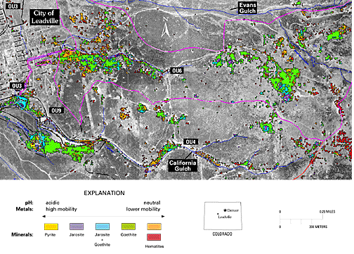
Figure 3. AVIRIS image of the Leadville, CO, mining district, showing distribution of minerals that could lead to acid mine drainage. Blue lines indicate hydrology; pink lines indicate operable unit (OU) 6 boundary. From Swayze and others (1998).
<----- Back to Working with Others
This page is <https://pubs.usgs.gov/circular/c1172/h3.html>
Maintained by L. McElroy
Last updated 04.08.98