
Highlight 5--
Discovery of Significant Earthquake Hazard in the Pacific Northwest
Following the 1964 magnitude 9.2 earthquake in Alaska (the largest historic earthquake to strike U.S. continental territory), a GD geologist recognized a regionally consistent pattern of coastal subsidence that he correctly attributed to slip on a shallowly dipping subduction zone fault. This interpretation was at odds with the initial seismological interpretation for the earthquake but proved to be correct and played a crucial role in the development of plate tectonic theory for convergent margins. A similar subduction zone fault is present along the Oregon and Washington coast, but large earthquakes on this fault are unknown in the historic record. In the mid-1980's, another GD geologist recognized that extensive remains of dead, saltwater-flooded forests along coastal Washington must have resulted from abrupt coastal subsidence; he also recognized that widespread deposits of sand high in coastal estuaries suggested tsunami inundation. With observations from the Alaskan earthquake as an analog and precise dating and regional correlation of the dead forests, the GD geologist deduced that great subduction-zone earthquakes (magnitude 8 to 9) have repeatedly struck the Pacific Northwest in the past thousand years, the most recent one occurring in 1700. As a result, public officials significantly revised the building codes for Oregon and Washington (fig. 5). Throughout most of this region, new buildings are now designed to resist earthquake forces 50 percent larger than they were under the old code, reducing the risk to life and property.
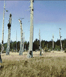
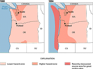
Figure 5. A dead forest in coastal Washington is evidence for a great earthquake that occurred about 1700 (photograph by B.F. Atwater, USGS). Seismic risk-assessment maps for the Uniform Building Code, which includes minimum standards for designing earthquake-resistant structures nationwide, were redrawn after the discovery of evidence of great earthquakes in the Pacific Northwest. Maps from Atwater and others (1995).
<----- Back to Goal 1
This page is <https://pubs.usgs.gov/circular/c1172/h5.html>
Maintained by L. McElroy
Last updated 04.08.98