
Highlight 7--
USGS Response Helps Avert Catastrophe at Mount Pinatubo
On April 2, 1991, villagers of Patal Pinto, on the Island of Luzon, Philip-pines, observed minor ash and steam coming from the upper slopes of Mount Pinatubo, a dormant volcano that had last erupted 500 years before. On April 23, USGS personnel joined ongoing monitoring by the Philippine Institute of Volcanology and Seismology (PHIVOLCS), installed a radio-telemetered seismic network (fig. 7) and tiltmeters, and began measuring volcanic gases. The expanded monitoring efforts were guided, in part, by new technologies developed by the USGS in response to the eruptions of Mount St. Helens, Mount Redoubt, and other volcanoes during the 1980's. Geologic reconnaissance and monitoring soon convinced the USGS-PHIVOLCS team that a large eruption was imminent. Eruption forecasts caused local officials to evacuate about 100,000 residents from the Pinatubo area, including 18,000 U.S. military personnel and their dependents from nearby Clark Air Base. Several days after the forecast, about 5 cubic kilometers (1.2 cubic miles) of magma exploded from Pinatubo, devastating hundreds of square kilometers of the Philippine countryside. It was the second largest volcanic eruption of the 20th century, after the 1912 eruption of Mount Katmai in Alaska.
Losses of at least $US200 million-$275 million were averted by timely movement of military aircraft and other equipment out of the region. Scores of aircraft were warned of the location of ash clouds and steered clear; those few aircraft that failed to heed the warnings suffered about $US100 million in damage. Between 5,000 and 20,000 lives were saved by the timely forecasts. The entire cost of the USGS-PHIVOLCS mission is estimated at $US1.5 million, and development of those agencies' capability to monitor volcanoes and produce short-term forecasts has cost approximately $US15 million over a 10-year period. The Pinatubo event clearly illustrates how long-term investment in scientific understanding can result in enormous benefits.
"All of us who were at Subic Bay during Mount Pinatubo's 1991 eruption owe the outstanding USGS staff a tremendous thank you for timely warnings and very accurate predictions."
--Capt. David Krieger
U.S. Navy
Commanding Officer,
Subic Bay Naval Station
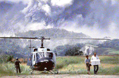
Figure 7. Volcanologists from PHIVOLCS and the USGS attempting to restore seismic signal from Patal Pinto, June 14, 1991. Photograph courtesy of Val Gempis, U.S. Air Force.
<----- Back to Goal 2
This page is <https://pubs.usgs.gov/circular/c1172/h7.html>
Maintained by L. McElroy
Last updated 04.08.98