National Water-Quality Assessment (NAWQA) Program
Design of the National Water-Quality
Assessment Program:
Occurrence and Distribution of Water-Quality Conditions
United States Geological Survey Circular 1112
By Robert J. Gilliom, William M. Alley, and Martin E. Gurtz
ENVIRONMENTAL FRAMEWORK FOR DESIGN
Many factors that affect the sources, behavior, and effects of contaminants
and water-quality conditions are common to most hydrologic systems,
although in widely varying degrees of importance. These common natural and
human-related factors, such as geology and land use, provide a unifying
framework for making comparative assessments of water quality within and
among hydrologic systems at a wide range of scales and characteristics in
different parts of the Nation. Characterizing this Environmental
Framework is an essential element of the Occurrence and Distribution
Assessment that cuts across all individual water-quality issues and
components of Study-Unit and National-Synthesis studies. The Environmental
Framework is used to compare and contrast findings on water quality within
and among Study Units in relation to causative factors and, ultimately, to
develop inferences about water quality in areas that have not been
sampled.
Although it is beyond the scope of this report to fully describe plans for
developing the information base for the Environmental Framework for each
Study Unit, an overview is helpful to understand the approach to sampling
design and data analysis for the Occurrence and Distribution Assessment.
The Environmental Framework is developed at three general scales for each
Study Unit:
- Study Unit. The Environmental Settings of a Study Unit are
initially characterized by dividing it into several major subareas (not
necessarily contiguous) that have relatively homogeneous combinations of
natural features and land-use conditions that generally are relevant to
surface- and ground-water quality. The subareas are mapped and a
conceptual stratification of the hydrologic system is developed. This
general geographic characterization of the Environmental Settings of each
Study Unit supports development of initial conceptual models for evaluating
study priorities and approaches for Study Units and National Synthesis. An
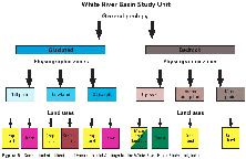
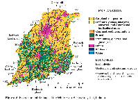
example of the Study-Unit scale of the Environmental Framework is shown
diagrammatically in figure 5 and
geographically in figure 6 for the White
River Basin, Indiana.
In the White River Basin example, the Study Unit is divided into two major
geologic categories, each with three physiographic zones. The
distribution of major land uses among these physiographic zones results in
10 major sub-areas of the Study Unit characterized by the Environmental
Settings that are the primary focus of water-quality investigations.
- Aquifer subunits and stream drainage basins. The ground- and
surface-water resources of each Study Unit are spatially related to aquifer
subunits and drainage basins, respectively, and these are the fundamental
hydrologic units for sampling design. Aquifer subunits that are sampled
and drainage basins that are associated with stream sampling sites are
characterized in a consistent fashion for each Study Unit so that natural
and human-related factors can be compared on an equal basis among Study
Units. High-priority subunits and basins are characterized in much greater
detail than is possible for the entire Study Unit. For example,
agricultural land in a low-priority basin may be sufficiently characterized
as "row crops," whereas in an intensively sampled high-priority basin,
agricultural land will be further characterized in terms of the amount and
location of specific crops cultivated, fertilizer and chemical use,
seasonal timing of activities, and other relevant factors.
- Well sites and stream sampling sites. Natural characteristics
and human activities in the vicinity of each well site and stream site at
which samples are collected are recorded in a consistent format. This
local characterization serves as a high-resolution complement to the
aquifer subunit and drainage basin characterizations.

(Click on image for a larger version, 43K) |
|
Figure 5. Conceptual stratification of Environmental
Settings for the White River Basin Study Unit, Indiana.
| |

(Click on image for a larger version, 85K) |
|
Figure 6. Environmental Settings of the White River Basin
Study Unit, Indiana.
| |
In the following description of the Occurrence and Distribution Assessment
design, the implied development of extensive information on the
Environmental Framework is a key aspect of the study design. Discussion of
specific steps in the study-design process, such as choosing drainage
basins with specific land-use features, gives the reader a general sense of
the application of the Environmental Framework and the nature and scope of
information requirements.
Continue to Surface-Water Study Design, Glossary, or return to Contents


