A
Concepts of Ground Water, Water Table, and Flow Systems
Subsurface Water
Water beneath the land surface occurs in two principal zones, the unsaturated zone and the saturated zone (Figure A-1). In the unsaturated zone, the voids--that is, the spaces between grains of gravel, sand, silt, clay, and cracks within rocks--contain both air and water. Although a considerable amount of water can be present in the unsaturated zone, this water cannot be pumped by wells because it is held too tightly by capillary forces. The upper part of the unsaturated zone is the soil-water zone. The soil zone is crisscrossed by roots, voids left by decayed roots, and animal and worm burrows, which enhance the infiltration of precipitation into the soil zone. Soil water is used by plants in life functions and transpiration, but it also can evaporate directly to the atmosphere.
Figure A-1. The water table is the upper surface of the saturated zone. The water table meets surface-water bodies at or near the shoreline of surface water if the surface-water body is connected to the ground-water system.
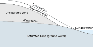
In contrast to the unsaturated zone, the voids in the saturated zone are completely filled with water. Water in the saturated zone is referred to as ground water. The upper surface of the saturated zone is referred to as the water table. Below the water table, the water pressure is great enough to allow water to enter wells, thus permitting ground water to be withdrawn for use. A well is constructed by inserting a pipe into a drilled hole; a screen is attached, generally at its base, to prevent earth materials from entering the pipe along with the water pumped through the screen.
The depth to the water table is highly variable and can range from zero, when it is at land surface, to hundreds or even thousands of feet in some types of landscapes. Usually, the depth to the water table is small near permanent bodies of surface water such as streams, lakes, and wetlands. An important characteristic of the water table is that its configuration varies seasonally and from year to year because ground-water recharge, which is the accretion of water to the upper surface of the saturated zone, is related to the wide variation in the quantity, distribution, and timing of precipitation.
The water table
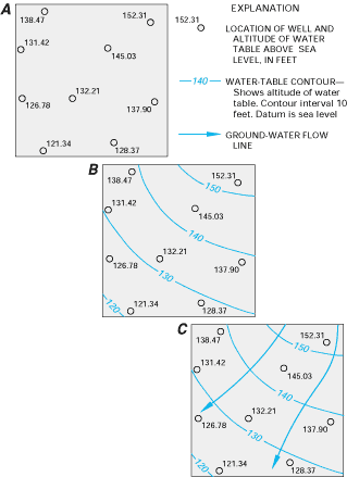
The depth to the water table can be determined by installing wells that penetrate the top of the saturated zone just far enough to hold standing water. Preparation of a water-table map requires that only wells that have their well screens placed near the water table be used. If the depth to water is measured at a number of such wells throughout an area of study, and if those water levels are referenced to a common datum such as sea level, the data can be contoured to indicate the configuration of the water table (Figure A-2). In addition to various practical uses of a water-table map, such as estimating an approximate depth for a proposed well, the configuration of the water table provides an indication of the approximate direction of ground-water flow at any location on the water table. Lines drawn perpendicular to water-table contours usually indicate the direction of ground-water flow along the upper surface of the ground-water system. The water table is continually adjusting to changing recharge and discharge patterns. Therefore, to construct a water-table map, water-level measurements must be made at approximately the same time, and the resulting map is representative only of that specific time.
Figure A-2. Using known altitudes of the water table at individual wells (A), contour maps of the water-table surface can be drawn (B), and directions of ground-water flow along the water table can be determined (C) because flow usually is approximately perpendicular to the contours.
Ground-water movement
The ground-water system as a whole is actually a three-dimensional flow field; therefore, it is important to understand how the vertical components of ground-water movement affect the interaction of ground water and surface water. A vertical section of a flow field indicates how potential energy is distributed beneath the water table in the ground-water system and how the energy distribution can be used to determine vertical components of flow near a surface-water body. The term hydraulic head, which is the sum of elevation and water pressure divided by the weight density of water, is used to describe potential energy in ground-water flow systems. For example, Figure A-3 shows a generalized vertical section of subsurface water flow. Water that infiltrates at land surface moves vertically downward to the water table to become ground water. The ground water then moves both vertically and laterally within the ground-water system. Movement is downward and lateral on the right side of the diagram, mostly lateral in the center, and lateral and upward on the left side of the diagram.
Figure A-3. If the distribution of hydraulic head in vertical section is known from nested piezometer data, zones of downward, lateral, and upward components of ground-water flow can be determined.
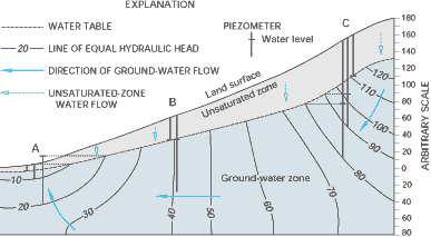
Flow fields such as these can be mapped in a process similar to preparing water-table maps, except that vertically distributed piezometers need to be used instead of water-table wells. A piezometer is a well that has a very short screen so the water level represents hydraulic head in only a very small part of the ground-water system. A group of piezometers completed at different depths at the same location is referred to as a piezometer nest. Three such piezometer nests are shown in Figure A-3 (locations A, B, and C). By starting at a water-table contour, and using the water-level data from the piezometer nests, lines of equal hydraulic head can be drawn. Similar to drawing flow direction on water-table maps, flow lines can be drawn approximately perpendicular to these lines of equal hydraulic head, as shown in Figure A-3.
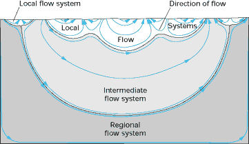
Actual flow fields generally are much more complex than that shown in Figure A-3. For example, flow systems of different sizes and depths can be present, and they can overlie one another, as indicated in Figure A-4. In a local flow system, water that recharges at a water-table high discharges to an adjacent lowland. Local flow systems are the most dynamic and the shallowest flow systems; therefore, they have the greatest interchange with surface water. Local flow systems can be underlain by intermediate and regional flow systems. Water in deeper flow systems have longer flow paths and longer contact time with subsurface materials; therefore, the water generally contains more dissolved chemicals. Nevertheless, these deeper flow systems also eventually discharge to surface water, and they can have a great effect on the chemical characteristics of the receiving surface water.
Figure A-4. Ground-water flow systems can be local, intermediate, and regional in scale. Much ground-water discharge into surface-water bodies is from local flow systems. (Figure modified from Toth, J., 1963, A theoretical analysis of groundwater flow in small drainage basins: p. 75-96 in Proceedings of Hydrology Symposium No. 3, Groundwater, Queen's Printer, Ottawa, Canada.)
Ground-water discharge
The quantity of ground-water discharge (flux) to and from surface-water bodies can be determined for a known cross section of aquifer by multiplying the hydraulic gradient, which is determined from the hydraulic-head measurements in wells and piezometers, by the permeability of the aquifer materials. Permeability is a quantitative measure of the ease of water movement through aquifer materials. For example, sand is more permeable than clay because the pore spaces between sand grains are larger than pore spaces between clay particles.